You are using an out of date browser. It may not display this or other websites correctly.
You should upgrade or use an alternative browser.
You should upgrade or use an alternative browser.
WEATHER Severe Weather the Week of October 28th, 2024
- Thread starter packyderms_wife
- Start date
Walbash
Contributing Member
A Very Sneaky Storm Threat Is Brewing...
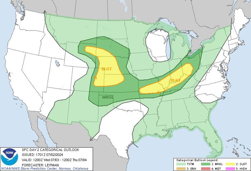
Ryan Hall forecast for this week RT 13:17They've increased the chances of nasty storms since this morning.

NWS Storm Prediction Center Norman OK
1240 PM CDT Tue Oct 29 2024
Valid 301200Z - 311200Z
...THERE IS AN ENHANCED RISK OF SEVERE THUNDERSTORMS ACROSS PORTIONS
OF NORTHWESTERN MISSOURI...EASTERN KANSAS...AND NORTHEASTERN
OKLAHOMA...
...SUMMARY...
Strong/severe thunderstorms, capable of producing large hail,
damaging wind gusts, and a few tornadoes, are expected on Wednesday
across central portions of the country -- particularly from the
middle Missouri Valley area southward to North Texas.
...Synopsis...
An upper trough initially aligned across the interior West will
progress east-northeastward out of the Rockies and into the Plains
during the afternoon and evening, and then will continue onward
toward/into the Mid- and Upper-Mississippi Valley area overnight.
At the surface, a cold front will initially extend
northeast-to-southwest across the central U.S. -- from the Lake
Superior vicinity southwestward to southeastern New Mexico and Far
West Texas. This front will make only gradual eastward progress
initially, as a frontal wave develops in the southeastern Kansas
vicinity and then shifts quickly northeastward along the baroclinic
zone through the day -- to a position near Topeka around sunset.
From there, as the low deepens and progresses toward Wisconsin, the
trailing cold front will begin to surge more quickly
eastward/southeastward, and should extend across central Illinois,
southeastern Missouri, Arkansas, to central Texas by Thursday
morning.
...Mid-Mississippi/Mid-Missouri Valleys across northeastern Texas...
As the advancing upper system shifts out of the Rockies and across
the High Plains through the day, large-scale ascent -- focused near
the cold front -- will gradually increase. Ahead of the front, a
moist (60s dewpoints) airmass will be in place along/ahead of the
front across the central/southern Plains, and should spread
northward across Iowa and into Wisconsin through the day. This,
combined with daytime heating and modestly steep lapse rates aloft,
will allow gradual/steady destabilization to occur through the
morning and afternoon hours.
Initial storm development is forecast by mid to late morning, in the
eastern Nebraska/northeastern Kansas/western Iowa vicinity, and then
expanding northeastward toward the upper Mississippi Valley, and
southward across eastern Kansas, through the afternoon.
In addition to the amply unstable environment that will be evolving
(mixed-layer CAPE in the 1000 to 1500 J/kg range), increasingly
favorable shear will also evolve with time. This will occur as
mid-level southwesterly flow associated with the advancing upper
system spreads eastward across the central Plains, atop low-level
southerly flow near/ahead of the forecast track of the frontal low.
The resulting wind field -- veering favorably and increasing in
speed with height through the lowest half of the troposphere -- will
support supercells. It appears that convection should remain at
least somewhat cellular through the daylight hours from the
Topeka/Kansas City vicinity southward, which would correspond with
risk for a few tornadoes, along with large hail and damaging wind
potential.
Farther to the northeast, across Iowa and into Wisconsin, risk
should remain lower, given lesser instability. Overall, storms
should gradually grow upscale linearly, and will shift eastward with
time across Iowa and into Missouri -- and eventually Illinois
overnight, accompanied by at least limited severe risk into the
overnight hours.
Farther south into Oklahoma and Texas, storm development should
occur later, likely not until after dark. Still, with the
thermodynamic and kinematic environment favoring rotating storms,
the all-hazards severe risk should expand southward across Oklahoma
and into northern and possibly central Texas. With time, storms
should grow upscale linearly across this region as well, after the
initial/primarily cellular mode. Like areas farther north, at least
some severe risk should continue overnight, spreading eastward into
Arkansas and East Texas with time.
..Goss.. 10/29/2024
Red boxes up in OK and KS.
Blue boxes NE of that.
Blue boxes NE of that.
Walbash
Contributing Member
Ryan Hall started a live stream
View: https://www.youtube.com/watch?v=C7Z5HrMtmNM
LIVE - Severe Weather Coverage With Storm Chasers On The Ground, Live Weather Channel...
The First Tornado Warning today is in Iowa,
College of DuPage Meteorology
Severe Weather and Flash Flood Warnings
Note: This page will reload every 2 minutes. Warnings are listed with the most recent first.
Click on the station ID to bring up list of recent severe weather statements.
TORNADO WARNING DES MOINES IA - KDMX 354 PM CDT WED OCT 30 2024
SVR T-STORM WARNING NORMAN OK - KOUN 353 PM CDT WED OCT 30 2024
SVR T-STORM WARNING NORMAN OK - KOUN 347 PM CDT WED OCT 30 2024
SVR T-STORM WARNING NORMAN OK - KOUN 338 PM CDT WED OCT 30 2024
SVR T-STORM WARNING WICHITA KS - KICT 335 PM CDT WED OCT 30 2024
SVR T-STORM WARNING DODGE CITY KS - KDDC 322 PM CDT WED OCT 30 2024
SVR T-STORM WARNING NORMAN OK - KOUN 309 PM CDT WED OCT 30 2024
SVR T-STORM WARNING WICHITA KS - KICT 302 PM CDT WED OCT 30 2024
SVR T-STORM WARNING NORMAN OK - KOUN 255 PM CDT WED OCT 30 2024
SVR T-STORM WARNING NORMAN OK - KOUN 226 PM CDT WED OCT 30 2024
SVR T-STORM WARNING WICHITA KS - KICT 222 PM CDT WED OCT 30 2024
SVR T-STORM WARNING DODGE CITY KS - KDDC 220 PM CDT WED OCT 30 2024
SVR T-STORM WARNING DES MOINES IA - KDMX 214 PM CDT WED OCT 30 2024
SVR T-STORM WARNING KANSAS CITY/PLEASANT HILL MO - KEAX 156 PM CDT WED OCT 30 2024
PrairieMoon
Veteran Member
The First Tornado Warning today is in Iowa,
Yep, and I am just NE of this in the same county. I told my DD I thought I was safe visiting Iowa in October!
It has since resolved, thankfully.
I was up on the Kansas border earlier.
Did my doin's and beat feet back south.
The sky is fairly ominous down here even.
Did my doin's and beat feet back south.
The sky is fairly ominous down here even.
Warnings are compiled here....
tornado hq - tornado tracker and current tornado warnings
In a tornado warning? Use our tornado tracker map to see if a tornado might be headed your way.
www.tornadohq.com
Live storm chasers...

 www.severestudios.com
 livestormchasing.com

Live Storm Chasing, Watch Storm Chasers in Real Time!
Experience live storm chasing & watch top storm chasers stream dashboard video of tornados and extreme weather as it happens. Compatible with Android & iOS.
 www.severestudios.com
Live Storm Chasing
Watch live feeds as storm chasers try to see if their target verifies. Tornadoes, hurricanes, blizzards, and floods - we've got it all and more, live on our site and available as video on demand.
Marthanoir
TB Fanatic
Valencia , Spain had a years worth of rain in one night , nearly 100 dead.
My eyes are closing as its nearly 1am but here's a link.

 www.breakingnews.ie
My eyes are closing as its nearly 1am but here's a link.
Death toll of devastating flash floods in eastern Spain approaches 100

Death toll of devastating flash floods in eastern Spain approaches 100 | BreakingNews.ie
Spanish prime minister Pedro Sanchez said dozens of towns had been flooded.
Last edited:
Marthanoir
TB Fanatic
Sorry dude but had to laugh at the picture
von Koehler
Has No Life - Lives on TB
Heavy rains lasting for for hours with high winds.
Clearing up now, but cellphone reception still weak. Strangely enough TV reception got better during storms.
Southeast Iowa
Clearing up now, but cellphone reception still weak. Strangely enough TV reception got better during storms.
Southeast Iowa
etdeb
Veteran Member
E Texas forecast severe weather day Nov 5thI might have a look at what the forecast is for battle states next five days.
eta:miss you already, opie.
7 day precip.
It's gonna rain.
Not counting that tropical system in the Caribbean.

It's gonna rain.
Not counting that tropical system in the Caribbean.

night driver
ESFP adrift in INTJ sea
R.I.P. PW...
tiredude
Veteran Member
I did the same thing. Trying to get home from ks/co…….ripR.I.P. PW...
We're under a flood watch til Monday night.
Tehrnader watch.


auxman
Deus vult...
Tornado outbreak in OK right now...
View: https://twitter.com/NWSSPC/status/1852983088219115665?s=19
View: https://twitter.com/NWSSPC/status/1852983088219115665?s=19
auxman
Deus vult...
Max Velocity live stream...

 www.youtube.com

EMERGENCY COVERAGE - LARGE TORNADO ON THE GROUND IN OKLAHOMA
BECOME A MEMBER, JOIN THE VELOCITIES - https://www.youtube.com/@MaxVelocityWX/join DONATE - PayPal - https://streamelements.com/maxvelocitywx/tipVenmo -...
auxman
Deus vult...
KOCO 5 live stream...

 www.youtube.com

Tracking severe storms in Oklahoma
WATCH LIVE | Severe storms with a flooding risk are moving across Oklahoma, including the OKC metro. Get the latest details here: https://tinyurl.com/mm2xz4sa


