
You are using an out of date browser. It may not display this or other websites correctly.
You should upgrade or use an alternative browser.
You should upgrade or use an alternative browser.
WEATHER Severe Weather the Week of April 29th, 2024
- Thread starter packyderms_wife
- Start date


packyderms_wife
Neither here nor there.
packyderms_wife
Neither here nor there.
RT 8:40 - Ryan Hall y'all
In this video, we are talking about more rounds of severe weather on the way.
packyderms_wife
Neither here nor there.
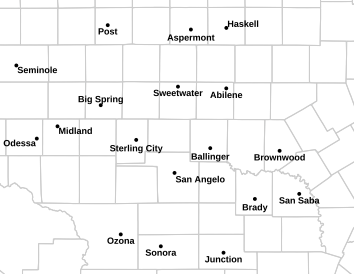
Severe Weather Statement
National Weather Service San Angelo TX
356 PM CDT Fri May 3 2024
TXC081-032130-
/O.COR.KSJT.TO.W.0018.000000T0000Z-240503T2130Z/
Coke TX-
356 PM CDT Fri May 3 2024
...A TORNADO WARNING REMAINS IN EFFECT UNTIL 430 PM CDT FOR
NORTHWESTERN COKE COUNTY...
At 356 PM CDT, a confirmed large and extremely dangerous tornado was
located near Silver, moving south at 15 mph.
This is a PARTICULARLY DANGEROUS SITUATION. TAKE COVER NOW!
HAZARD...Damaging tornado.
SOURCE...Weather spotters confirmed tornado.
IMPACT...You are in a life-threatening situation. Flying debris may
be deadly to those caught without shelter. Mobile homes
will be destroyed. Considerable damage to homes,
businesses, and vehicles is likely and complete destruction
is possible.
Locations impacted include...
E.V. Spence Reservoir Near Paint Creek Recreation Area and Silver.
PRECAUTIONARY/PREPAREDNESS ACTIONS...
To repeat, a large, extremely dangerous and potentially deadly
tornado is on the ground. To protect your life, TAKE COVER NOW! Move
to a basement or an interior room on the lowest floor of a sturdy
building. Avoid windows. If you are outdoors, in a mobile home, or in
a vehicle, move to the closest substantial shelter and protect
yourself from flying debris.
&&
LAT...LON 3208 10070 3208 10063 3199 10050 3187 10059
3199 10079 3209 10071
TIME...MOT...LOC 2050Z 022DEG 14KT 3201 10070
TORNADO...OBSERVED
TORNADO DAMAGE THREAT...CONSIDERABLE
MAX HAIL SIZE...2.00 IN
$$
packyderms_wife
Neither here nor there.
Tornado Warning
TXC081-032145-
/O.NEW.KSJT.TO.W.0019.240503T2107Z-240503T2145Z/
BULLETIN - EAS ACTIVATION REQUESTED
Tornado Warning
National Weather Service San Angelo TX
407 PM CDT Fri May 3 2024
The National Weather Service in San Angelo has issued a
* Tornado Warning for...
Western Coke County in west central Texas...
* Until 445 PM CDT.
* At 407 PM CDT, a large and extremely dangerous tornado was located
over The Intersection Of Highway 158 And Ranch Road 2059, or near
E.V. Spence Reservoir Near Paint Creek Recreation Area, moving
south at 15 mph.
This is a PARTICULARLY DANGEROUS SITUATION. TAKE COVER NOW!
HAZARD...Damaging tornado.
SOURCE...Radar indicated rotation.
IMPACT...You are in a life-threatening situation. Flying debris
may be deadly to those caught without shelter. Mobile
homes will be destroyed. Considerable damage to homes,
businesses, and vehicles is likely and complete
destruction is possible.
* The tornado will be near...
E.V. Spence Reservoir Near Paint Creek Recreation Area around 410
PM CDT.
Other locations impacted by this tornadic thunderstorm include The
Intersection Of Highway 208 And Ranch Road 2662 and The Intersection
Of Highway 158 And Ranch Road 2059.
PRECAUTIONARY/PREPAREDNESS ACTIONS...
To repeat, a large, extremely dangerous and potentially deadly
tornado is on the ground. To protect your life, TAKE COVER NOW! Move
to a basement or an interior room on the lowest floor of a sturdy
building. Avoid windows. If you are outdoors, in a mobile home, or in
a vehicle, move to the closest substantial shelter and protect
yourself from flying debris.
&&
LAT...LON 3200 10076 3200 10046 3171 10042 3171 10082
3173 10082
TIME...MOT...LOC 2107Z 359DEG 12KT 3193 10065
TORNADO...RADAR INDICATED
TORNADO DAMAGE THREAT...CONSIDERABLE
MAX HAIL SIZE...2.50 IN
$$
packyderms_wife
Neither here nor there.
Severe Thunderstorm Warning
TXC081-353-032200-
/O.NEW.KSJT.SV.W.0158.240503T2059Z-240503T2200Z/
BULLETIN - EAS ACTIVATION REQUESTED
Severe Thunderstorm Warning
National Weather Service San Angelo TX
359 PM CDT Fri May 3 2024
The National Weather Service in San Angelo has issued a
* Severe Thunderstorm Warning for...
Northwestern Coke County in west central Texas...
Southwestern Nolan County in west central Texas...
* Until 500 PM CDT.
* At 358 PM CDT, a severe thunderstorm was located near Silver,
moving south at 15 mph.
HAZARD...Two inch hail and 70 mph wind gusts.
SOURCE...Radar indicated.
IMPACT...People and animals outdoors will be injured. Expect hail
damage to roofs, siding, windows, and vehicles. Expect
considerable tree damage. Wind damage is also likely to
mobile homes, roofs, and outbuildings.
* This severe thunderstorm will be near...
E.V. Spence Reservoir Near Paint Creek Recreation Area around 415
PM CDT.
Other locations impacted by this severe thunderstorm include The
Intersection Of Highway 158 And Ranch Road 2059.
PRECAUTIONARY/PREPAREDNESS ACTIONS...
For your protection move to an interior room on the lowest floor of a
building.
A Tornado Watch remains in effect until 1000 PM CDT for west central
Texas.
&&
LAT...LON 3212 10041 3179 10039 3180 10082 3184 10083
3209 10080 3209 10071 3208 10067 3210 10066
TIME...MOT...LOC 2058Z 359DEG 12KT 3202 10069
THUNDERSTORM DAMAGE THREAT...CONSIDERABLE
HAIL THREAT...RADAR INDICATED
MAX HAIL SIZE...2.00 IN
WIND THREAT...RADAR INDICATED
MAX WIND GUST...70 MPH
$$
packyderms_wife
Neither here nor there.
Tornado Warning
TXC081-032145-
/O.NEW.KSJT.TO.W.0019.240503T2107Z-240503T2145Z/
BULLETIN - EAS ACTIVATION REQUESTED
Tornado Warning
National Weather Service San Angelo TX
407 PM CDT Fri May 3 2024
The National Weather Service in San Angelo has issued a
* Tornado Warning for...
Western Coke County in west central Texas...
* Until 445 PM CDT.
* At 407 PM CDT, a large and extremely dangerous tornado was located
over The Intersection Of Highway 158 And Ranch Road 2059, or near
E.V. Spence Reservoir Near Paint Creek Recreation Area, moving
south at 15 mph.
This is a PARTICULARLY DANGEROUS SITUATION. TAKE COVER NOW!
HAZARD...Damaging tornado.
SOURCE...Radar indicated rotation.
IMPACT...You are in a life-threatening situation. Flying debris
may be deadly to those caught without shelter. Mobile
homes will be destroyed. Considerable damage to homes,
businesses, and vehicles is likely and complete
destruction is possible.
* The tornado will be near...
E.V. Spence Reservoir Near Paint Creek Recreation Area around 410
PM CDT.
Other locations impacted by this tornadic thunderstorm include The
Intersection Of Highway 208 And Ranch Road 2662 and The Intersection
Of Highway 158 And Ranch Road 2059.
PRECAUTIONARY/PREPAREDNESS ACTIONS...
To repeat, a large, extremely dangerous and potentially deadly
tornado is on the ground. To protect your life, TAKE COVER NOW! Move
to a basement or an interior room on the lowest floor of a sturdy
building. Avoid windows. If you are outdoors, in a mobile home, or in
a vehicle, move to the closest substantial shelter and protect
yourself from flying debris.
&&
LAT...LON 3200 10076 3200 10046 3171 10042 3171 10082
3173 10082
TIME...MOT...LOC 2107Z 359DEG 12KT 3193 10065
TORNADO...RADAR INDICATED
TORNADO DAMAGE THREAT...CONSIDERABLE
MAX HAIL SIZE...2.50 IN
$$
packyderms_wife
Neither here nor there.
Large tornado on the ground near Edith Texas, it is a very large & dangerous tornado!
packyderms_wife
Neither here nor there.
Connor Croff is followng the tornado near Edith TX, Vince Waelti is following the other tornado on the ground near EV Spence
View: https://www.youtube.com/watch?v=E_mZf0kpsXs
LIVE STREAM - Vince Waelti.
LIVE STREAM - Vince Waelti.
packyderms_wife
Neither here nor there.
He has the best view of that one tornado.
packyderms_wife
Neither here nor there.
The tornado near Robert Lee, TX has been upgraded to a PDS tornado.
packyderms_wife
Neither here nor there.
South Texas PDS Warning ---> A very dangerous rain wrapped tornado!
Tornado Warning
TXC081-451-032215-
/O.NEW.KSJT.TO.W.0020.240503T2124Z-240503T2215Z/
BULLETIN - EAS ACTIVATION REQUESTED
Tornado Warning
National Weather Service San Angelo TX
424 PM CDT Fri May 3 2024
The National Weather Service in San Angelo has issued a
* Tornado Warning for...
Southwestern Coke County in west central Texas...
North central Tom Green County in west central Texas...
* Until 515 PM CDT.
* At 422 PM CDT, a confirmed large and extremely dangerous tornado
was located near E.V. Spence Reservoir Near Paint Creek Recreation
Area, or just west of Robert Lee, moving south at 15 mph.
This is a PARTICULARLY DANGEROUS SITUATION. TAKE COVER NOW!
HAZARD...Damaging tornado.
SOURCE...Weather spotters confirmed tornado.
IMPACT...You are in a life-threatening situation. Flying debris
may be deadly to those caught without shelter. Mobile
homes will be destroyed. Considerable damage to homes,
businesses, and vehicles is likely and complete
destruction is possible.
* This tornadic thunderstorm will remain over mainly rural areas of
southwestern Coke and north central Tom Green Counties, including
the following locations... The Intersection Of Highway 208 And
Ranch Road 2662 and The Intersection Of Highway 158 And Ranch Road
2059.
PRECAUTIONARY/PREPAREDNESS ACTIONS...
To repeat, a large, extremely dangerous and potentially deadly
tornado is on the ground. To protect your life, TAKE COVER NOW! Move
to a basement or an interior room on the lowest floor of a sturdy
building. Avoid windows. If you are outdoors, in a mobile home, or in
a vehicle, move to the closest substantial shelter and protect
yourself from flying debris.
&&
LAT...LON 3191 10070 3196 10049 3164 10031 3162 10063
TIME...MOT...LOC 2122Z 340DEG 13KT 3187 10058
TORNADO...OBSERVED
TORNADO DAMAGE THREAT...CONSIDERABLE
MAX HAIL SIZE...2.50 IN
$$
Tornado Warning
TXC081-451-032215-
/O.NEW.KSJT.TO.W.0020.240503T2124Z-240503T2215Z/
BULLETIN - EAS ACTIVATION REQUESTED
Tornado Warning
National Weather Service San Angelo TX
424 PM CDT Fri May 3 2024
The National Weather Service in San Angelo has issued a
* Tornado Warning for...
Southwestern Coke County in west central Texas...
North central Tom Green County in west central Texas...
* Until 515 PM CDT.
* At 422 PM CDT, a confirmed large and extremely dangerous tornado
was located near E.V. Spence Reservoir Near Paint Creek Recreation
Area, or just west of Robert Lee, moving south at 15 mph.
This is a PARTICULARLY DANGEROUS SITUATION. TAKE COVER NOW!
HAZARD...Damaging tornado.
SOURCE...Weather spotters confirmed tornado.
IMPACT...You are in a life-threatening situation. Flying debris
may be deadly to those caught without shelter. Mobile
homes will be destroyed. Considerable damage to homes,
businesses, and vehicles is likely and complete
destruction is possible.
* This tornadic thunderstorm will remain over mainly rural areas of
southwestern Coke and north central Tom Green Counties, including
the following locations... The Intersection Of Highway 208 And
Ranch Road 2662 and The Intersection Of Highway 158 And Ranch Road
2059.
PRECAUTIONARY/PREPAREDNESS ACTIONS...
To repeat, a large, extremely dangerous and potentially deadly
tornado is on the ground. To protect your life, TAKE COVER NOW! Move
to a basement or an interior room on the lowest floor of a sturdy
building. Avoid windows. If you are outdoors, in a mobile home, or in
a vehicle, move to the closest substantial shelter and protect
yourself from flying debris.
&&
LAT...LON 3191 10070 3196 10049 3164 10031 3162 10063
TIME...MOT...LOC 2122Z 340DEG 13KT 3187 10058
TORNADO...OBSERVED
TORNADO DAMAGE THREAT...CONSIDERABLE
MAX HAIL SIZE...2.50 IN
$$
packyderms_wife
Neither here nor there.
Max is saying the wind speeds are about 110mph in this rain wrapped tornado near Robert Lee TX!
packyderms_wife
Neither here nor there.
Max is saying that the tornado just south of Robert Lee TX has developed an eye and is very similar to the one that destroyed Sulphur, OK, last week.
Max is saying that the tornado just south of Robert Lee TX has developed an eye and is very similar to the one that destroyed Sulphur, OK, last week.
OHHHH chit!
Is it spinning in the correct direction?
packyderms_wife
Neither here nor there.
Severe Weather Statement
National Weather Service San Angelo TX
440 PM CDT Fri May 3 2024
TXC081-451-032215-
/O.COR.KSJT.TO.W.0020.000000T0000Z-240503T2215Z/
Coke TX-Tom Green TX-
440 PM CDT Fri May 3 2024
...A TORNADO WARNING REMAINS IN EFFECT UNTIL 515 PM CDT FOR SOUTH
CENTRAL COKE AND NORTH CENTRAL TOM GREEN COUNTIES...
At 438 PM CDT, a confirmed large and extremely dangerous tornado was
located near Robert Lee, moving southeast at 15 mph.
This is a PARTICULARLY DANGEROUS SITUATION. TAKE COVER NOW!
HAZARD...Damaging tornado.
SOURCE...Weather spotters confirmed tornado.
IMPACT...You are in a life-threatening situation. Flying debris may
be deadly to those caught without shelter. Mobile homes
will be destroyed. Considerable damage to homes,
businesses, and vehicles is likely and complete destruction
is possible.
Locations impacted include...
Robert Lee, Orient, and The Intersection Of Highway 208 And Ranch
Road 2662.
PRECAUTIONARY/PREPAREDNESS ACTIONS...
To repeat, a large, extremely dangerous and potentially deadly
tornado is on the ground. To protect your life, TAKE COVER NOW! Move
to a basement or an interior room on the lowest floor of a sturdy
building. Avoid windows. If you are outdoors, in a mobile home, or in
a vehicle, move to the closest substantial shelter and protect
yourself from flying debris.
&&
LAT...LON 3188 10069 3194 10048 3164 10031 3162 10063
TIME...MOT...LOC 2132Z 310DEG 14KT 3184 10054
TORNADO...OBSERVED
TORNADO DAMAGE THREAT...CONSIDERABLE
MAX HAIL SIZE...2.50 IN
$$
packyderms_wife
Neither here nor there.
OHHHH chit!
Is it spinning in the correct direction?
He hasn't said yet, but it is headed towards San Angelo, TX
packyderms_wife
Neither here nor there.
Connor Croff is seeing softball sized hail and Max says he's driving into a rain wrapped tornado. Connor is trying to escape it right now.
packyderms_wife
Neither here nor there.
Tornado Warning
TXC081-399-451-032230-
/O.NEW.KSJT.TO.W.0021.240503T2147Z-240503T2230Z/
BULLETIN - EAS ACTIVATION REQUESTED
Tornado Warning
National Weather Service San Angelo TX
447 PM CDT Fri May 3 2024
The National Weather Service in San Angelo has issued a
* Tornado Warning for...
Southeastern Coke County in west central Texas...
Northern Tom Green County in west central Texas...
West central Runnels County in west central Texas...
* Until 530 PM CDT.
* At 446 PM CDT, a confirmed large and extremely dangerous tornado
was located over The Intersection Of Highway 208 And Ranch Road
2662, or near Robert Lee, moving east at 20 mph.
This is a PARTICULARLY DANGEROUS SITUATION. TAKE COVER NOW!
HAZARD...Damaging tornado.
SOURCE...Weather spotters confirmed tornado.
IMPACT...You are in a life-threatening situation. Flying debris
may be deadly to those caught without shelter. Mobile
homes will be destroyed. Considerable damage to homes,
businesses, and vehicles is likely and complete
destruction is possible.
* The tornado will be near...
Bronte around 450 PM CDT.
Tennyson around 500 PM CDT.
Other locations impacted by this tornadic thunderstorm include The
Intersection Of Highway 208 And Ranch Road 2662.
PRECAUTIONARY/PREPAREDNESS ACTIONS...
To repeat, a large, extremely dangerous and potentially deadly
tornado is on the ground. To protect your life, TAKE COVER NOW! Move
to a basement or an interior room on the lowest floor of a sturdy
building. Avoid windows. If you are outdoors, in a mobile home, or in
a vehicle, move to the closest substantial shelter and protect
yourself from flying debris.
&&
LAT...LON 3175 10055 3193 10051 3191 10019 3164 10027
TIME...MOT...LOC 2146Z 280DEG 16KT 3183 10045
TORNADO...OBSERVED
TORNADO DAMAGE THREAT...CONSIDERABLE
MAX HAIL SIZE...2.50 IN
$$
packyderms_wife
Neither here nor there.
South Texas
That's just the other side of godforsaken middle of nowhere.
packyderms_wife
Neither here nor there.
That's just the other side of godforsaken middle of nowhere.
I think I've been there!

packyderms_wife
Neither here nor there.
Severe Weather Statement
National Weather Service San Angelo TX
457 PM CDT Fri May 3 2024
TXC081-399-451-032230-
/O.CON.KSJT.TO.W.0021.000000T0000Z-240503T2230Z/
Coke TX-Tom Green TX-Runnels TX-
457 PM CDT Fri May 3 2024
...A TORNADO WARNING REMAINS IN EFFECT UNTIL 530 PM CDT FOR
SOUTHEASTERN COKE...NORTHERN TOM GREEN AND WEST CENTRAL RUNNELS
COUNTIES...
At 455 PM CDT, a confirmed large and extremely dangerous tornado was
located over The Intersection Of Highway 208 And Ranch Road 2662, or
near Robert Lee, moving east at 10 mph.
This is a PARTICULARLY DANGEROUS SITUATION. TAKE COVER NOW!
HAZARD...Damaging tornado.
SOURCE...Weather spotters confirmed tornado. Significant damage has
been reported with this large tornado.
IMPACT...You are in a life-threatening situation. Flying debris may
be deadly to those caught without shelter. Mobile homes
will be destroyed. Considerable damage to homes,
businesses, and vehicles is likely and complete destruction
is possible.
The tornado will be near...
Bronte around 500 PM CDT.
Other locations impacted by this tornadic thunderstorm include The
Intersection Of Highway 208 And Ranch Road 2662.
PRECAUTIONARY/PREPAREDNESS ACTIONS...
To repeat, a large, extremely dangerous and potentially deadly
tornado is on the ground. To protect your life, TAKE COVER NOW! Move
to a basement or an interior room on the lowest floor of a sturdy
building. Avoid windows. If you are outdoors, in a mobile home, or in
a vehicle, move to the closest substantial shelter and protect
yourself from flying debris.
Heavy rainfall may hide this tornado. Do not wait to see or hear the
tornado. TAKE COVER NOW!
A large and extremely dangerous tornado is on the ground. Take
immediate tornado precautions. This is an emergency situation.
&&
LAT...LON 3175 10054 3192 10050 3191 10019 3164 10027
TIME...MOT...LOC 2155Z 281DEG 8KT 3183 10044
TORNADO...OBSERVED
TORNADO DAMAGE THREAT...CONSIDERABLE
MAX HAIL SIZE...2.50 IN
$$
packyderms_wife
Neither here nor there.
Max is calling this tornado a drunknado because it's spinning in odd directions and is circling back and is headed to the north west!
packyderms_wife
Neither here nor there.
packyderms_wife
Neither here nor there.
The tornado changed direction and is headed back towards Robert Lee, TX
Severe Weather Statement
National Weather Service San Angelo TX
501 PM CDT Fri May 3 2024
TXC081-451-032215-
/O.CON.KSJT.TO.W.0020.000000T0000Z-240503T2215Z/
Coke TX-Tom Green TX-
501 PM CDT Fri May 3 2024
...A TORNADO WARNING REMAINS IN EFFECT UNTIL 515 PM CDT FOR SOUTH
CENTRAL COKE AND NORTH CENTRAL TOM GREEN COUNTIES...
At 500 PM CDT, a confirmed large and extremely dangerous tornado was
located near The Intersection Of Highway 208 And Ranch Road 2662, or
near Robert Lee, moving northeast at 15 mph.
This is a PARTICULARLY DANGEROUS SITUATION. TAKE COVER NOW!
HAZARD...Damaging tornado.
SOURCE...Weather spotters confirmed tornado.
IMPACT...You are in a life-threatening situation. Flying debris may
be deadly to those caught without shelter. Mobile homes
will be destroyed. Considerable damage to homes,
businesses, and vehicles is likely and complete destruction
is possible.
Locations impacted include...
Robert Lee, Orient, and The Intersection Of Highway 208 And Ranch
Road 2662.
PRECAUTIONARY/PREPAREDNESS ACTIONS...
To repeat, a large, extremely dangerous and potentially deadly
tornado is on the ground. To protect your life, TAKE COVER NOW! Move
to a basement or an interior room on the lowest floor of a sturdy
building. Avoid windows. If you are outdoors, in a mobile home, or in
a vehicle, move to the closest substantial shelter and protect
yourself from flying debris.
Heavy rainfall may hide this tornado. Do not wait to see or hear the
tornado. TAKE COVER NOW!
A large and extremely dangerous tornado is on the ground. Take
immediate tornado precautions. This is an emergency situation.
&&
LAT...LON 3188 10069 3194 10048 3164 10031 3162 10063
TIME...MOT...LOC 2200Z 238DEG 16KT 3184 10043
TORNADO...OBSERVED
TORNADO DAMAGE THREAT...CONSIDERABLE
MAX HAIL SIZE...2.50 IN
$$
packyderms_wife
Neither here nor there.
Severe Weather Statement
National Weather Service San Angelo TX
506 PM CDT Fri May 3 2024
TXC081-399-451-032245-
/O.COR.KSJT.TO.W.0021.000000T0000Z-240503T2230Z/
Coke TX-Tom Green TX-Runnels TX-
506 PM CDT Fri May 3 2024
...A TORNADO WARNING REMAINS IN EFFECT UNTIL 530 PM CDT FOR
SOUTHEASTERN COKE...NORTHERN TOM GREEN AND WEST CENTRAL RUNNELS
COUNTIES...
At 505 PM CDT, a confirmed large and extremely dangerous tornado was
located near Robert Lee, moving northwest at 15 mph.
This is a PARTICULARLY DANGEROUS SITUATION. TAKE COVER NOW!
HAZARD...Damaging tornado.
SOURCE...Weather spotters confirmed tornado. Take Cover in Robert
Lee Now!
IMPACT...You are in a life-threatening situation. Flying debris may
be deadly to those caught without shelter. Mobile homes
will be destroyed. Considerable damage to homes,
businesses, and vehicles is likely and complete destruction
is possible.
The tornado will be near...
Robert Lee around 510 PM CDT.
Other locations impacted by this tornadic thunderstorm include The
Intersection Of Highway 208 And Ranch Road 2662.
PRECAUTIONARY/PREPAREDNESS ACTIONS...
To repeat, a large, extremely dangerous and potentially deadly
tornado is on the ground. To protect your life, TAKE COVER NOW! Move
to a basement or an interior room on the lowest floor of a sturdy
building. Avoid windows. If you are outdoors, in a mobile home, or in
a vehicle, move to the closest substantial shelter and protect
yourself from flying debris.
Heavy rainfall may hide this tornado. Do not wait to see or hear the
tornado. TAKE COVER NOW!
A large and extremely dangerous tornado is on the ground. Take
immediate tornado precautions. This is an emergency situation.
&&
LAT...LON 3175 10054 3192 10050 3191 10019 3164 10027
TIME...MOT...LOC 2157Z 134DEG 15KT 3183 10044
TORNADO...OBSERVED
TORNADO DAMAGE THREAT...CONSIDERABLE
MAX HAIL SIZE...2.75 IN
$$
packyderms_wife
Neither here nor there.
EMERGENCY PDS WARNED TORNADO
Tornado Warning
TXC081-032300-
/O.NEW.KSJT.TO.W.0022.240503T2210Z-240503T2300Z/
BULLETIN - EAS ACTIVATION REQUESTED
Tornado Warning
National Weather Service San Angelo TX
510 PM CDT Fri May 3 2024
The National Weather Service in San Angelo has issued a
* Tornado Warning for...
Central Coke County in west central Texas...
* Until 600 PM CDT.
* At 509 PM CDT, a confirmed large and extremely dangerous tornado
was located over Robert Lee, moving northwest at 15 mph.
This is a PARTICULARLY DANGEROUS SITUATION. TAKE COVER NOW!
HAZARD...Damaging tornado.
SOURCE...Weather spotters confirmed tornado.
IMPACT...You are in a life-threatening situation. Flying debris
may be deadly to those caught without shelter. Mobile
homes will be destroyed. Considerable damage to homes,
businesses, and vehicles is likely and complete
destruction is possible.
* The tornado will be near...
Robert Lee and E.V. Spence Reservoir Near Paint Creek Recreation
Area around 515 PM CDT.
Sanco around 520 PM CDT.
Other locations impacted by this tornadic thunderstorm include The
Intersection Of Highway 208 And Ranch Road 2662 and The Intersection
Of Highway 158 And Ranch Road 2059.
PRECAUTIONARY/PREPAREDNESS ACTIONS...
To repeat, a large, extremely dangerous and potentially deadly
tornado is on the ground. To protect your life, TAKE COVER NOW! Move
to a basement or an interior room on the lowest floor of a sturdy
building. Avoid windows. If you are outdoors, in a mobile home, or in
a vehicle, move to the closest substantial shelter and protect
yourself from flying debris.
Heavy rainfall may hide this tornado. Do not wait to see or hear the
tornado. TAKE COVER NOW!
A large and extremely dangerous tornado is on the ground. Take
immediate tornado precautions. This is an emergency situation.
&&
LAT...LON 3187 10034 3174 10048 3191 10075 3209 10054
3208 10053
TIME...MOT...LOC 2209Z 134DEG 15KT 3187 10048
TORNADO...OBSERVED
TORNADO DAMAGE THREAT...CONSIDERABLE
MAX HAIL SIZE...2.75 IN
$$
Tornado Warning
TXC081-032300-
/O.NEW.KSJT.TO.W.0022.240503T2210Z-240503T2300Z/
BULLETIN - EAS ACTIVATION REQUESTED
Tornado Warning
National Weather Service San Angelo TX
510 PM CDT Fri May 3 2024
The National Weather Service in San Angelo has issued a
* Tornado Warning for...
Central Coke County in west central Texas...
* Until 600 PM CDT.
* At 509 PM CDT, a confirmed large and extremely dangerous tornado
was located over Robert Lee, moving northwest at 15 mph.
This is a PARTICULARLY DANGEROUS SITUATION. TAKE COVER NOW!
HAZARD...Damaging tornado.
SOURCE...Weather spotters confirmed tornado.
IMPACT...You are in a life-threatening situation. Flying debris
may be deadly to those caught without shelter. Mobile
homes will be destroyed. Considerable damage to homes,
businesses, and vehicles is likely and complete
destruction is possible.
* The tornado will be near...
Robert Lee and E.V. Spence Reservoir Near Paint Creek Recreation
Area around 515 PM CDT.
Sanco around 520 PM CDT.
Other locations impacted by this tornadic thunderstorm include The
Intersection Of Highway 208 And Ranch Road 2662 and The Intersection
Of Highway 158 And Ranch Road 2059.
PRECAUTIONARY/PREPAREDNESS ACTIONS...
To repeat, a large, extremely dangerous and potentially deadly
tornado is on the ground. To protect your life, TAKE COVER NOW! Move
to a basement or an interior room on the lowest floor of a sturdy
building. Avoid windows. If you are outdoors, in a mobile home, or in
a vehicle, move to the closest substantial shelter and protect
yourself from flying debris.
Heavy rainfall may hide this tornado. Do not wait to see or hear the
tornado. TAKE COVER NOW!
A large and extremely dangerous tornado is on the ground. Take
immediate tornado precautions. This is an emergency situation.
&&
LAT...LON 3187 10034 3174 10048 3191 10075 3209 10054
3208 10053
TIME...MOT...LOC 2209Z 134DEG 15KT 3187 10048
TORNADO...OBSERVED
TORNADO DAMAGE THREAT...CONSIDERABLE
MAX HAIL SIZE...2.75 IN
$$
packyderms_wife
Neither here nor there.
Its time for me to take a break, stay safe everyone!
jward
passin' thru
Ryan Hall, Y’all
@ryanhallyall
4m
Once again, one of the most insane tornadoes I've ever seen on radar just occurred. This time near Robert Lee, TX.
The 2024 tornado season continues to be mind blowing.
Just look at this thing...
View: https://twitter.com/ryanhallyall/status/1786524452403945658
@ryanhallyall
4m
Once again, one of the most insane tornadoes I've ever seen on radar just occurred. This time near Robert Lee, TX.
The 2024 tornado season continues to be mind blowing.
Just look at this thing...
View: https://twitter.com/ryanhallyall/status/1786524452403945658
packyderms_wife
Neither here nor there.
Ryan Hall, Y’all
@ryanhallyall
4m
Once again, one of the most insane tornadoes I've ever seen on radar just occurred. This time near Robert Lee, TX.
The 2024 tornado season continues to be mind blowing.
Just look at this thing...
View: https://twitter.com/ryanhallyall/status/1786524452403945658
He's finally on eh? I kept waiting, but alas it's time for me to go rest otherwise my body will be in full on attack mode tomorrow.
All the tornado warnings have expired.
Still 17 severe weather boxes up.
Still 17 severe weather boxes up.
US severe weather map | tornado hq
In a tornado warning? Use our tornado tracker map to see if a tornado might be headed your way.
www.tornadohq.com
momma_soapmaker
Disgusted
We had up to 50mph gusts here in South Central Arkansas this morning. We lost a large portion of our 100+ year old tree behind our house. Thankfully it fell in our neighbor's field and didn't damage any structures. It could have been worse.
packyderms_wife
Neither here nor there.
Tornado warnings in Kansas, I’m on my phone.All the tornado warnings have expired.
Still 17 severe weather boxes up.
US severe weather map | tornado hq
In a tornado warning? Use our tornado tracker map to see if a tornado might be headed your way.www.tornadohq.com
packyderms_wife
Neither here nor there.
RT 9:36 - Max Velocity
In this weather forecast, we are breaking down ANOTHER BIG storm that will bring a multi-day severe weather event to the United States. This will bring more severe weather like damaging winds, large hail, and tornadoes. Find the latest details of the weather across the United States in our latest weather forecast.
packyderms_wife
Neither here nor there.
Tornado Warning
Severe Weather Statement
National Weather Service Midland/Odessa TX
407 PM CDT Sat May 4 2024
TXC371-042145-
/O.CON.KMAF.TO.W.0003.000000T0000Z-240504T2145Z/
Pecos TX-
407 PM CDT Sat May 4 2024
...A TORNADO WARNING REMAINS IN EFFECT UNTIL 445 PM CDT FOR CENTRAL
PECOS COUNTY...
At 406 PM CDT, a confirmed tornado was located 11 miles southeast of
Fort Stockton, moving east at 15 mph.
HAZARD...Damaging tornado and two inch hail.
SOURCE...Weather spotters confirmed tornado.
IMPACT...Flying debris will be dangerous to those caught without
shelter. Mobile homes will be damaged or destroyed. Damage
to roofs, windows, and vehicles will occur. Tree damage is
likely.
This tornadic thunderstorm will remain over mainly rural areas of
central Pecos County.
This includes Interstate 10 between mile markers 277 and 282.
PRECAUTIONARY/PREPAREDNESS ACTIONS...
To repeat, a tornado is on the ground. TAKE COVER NOW! Move to a
basement or an interior room on the lowest floor of a sturdy
building. Avoid windows. If you are outdoors, in a mobile home, or in
a vehicle, move to the closest substantial shelter and protect
yourself from flying debris.
&&
LAT...LON 3064 10290 3081 10290 3089 10251 3057 10249
TIME...MOT...LOC 2106Z 266DEG 15KT 3074 10281
TORNADO...OBSERVED
MAX HAIL SIZE...2.00 IN
$$
93