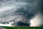
Spring is just around the corner and now is a good time to review severe weather safety and preparedness concepts before things start to get busy. I envision this thread as an ongoing learning resource that will extend throughout the entire severe weather season this year and serve as a ready reference for all members to review and contribute to.
Why am I doing this?
I both love and am humbled by severe weather. The entire science of severe weather is still evolving. The origination and evolution of many common weather events is still not fully understood by the scientific community. Individual observations and experiences add to overall knowledge base and continue to expand our knowledge of all things related to severe weather.
I’ve been an active NWS trained Advanced Severe Weather “Skywarn” Spotter for about fifteen years now. My interest in severe weather got me into Ham Radio and participation as an Amateur Radio Emergency Service (ARES) responder. I have also had formal training with DuPage County IL. Emergency Management and am certified in Tornado Shelter Survey and registered as an Advanced Severe Weather Spotter for the Multi-County Warning System in Illinois. I have also served as an Amateur Radio Net Control Operator for the 20 county Milwaukee/Sullivan NWS Office in SE/SC WI.
How is this relevant to the general membership here?
Of all of the threats to individual personal safety, severe weather actually is the most likely to impact each and every one of us at least once during our lifetime, often multiple times in our life. Flooding, hail, high winds, lightning, and tornados will find us at work, at home or during our many travels at some point in time.
Pre-event planning and education will make a significant contribution to mitigating the impact of these events.
First off, let’s go over a few essential basics. These are areas that everyone needs to know and to remain aware of during each and every severe weather season. Severe weather can strike with little or no warning at any time of day or night. Being prepared and “weather wise” will allow one to take the correct actions before, during, and after a severe weather event.
Watch: The WFO (Weather Forecast Office) issues a watch when conditions become favorable for the development of severe summer and winter weather. Stay alert to changing weather conditions, and listen for later forecasts and possible warnings. Examples of weather watches issued are: Tornado, Severe Thunderstorm, Flash Flood, Winter Storm and High Wind.
Warning: The WFO issues a warning when severe summer or winter weather is occurring, or is imminent. Take immediate action to protect yourself and loved ones! A warning means that loss of life or property is likely. Examples of the weather warnings issued are: Tornado, Severe Thunderstorm, Flash Flood, Winter Storm and High Wind.
To this day I still see people in the media mess up the terms Watch and Warning. Even the occasional TV meteorologist will slip up. It is vital to understand these two terms, so one can act in the proper fashion.
A Watch simply indicates that there is the potential for severe weather in and near the defined Watch “box” area. No more and no less should be derived when hearing a Watch being issued. A Watch is not a guarantee of severe weather at your location. A Watch does allow one to plan their activities with the realization that severe weather may occur later in the day. Watches are issued for a large multi-county region. Severe weather may still strike an isolated area that has not received a formal NWS Watch. Some weather events evolve too quickly or the area is too small to allow a formal NWS Watch to be issued.
A Warning indicates that severe weather is imminent or is occurring right now. NWS NEXRAD radar, public safety officials or trained spotters have observed conditions which meet severe weather criteria. People in the warned are need to take immediate action to protect life and property. Carefully note the starting time, location, speed and direction of travel of the warned severe weather event. Follow your previously established severe plan to seek shelter. Carefully listen to when the Warning is being terminated before leaving shelter.
Stay tuned for more and let’s has a safe severe weather season this year!
Why am I doing this?
I both love and am humbled by severe weather. The entire science of severe weather is still evolving. The origination and evolution of many common weather events is still not fully understood by the scientific community. Individual observations and experiences add to overall knowledge base and continue to expand our knowledge of all things related to severe weather.
I’ve been an active NWS trained Advanced Severe Weather “Skywarn” Spotter for about fifteen years now. My interest in severe weather got me into Ham Radio and participation as an Amateur Radio Emergency Service (ARES) responder. I have also had formal training with DuPage County IL. Emergency Management and am certified in Tornado Shelter Survey and registered as an Advanced Severe Weather Spotter for the Multi-County Warning System in Illinois. I have also served as an Amateur Radio Net Control Operator for the 20 county Milwaukee/Sullivan NWS Office in SE/SC WI.
How is this relevant to the general membership here?
Of all of the threats to individual personal safety, severe weather actually is the most likely to impact each and every one of us at least once during our lifetime, often multiple times in our life. Flooding, hail, high winds, lightning, and tornados will find us at work, at home or during our many travels at some point in time.
Pre-event planning and education will make a significant contribution to mitigating the impact of these events.
First off, let’s go over a few essential basics. These are areas that everyone needs to know and to remain aware of during each and every severe weather season. Severe weather can strike with little or no warning at any time of day or night. Being prepared and “weather wise” will allow one to take the correct actions before, during, and after a severe weather event.
Weather Definitions From NWS Milwaukee/Sullivan
Watch: The WFO (Weather Forecast Office) issues a watch when conditions become favorable for the development of severe summer and winter weather. Stay alert to changing weather conditions, and listen for later forecasts and possible warnings. Examples of weather watches issued are: Tornado, Severe Thunderstorm, Flash Flood, Winter Storm and High Wind.
Warning: The WFO issues a warning when severe summer or winter weather is occurring, or is imminent. Take immediate action to protect yourself and loved ones! A warning means that loss of life or property is likely. Examples of the weather warnings issued are: Tornado, Severe Thunderstorm, Flash Flood, Winter Storm and High Wind.
To this day I still see people in the media mess up the terms Watch and Warning. Even the occasional TV meteorologist will slip up. It is vital to understand these two terms, so one can act in the proper fashion.
A Watch simply indicates that there is the potential for severe weather in and near the defined Watch “box” area. No more and no less should be derived when hearing a Watch being issued. A Watch is not a guarantee of severe weather at your location. A Watch does allow one to plan their activities with the realization that severe weather may occur later in the day. Watches are issued for a large multi-county region. Severe weather may still strike an isolated area that has not received a formal NWS Watch. Some weather events evolve too quickly or the area is too small to allow a formal NWS Watch to be issued.
A Warning indicates that severe weather is imminent or is occurring right now. NWS NEXRAD radar, public safety officials or trained spotters have observed conditions which meet severe weather criteria. People in the warned are need to take immediate action to protect life and property. Carefully note the starting time, location, speed and direction of travel of the warned severe weather event. Follow your previously established severe plan to seek shelter. Carefully listen to when the Warning is being terminated before leaving shelter.
Stay tuned for more and let’s has a safe severe weather season this year!