WEATHER Section of Highway 1 washes out at Rat Creek on Big Sur Coast - California

packyderms_wife

Neither here nor there.
I got this off of facebook, I know there's been a lot of rain out west but yikes, didn't realize it was taking out highways and the like. I'll see if I can find a supporting article.

'There goes Highway 1 for the next few years !!!
1f641.png
(Rat Creek mile marker 33)'


144003640_1802426226589366_2841605501946748248_n.jpg
 

packyderms_wife

Neither here nor there.

Update: Section of Highway 1 washes out at Rat Creek on Big Sur Coast

Posted: 7:15 am, January 30, 2021 by News Staff
Update: Section of Highway 1 washes out at Rat Creek on Big Sur Coast

Update posted Jan. 30:

Highway 1 remains closed from Ragged Point to Fullers Point
–A debris flow from the hillside above Rat Creek on Highway 1 on the Big Sur coast overwhelmed drainage infrastructure, flowed across the highway, and eroded the road resulting in the complete loss of a segment of Highway 1 at that location, according to Caltrans.

Rat Creek is located at PM 30.2 and is two miles south of the Esalen Institute. It is about 1 mile south of the origin of the Dolan Fire in the Dolan Canyon area of Big Sur and is within the burn scar area.

On Thursday, Jan. 28, Caltrans crews, working from the north doing a post rainstorm assessment of the roadway, discovered debris flow across the highway at Rat Creek. Before dark on Thursday, the lane on the coast side of the road had washed out.

On Thursday evening, Caltrans entered into a $5 million emergency contract with Papich Construction of San Luis Obispo County to assist with the repair of the highway slide-out.

On Friday, Jan. 29, Caltrans assessment crews and emergency contractors arrived at daybreak to discover that both lanes of the highway had washed out.

At this point, the damage assessment team has not issued a report on today’s findings and will continue to work this weekend. The current closure of Highway 1 from Ragged Point to Fuller’s Point just south of Deetjen’s Big Sur remains in effect.

Businesses on Highway 1 from Carmel to Big Sur and south to the full closure remain open. Barricades, cones, as well as message and directional signs are in place at both ends of the closure to alert motorists traveling in the area.

Original story posted Jan. 29:

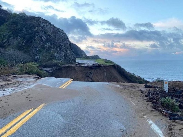
A chunk of Highway 1 collapses due to storm
highway-1-collapses-into-ocean-at-big-sur


Image from CHP Monterey Division.
State Route 1 closed through Big Sur

–The California Highway Patrol Monterey division shared a photo Thursday of a part of Highway 1 that had collapsed near Big Sur into the Pacific Ocean due to heavy rains.

The highway was washed away by debris flow near Rat Creek, which is about 30 miles north of the San Luis Obispo County line.

Caltrans closed much of the scenic roadway earlier in the week to prepared for the heavy rains. Caltrans is expected to be onsite today to assess the damage.

CHP Captain Kyle Foster said, “State Route 1 between MPM 40 and the San Luis Obispo county line continues to be impacted by inclement weather, debris flow, flooding, and slides. This area is closed to the public. Remain clear of the area and plan alternate routes. Please continue to exercise extreme caution on rural roads, especially at night. Please see Caltrans website for up-to-date information on road closures. Stay safe.”
 

packyderms_wife

Neither here nor there.
Hopefully some locals from that area can give us a better idea of what's going on.

I know my cousin marked herself safe yesterday after a wall of mud came down a block and a half from her house. It was an area called the "River Fire" that burnt a year or so ago. I posted a thread about the mudslide a couple of days ago here.


packyderms_wife

Neither here nor there.
That thing is HUGE !!

:shkr:

View attachment 249429


Yeah, and Hwy 1 is scary enough on a good day, I've driven it from someplace in northern Cali down to San Francisco and there were spots where it was one lane only, the other lane was in the ocean.

ETA it was Fort Bragg my bestie and I were there for a workshop. Slept in the Holiday Inn Express had a great view of the ocean.
 

vessie

Has No Life - Lives on TB
And of course I try to click on the pics to see if there are any dinosaur bones or Saber Tooth tiger fangs jutting out of the dirt wall. V
Packy, you and I both know that we would both be at the edge of that abyss looking for bones and artifacts! Lol! V
 

byronandkathy2003

Veteran Member
when did they change the highway number if i remember right that would be highway 101..
highway 1 is on the east cost it goes all the way down to key west
 

Millwright

Knuckle Dragger
_______________
when did they change the highway number if i remember right that would be highway 101..
highway 1 is on the east cost it goes all the way down to key west

From wiki

State Route 1 (SR 1) is a major north–south state highway that runs along most of the Pacific coastline of the U.S. state of California. At a total of just over 656 miles (1,056 km), it is the longest state route in California. SR 1 has several portions designated as either Pacific Coast Highway (PCH), Cabrillo Highway, Shoreline Highway, or Coast Highway. Its southern terminus is at Interstate 5 (I-5) near Dana Point in Orange County and its northern terminus is at U.S. Route 101 (US 101) near Leggett in Mendocino County. SR 1 also at times runs concurrently with US 101, most notably through a 54-mile (87 km) stretch in Ventura and Santa Barbara counties, and across the Golden Gate Bridge.
 

West

Senior
And of course I try to click on the pics to see if there are any dinosaur bones or Saber Tooth tiger fangs jutting out of the dirt wall. V

Well don't be silly.

However if this was a private property road, I could guarantee that after the mandated Environmental impact study is done before getting permitted to be repaired, the Yellow legged tree frog, or wild flowers would be found, and extra tons of monies and time would be needed to get the job done. Plus billions in lawyer fees.
 

West

Senior
They will first dig out even more and create a French drain type system and a culvert system. Then tons of huge rock base. Then gravels.

At least that's what I've seen in the past.
 

vessie

Has No Life - Lives on TB
Well don't be silly.

However if this was a private property road, I could guarantee that after the mandated Environmental impact study is done before getting permitted to be repaired, the Yellow legged tree frog, or wild flowers would be found, and extra tons of monies and time would be needed to get the job done. Plus billions in lawyer fees.
I was purposely being silly! Lol!

But still, if I was able to safely stand at the edge of that abyss, I'd have my binocs and would be looking for any artifacts and dinosaur bones sticking out.

Up in the Seattle area, you can find a Saber Tooth tiger bones and fangs hanging out from the cliff above Puget Sound, like what happened when part of Magnolia and some houses there fell into the sound,

Digging about 12 feet deep, Mammoth tusks have been found two times in the last several years, once when digging for redoing Juanita High School which is across Lake Washington, and also in the south part of Lake Union in Seattle when a builder was digging out a new foundation for a big high rise.

So, seeing the pic above of the highway, I'm naturally compelled to look for artifacts.

I don know that if a builder does find anything to do with Indian artifacts, and not many people know about it, they will bury that stuff up tout suite before the state finds out about it and shuts the whole work site down.

I heard this personally from builders. V
 

Kathy in FL

Administrator
_______________
Our honeymoon was driving the Coastal Hwy from San Fran down to San Diego. Hard to believe how much Cali has changed in only thirty-some odd years. Crazy, crazy.
 
Top