Jarhead
Has No Life - Lives on TB
Well, here we go....... 
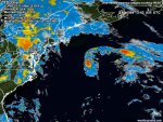
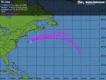
Disturbance 91L spins towards Cape Hatteras;
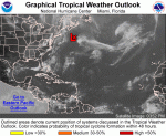
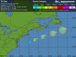
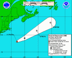
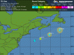
An area of disturbed weather, dubbed "91L" by the National Hurricane Center, is centered 120 miles south of Cape Hatteras, North Carolina.
While the storm does not have much in the way of heavy thunderstorm activity, it does have a well-developed circulation, and the spin of the system is readily apparent on long range radar animations out of Morehead City, North Carolina.
The disturbance is over waters of 25 - 26°C and has wind shear of 10 - 15 knots over it, and these conditions are marginally favorable for some slow development to occur until Thursday afternoon, when the system will begin moving over waters too cold to support tropical cyclone development.
The disturbance will track north or north-northeastward at 10 - 15 mph towards North Carolina's Outer Banks today, then get swept northeastwards out to sea on Thursday. It is unlikely that the disturbance has enough time to develop into a tropical depression, but an Air Force hurricane hunter flight is on call to investigate the system this afternoon, if necessary.
If the system does develop, the current location of the heaviest thunderstorm activity in a band well removed from the center suggests that 91L would be classified as a subtropical depression. The Outer Banks of North Carolina can expect 20 - 25 mph winds and heavy rain from this system tonight and Thursday morning.
In a Special Tropical Weather Outlook issued at 8am EDT this morning, NHC gave 91L a low (less than 30% chance) of developing into a tropical depression.
(Weather Underground)
Jarhead

Disturbance 91L spins towards Cape Hatteras;
An area of disturbed weather, dubbed "91L" by the National Hurricane Center, is centered 120 miles south of Cape Hatteras, North Carolina.
While the storm does not have much in the way of heavy thunderstorm activity, it does have a well-developed circulation, and the spin of the system is readily apparent on long range radar animations out of Morehead City, North Carolina.
The disturbance is over waters of 25 - 26°C and has wind shear of 10 - 15 knots over it, and these conditions are marginally favorable for some slow development to occur until Thursday afternoon, when the system will begin moving over waters too cold to support tropical cyclone development.
The disturbance will track north or north-northeastward at 10 - 15 mph towards North Carolina's Outer Banks today, then get swept northeastwards out to sea on Thursday. It is unlikely that the disturbance has enough time to develop into a tropical depression, but an Air Force hurricane hunter flight is on call to investigate the system this afternoon, if necessary.
If the system does develop, the current location of the heaviest thunderstorm activity in a band well removed from the center suggests that 91L would be classified as a subtropical depression. The Outer Banks of North Carolina can expect 20 - 25 mph winds and heavy rain from this system tonight and Thursday morning.
In a Special Tropical Weather Outlook issued at 8am EDT this morning, NHC gave 91L a low (less than 30% chance) of developing into a tropical depression.
(Weather Underground)
Jarhead
Attachments

Last edited:


")