
Heliobas Disciple
TB Fanatic

Changes You’ll See In Tropical Forecasts This Hurricane Season | Weather.com
Each year NOAA changes how it presents its forecasts. Here are a few differences you’ll see this year. - Articles from The Weather Channel | weather.com
Changes You’ll See In Tropical Forecasts This Hurricane Season
By Jonathan Belles
8 hours ago
At a Glance
- Forecasts for tropical disturbances will be issued up to seven days in advance.
- Invest tags will be used more publicly.
- Southern California could receive tropical storm or hurricane alerts.
With less than two months until the official start of Atlantic Basin hurricane season, NOAA and the National Hurricane Center (NHC) have released lists of product changes for the six-month period when hurricanes and tropical storms are most likely to develop.
This year heavily features better communication mechanisms for their forecasts, but there were also some enhancements and extensions of current forecasts.
Here’s a few of the changes you’ll see this season:
1. Tropical Weather Outlooks Extend To Seven Days
One of the first changes you'll notice this hurricane season is that the Tropical Weather Outlooks (TWO) will extend out to seven days this upcoming season instead of the past maximum of five days.These are the outlooks that highlight areas in yellow, orange and red that relate to the low, medium or high chance of development, respectively.
These outlooks discuss areas of disturbed tropical weather from Hawaii to Africa and everywhere in between. They also give the chance of development for each system four times each day beginning in mid-May.

Tropical Weather Outlook
(This is not a real forecast and is meant to be a sample only. )
The outlooks will be released at 2 a.m., 8 a.m., 2 p.m. and 8 p.m. ET from May 15 through Nov. 30.
These outlooks are being extended because in-house testing at the NHC suggest the longer outlooks are similarly reliable to the 2- and 5-day outlooks already being issued.
You can read more on these outlooks at the NHC’s page.
2. Outlooks Will Include Invest Numbers
For many years, the NHC and forecast centers around the world have used a system to refer to interesting tropical systems for investigation before they develop into a tropical depression or storm.
These systems, known as "invests," are increasingly becoming better-known in the media, so much so that the NHC will publicly recognize them in TWOs beginning this hurricane season.

Invests Explained
(Invests are disturbances tagged by the NHC to bring more focus to them and to open up resources to study them.)
Invests will be identified in a somewhat different manner than is typical. The identification will be composed of a two letter ocean identifier (AL: Atlantic; EP: Eastern Pacific; CP: Central Pacific) and a number in the 90s. The first such tagged system in the Atlantic will be Invest 90L and will be identified by the NHC this year as AL90. These systems will also be labeled with a geographic identifier such as the Gulf of Mexico or Eastern Tropical Atlantic.
(EXPLAINED: What Is An Invest?)
Systems are tagged as invests to run specialized hurricane models on, or to provide extra resources, such as the Hurricane Hunters or zoomed-in satellite floaters for monitoring of such systems.
3. Tropical Alerts Could Be Issued In Southern California
This is probably the most peculiar change on this year's list, but it is several years in the making.Starting this hurricane season, the National Weather Service offices in San Diego and Los Angeles will be able to issue tropical storm watch, tropical storm warning, hurricane watch or hurricane warning products for their areas. These products won't be different from the ones that residents along the Gulf Coast, the Atlantic seaboard or in Hawaii might be used to.

Tropical Alerts May Be Possible in Southern California
(These alerts are for display only and are not real alerts issued by the NOAA or TWC. )
In addition to those products, Hurricane Local Statements could also be issued. These statements offer a local discussion of potential threats, including storm surge, wind, flooding or tornadoes.
For meteorologists and climatologists, this change isn’t surprising.
The biggest reason that Southern California doesn't see tropical storms or hurricanes like, say, Florida or Texas, is that water in the Pacific is considerably cooler than in the Atlantic or Gulf of Mexico.
But waters in the Pacific, as elsewhere, are warming and the Pacific is slowly becoming more hospitable for tropical systems up to the latitude of the American coastline.

Water Temperatures and Typical Pacific Tracks
In 2022, the remnants of Hurricane Kay produced widespread flooding and debris flows in Southern California and the highest wind gust on record – 109 mph – for the region that NWS San Diego covers. At least one person was killed and dozens of homes were damaged by flooding.
Interestingly, this change could be implemented in the same year that the first blizzard warnings were issued in Southern California.
4. The Cone Of Uncertainty Is Updated
The cone of uncertainty refers to the projected path map you frequently see on the internet or television for a given storm.The annual update to the cone of uncertainty made the cone for 2023 roughly the same size as last year. At 120 hours' lead time, the cone did grow slightly from radii of 200 miles to 205 miles, or for a total of 410 miles across.
The cone is changed once a year, typically in the spring, as a result of the previous five hurricane seasons. The cone will not be adjusted again this year.
The cone of uncertainty does not change from one storm to another, but impacts from each storm can change drastically.

Cone of Uncertainty, 2022
The cone is made up of circles that encapsulate 67% of the historical forecast track errors over the last five years at each point from three to 120 hours.
It does not represent where impacts like surge, wind, flooding or tornadoes will occur. In fact, most impacts will fall outside the cone of uncertainty within a forecast out to a day or two.
Generally, this error has decreased over the last 10 years, but these errors have leveled off in more recent years.
Here are some other changes this season:
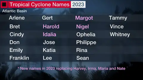
-Four new names will join the list this year: Harold, Idalia, Margot and Nigel. These names replace Harvey, Irma, Maria and Nate from the 2017 list.
-NOAA’s Weather Prediction Center will now issue discussions on inland tropical depressions and post-tropical systems.
-NWS offices along American coastlines will now host a new website after tropical systems pass their areas with reorganized stats on wind gusts, rainfall, pressure and impacts. A sample website is provided here.
-Storm surge flood potential graphics will be available this season for Puerto Rico and the U.S. Virgin Islands.
-The NHC’s experimental storm surge forecast graphic will be made operational. A sample of that product can be found here.
-Standard tropical storm and hurricane advisory graphics will be expanded to U.S. territories in the west and south Pacific.
Here are the names that will be given to the tropical storms and hurricanes that form in the Atlantic Basin this season:
Hurricane season isn’t far away. Educate yourself on what you need to know this hurricane season. Here's a reading list to get started:
Cone of Uncertainty: Facts And Myths About This Tropical Forecasting Tool
Hurricane Season Terms You Need To Know
Spaghetti Models: Four Things You Need To Know To Track Storms Like The Pros
What Is A Potential Tropical Cyclone?
Why The Projected Path For Hurricanes, Tropical Storms Doesn't Always Tell the Full Story
Four Things You May Not Know About Hurricane Forecasts
The Weather Company’s primary journalistic mission is to report on breaking weather news, the environment and the importance of science to our lives. This story does not necessarily represent the position of our parent company, IBM.