
Hfcomms
EN66iq
Really could of put this under tech but it also has a direct implication for prepping and considering perhaps our near to mid term future it can definitely be a prep item. Like most of us on TB2K we are information junkies and in the future information you can trust is going to be hard to come by especially if there is a grid down or Internet down scenario in our future.
The National Weather Service (NOAA) maintains a small fleet of weather satellites covering the US and territories and these are totally unencrypted and for less than $500 you can set up your own earthstation to download near real time images, graphics and emergency managers information using a Raspberrypi single board (cheap) computer and peripherals.
I will give some links for information and photos of my setup. In addition it is possible to run this totally without commercial power or Internet and even in a worst case scenario you can get up to date weather information along with EAS type messages that are going to work even if your local weather radio is offline.
The equipment required is a 2Ghz wifi dish, a LNA for the dish (low noise amplifier), a RTL-SDR dongle (Software Defined Radio) and a Raspberrypi single board computer running Linux setup for a headless environment meaning the little computer board stands alone and doesn't need to be hooked up to a keyboard or monitor once set up.
An additional piece of software (vitality-goes) can be set up on the Raspberrypi (also works on windows machines) to allow any of your wireless devices such as a tablet, notebook or even a phone to pull up the information and all the data/pictures off of your home network system.

This is the wifi dish and the white box has the LNA inside it. Nooelect sells a complete setup on Amazon which is where I got it. It includes the dish/antenna, the LNA, the RTL-SDR dongle and 10 meters of appropriate coax.

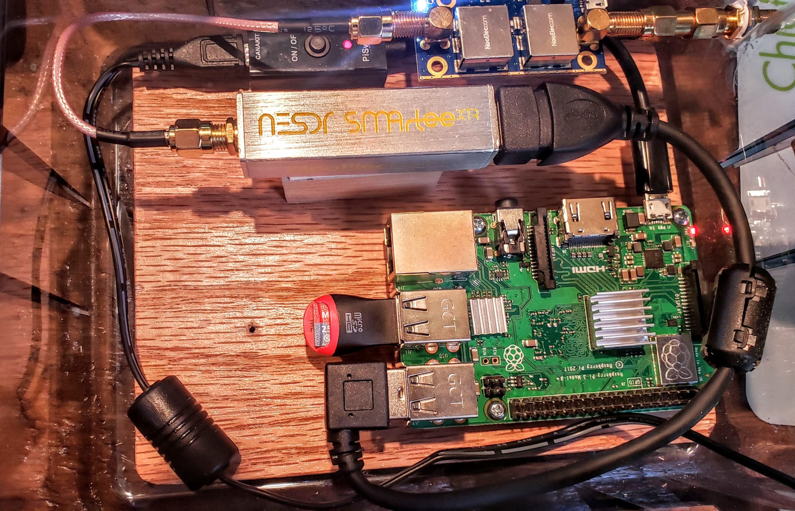
On the inside the coax is going from the wall to the RTL-SDR dongle which is plugged into the Raspberry pi. The ethernet cable is going to the home network switch (can use wifi) and the little box on the right converts DC power from the solar system or even a 12v battery to the 5 volts that the Raspberrypi uses to be able to power it regardless of commercial power. Here is the Raspberry setup that I bought;
OK, so what can you see with it?


The system is constantly downloading images directly from the satellite along with the EMWIN (emergency mangers weather information network) which handles all of your watches, warnings, emergency alert system info etc. There can be 30K text messages a day in that data stream. With the software setup (vitality-goes) on your raspberrypi you can set your location and the software will query the stream and just present the text data that interests you. Like in the picture directly above this you can see space weather alerts and on all the pages if you click on the arrows it opens up to the picture or graphic product you want to see.
If you are pointed at the east satellite it also includes pictures from the west satellite and vice versa along with relays from other weather satellites around the world.
In an emergency or just for day to day use you can have this near real time information at your fingertips and as I indicated before it can be set up to totally run off of battery power in case your commercial power goes down. A number of links below addressing this and how to set it all up.
 usradioguy.com

 github.com
View: https://www.youtube.com/watch?v=z5QSF7DCoV0
RT 22 min
View: https://www.youtube.com/watch?v=o5ISR0bBFo0
RT 2 min
View: https://www.youtube.com/watch?v=XMDAiUjzkhw
RT 10 minutes
The National Weather Service (NOAA) maintains a small fleet of weather satellites covering the US and territories and these are totally unencrypted and for less than $500 you can set up your own earthstation to download near real time images, graphics and emergency managers information using a Raspberrypi single board (cheap) computer and peripherals.
I will give some links for information and photos of my setup. In addition it is possible to run this totally without commercial power or Internet and even in a worst case scenario you can get up to date weather information along with EAS type messages that are going to work even if your local weather radio is offline.
The equipment required is a 2Ghz wifi dish, a LNA for the dish (low noise amplifier), a RTL-SDR dongle (Software Defined Radio) and a Raspberrypi single board computer running Linux setup for a headless environment meaning the little computer board stands alone and doesn't need to be hooked up to a keyboard or monitor once set up.
An additional piece of software (vitality-goes) can be set up on the Raspberrypi (also works on windows machines) to allow any of your wireless devices such as a tablet, notebook or even a phone to pull up the information and all the data/pictures off of your home network system.
This is the wifi dish and the white box has the LNA inside it. Nooelect sells a complete setup on Amazon which is where I got it. It includes the dish/antenna, the LNA, the RTL-SDR dongle and 10 meters of appropriate coax.
On the inside the coax is going from the wall to the RTL-SDR dongle which is plugged into the Raspberry pi. The ethernet cable is going to the home network switch (can use wifi) and the little box on the right converts DC power from the solar system or even a 12v battery to the 5 volts that the Raspberrypi uses to be able to power it regardless of commercial power. Here is the Raspberry setup that I bought;
OK, so what can you see with it?
The system is constantly downloading images directly from the satellite along with the EMWIN (emergency mangers weather information network) which handles all of your watches, warnings, emergency alert system info etc. There can be 30K text messages a day in that data stream. With the software setup (vitality-goes) on your raspberrypi you can set your location and the software will query the stream and just present the text data that interests you. Like in the picture directly above this you can see space weather alerts and on all the pages if you click on the arrows it opens up to the picture or graphic product you want to see.
If you are pointed at the east satellite it also includes pictures from the west satellite and vice versa along with relays from other weather satellites around the world.
In an emergency or just for day to day use you can have this near real time information at your fingertips and as I indicated before it can be set up to totally run off of battery power in case your commercial power goes down. A number of links below addressing this and how to set it all up.
Programming the PI for goestools operation - USRadioguy.com
How to program and Raspberry Pi for GOESTOOLS - Building and GOES Satellite Receiver.
usradioguy.com
RTL-SDR.COM GOES 16/17 and GK-2A Weather Satellite Reception Comprehensive Tutorial
GOES 16/17 and GK-2A are geosynchronous weather satellites that transmit high resolution weather images and data. In particular they are far enough away from the earth to be able to take beautiful 'full disk' images which show the entirety of one side of the Earth. As these satellites are in a...
www.rtl-sdr.com
GitHub - JVital2013/vitality-goes: Web App for showcasing Geostationary Weather Satellite Data
Web App for showcasing Geostationary Weather Satellite Data - JVital2013/vitality-goes
github.com
RT 22 min
RT 2 min
RT 10 minutes