Story Aunt Gus and Little Bear's Adventure Book 3 (Complete)

Kathy in FL

Administrator
_______________

Nov 2nd: Road to Hana Full Circle (Part 3)​


Kaumahina State Wayside (Mile Marker 12) - This state park is one of the first big stops on the Road to Hana. We all appreciated stretching our legs along the spacious 7.8 acres. One of the favorite aspects for most who stop here is the bathrooms! The smoothies had hit and everyone took their turn.

Honomanu Bay (Mile Marker 14) is a black sand bay of boulders that sits between the Garden of Eden Arboretum, where parts of the original Jurassic Park movie was shot, and the Ke’anae Peninsula—an ancient fishing village and still lush taro plantation that, with its 18th century coral-mortared church and coconut palms, evokes what we’ve come to imagine as Old Hawaii. A narrow, often-missed road took us across rough terrain to the rugged cove of Honomanu Bay. Our guide told us that while most 4X4s can navigate the road to the beach with relative ease, you can also park on the side of the highway and walk down the half mile. We took the 4x4.

This is the spiel the guide gave as we rode down: A favorite among fishermen, surfers and local families, Honomanu Bay epitomizes seclusion. It rests at the base of Honomanu Valley, a verdant expanse of volcanic wonder—and the second largest valley on Haleakala’s northern slopes—with rises that stretch 7,000 feet into the sky. The bay itself is enveloped by steep ridges, tucked between the bluffs like a secret. Overflow from Honomanu Falls—a 400-foot waterfall in the timberline above the cove—feeds the Honomanu Stream that runs perpendicular to the ocean. (Much of the water that gushes from the falls is diverted into ditches that supply water to other parts of the island.) The slopes above offer contemporary evidence of Maui’s earliest volcanic activity, an era known as Honomanu, in which a symmetrical shield was fashioned out of lava from Haleakala. Today, the jungles above the bay hold some of the oldest rocks on the island—geologic jewels that have endured subsequent eruptions. Swim with care if you choose to get more than your feet wet: the surf at Honomanu Bay can verge on the side of hazardous (with considerably strong riptides) and the bottom is notoriously rocky. Winter months are particularly precarious, when seasoned watermen take to the offshore breaks—some of which can reach up to twenty feet. The freshwater estuary on the mauka side of the beach is ideal for keiki, while bolder travelers can hike towards the valley to jump into the stream, parts of which reach eight feet deep. Know before you go: this bay offers neither restrooms nor lifeguards, and reception is generally nonexistent.

Bamboo Forest (used to be a stop decades ago but now illegal to trespass) – also known as Na’ili’ili Haele. It was (and is for those that trespass) the number one rescue required spot on the Hana Road. It was at one time very popular, too popular…there are many places to slip and potentially get injured. There are also many sad tales of broken legs, flash floods stranding people on the other side of the stream, and even death. The driver said if you want to keep your business license, you don’t stop. He did give me a postcard of the former trail and I could see why people would be enthralled by it.

Ke’anae Valley Peninsula (Mile Marker 16.5) - We were in the mood for another small hike by mile marker 16, Ke’anae Arboretum will take you past some unique Hawaiian flora for about half a mile.

Ke‘anae Point is a small Hawaiian village doing their best to live like the Hawaiians used to. Hunting pigs and growing taro, bread fruit, and Bananas are all big parts of everyday life in the small community. It’s also the site of the famous “Half Way to Hana” Snack stand; shave ice, fresh coconut, fresh pineapple in season, cold drinks and of course the Original Fresh Baked Banana Bread. In 1983, Aunty Sandy Hueu began to bake her famous banana bread in Keʻanae. In 2003, her daughter Tammy joined the business to create an authentic family owned and operated food stand on the Keʻanae peninsula. Since then, Aunty Sandy's has become a must stop destination for hot, fresh baked banana bread. The Ke’anae overlook and peninsula offer views of one of the largest taro farms in Hawaii. It was amazing what we got accomplished in thirty minutes and it included the Ke’anae Congregational Church and a lava tube that was in the area.

The following is a summation of what our guide told us because for the life of me I can't say it any better and have it make any kind of sense: Wailua Valley is an ahupuaʼa that sits just after the Keanae peninsula on the road to Hana. The area, though small, is rich in Hawaiian culture. It is here that an abundance of rare culturally significant fish and plant life can still be found. The area holds many ancient taro, or kalo, patches; a number of which are still in operation. In Hawaiian legend, taro is literally the older brother of all Hawaiians. And, so “Mahiʼaiʼana”, or cultivation of the land, is an ingrained principle that has endured for the people of Wailuanui.

It was here in 1778, anchored offshore in the Resolution, that Captain Cook and his crew were received by the people of Maui during his second and fatal voyage to the Hawaiian islands. With the arrival of Captain Cook, missionaries and developers soon followed changing the landscape and lifestyle of much of Hawaii. But, due to its inaccessibility, Wailua has been slower to change.

The Wailua - Keanae area receives 100 to over 300 inches of rainfall per year in the rainforest, and is the largest single source of surface water in the state. It is one of the few places in Hawaii that one can still catch oʼopu (Hawaiian stream gobies), opae (fresh water shrimp), hihiwai (Hawaiian stream snail). Oʼopu were once prized and used as a source of income for many fisherman in the area. However, with the diversion of the stream water to central Maui, many of these animals have become increasingly hard to find. The Oʼopu is now so scarce in Hawaii, that commercialized sale of the fish is banned.

Olona, the cordage fiber used in the famous Hawaiian feather capes and cloaks was also cultivated here up until the mid 1800ʼs. A member of the nettle family, this fiber was used for making fishing lines, fish net, koko or slings, and was a valuable trading commodity. This prize possession is so strong that it was passed down and used for multiple generations. However, the plant is finicky and can only grow in certain areas of Hawaii, making Wailua and nearby Keanae very respected areas.

Other plants that we saw growing throughout the area was colorful ti, croton, plumeria, ginger, heliconia, and ferns like hapuu. There were also a variety of trees and shrubs like coconut palms, mango, avocado, various types of citrus, banana, guava, Hawaiian noni, manila palm, gardenia, and an occasional rubber tree to name a few.

Before the Hana Belt Road, or Hana Highway was completed in 1926, the main modes of transportation to and from Wailua were footpaths, canoe, boat, or the Piilani trail. The completion of the Hana Highway finally allowed for easy access to a once very remote area, quickly adding new pressures and influences from the outside world. Only four years later, the 1930 directory showed that this was the first time that taro planters and homesteaders were outnumbered by wage laborers.

WWII definitely hit close to home when a Japanese submarine torpedoed a ship in the Alenuihaha Channel off Mauiʼs East coast, killing 29 people. Two caves were dug where explosives were stored; ready, should an invasion occur, to be used in the bombing and destroying of the Hana Highway. “Young men left their taro fields [to fight in the war] and many never came back,” one local resident remarked.


Saint Gabrielʼs Church and Our Lady of Fatima Shrine - located on Wailua Road, is a Catholic church that was built in 1860 out of white coral. Legend has it that it was dubbed the “miracle church” after a group of Protestants were selfishly hoarding the white coral for a church that they were building nearby. After a few strong storms, the sea had washed all the coral away from the Protestant area and left it all deposited on the Catholicʼs land. The white stucco walls are made of limestone with blue stenciling; and, there is a rare gambrel roof. (Wailua Road turnoff was on the left, just after mile marker #18)

Waikani Stream Bridge - (After mile marker #18) This has been called one of the most impressive bridges in Maui. Built in 1926, during the completion of the Hana Hwy, it is unique in that its structure type is a continuous concrete arch- deck. The single arch is 83 feet in length, and has a dramatic appearance. And trust me when I say it looks as old as it is, like it was crumbling before our eyes. The road wasn’t much better though our driver acted like that was normal. Ugh.

Traffic was crazy so the guys just took pictures from the 4x4. Waikani Falls - seen in the distance, mountainside, when standing along Wailua Road.

Wailua Valley State Wayside Park - Easy to miss, located just past mile marker #19 on the right-hand side of the road. There are stairs on the right, leading to a vantage point that provides views of Wailua Valley, Keanae Peninsula, distant waterfalls, and the Koolau Gap when facing inland.

Wailua Lookout - This was our last view of Wailua while heading into Hana. The pull off was on the lefthand side of the road, about a 1/4 mile past the Wailua Valley State Wayside Park. The lookout provided a spectacular view of Wailua village and the falls that the guys were quick to get on film. Wailua Falls is perhaps the tallest roadside waterfall on the Hana Highway. This is the most popular waterfall and most congested in the immediate area. For everyone’s safety we didn’t get out of the vehicle; our driver passed by it slowly so the guys could get things on film. There were really any safe parking spaces available.

Upper Waikani Falls (Mile marker 19.5) – According to our guide these are also known as “Three Bears Falls.” [Benny loved the name.] This trio of waterfalls come together to form the perfect little grotto peaking at 70-feet tall and cascading into Wailua Nui Stream below. There isn’t a ton of parking near the falls, so some drivers choose to park further ahead about a tenth of a mile and walk across the bridge to see them. Upper Waikani Falls cascades from a height of seventy feet to Wailua Nui Stream down below, its splash alone makes for a great photograph.

Underneath the bridge on the makai—or ocean side—of Hana Highway, was a moderate trail that will led to the fall’s crystalline waters. The steep start is admittedly a touch of a challenge but the path levels off for easy hiking (with just a touch of some rock scrambling). Part of the foliage that surrounds the falls is red torch ginger; it also grows well in South Florida which is why I recognized it. There was also ti, croton, and ferns, including the native hapu’u—a historically significant, velvety plant that was commercially used in the 1800s to stuff pillows.
 

Kathy in FL

Administrator
_______________

Nov 2nd: Road to Hana Full Circle (Part 4)​


Pua'a Ka'a State Park (P) - (Mile Marker 22.5) - Our guide told us that this little park is one of the best on Maui, and not just because it has one of the only restrooms along the Road to Hana. There are picnic tables, an easy hiking trail, and an accessible waterfall inside this park as well. We musn’t forget the cats that seemed to drape themselves everywhere either. It is fairly easy to access the waterfall from there. Some people like to take a dip in the chilly waters by the waterfall on a hot day. Benny and I played prop for the guys but thankfully I had towels and dry clothes for us to change into.

Hanawi Falls (Mile Marker 24) – according to what I read while waiting in the airport the other morning, one of Hana’s most cherished and spectacular spots is Hanawi Falls. Located right after mile marker 24. Water at the lower falls cascades from a height of two hundred feet, rainforests “glisten in the oft-seen rain”, and the Pacific booms and beckons just below (the advertisement really said it just like that). Hanawi Falls—whose Hawaiian translation remains unknown—is sustained by the Hanawi Stream, a spring-fed river that tracks into the ocean nine miles downslope. One of the best places to view these falls is from the Hanawi Bridge, and there are a couple of narrow pull-outs both before and after to park and get out. It was a little harry to get out and get the pictures but there were harrier spots to come.

The view may be astounding, but the water itself is something astounding as well. Surrounded by rainforest and copses of hala—a culturally significant tree distinguishable by its pineapple-shaped fruit—Hanawi Stream is part of a larger system, where 450 million gallons of rain per day empty into the tunnels and ditches of the East Maui Irrigation Co. Water pours into the ocean as well. Hanawi Stream also houses Megalagrion pacificum, an endangered damselfly that’s endemic to the marshes and freshwaters of Hawaii, and feeds plants that range from white ginger and koa to ‘ohia lehua and sandalwood. According to our guide: Deemed one of the most pristine streams in the state of Hawaii, it flows down into the village of Nahiku. Known by some as the former home of Beatles member George Harrison, the remote outpost is dominated by the sight of rubber trees—the result of an effort from 1905, when 25,000 Hevea brasiliensis were planted by the Nahiku Rubber Company to fill the nation’s growing need for tires. While the rubber plantation temporarily succeeded as the first of its kind in North America (Hawaii, at the time, was a U.S. territory), disappointing returns forced the company into closure in 1912. Years later, 40 prisoners incarcerated at the Ke’anae Prison Camp nearby were sent to Nahiku to revive the trees, but the plan ultimately failed—leaving behind a gift for us today in the giant, gorgeous rubber trees that line the area.

Nahiku Marketplace (Mile Marker 29) - A fun stop to find a variety of food options, this marketplace sells everything from Thai food and tacos to coffee and seafood. I think the guys tried to sample as much of it as they could. Lev has indigestion tonight so I suspect he snuck in a little gluten, or there was some cross contamination or something. I’m not going to beat him over the head about it. He’s a big boy. Hopefully he learned his lesson.

The real beauty for some people are the bathrooms, despite them being just port-o-johns. Of course the women’s bathrooms had the longest lines and despite trying to be as fast as possible the guys had bought a bunch of food – thankfully most of it fresh rather than junk. They insisted on feeding our driver and guide much to those two men’s appreciation. The low-key options included Nahiku Café, Island Chef, Island Style Tacos, Hana Highway Sorbet, My Thai, and a couple of local vendors.

Kahanu Garden and Pi'ilanihale Heiau (Mile Marker 31) - This garden is home to the largest heiau (religious structure) in Polynesia, dating back to the 16th century. There was also a “plethora” (thesaurus word of the day) of Hawaiian tropical plants, fruits, and vegetables inside the botanical garden. Part of the National Tropical Botanical Garden, Kahanu Garden is named after Chief Kahanu who owned this sacred land in the 1800's. Formerly used as a sugar plantation and pastures for grazing cattle, in 1974, the descendants of Chief Kahanu and Hana Ranch donated the first 61 acres to establish the garden, which today takes up 484 acres of natural Hawaiian beauty, history and culture. When the Polynesian settlers first came to Hawai'i in their canoes almost 1,800 year ago, they brought many ethnobotanical plants with them. These plants are found today in the "Canoe Garden" collections of Kahanu Garden. From 300 varieties of taro to 120 varieties of breadfruit, this wonderfully maintained garden was about more than just good looks. The culture and history that comes with these plants connects it to old Hawai'i.

Kaeleku Cave (Mile Marker 31) - Also known as the Hana Lava Tube, this stop was one of the most unique. It was a long lava tube at a third of a mile in length. There was also a ti leaf maze. A little touristy but still different and therefore Benny thought it was fun.

Waianapanapa State Park - Black Sand Beach, Sea Cave, & Blow Hole (Mile Marker 32) - Wainapanapa is Maui’s famous Black Sand Beach. Okay stop. I just gotta say I love that word. The first really Hawaiian word I could say without six tries and fails. It just kinda flows. Okay, back to what our guide told us. This location is a great place to spend an hour relaxing. Well I did, the guys and Benny ran around like crazy chickens let loose from a too small coop. The hamster was in Heaven, I kid you not. There were fresh water caves and lava tubes. Listening to the legend of Princess Popoalaea[1]. And learning how some times during the year these little shrimp are so plentiful and common they turn the water red.

We finally made it to Hana Town (Mile Marker 34). It was a small town and there are a few BnB’s there for people to stay at but you have to get reservations well ahead of time. Maybe another time … if the fantasy ever comes true that Lev and I come back on our own … but we had to keep going. After … ahhh! … more food.

Monday - Friday is Tahitian BBQ at local favorite Braddah's Hutts with 9 choices and Sat & Sun is Hawaiian BBQ with 4 choices. Vegetarians and gluten-free eaters can be accommodated (vegans might want to consider bringing own food). During the week, the vegetarian option is veggie pasta, mac salad, and rice; on the weekend, it's veggie pattie, corn, rice, and salad. For gluten-free eaters, the main protein and rice would be fine, but the side mac salad has to be skipped.

Pipiwai Trail (Mile Marker 41.5) We tackled this 4-mile hike through a bamboo forest and tropical rainforest within the Kipahulu section of Haleakala National Park. The reward at the end is the 400-foot Waimoku Falls, said to be one of the most epic waterfalls on Maui by far. Our guide said we would need to hustle because there was a bunch of other stuff still to go and we might end up losing daylight.

Wailua Falls (Mile Marker 44.8) Besides the view of a gorgeous waterfall tucked away into the jungle here, there was also plenty of parking beside this waterfall—a rarity along the Hana Highway.

Hamoa Beach (Mile Marker 50) - Consistently named one of the best beaches on the island, Hamoa Beach is what you think of when you imagine a secluded Maui beach. Famous for snorkeling during calm weather (which we didn’t have) and bodyboarding when the surf is high (which it was), Hamoa required a bit of a detour (by way of five minutes), but it was worth every second even if we weren’t doing the body surfing. The beach comes with the added perk of public bathrooms and showers, which is a luxury most Maui beaches don't come with. There were no lifeguards on duty, so basically you're responsible for the safety of your family and yourself. The sand at Hamoa Beach is what dreams are made of. This silky sand ran into the ocean, which meant we weren’t walking on volcanic rock or knife-sharp coral.

Koki Beach (Mile Marker 51) – is a mixture of red, black, and white sand. The dark red sand at Kōkī Beach was produced by the nearby cinder cone hill of Ka Iwi O Pele, meaning “bones of Pele.” According to Hawaiian legend, Kōkī Beach is where the volcano goddess Pele fought her final battle with her older sister, Namakaokaha’i, the goddess of the ocean. Pele’s bones were stacked along the Kōkī shoreline and her spirit traveled to Kilauea on the Big Island. Our guide didn’t recommend swimming here as the riptides can be “gnarly.” I’m not kidding, that is exactly the word he used. This is a surfing beach, not one for casual swimming.

Mile Markers start reversing at this point.


[1] The Legend of the Wai'anapanapa Caves - Maui Guidebook
 

Kathy in FL

Administrator
_______________

Nov 2nd: Road to Hana Full Circle (Part 5)​

Wailua Falls (Mile Marker 45) - is a very accessible waterfall visible from The Hana Highway. You don't even need to get out of your car to see it so that’s what we did … stayed in the 4x4. Located on Honolewa Stream (not Wailua Stream), it is supposedly Maui's 'most photographed waterfall'.

Ohe'o Gulch (aka, the Seven Sacred Pools) – Kipahulu is part of Haleakala National Park, one you cannot reach except by the Hana Hwy. We drove over Oheo bridge and were able to see the Seven Sacred Pools. Years ago you could swim in the pools but you can’t any more. Good reason for it though people try and do it anyway until the rangers come to tell them get out. There were a lot of deaths that were a result of debris from upstream being washed over and into the pools while people were swimming. At different times they’ve fenced off the pools or closed the trail up to the pool. Shame but I understand why they did it.

There are legends in the area that our guide told us as we drove: It is said that the fire goddess, Pele, chased Kamapua'a, the pig god, to this area. It is also said that Kipahulu was the home of a legend about The Love-Snatching Wind of Kipahulu. In this story, a woman from Kipahulu left her husband and children for a man from O'ahu. In her husband's grief, he visited a kahuna that was well-versed in "Hana Aloha Sorcery", which was a sorcery of love. The Kahuna had the man speak and blow into a shell that was then wrapped up and thrown into the sea. It eventually found it's way to Kalia, Oahu, where the woman came upon it. She opened it and was reminded of her love for Kipahulu and her family. Home-sick, she returned to her family.

Talk about your unexpected out in the middle of nowhere. Charles Lindbergh's Grave (Mile Marker 41) - Palapala Ho'omau Church was built in 1857 and still stands along Maui's coastline. It is famously known as the burial ground of famous aviator, inventor, explorer, author and activist Charles Lindbergh. Forty-one years after his non-stop solo flight across the Atlantic Ocean in 1927, Charles moved to Maui and settled in the remote area of Kipahulu, seeking privacy. After being diagnosed with cancer in 1974, he decided to live out his final days on Maui. The grave of both Lindberg and his wife is under the shade of a Java plum tree at the limestone coral church.

We were finally able to pick up speed and really didn't stop from that point onward.

Drive passed Laulima Farms (Mile Marker 42) – 13 acres brimming with organic fruits, vegetables, coffee, and herbs, including arugula, bananas, turmeric, cacao, and coconut.

Kaupo Ranchlands – Mile Marker 35 along Hwy 31 – This started what is known as the backside of Hana. It was like a different world. There was a store there that was about to close, but they let us buy some cold drinks to keep us going the rest of the way.

Maui's Last Lava Flows - Manawainui Gulch is Hawaiian ruins, jagged lava rocks, and mile after mile of wild, uninhabited country. This is considered the backside of Haleakala.

It was dark by the time we reached the condo and I think everyone was ready to get off the road. I held back and made sure the guide and driver got a good tip but they shook their heads. Bob had taken care of it in advance.

Lev must have turned around and found Benny and I weren’t there and he came back out while Diego and Chan went up. “I forgot to tip them. Did you?”

I answered, “I tried but Bob had already taken care of it.”

“Whew. Thanks for thinking. Er … have you got the leftovers?”

I laughed. “Are you telling me you’re still hungry?!”

“Eh … just don’t want ‘em to go to waste.”

Sure. That was the story and he was sticking to it. But I handed them over and he and Benny split them. Everyone had their turns in the shower and pretty much fell like a ton of bricks afterwards. Lev was going to try and package some things up but he just couldn’t pull it off. He was too tired and he said it would reflect in his work. They’ll have to do it tomorrow or at some point the day after though how they are going to find the time I don’t know. We’ve got a couple of more busy days ahead of us.

Resources:
BRADDAH HUTTS BBQ GRILL
View: https://youtu.be/bwpBY6-XcV4
(Pipiwai Trail)
Home | MauiWine - Ulupalakua Vineyards
Harold Rice Park, Maui County
 

Kathy in FL

Administrator
_______________

Nov 3rd: Workday​


Well, the Director and Producer are calling the shots. The only work today was getting some film ready and uploaded to the drop box. Maybe good for them but Benny and I were stir crazy for a bit. The pool wasn’t even open because the pump was being worked on and then they couldn’t open it until they put in a bunch of chemicals. I was about to just start walking but Lev asked if I would go over the coming days’ itinerary and try and pencil in some things.

Fine. I spent most of the rest of our waking hours doing that and exercising when the hamster was getting to be too much. Benny did a few “school” things, had a gab-fest with The Crew which had been feeling a little forgotten about, and then drew using the few art supplies I could come up with, mostly hotel pens and pencils and my scratch pad.

We have to go to bed early anyway as our day tomorrow starts at oh two crazy o’clock in the morning.

We wound up having to turn the tv off because of the election day insanity. There was some here on the islands but not too bad. On the Mainland it was another story. Lots of rioting on both sides being provoked by special interest groups with lots of old money and new, some of it from overseas, to back up their actions and activities. The same thing has happened before but you always hope that it won’t happen again. Ha!

Lev doesn’t know it but I’ve made a couple of shivs using junk left here in the condo that housekeeping didn’t take care of. Maybe I’m being a little paranoid, but I don’t ever want to feel as unprepared as I did at Pearl. Never again.
 
Last edited:

Kathy in FL

Administrator
_______________

Nov 4th: Haleakala National Park​


If you’ve ever had a kid go to sleep on you, you know it is like being sat on by a baby elephant. It is a thing to endure because you care about them, not because it is cute or anything. Especially if they drool on you. Oh yeah, that’s sweet right there. Not.

Our day started at 2 am and with just enough time to dress and get downstairs to be picked up by a driver who dropped up off within sight of our next pick up point. Supposedly the drive through the Kula District had been “scenic” but since it was dark I’m not sure how anyone noticed.

Arriving at the Haleakala National Park, we got inline to get in a by minibus up Haleakala to 9,740 feet elevation to the Visitor Center. It was still dark. And colder than I expected up there. Glad I pulled a just-in-case and had the three of us layered up. Diego and Chan had brought wind breakers.

I finally got to see Maui’s rare and endemic silversword plants that bloom once, then die. Well, see them at that point was kinda not true. I saw them but not very well. Besides we were looking for a spot to watch the sunrise[1] from the Visitor Center area which is what we hauled our butts all that way for. We’d already had to go through the reservation process and paid the fee for that plus the fee for entering the park. No way was I going to be looking at the ground and miss it.

As the sun started to rise, the views from Haleakala were nothing short of spectacular. Benny and I have seen some incredible things, but we can now say … all of us can say … that we saw the sunrise over the lip of a volcano. How cool is that?!

According to a sign-thingie in the visitor center, the writer Mark Twain, upon visiting the peak in 1866, wrote that the volcano was “the most sublime spectacle I ever witnessed and the memory of it will remain with me always.” I feel the same way. Well, maybe not sublime, but I’ll certainly never forget it. And Lev got the moneyshot. He is sending a copy of it to Bob, but he’s keeping one for us. Diego got it on film as well. Wow. The first rays of the new day slowly crept across the horizon. Soon the sky filled with a majestic glow, like how I imagine Heaven must look all the time. The beams of light then crept across the island of Maui, lighting up the land below. It affected me almost as much as seeing the northern lights in Alaska only this time it was like … like … it’s hard to explain. It was like as the sunrose it also rose inside me. Corny huh. And I’m not sure I can explain it anymore than I can explain how and why the northern lights affected me. All I can say is that it did.

I handed out the meal bars once the crowd started dispersing. Most were going off to hit up a restaurant for breakfast but some of us were staying up on Haleakala to explore the site and take in more of its stunning views.

We had gone over our plans and decided on the Keoneheehee Trail, aka Sliding Sands Trail. It was going to be a 5-mile round trip, strenuous hike, but we kept reading that the effort was more than rewarded and looking back on it I certainly agree.

The Keoneheehee (Sliding Sands) Trail starts at the bulletin board by the entrance to the Haleakala Visitor Center parking lot. We took the recommended path for the first 2.5 miles of the trail to the Ka Lu'u o ka O'o cinder cone before turning around and taking the trail back out. The round trip is a 5-mile trek, but given the elevation it felt longer. The final climb back up Haleakala's crater rim was also more than enough hike for one day. The total elevation gain/loss between the trailhead and the cinder cone was approximately 1,400 feet. The guys carrying all their equipment really felt it. It did Benny in and I’m glad we hadn’t pushed ourselves any harder.

I know we are going back again in about a week so I’m not disappointed. We were all beat from the early hour, the hike, and the high elevation. We met our driver in the parking lot and were lucky that he hadn’t had any problems getting up there. Ever since the big fire back in ’23 and the homeless riots of the 30’s, the national park has been forced to be even stricter in Hawaii than back on the mainland. They weren’t even this strict back in Alaska.

Before we left I did manage to get Benny in to get his Junior Ranger packet. He fell asleep while drawing a Nene (some kind of bird) but he’ll be able to turn it in when we go there next time. It kept him from being frantic.

When we left we passed by Makawao, described the driver as a quaint town with miles of greenery. We also got more views of Kula, this time during the day instead of evening like when we were finishing the Backside of Hana.

Got a nice surprise. I didn’t have to cook because we stopped at the Kula Lodge Restaurant[2] to enjoy a local-style, sit down lunch on the slopes of Haleakala. And they were expecting us. Bob strikes again. I had a chicken sandwich with dried banana crust and mango chutney curry. I left the bun on. Benny had the same thing sans the bun. We were fine with that but the guys all needed more to fill their tanks. Lev had mango bbq ribs with rice. Diego had a Korean style bbq plate. And Chan had … yep … fish and chips. The staff were really fast and understood gluten-free which is about as much as anyone can hope for.

Since our day started so early, we were back to the hotel early. Bob the All-Knowing said that the Director and Producer wanted content asap. I wanted to have a pithy comment given how much had been packaged up for them yesterday but they may be my monkeys, but it wasn’t my circus so I left the room to take care of my responsibilities. Benny was ready to crash and burn. I was tempted to lay down with him but I really had some adulting to do and though Lev offered to keep an eye on Benny so I could go down to the pool I opted to just take my stuff out onto the balcony and work there.

I wrote the Hana blog up in pieces so it would be more than one post. Organized my notes from today. Took care of yet more legal correspondence. Uncle Daniel is trying to nickel and dime the Estate and it may have to go to court unless he can be convinced in some way just to cut his losses and move on. Also had to answer a set of questions from some admin type at the Florida Bar regarding Sharon’s soon to be ex-husband. Man, she marries them and dumps them fast. I then fixed “lunch #2” though it was more like a platter of appetizers so the guys could eat and work at the same time. Benny woke up from his “nap” with the wiggles so I took him down to the pool for a while, and then came back to the room and moved from the balcony to the bedroom so Benny would have company while he played.

I was getting restless but that’s just the way things were today. Hawaii was just outside but I could only look at it. And just to make sure that the brain hamster continued to dance but not to the point of joining a mariachi band, I started a new inventory spread sheet trying to figure out how much food I would need to feed the three of us for a month at a time once we returned to the River House. To that end I also started looking for new gluten-free recipes that used long term storage type foods or would use the stuff that we are sending to Lev’s drop point.

I was about to get up and check on the guys when I heard the phone go off in the kitchenette and rushed out to answer it so the guys weren’t disturbed. It is the concierge desk saying our food order was at the desk.

I turned to Lev and said, “I hate to bother …”

“Is it downstairs?” Lev asked.

“A food order is. Yeah.”

Chan volunteered to go pick it up but I said that Benny and I would which they seemed thankful for. Found out they were really on a roll and had nearly twice what they’d expected to get done and wanted to keep going for as long as their energy held out.

It was Chinese … Hawaiian Chinese. And it was to give me a night off cooking. I was not saying no to that but O.M.G. those guys can put away some food. There were no leftovers despite the fact that I stopped counting the cartons as I was taking them out of all three bags. And no, I’m not exaggerating. I saw Diego grab the receipt so I’m pretty sure I don’t want to know how much the bill came out to.

They are still going at it though it looks like they are winding it down. They sure seem happy with the day’s results. I’m glad.

Resources:
Be A Junior Ranger - Haleakalā National Park (U.S. National Park Service) (nps.gov)


[1] https://www.gohawaii.com/content/haleakala-sunrise-sunset
[2] Kula Lodge Restaurant & Bar | Fine Dining Upcountry Maui
 
Last edited:

Kathy in FL

Administrator
_______________

Nov 5th: West Maui​


This was another early morning. Not O Dark 30 early but we were at the first trail at 6 am so early enough. We also stopped and picked up several gallons of water to refill our Nalgeen containers first thing as well. Three trails and a beach. Yeah. I don’t care if it is November, we were going to need more than a liter of water.

As a matter of fact, for the Waihee Ridge Trail we each started with three liters. I carried five – three for me and two for Benny – and Benny carried one in his own backpack. I also carried several snacks because I’d already gotten side eye from Diego daring me to have a thing to say about anything before he got a cup of coffee in him. It actually took three, more than usual. Something is bothering him but I’m not sure what. He isn’t my man to take care of and I’m not his momma either. But I’m not interested in having to scrape him off the ground if his glucose tanks. When he wasn’t looking I slid a couple of packets of almonds towards Chan and I threw two small cans of apple juice in my pack with the other stuff. It was only first aid junk after all.

When we got to the trailhead … er … I wasn’t impressed. It was just a small parking lot next to a gate and seemed mostly open ground. On the other hand our guide told me that Waiheʻe Ridge is one of the best trails on Maui to find native Hawaiian plants once you’re above the lower Eucalyptus forest. To name a few, we saw ʻŌhiʻa, Naupaka, Hōʻawa, and Kāmakahala. For that I was willing to give it a try and a decent attitude. The first part of the hike climbed up a steep utility road before branching off on the actual trail. The trail then comes to a fence which is the start of the switchbacks through the Cook Pine, Eucalyptus, and Strawberry Guava forest. If you don’t know, Strawberry Guava is also call Cattley Guava or Cherry Guava. Stella had one in her backyard and I learned to like the taste. You’ll never find them in the grocery store, they aren’t a commercial fruit, but they have a nice taste and they smell good too. As we continued the trail got more interesting … and strenuous due to the constant increase in elevation.

There was a nice viewpoint for Makamaka’ole Falls where we could take a break. The first 0.8 miles to the first platform should be considered the easy half of Waiheʻe Ridge. It’s the remaining 1.4 miles to the summit of Puʻu Lanilili that gets a bit more challenging. The first platform we came to is a popular end destination for many hikers. However, we came prepared to hike to the summit so that is what we did. Shortly after the first platform, Waiheʻe Ridge begins ascending a series of switchbacks up to a flatter meadow just below the summit. After the meadow, which may be very muddy, trail climbs a few more switchbacks that lead up to the summit. The switchbacks were a slog – especially for the guys with their equipment – but it was all worth it. The summit of the Waiheʻe Ridge Trail (Puʻu Lanilili) is about 2,563 ft. or about halfway up the west Maui mountains (Puʻu Kukui).

Well yeah, coming down was easier but it also gave me the energy to notice how muddy we’d gotten. We knocked the mud off our hikers the best we could and then we put on “slippas” (flip flops) as they are called in this part of the world and put our hikers in bags to keep the mud out of our guide’s car. The guys were really chugging the water so I’m glad we’d picked up the extra. The trail was just under five miles but it took us four hours to do it. I’m glad we got there early for that reason alone but by the time we left the trail was getting crazy busy and everyone wanted to know if they could have our parking spot. Oh brother.

Our next trail wasn’t as strenuous but it wasn’t easy either, more moderate, but it has a strange name of “13 Crossings Trail”. This hike follows the Makamakaole Stream, leading to two waterfalls.

Hmm. Why did I like this trail? The hamster isn’t being snarky, I really did like it. First, as it is through a forest and has great shade cover, perfect for the time of day we were hitting it. Next, 13 Crossings is relatively flat. While it was still challenging with some fancy footwork, it didn’t leave our crew breathless like the previous hike had. That was good for Benny who I didn’t want to push too hard regardless of all the get up and go he has. Lastly, this hike had more points of interest that our first hike even if there wasn’t a viewpoint that went to the ocean. From the sound of the stream, to the bamboo forest, to what may have been a heiau, to the waterfalls, there was a lot to take in and keep your mind off the distance which was four miles round trip but it still took us three hours with all the stops to photo and film.

What I didn’t enjoy? The bugs. The repellent I had chosen to replace some that I’d run out of was not the best in the world and it sweated off way to easy. I had deet on our clothes that helped some, but I could have used some in the cup of my ears to keep the blasted dive bombers at bay. I was glad to get back to the vehicle only for that reason. I still don’t think it has “13 crossings” but it came close. We had to hop across the stream quite a bit in two miles. Trying to keep Benny from falling in when he landed on a slick part of a stepping stone, one of my feet went in. I squelched the remainder of the day.

The guy’s stomachs were starting to register on the Richter Scale and a snack bag of trail mix wasn’t going to cut it. Our guide promised us good and local and took us to this place called the Saigon Café. It was a Vietnamese restaurant. I got another “look” from Diego. Basically he was telling me to shut up and not fuss which I suppose was a reference to the prices. Who said I was going to say anything?! Lev didn’t see it, but I got the message, or part of it. I have no idea what Diego’s sudden change in attitude is about. I let Lev order since he was familiar with the options. I wouldn’t let him order me much because I’d lost my appetite. He and Benny split something called Com Suon Nuong which is a Vietnamese pork chop rice plate served family style. I ignored what Diego and Chan ate, in fact ignored Diego completely, or as much as I could get away without being rude in front of Benny and Lev. He kept trying to poke the Gus and I was just not going to let him push my buttons.

Last trail of the day was a repeat from the first day; Kapalua Coastal Trail. Mr. Director needed a few more shots from some different angles and this was our only day to go back and get them. The some time on Kapalua Bay Beach. We are back in the condo and the guys are working away happily. I’m glad I didn’t have the attitude I could have. Makes me feel like I won over whatever battle Diego was trying to have. He gave it up after he ate lunch so maybe it was just his stupid hangries he gets. Whatever.

Time to get off this log and get some adulting done. I also need to see if the clothes are ready to move from the washer to the dryer. Man were we dirty when we came in.
 

Kathy in FL

Administrator
_______________
I wonder how much of Maui that you are describing for us is still there.... :shk:

Most of it but Lahaina. That I am having to rewrite to reflect things. Either that or I may leave it out. I remember the banyan tree and it is just about killing me to think that huge old thing is gone. It covered so much ground.

We have a few such banyan trees here in Florida. There's one at the Thomas Edison place and there's another at the Ringling Museum grounds in Sarasota. There's a few others that dot here and there but nothing like the one in Lahaina. I'm no tree hugger but :cry::cry::cry:
 
Last edited:

sssarawolf

Has No Life - Lives on TB
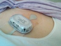
Really tired, but the thing is stuck on my upper chest. She used sand paper like stuff to rough up my skin to make the monitor stick better. My that made the skin sore. Can't get it wet but I can cover it with taped on plastic wrap lol.
Thanks for asking.10 aug 23 heart monitor Sally.jpg
 
Last edited:

Kathy in FL

Administrator
_______________
Really tired, but the thing is stuck on my upper chest. She used sand paper like stuff to rough up my skin to make the monitor stick better. My that made the skin sore. Can't get it wet but I can cover it with taped on plastic wrap lol.
Thanks for asking.

Oh Sweety, I'm so sorry. I was in ecstasy when I finally got the wound vac off but I'll be darned if I'm not ready to complain again about this blasted wound. I am so tired of it being sore and all the wound stuff on it. There's no sleeping on that spot that's for sure.

Just take care. We need you. I need you. You are a good and faithful friend.
 

sssarawolf

Has No Life - Lives on TB
Oh Sweety, I'm so sorry. I was in ecstasy when I finally got the wound vac off but I'll be darned if I'm not ready to complain again about this blasted wound. I am so tired of it being sore and all the wound stuff on it. There's no sleeping on that spot that's for sure.

Just take care. We need you. I need you. You are a good and faithful friend.
Hope yo can find something that will help that heal p faster than it is. I am sure yo are darn tired of it being so sore. :(
 

Kathy in FL

Administrator
_______________
Hope yo can find something that will help that heal p faster than it is. I am sure yo are darn tired of it being so sore. :(

They've decided that the medi-honey isn't working and are going to start using something called Silver Algenate (something like that). I know my dad used it at one point for one of his surgical scars and it worked well for him. My skin takes after his so I'm hoping I get the same results. I'm fairly certain, assuming I can avoid it, I am not going to opt for plastic surgery. It is going to be a big honking scar that will require secondary healing (from within and up rather than closing from the sides) but I'd wind up having to start the wound process over just for cosmetic purposes because the skin graft might fail or could become infected. I just want to avoid that even if do have a scar that isn't neat or pretty.
 

Kathy in FL

Administrator
_______________

Nov 6th: South Maui​


Another early morning. Not bothering me at all. It means that I know Lev will get back to the room early enough that he isn’t completely exhausted by the time he comes to bed. Now in the evenings it is a little hard on Benny and I if we haven’t exhausted ourselves during the day, but there again is what makes us different. More activity and exercise seems to energize us, not tear us down. Different folks, different strokes.

This morning was the Hoapili Trail which is one of Maui’s more rugged trails. And by rugged I mean that and not just wet and muddy. Opposed to the green and tropical scenery on the wet side of the island, like were Hana is, Hoapili Trail – also known as the King’s Highway or the King’s Trail – takes you through the lava fields on the southern side of Maui. That’s the rougher side of the beauty in the Hawaiian Islands.

This hike was roughly 5.5 miles round-trip, and there isn’t much of an elevation gain. Because of this, our guide told us that athletes often use the hike as a trail-running hike. But don’t think just because there is no appreciable elevation change that it is an easy hike; not at all. Because of its more rugged lava rock terrain, one misstep and you can very easily get sliced to pieces by the razor sharp volcanic rocks that this trail is composed of along most of its length. Also, due to the lack of foliage on this side of the island, you’re also exposed to the sun more on this hike, as trees don’t grow as well in the lava fields as they do on the rainier, windier and more tropical side of the island, like the Road to Hana.

The hike began at La Pérouse Bay, named for the French explorer Jean François de Galaup, comte de Lapérouse (ain’t that a mouthful), who was the first European to anchor near Maui in 1786. The trail follows the coast where there were a few spots containing a bit of sand between lava features. Trust me, when you find one of these spots you enjoy it because it is cooler and softer on your feet.

There are some rock walls in the area. This site was a village named Keone’ō’io, “the sandy place with bonefish.” The rules are you stay on the trail and off of any remaining rock walls. I don’t know if it was sacred (our guide waiting for us, but didn’t hike with us) or if was just out of respect for what used to be. Not sure but I wasn’t letting Benny walk out into the old lava field either way. His hikers need to last, not get cut to ribbons just for the sake of curiosity.

The trail passed through an area of overgrown Kiawe trees near the shoreline. Benny caught me looking at them funny trying to figure out if I was seeing things or not. It looked like some rocks were moving. When I finally figured out what I was really seeing I was so embarrassed. Many did my imagination get the better of me. It was feral goats. Benny’s laughter got Lev’s attention and then he looked and blinked as well. At least I wasn’t the only one.

After passing through the Kiawe forest, we came come to a barren expanse of lava. It’s possible to take a detour here to Cape Hanamanioa according to a map that our guide had given us but that wasn’t our destination. The Hoapili Trail tracked to the east and was clearly marked so that wasn’t a problem.

The trail is very straight but the rough lava makes travel difficult. The temps were up there even so early in the day as we were hiking. Yet another day I was glad we “over packed” water. I don’t care if the guys (or should I say Diego and Chan) got irritated at my insistence on the extra weight. I know they were carrying their equipment but I know hiking. Diego can even say he’s forgotten more than I’ll ever know (that snark bomb did catch Lev’s attention) but the truth is that Chan is soft and Diego is developing a bit of a gut, plus there is his age and health issue(s). I don’t won’t to have to carry them out all for the lack of them carrying in enough H2O. So go right on ahead and call me Abuelita until you are blue in the face. I know I’m right and you’re wrong.

After a bit more than a mile, the map told us to look sharp makai (toward the sea) for an oasis of greenery. That was Keawanaku Beach, and we had it all to ourselves. To get there, we had to find a faint trail departing from the Hoapili Trail. It wasn’t easy to follow and that’s a fact. However, we just kept heading towards the greenery and we eventually made it. Benny was a happy boy. Gus was a satisfied girl. And the guys were busy clicking away.

After cooling off at Keawanaku Beach, we continued along the Hoapili Trail across another old, inland lava field. When the trail veered toward the coastline again, we found another Kiawe forest with several ancient sites mixed in. We remained respectful and looked but didn’t touch.

At that point our map had us leave the main Hoapili Trail again and find the faint trail that traced the shoreline. We’d found Kanaio Beach, a grayish mix of sand. Kanaio means “the bastard sandalwood tree.” I have no idea why it was called that. Same as in the Kiawe forest, this area had a number of ancient sites and it wasn’t always easy to tell them apart from the rest of the landscape so stay to be sure, we stayed off all rock structures. The views back toward Haleakalā were impressive.

The land past Kanaio Beach is private property, so this was the turn-around point for the hike and we had to return the way we had come.

It was really warm by the time we got back to the vehicle where our guide was waiting. Everyone was hungry as it was technically lunch time, but we had some other things to complete before we could head to an area with a café. Maybe next time I won’t get outvoted to bring a picnic lunch.

First we stopped at the La Perouse Memorial for a couple of photos and then we headed to the Ahihi Kinau Natural Reserve[1]. It isn’t a recreational park and fishing is against the rules. As in no fishing at any time regardless of for subsistence living or not. That’s how serious the rule is. They’ve had problems with poaching … for to eat the fish but to sell them to collectors … so they check regularly for anyone screwing around.

The bay is relatively shallow, less than 15 feet, or about 100 feet from shore, making it perfect for snorkeling. The bay gradually gets deeper, but not more than about 25 or 35 feet. Snorkeling to the east shows off the extensive coral formations. There are sand trenches and shallow caves in convoluted canyons near the shore. A little further out, where the coral has fewer deep cuts, are numerous Hawaiian Green Sea turtles. The problem is that today was not a good day. When the waves come directly into the bay it is too dangerous to snorkel and that is what was happening. The current isn't too bad until you get way outside the bay. Benny was disappointed, so was I, but that’s just the way it is sometimes. No matter what the temptation, safety comes first.

And next comes the stomach of men who have been about as professional as they could stand to be. Lucky for us our guide knew a place; Jazzy’s Kitchen. It was a Mexican beach food truck. Only instead of regular tacos (which they also had) we had their “world famous” fish tacos with mango salsa. Oh. My. Gosh. So good. And they were even okay for Benny and Lev because they had a gluten-free flour tortilla option. The fish wasn’t just one big piece like a lot of places do it. They chopped theirs into bite-sized pieces that made it easier to get all the flavors in each bite. Lev was still hungry and got a Fish burrito as well. Diego and Chan split a plate of fish nachos. I asked Benny if he wanted anything else and he bashfully asked if he could have a shave ice in Benny Blue. Considering what a trooper he has been given how strenuous the hikes were it was easy to say yes. I told him he just has to stay out of the water until his food settled.

“Water?”

“You don’t think we’re going to come all this way, see a beach, and not at least give it a try do you?”

He was still grinning when the shave ice was all gone and his tongue and lips were stained blue. Lev got a picture of him that way, including the blue dot on the end of his nose, and I’m keeping it for blackmail when he gets older. Bwahahaha. Seriously. Grandma Barry used to threaten me with that. Only … she didn’t get to see me “older.” On the other hand, I trust she can see that all her work is paying off better than anyone expected. At least I hope it is. Ugh. Memories. Sometimes they burn.

The beach we explored after our fish extravaganza was called Makena Beach. It is actually a state park and you had to have reservations. Lucky for us our guide had taken care of it. It had white sand extending nearly 2/3 of a mile long and is one of the largest, undeveloped beaches in Maui. No big resorts in sight.

It is snugged up between two black-lava outcroppings, and offers protection from the trade winds as well as providing great views of the islands of Molokini and Kahoʻolawe. The area is divided into two beaches known as Big Beach and Little Beach. Big Beach is located south of Wailea and provides a secluded alternative to more crowded beaches in Kāʻanapali and Lāhainā. Little Beach is a small cove without amenities and no lifeguard.

We spent a couple of hours there then had the guide take us back to the condo so the guys could work. I just couldn’t handle being stuck inside again and took Benny down to the pool area. No special drinks for me; I stuck to flavored sparkling water or unsweet iced tea. I finally wore Benny out and went back up to the room, through a stir fry together to make sure nothing went bad in the frig, and then went into the bedroom with Benny so he could play in peace and I could get some adulting done. I was tempted by the balcony but I’d already gotten a lot of sun today and I’m already about as dark as I usually get. I’ll get darker before I lighten up which is fine. I just don’t want to dry up and get chapped skin. I’ve already used the bottle of lotion that I bought on Oahu as well as the little sample bottles that I’ve collected from our hotel rooms. Looks like I need to get more. I’ll add it to the list under some better bug repellent.

As for right now, I need to get off this log and do something with my hair that is also getting dried out despite the fancy-schmancy hair gunk I got in LA. I saw some leave-in conditioner in the store the other day. Looks like I’m going to need to learn about that stuff even if I never gave it a second thought before. I don’t want to roll over and impale Lev with the curls from hell.


[1] ‘Āhihi-Kīna‘u
 

Kathy in FL

Administrator
_______________

Nov 7th: Molokini and Molokai​


I know I have probably said this a million times already but how incredible to do something I love and get paid for doing it. Today we took a snorkeling trip to a volcanic crater. I’m so not kidding. We went to Molokini for half a day of sheer, outrageous fun, including getting back over to Turtle Town for a bit which thrilled Benny beyond words.

And when he found out he had earned a very special Junior Ranger Badge from Molokai he did that weird Snoopy dance of his and I thought Lev and the others were going to fall out.
Picture2.jpg
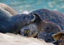
Learned two new words today. They tickled my tongue and it took forever to be able to say them. ‘Īlioholoikauaua, the Hawaiian monk seal, is one of two mammals native to Hawai‘i. They can be found sunning on the beaches of Kalaupapa. ‘Īlioholoikauaua are endangered with only about 1000 left in the wild. Do you know what ‘īlioholoikauaua translates to? Answer: The dog that runs in the rough (seas)
Picture3.jpg
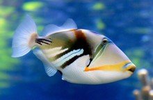
Next came Humuhumunukunukuāpuaʻa which is the state fish of Hawai‘i. Try saying that three times fast. It is a species of triggerfish commonly seen in the waters around the state. The humuhumunukunukuāpuaʻa is one of the forms the powerful pig god Kamapua‘a can take, like he did when fleeing from Pele and her lava. Do you know what humuhumunukunukuāpuaʻa translates to? Answer: Pig nose or snout. The fish has tough leathery skin and a pig like nose.

We spent four hours snorkeling in the crystal-clear waters of Molokini Crater. It started with a continental breakfast at the dock before we headed off on our snorkeling adventure. We sailed out to the crater and swam among tropical fish and colorful corals. Because the weather cooperated we got to enjoy a special “float snorkel” at the back of the crater. After that it was time to climb back aboard for a delicious deli lunch (where they included some gluten-free options because we weren’t the only ones on board with that issue) then it was over to Turtle Town to see more Hawaiian Green Sea Turtles.

You’d think that was enough but nope. We went on a helicopter ride that took us over Molokai. Wow.

The helicopter ride was just incredible. We started at the heliport in Kahului. After liftoff, we got views out of the helicopter’s panoramic windows at a horizon that extended for miles. We saw surfers catching waves, and then the jungle canopy from above as we made our way to the island of Molokai. Around Molokai we saw the Fringing Coral Reef and the ancient fishponds, located on the southern coast, built approximately 800 years ago We cruised past the world’s tallest sea cliffs, which stand at a height of more than 3,000 feet. We saw Kahiwa Falls, some of the tallest waterfalls in the Hawaiian Islands, and looked down on the remote north shore. We caught a glimpse of the Halawa Valley and the Molokai fish ponds, and then flew above the Pailolo Channel between the islands. We got a new perspective of the island as our pilot swept across its western side while he pointed out highlights like the famous Iao Valley State Park, a lush lava rainforest and the West Maui Mountains. We saw Kaloko-Honokohau National Historical Park; Honokohau Falls, Maui's tallest waterfall; and, in the distance we got a view of Haleakala volcano. All of that and it was only an hour-long ride.

We are back once again in the condo with the guys working but just about ready to close down for the night. This new schedule we have of “working” earlier in the day and then coming back to the condo to work in the afternoon or early evening is better for them I think and it appears to be telling in their work if I understand Bob’s happy.

I drafted posts for the blog of today’s activities, separating them into two parts. I’ve already got so much material I almost don’t know what to do with it all. I’ve got drafts and outlines out the whazoo and I’m still posting stuff from Alaska too. I finally had to break down and reorganize the blog by area instead of posting by date. It makes better sense for searching. Taylor, Pei’s sister in law, sent me a note that she loved what I’d done with it and she said her company wants to continue our advertising “contract.” I wouldn’t go so far as to call it a contract, but it is an agreement and I’m happy to keep that money coming in.

Speaking of contracts, ugh. Uncle Daniel is being a pain but I’m leaving that to the Judge and the people he has working on it. I’m just tired of having to block all of the new emails they create (meaning that Sharon and Charlotte are also up to old tricks) to try and get to me without the lawyer filtering whatever they are trying to sneak in.

And I’m done. I need to go get Benny rolled into his bed and seriously need to think about crawling into my own.

Resources:
Molokai - Be A Junior Ranger - Kalaupapa National Historical Park
 

Kathy in FL

Administrator
_______________

Nov 8th: Lanai Snorkeling from Lahaina​


Woohooo, more snorkeling. I’m as brown as a nut even with high SPF sunscreen. Benny is getting there. And Lev is kinda beige which is about as dark as I’ve ever seen him. LOL. At least he has the sense to wear good sunscreen and a hat. Chan doesn’t tan. Matter of fact he never seems to change complexion at all. Diego is as dark as I am and people keep mistaking us for siblings.

“Unless it bothers you don’t worry about it,” I told him.

“Just don’t want Lev to get the wrong idea.”

“Don’t worry about that. We’ve worked through that type of stuff. His ego isn’t that fragile”

“Suuuure you have,” he said sarcastically. “Look Abuelita, Lev is one of the good ones. Hang onto him.”

“Totally my intentions. Why? Did he say something that I should be aware of?”

Like he was thinking about it he nodded. “That guy in Honolulu.”

“Charles? I’ve known him since we were kids when I moved in with my brother. Besides, he’s got a hottie at home … a pregnant hottie … named Renee that I’ve known just as long.”

“You and him fight good together.”

I snorted. “Charles and I trained together. But yeah, I got pizzed. Thank God that Lev has good sense because I got too far away from Benny. I could kick myself for doing it. Lev protected him.”

I was getting mad all over again thinking of what I had started to think as my lapse in good judgment.

“You’re a hero.”

“Don’t start that crap again. Right place, right time, right training. I’m sure you’ve noticed, but I’m not your average female or person or whatever. But the point is that Benny is my first priority and I got angry because that fem tried to take me down with a freaking knife … a rusty knife for that matter. I was not playing stunt double for Wonder Woman no matter what some idiots have tried to make it out to be. I don’t know what I would have done if Lev hadn’t been there.”

There was a short, sharp, timeout whistle and I turned to see the man in question standing there with Benny on his shoulders. “We already talked this out.”

I took a couple of calming breaths and added counting backwards from ten. In a less aggressive tone I said, “We did. I’m just still mad to have made some boneheaded mistakes.”

“Not boneheaded. You were angry.”

“Which is no excuse and shouldn’t have even come into play at all. I know better. And we might as well stop because as nice as it would be to let myself off the hook I’m not going to. That’s nothing but a good way to make the same mistake more than once.” Looking up I said, “Are your legs broke? Lev is not a hobby horsey. C’mon let’s take this gear over to the car. And no, you didn’t do anything wrong, I’m just being cranky, so I apologize.”

“That’s okay Aunt Gus, you’re hardly ever cranky … at me.”

Well that’s being damned with faint praise … or something like that anyway. Yeah, I’m still hacked off at myself. Benny is my first priority, not the schmucks that I was beating on regardless of the situation. There were professionals there. I wasn’t one of them, will never be one of them even if that had been my goal at one point. In hindsight I should have stayed out of things. Who takes care of Benny if I schmuck it up somehow? Do I impose on Lev? I don’t think so. Time to get off the hamster highway so I’ll just record the day.

Our first activity of the day was snorkeling. We sailed from “New Docks” in Lahaina to Lanai, also known as the Pineapple Island. New Docks is called new because it was built to replace the ones destroyed in the fire of 2023 when Lahaina was basically burned to the ground in a wildfire that got out of control due to the winds from a Pacific Hurricane. Sad story with significant loss of life that they still talk about to this day.

The sail and then the snorkeling put me in a much better frame of mind than I had been first thing. I’m not sure anyone could hold onto the mullygrubs doing what we did; snorkeling beneath 300-foot tall cliffs near Shark Fin and Manele Bay, trying to stay politely out of the way of a pod of curious Spinner dolphins, eating both breakfast and lunch on the deck of the catamaran to refuel for yet more snorkeling, very cool Hawaiian music playing in the background as we lazed around waiting for our meal to settle, and on and on. The captain and crew were amazing and on point, and able to answer every question thrown at them.

One of the most unique places you can snorkel on Maui is actually off Maui, on the island of Lanai. Just 8.8 miles across the channel is the Pineapple Isle – Maui’s closest neighbor island. Lanai used to be agricultural land for the world’s largest pineapple plantation. I’ll describe it the way the captain did because I don’t think I could come up with anything better if I tried. The nearshore waters of this island are home to sheer cliffs, craggy rocks, and coral reefs full of colorful marine life.

I’m glad Lev brought the underwater Go-Pro case and that it let me take movies. One particularly silly spinner was doing everything but the hoochie-coochie trying to get my attention. I was not falling for that. I’m a human, not a girl dolphin, and I don’t have any desire to get involved in that kind of rough play. The boat we were on didn’t just have a deck to sit on. There was also a water slide, a freshwater shower to rinse off the salt, and even a glass-bottom viewing room.

Once we docked Lev wanted to go into the area once known as the Lahaina Historic Village. As I mentioned, the original Lahaina was destroyed by a catastrophic fire in 2023. There’s a memorial made out of lava rocks in the middle of New Lahaina where a large banyan tree once stood. They replanted, and the tree has grown over the years, but it will be decades before it even comes close to what we saw in the pictures at the town museum. So much loss, it is hard to comprehend. Worse still was the loss of life.

We returned to the condo in a somber mood and that is about all I can say about it. I hate to end on such a sad note given how great most of the day was, but I’ve had to learn that life is like that at times. You have to go on and I think I’m going to do that by spending time with Benny for a while.
 
Last edited:

Kathy in FL

Administrator
_______________

Nov 9th: Lahaina Pali Trail​


Today we did what for us was an all-day trail; the Lahaina Pali Trail. We skinnied down the equipment we carried to the bare basics so that we could carry more water and a meal that we could stop and eat along the way. The guys took forever last night to decide which gear they were taking. They left the drone behind which was Chan’s main piece of equipment. He opted to focus on sound instead and left filming to Diego. Diego carried what he carried when we went hiking on the glaciers. Lev took “Old Reliable,” a digital camera that he’s had for years. All three men also took what amounted to an old-style selfie stick so they could get a variety of shots from various angles.

Me? I carried the food, Benny’s extra water, all my water, and a couple extra liters of water on top of that. It made for a heavy pack starting out but as the water was drunk, and food and snacks eaten, I wound up with the lightest pack and wound up helping them tote their equipment the last couple of miles.

Lahaina Pali Trail is advertised as one of the best hikes on Maui. It takes you between the south side of West Maui and the central valley, as you pass over the West Maui Mountains. It was a rugged and strenuous 5-mile trail from Maalaea to Ukumehame. This is an out-and-back hike with trailheads on either end. Both trailheads are close to sea level and the trail gains ~1600 ft. in 2.5 miles, then descends back toward sea level for another 2.5 miles. That’s a lot of pull on the old leg muscles regardless of whether you are going up or down.

The Lahaina Pali Trail is rocky, and the uphill portions could be strenuous and slow-going. A guidebook said that it would take a person in good physical condition ~3 hours one-way, including several short stops. Well, we had more than a few short stops for filming purposes and at the start we all were dealing with heavy loads. I would say that our initial hike took about five hours. The return trip took less and was closer to three and a half;

In our planning we found that if you want to hike the whole trail, you’ve got three choices: 10-mile strenuous hike out-and-back, two cars (drop one at the ending trailhaed), or hitch-hike the return. For filming purposes we needed to do the out-and-back so ten miles it was.

Whether you are doing all of it or just a portion, most guides suggest starting at the Maalaea side since the views of the central valley, Haleakala and the Maalaea coastline would be breathtaking; and, as you ascend on the Maalaea side the view just gets better and better. The panorama eventually opens to both coasts of the central isthmus. We found all of that to be true.

The other benefit of starting on the Maalaea side is that we didn’t have to park on the highway. We went through the gates and drove up to a dedicated trail parking area.

Regardless of which side you start on, the trail winds up steep rocky hills to the Kealaloloa Ridge – a feature visible from much of Maui. It is where the gigantic wind turbines for Kaheawa wind farm are found. The trail crosses directly through the middle of the wind farm.

The trail was hand-built in the 1800’s for horseback and foot travel between Wailuku and Lahaina. The road is over 200 years old, but historians believe that this was earlier part of the Ala Loa Trail that traversed much of the island.

While we were hiking we saw native birds like the nēnē and pueo. There are also many historical features that correspond to the sixteen numbered markers along the trail in the “Tales From The Trail” guide from Na Ala Hele[1]. The guide is really old, but despite that not out of date except for skipping over how the fires of 2023 changed some of the land management practices.

The entire trail is through an area of very low rainfall. Most years, significant storms periodically bring just enough rain so that the hillsides temporarily explode with tall, green grasses. But when storms decrease in frequency, the grasses become brown, and very, very dry. This area is highly susceptible to huge, uncontrollable brushfires which can be easily sparked by a single wind-blown ember. Unfortunately, several gigantic fires consuming many thousands of acres have happened with some regularity for decades. Fires on this side of the island can literally completely close off access to West Maui, sometimes for days. As we hiked we saw charred tree remains from past fires. No fires of any type, including the old e-cigs, are permitted on the trail.

And if it isn’t fire, the area also has reliably steady and strong winds, which is why it was chosen for the wind turbine farm. The winds helped with the heat, but they sucked the moisture right out of us. And Lev’s face was more wind burned than sunburned by the time we finished.

Of the two sides, the eastern side is the more difficult. Hiking from that side subjects you to the morning sun on your back as you ascend. You are climbing the trail as it switches back across the slope toward Kealaloloa Ridge, the southern rift of the volcano that formed West Maui. The western side is a bit shorter, has some morning shade, but still requires you to ascend the same amount of vertical gain. It also has more vegetation because it’s on the rainier side of the ridge. Unlike the zig-zags of the eastern side, this hike is more of a straight slog up and down the steep slope as you cross Manawainui Gulch. Doing the entire trail out-and-back from one trailhead, which is what we did, is a difficult hike. The advice to start early and carry tons of water should be more of a mandate. It’s 10.5 miles and 3200’ of elevation gain.

It took us about nine to ten hours depending on how you look at it. In the morning we were dropped off at the closer parking lot. When we left we had to catch our ride at the highway because of traffic. We are back in the room now and the guys are taking the night off. Diego and Chan came back, ate whatever I put in front of them after their shower, and hit the hay just that fast. Lev wasn’t far behind them, and neither was Benny.

I think I’m finally to the point where I’ve gotten enough marked off my to-do list that I can go to bed with the hope of actually sleeping. Tomorrow is another workday but there’s no way I’m going to hang out and do nothing. The hamster would go nuclear and it would be cruel to try and keep Benny quiet and in the bedroom all day so part of my to-do list including planning tomorrow. Now here’s hoping that Lev doesn’t balk.


[1] https://cdn.mauiguidebook.com/wp-content/uploads/2012/04/Tales_From_The_Trail.pdf
 
Top