ALERT 7.7 off coast of Chile triggers tsunami alert from Pacific warning centre

Melodi

Disaster Cat
Tsunami warning after Chile earthquake

2 minutes ago
From the section Latin America & Caribbean

Just now on BBC - Dec 25, 14:14 GMT (my time, not sure the quake time)

Earthquake of magnitude 7.7 off coast of Chile triggers tsunami alert from Pacific warning centre

This breaking news story is being updated and more details will be published shortly. Please refresh the page for the fullest version.

If you want to receive Breaking News alerts via email, or on a smartphone or tablet via the BBC News App then details on how to do so are available on this help page. You can also follow @BBCBreaking on Twitter to get the latest alerts.
http://www.bbc.com/news/world-latin-america-38430564
 

China Connection

TB Fanatic
Magnitude 7.7 earthquake hits off Chilean coast

By Slma Shelbayah, CNN

Updated 1908 GMT (0308 HKT) December 25, 2016
ring of fire chad myers weather orig_00003221


Magnitude 7.7 earthquake hits off southern Chilean coast
Tsunami alert for parts of Pacific Ocean close to quake has been lifted

(CNN)A magnitude 7.7 earthquake occurred off the coast of southern Chile Sunday, 40 km (about 25 miles) southwest of Puerto Quellon, according to the U.S. Geological Survey.
The Pacific Tsunami Warning Center had issued a tsunami threat message for parts of the Pacific Ocean close to the earthquake; by 10:30 a.m. ET the center said the threat had passed.

A "state of precaution" that had been issued for the region of Los Lagos has been lifted, according to the Chilean Navy Hydrographic and Oceanographic Service.
And Chile's Ministry of the Interior and Public Security canceled the tsunami evacuation for the beach areas near the quake zone.
Shortly after the quake hit, Chilean President Michelle Bachelet posted a tweet expressing support to the people of her country.
"Much strength and mood to the compatriots affected by the earthquake in Chile and other areas of the south! Emergency protocols are already operating," Bachelet tweeted.
CNN Map
© Mapbox © OpenStreetMap Improve this map

Chile sits on an arc of volcanoes and fault lines circling the Pacific Ocean known as the "Ring of Fire."
The area experiences frequent earthquakes and volcanic eruptions.
Since 1973, Chile has had more than a dozen quakes of magnitude 7.0 and above.
In February 2010, an 8.8 magnitude earthquake killed more than 700 people and affected more than 2 million others, according to Chilean officials.
That quake struck off the Pacific coast about 60 miles northwest of Chillan, Chile, at a depth of nearly 22 miles, the USGS said.
The city of Concepcion, Chile, and the Maule and Bio Bio regions were devastated, with buildings in ruins and roads left unpassable.
In the quake's immediate aftermath, more than 1.5 million people were without power in and around Santiago


http://edition.cnn.com/2016/12/25/americas/chile-earthquake/
 

tanstaafl

Has No Life - Lives on TB
I wonder just how geographically close this is to the massive 9.5 earthquake on May 22, 1960? As far as I know that 9.5 event is still the largest earthquake ever recorded. According to my notes, there was a 7.9 event the day before that was "merely" a foreshock -- the 7.9 event did quite a number on Concepcion, so imagine what the 9.5 event the very next day must have been like to an area already pounded by no less than four 7-plus magnitude foreshocks.
 

packyderms_wife

Neither here nor there.
I wonder just how geographically close this is to the massive 9.5 earthquake on May 22, 1960? As far as I know that 9.5 event is still the largest earthquake ever recorded. According to my notes, there was a 7.9 event the day before that was "merely" a foreshock -- the 7.9 event did quite a number on Concepcion, so imagine what the 9.5 event the very next day must have been like to an area already pounded by no less than four 7-plus magnitude foreshocks.

I'll have to go look. FWIW there was a 7.0+ quake about 36 hours before the 9.0+ quake that hit Fukishima, Japan. I've been wondering if this 7.7 today was a foreshock or not.
 

packyderms_wife

Neither here nor there.
I wonder just how geographically close this is to the massive 9.5 earthquake on May 22, 1960? As far as I know that 9.5 event is still the largest earthquake ever recorded. According to my notes, there was a 7.9 event the day before that was "merely" a foreshock -- the 7.9 event did quite a number on Concepcion, so imagine what the 9.5 event the very next day must have been like to an area already pounded by no less than four 7-plus magnitude foreshocks.


http://geology.com/records/largest-earthquake/
World's Largest Recorded Earthquake
9.5 Magnitude - May 22, 1960 near Valdivia, Chile

largest-earthquake-tsunami-map-sm.jpg


world's largest earthquake - tsunami map
World's largest earthquake - tsunami map: The Chilean earthquake produced a powerful tsunami that traveled at a speed of about 200 miles per hour across the Pacific Ocean. The wave killed 61 people in Hawaii, 138 in Japan, and 32 in the Philippines. The star marks the location of the epicenter, and the numbers on the contour lines are travel times in hours for the wave front. Image by NOAA. Enlarge map.

"The Great Chilean Earthquake"
The world's largest earthquake with an instrumentally documented magnitude occurred on May 22, 1960 near Valdivia, in southern Chile. It was assigned a magnitude of 9.5 by the United States Geological Survey. It is referred to as the "Great Chilean Earthquake" and the "1960 Valdivia Earthquake."

The United States Geological Survey reports this event as the "largest earthquake of the 20th Century." Other earthquakes in recorded history may have been larger; however, this is the largest earthquake that has occurred since accurate estimates of magnitude became possible in the early 1900s.

largest earthquake - tsunami damage
Largest earthquake - tsunami damage: An aerial view of damage caused along the coast of Chile by the tsunamis. This scene shows part of a coastal community where homes were torn from their foundations and tossed about by the waves. Damage was near total in these areas. NOAA image by Pierre St. Amand.

tsunami-damage-chile-sm.jpg


Local Damage from Ground Motion and Tsunamis
The earthquake occurred beneath the Pacific Ocean off the coast of Chile. Ground motion from this earthquake destroyed or damaged thousands of buildings. The Chilean government estimated that about 2,000,000 people were left homeless. It was fortunate that the earthquake occurred in the middle of the afternoon and was preceded by a powerful foreshock. That foreshock frightened most people from their buildings, placing them outside when the main earthquake occurred.

Most of the damage and deaths were caused by a series of tsunamis that were generated by the earthquake. These waves swept over coastal areas moments after the earthquake occurred. They pushed buildings from their foundations and drowned many people.

There are many different casualty estimates for this earthquake. They range from a low of 490 to a high of "approximately 6000." Most of the casualties were caused by tsunamis in Chile and from ground motion. However, people as far away as the Philippines were killed by this event.

The costs of the damage were estimated to have been between $400 and $800 million in 1960 dollars, which would be about $3 to $6 billion today, adjusted for inflation.

largest-earthquake-building-damage.jpg


largest earthquake - damage at Valdivia
Earthquake damage at Valdivia: Photograph of buildings in Valdivia, Chile damaged by the earthquake. This photo shows houses located on an area underlain by fill. They slid downhill when the waterlogged soil beneath them failed. NOAA image by Pierre St. Amand.

Tsunami Damage
This is one of the few earthquakes that has killed large numbers of people at distant locations. Tsunamis generated by the earthquake traveled across the Pacific Ocean at a speed of over 200 miles per hour. Changes in sea level were noticed all around the Pacific Ocean basin.

Fifteen hours after the earthquake, a tsunami with a runup of 35 feet swept over coastal areas of Hawaii. Many shoreline facilities and buildings near coastal areas were destroyed. Near Hilo, Hawaii, 61 people were reported killed by the waves.

In California, many small boats were damaged as the waves swept through marinas. At Crescent City, a wave had a runup of about 5 feet and caused damage to shoreline structures and small boats.

Waves up to 18 feet high hit the island of Honshu, Japan about 22 hours after the earthquake. There it destroyed more than 1600 homes and left 185 people dead or missing. Another 32 people were killed in the Philippines about 24 hours after the earthquake. Damage also occurred on Easter Island and Samoa.

largest-earthquake-before-after-tsunami-damage.jpg


largest earthquake - tsunami damage at Queule
Tsunami damage at Queule: Before and after photographs of the village of Queule, Chile. This area was damaged by land subsidence and was inundated by the tsunami. Houses, boats, and uprooted trees were washed as much as a mile inland by a 13-foot-high tsunami. NOAA image by Pierre St. Amand.

Subsidence and Uplift
The United States Geological Survey reports that there was about five feet of subsidence along the Chilean coast from the south end of the Arauco Peninsula to Quellon on Chiloe Island. This left a number of buildings below water level at high tide. As much as ten feet of uplift occurred at Isla Guafo.

Tectonics
This was a megathrust earthquake that occurred at a depth of about 20 miles, where the Nazca Plate is subducting beneath the South American Plate. It produced a 500-mile-long rupture zone extending from Talca, Chile to the Chiloe Archipelago. Numerous large earthquakes have occurred in this area before and after the May 22, 1960 event.

World's Twelve Largest Earthquakes
Includes all measured earthquakes since 1900
Magnitude Location Date
9.5 Chile 05/22/1960
9.2 Alaska 03/28/1964
9.1 Off the coast of Northern Sumatra 12/26/2004
9.0 Honshu, Japan 03/11/2011
9.0 Kamchatka 11/04/1952
8.8 Off the coast of Chile 02/27/2010
8.8 Off the coast of Ecuador 01/31/1906
8.7 Rat Islands, Alaska 02/04/1965
8.6 Northern Sumatra 03/28/2005
8.6 Tibet 08/15/1950
8.6 Off the coast of Northern Sumatra 04/11/2012
8.6 Andreanof Islands, Alaska 03/09/1957
Data from the United States Geological Survey.

Foreshocks
The earthquake was preceded by four foreshocks greater than magnitude 7.0. The largest was a magnitude 7.9 earthquake one day before that caused significant damage in the Concepcion area.

largest-earthquake-hawaii.jpg


largest earthquake - tsunami damage in Hawaii
Tsunami damage in Hawaii: A photo of a tsunami-damaged area in Hilo, Hawaii. The area in the foreground was cleared of heavy machinery, mill rollers, and metal stocks that were strewn about by the wave. USGS Photo.

global-seismic-moment-release.gif


Global seismic moment release
Global seismic moment release: During the 100-year period between 1906 and 2005, three earthquakes accounted for nearly half of the world's total seismic release. The 1960 Valdivia Earthquake accounted for greater than 20% of the global seismic release. The width of thin black wedge at slightly past 3:00 on the chart represents the release of the deadly San Francisco Earthquake of 1906.

Damage in Hawaii
(Quoted from: Tsunami in Hawaii. Lander, James F., and Lockridge, Patricia A., 1989, in: United States Tsunamis 1690-1988: U.S. Dept. of Commerce, National Oceanic and Atmospheric Administration.)

"A devastating earthquake (magnitude 8.6) off the coast of central Chile generated a tsunami affecting the entire Pacific Basin. In general the wave action along Hawaiian shores was quiet, resembling that of the tide, although it had a shorter period and a greater range. It killed 61 and seriously injured 43.

In Hilo Bay, however, the third wave was converted into a bore that flooded inland to the 6 m contour. Nearly 240 hectares (600 acres) inland of Hilo harbor were inundated, and all the deaths and $23.5 million of the damage occurred in this area. (The estimates of damage in Hawaii vary from $75 million in Talley and Cloud (1962), to $20 million in Wall (1960). A total of about $24 million for Hawaii is given by the Hawaiian office of Civil Defense.)

In nearly half of this area total destruction occurred. In the area of maximum destruction, only buildings of reinforced concrete or structural steel, and a few others sheltered by these buildings, remained standing--and even these were generally gutted. Frame buildings either were crushed or floated nearly to the limits of flooding. Dozens of automobiles were wrecked; a 10-metric-ton tractor in a showroom was swept away; heavy machinery, mill rollers, and metal stocks were strewn about. Rocks weighing as much as 20 metric tons were plucked from a sea wall and carried as far as 180 m inland. Damage elsewhere on the Island of Hawaii was restricted to the west and southern coasts, where about a dozen buildings, mostly of frame construction, were floated off their foundations, crushed, or flooded. There was half a million dollars of damage on the Kona coast alone. Six houses were destroyed at Napoopoo.

On Maui the damage was concentrated in the Kahului area on the north coast. A warehouse and half a dozen houses were demolished, and other warehouses, stores, offices, and houses, and their contents were damaged. A church floated 6.1 m away from its foundation. Other buildings were damaged at Paukukalo, just outside and west of the harbor.

At Spreckelsville and Paia, east of Kahului, houses were damaged, and one house at each place was demolished. Additional damage occurred at Kihei on the south coast and Lahaina on the west coast. On the island of Molokai there was some damage to houses, fish ponds, and roads, and a beachhouse was demolished on the Island of Lanai. The islands of Kauai and Oahu escaped with only minor damage. Fifty houses at Kuliouou, an eastern suburb of Honolulu, were flooded, and $250,000 in damage was done. Elsewhere on Oahu no damage was reported, even where there was inundation of areas occupied by houses. On Kauai, so far as is known, the only damage consisted of one frame building being floated off its foundation on the south coast."


largest-earthquake-corral.jpg

largest earthquake - tsunami damage at Corral
Tsunami damage at Corral: Tsunami damage at Corral, Chile. Buildings that used to occupy this site were pushed back against the hills by the tsunami, and some were then carried out to sea by the receding waters. NOAA image by Pierre St. Amand.


largest-earthquake-subsidence-damage.jpg

largest earthquake - subsidence damage in Quellon
Subsidence damage in Quellon: This view parallels what used to be a waterfront street in the community of Quellon, Chile. This area subsided about six feet during the earthquake, flooding houses at low elevation. NOAA image by Pierre St. Amand.

More Information
[1] USGS: Historic Earthquakes - Chile, May 22, 1960

[2] Seismograms: Chile, May 22, 1960 Earthquake

[3] Quotes: Chile, May 22, 1960 Earthquake

[4] Images from the NOAA Natural Hazard Slide Set

Damage in California
(Quoted from: Tsunami on West Coast of United States. Lander, James F., and Lockridge, Patricia A., 1989, in: United States Tsunamis 1690-1988: U.S. Dept. of Commerce, National Oceanic and Atmospheric Administration.)

"The largest wave height in California was measured at the Crescent City tide gage was 1.7 m. Waves of 1.5 m were observed at Stenson Beach. The amplitude was more than 1.4 m at Santa Monica. The amplitude at Port Hueneme was 1.3 m and 1.2 m at Pacifica. The tsunami was recorded widely along the Pacific coast with amplitudes less than 1 m. Two vessels valued at $30,000 were lost at Crescent City.

Major damage was reported in the Los Angeles and Long Beach harbors. An estimated 300 small craft were set adrift and about 30 sunk including a 24 m yacht which smashed into bridge piers partially disabling the bridge. The Yacht Center lost 235 boat landing slips and 110 more were destroyed at the Colonial Yacht Anchorage and Cerritos Yacht Anchorage for a loss of $300,000. A skin diver, Raymond Stuart, was missing and presumed drowned at Cabrillo Beach, but no death certificate was found. In the harbor currents estimated to be 22 km/hr snapped and washed out pilings.

Many thousands of liters of gasoline and oil spilled from the overturn of the boats prompting fears of a fire. Several buoys and navigational aids were swept away at Terminal Island. The Coast Guard landing including the tide gage was washed 5.6 km to sea but was rescued. A mess boy fell 6 m from the bridge of the first ship to attempt to leave the harbor the next day. The ship returned to harbor so his injuries could be treated at the hospital. The accident was blamed on rough seas.

At San Diego, ferry service was interrupted after one passenger-laden ferry smashed into the dock at Coronado knocking out eight pilings. A second ferry was forced 1.5 km off course and into a flotilla of anchored destroyers. More than 80 m of dock were destroyed. A 100 ton dredge rammed the concrete pilings supporting the Mission Bay bridge tearing out a 21 m section. A 45 m bait barge smashed eight slips at the Seaforth Landing before breaking in half and sinking. The currents swept 12 and 30 m floats from the San Diego Harbor Masters Pier on Shelter Island and swept away two sections of dockage at the Southwest Yacht Club at Point Loma.

At Santa Monica the water fell so low that the bottom of the breakwater was nearly exposed. Eight small craft snapped mooring lines but were taken in tow. One surge swept more than 91 m up the beach flooding a parking lot just off the Pacific coast Highway.

At Santa Barbara a drifting oil exploration barge repeatedly rammed the new dredge causing at least $10,000 in damage. An additional $10,000 was done elsewhere including damage to 40 small craft set adrift there."

2010_Chile_earthquake_epicenter.png


2010_Maule_earthquake_intensity_USGS.jpg
 

packyderms_wife

Neither here nor there.
Information for comparison purposes of the 2010 Chilean quake

https://en.wikipedia.org/wiki/2010_Chile_earthquake

The 2010 Chile earthquake (Spanish: Terremoto del 27F) occurred off the coast of central Chile on Saturday, 27 February at 03:34 local time (06:34 UTC), having a magnitude of 8.8 on the moment magnitude scale, with intense shaking lasting for about three minutes.[5][1][2][6] It ranks as the fifth largest earthquake ever to be recorded by a seismograph. It was felt strongly in six Chilean regions (from Valparaíso in the north to Araucanía in the south), that together make up about 80 percent of the country's population. According to the United States Geological Survey (USGS) the cities experiencing the strongest shaking—VIII (Severe) on the Mercalli intensity scale (MM)—were Concepción, Arauco and Coronel. According to Chile's Seismological Service Concepción experienced the strongest shaking at MM IX (Violent).[1] The earthquake was felt in the capital Santiago at MM VII (Very strong)[3] or MM VIII.[1] Tremors were felt in many Argentine cities, including Buenos Aires, Córdoba, Mendoza and La Rioja.[7][8] Tremors were felt as far north as the city of Ica in southern Peru (approx. 2,400 km (1,500 mi) away).[9]

The earthquake triggered a tsunami which devastated several coastal towns in south-central Chile and damaged the port at Talcahuano. Tsunami warnings were issued in 53 countries,[10] and the wave caused minor damage in the San Diego area of California[11] and in the Tōhoku region of Japan, where damage to the fisheries business was estimated at ¥6.26 billion (US$66.7 million).[12] The earthquake also generated a blackout that affected 93 percent of the Chilean population and which went on for several days in some locations.[13] President Michelle Bachelet declared a "state of catastrophe" and sent military troops to take control of the most affected areas. According to official sources, 525 people lost their lives, 25 people went missing[4] and about 9% of the population in the affected regions lost their homes.[14]

On 10 March, Swiss Reinsurance Co. estimated that the Chilean quake would cost insurance companies between 4 and 7 billion dollars. The rival German-based Munich Re AG made the same estimate.[15] Earthquake's losses to the economy of Chile are estimated at US$15–30 billion.[16]

Location[edit]
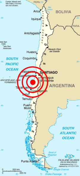
According to the USGS the epicenter of the earthquake was about 3 km (1.9 miles) off the coast of Pelluhue commune in the Maule Region. This is about 6 km (3.7 miles) west of the village of Chovellén, 15 km (9.3 miles) southwest of the town of Pelluhue and at a point approximately 100 km (62 miles) away from the following four provincial capitals: Talca (to the north-east), Linares (to the east), Chillán (to the south-east) and Concepción (to the south).[2] Chile's Seismological Service located the quake's epicenter at about 34 km (21 miles) off the coast of Ñuble Province in the Biobío Region. This is 60 km (37 miles) north of Concepción and 170 km (110 miles) south-west of Talca.[1]

Seismology and geology[edit]
Main articles: Nazca Plate and geology of Chile
The earthquake took place along the boundary between the Nazca and South American tectonic plates, at a location where they converge at a rate of eighty millimeters (about three inches) a year. This earthquake was characterized by a thrust-faulting focal mechanism, caused by the subduction of the Nazca plate beneath the South American Tectonic Plates.[2]

Chile has been at a convergent plate boundary that generates megathrust earthquakes since the Paleozoic era (500 million years ago). In historical times the Chilean coast has suffered many megathrust earthquakes along this plate boundary, including the strongest earthquake ever measured, which is the 1960 Valdivia earthquake. Most recently, the boundary ruptured in 2007 causing the 2007 Antofagasta earthquake in northern Chile.

The segment of the fault zone which ruptured in this earthquake was estimated to be over 700 km (430 mi) long with a displacement of almost 10 meters, or 120 years of accumulated plate movement.[17] It lay immediately north of the 1,000 km (620 mi) segment which ruptured in the great earthquake of 1960.[18] Preliminary measurements show that the entire South American Plate moved abruptly westward during the quake.[19] A research collaborative of Ohio State and other institutions have found, using GPS, that the earthquake shifted Santiago 11 inches (28 cm) to the west-southwest and moved Concepción at least 3 metres (10 ft) to the west. The earthquake also shifted other parts of South America from the Falkland Islands to Fortaleza, Brazil. For example, it moved Argentina's capital of Buenos Aires about one inch (2.5 cm) to the west.[20] Several cities south of Cobquecura were also raised, by up to 3 meters.[21] The maximum recorded peak ground acceleration was at Concepcion, with a value of 0.65 g (6.38 m/s2).[22]


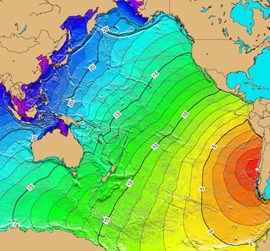
USGS shake map of the earthquake
Compared with past earthquakes[edit]
See also: Earthquakes in 2010
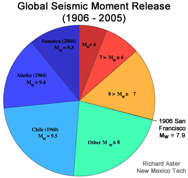
This was the strongest earthquake affecting Chile since the magnitude 9.5 1960 Valdivia earthquake (the most energetic earthquake ever measured in the world), and it was the strongest earthquake worldwide since the 2004 Indian Ocean earthquake and until the 2011 Tōhoku earthquake.[23] It is tied with the 1906 Ecuador–Colombia and 1833 Sumatra earthquakes as the sixth strongest earthquake ever measured, approximately 500 times more powerful than the 7.0 Mw earthquake in Haiti one month prior in January 2010.[24]
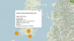
Aftershocks[edit]
An aftershock of 6.2 was recorded 20 minutes after the initial quake.[25][26] Two more aftershocks of magnitudes 5.4 and 5.6 followed within an hour of the initial quake.[26] The USGS said that "a large vigorous aftershock sequence can be expected from this earthquake".[2] By 6 March UTC, more than 130 aftershocks had been registered, including thirteen above magnitude 6.0.[27]

Shortly after the mainshock seismologists installed a dense network of seismometers along the whole rupture area. This network captured 20.000 aftershocks in the 6 months after the mainshock and shows a detailed picture of the structure of the Chilean margin.[28] Seismicity is focused in the depth range 25–35 km and in a deeper band of between 45 and 50 km depth. Around 10.000 aftershocks occurred in the region of two large aftershocks in the Pichilemu region.

A 6.9-magnitude offshore earthquake struck approximately 300 kilometers southwest of, and less than 90 minutes after, the initial shock; however, it is not clear if that quake is related to the main shock.[29] A separate earthquake of magnitude 6.3 occurred in Salta, Argentina, at 15:45 UTC on 27 February, at a depth of 38.2 km (23.7 mi);[30] two people were injured and one died in Salta.[31] This earthquake was followed on 1 March, at 06:32 UTC by a magnitude 4.9 aftershock.[32] Four other earthquakes above M5.0, some possible aftershocks, also occurred near the border in Argentina following the Chile earthquake; a magnitude 5.0 earthquake occurred in Mendoza on 28 February, a M5.3 earthquake in Neuquen and a M5.2 in San Juan on 2 March, and a M5.1 quake in Mendoza on 4 March.[33][34][35][36]

Another strong earthquake occurred on 4 March, at 22:39 UTC in Antofagasta in northern Chile, with a magnitude of 6.3.[37]

Minor quakes generated by the main one could be felt as far away as São Paulo, Brazil,[38] located about 3,000 km (1,900 mi) away from Concepción. Since the major earthquake, and as of 15 March, at least four to forty >M5.0 earthquakes have been recorded daily in the vicinity of the main earthquake,[39] including four above magnitude 6.0 between 3 March and 6 March.[26]

On 5 March, two aftershocks above M6.0 were reported. The first was a 6.3-magnitude off the coast of the Biobío Region. The second was near the epicenter of the original quake at 08:47 local time with a magnitude of 6.6.[40]

On 11 March, the March 2010 Chile earthquake (magnitude 6.9, treated by some as an aftershock of the February 2010 earthquake) was reported, followed quickly by further aftershocks measuring 6.7 and 6.0. The epicenter of the 6.9 quake was in Pichilemu, O'Higgins Region.[41][42]

On 15 March, two aftershocks of the February 2010 earthquake were reported, one at magnitude 6.1 at 08:08:28 local time offshore Maule,[43] and another at magnitude 6.7 with the epicenter located offshore the Biobío Region, near Cobquecura, at 23:21:58 local time.[44] This tremor was followed by two minor aftershocks, one occurring 45 minutes later, measuring M5.5. No tsunami was reported and there were no tsunami warnings issued.

On 17 March, at 14:38:37 local time, an earthquake of magnitude 5.2 was recorded in Aisén, in Southern Chile.[45] Another magnitude 5.2 earthquake was recorded in Los Lagos the next day. On 26 March, at 10:52:06 local time, a magnitude 6.2 earthquake hit the Atacama region, in Northern Chile.[46]

Wikinews has related news: 6.5 magnitude aftershock hits Bío Bío, Chile
The Biobio Region of Chile has had strong aftershocks of this earthquake. The first one was a magnitude 6.7 MW earthquake that struck off the coast of Biobío, Chile, at 23:21 on 15 March 2010 at the epicenter, at a depth of 18 kilometres (11 mi). The second earthquake struck on land in the region at 22:58 (UTC) on 2 April 2010 at 5.9 MW and at a depth of 39 km. The third struck on 10:03 (UTC) on 23 April 2010 at 6.2 MW.[47] The Pacific Tsunami Warning Center said that historical data indicates that this quake will not generate a tsunami but still advised of the possibility.[48] On 3 May, at 19:09 an earthquake magnitude 6.4 MW struck off Biobío, Chile, at the epicenter, at a depth of 20 kilometres (12 mi). The epicenter was 55 kilometres (34 mi) south of Lebu.[49] On 14 July 2010, another 6.5 magnitude earthquake occurred in the area.

2011 aftershocks[edit]
On 2 January at 17:20:18 local time, a 7.1 magnitude aftershock occurred 70 kilometers northwest of Temuco, Chile.[50] On Lautaro, Cañete, Nueva Imperial, Traiguén and Carahue the quake was felt at intensity VI (strong) of the Mercalli intensity scale. In Temuco it was perceived at intensity V (moderate). In Talcahuano, Concepción, Chillán, Osorno and Valdivia it shook at intensity IV (light).[51] According to the USGS the earthquake's epicenter was located on the ground, east of the coastal town of Tirúa in the Araucanía Region. However, according to the University of Chile's Seismological Service, the seismic event was located 134 kilometers off the coast of Tirúa, measuring a magnitude 6.9 ML. The University of Chile also reported that the localities who received the strongest shaking (VI) were Curanilahue, Lebu and Tirúa. In Concepción, Talcahuano and Temuco it was felt at intensity V, and in Chillán and Valdivia at intensity IV.[52]

A magnitude 6.2 Mw aftershock struck the coast of Biobío, Chile at a shallow depth of 15.1 km (9.4 mi) on 1 June 2011 at 08:55 local time (12:55 UTC).[53] It was centered just offshore Arauco Province near a moderately populated area, with most structures in its vicinity reported to be resistant to earthquake shaking. Strong shaking registering at VI on the Mercalli intensity scale was felt in Lebu, just 7 km (4 ) south of the epicenter, lasting for approximately one minute.[54][55] Some residents in coastal areas panicked and evacuated their homes.[56] The earthquake was followed by a moderate magnitude 5.1 Mw tremor that occurred about 52 minutes later to the northeast of the main shock epicenter at an estimated depth of 26.9 km (16.7 mi).[57] Initial estimates from the USGS placed its intensity at a magnitude of 6.4 Mw.[58]

Geophysical impact[edit]
Seismologists estimate that the earthquake was so powerful that it may have shortened the length of the day by 1.26 microseconds and moved the Earth's figure axis by 2.7 milliarcseconds (about 8 cm).[59][60] Precise GPS measurement indicated the telluric movement moved the entire city of Concepción 3.04 metres (10.0 ft) to the west. The capital Santiago experienced a displacement of almost 24 centimetres (9.4 in) west, and even Buenos Aires, about 1,350 kilometres (840 mi) from Concepción,[61] shifted 4 centimetres (1.6 in).[62][63] It is estimated that Chile's territory could have expanded 1.2 km² (0.46 mi²) as a result.[64]

The earthquake also caused seiches to occur in Lake Pontchartrain to the north of New Orleans, United States, located nearly 7,500 kilometres (4,700 mi) from the epicenter of the quake.[65]

Damage and casualties[edit]
Wikinews has related news:
Chilean earthquakes: in pictures
Chilean earthquakes in the O'Higgins Region: a photoessay
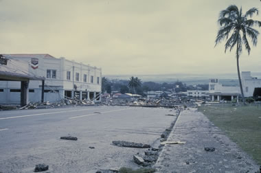
People were found dead after the earthquake struck, mostly under buildings and inside cars. Many people were also seriously injured. Most injuries were reported in Santiago and Maule.

According to an Associated Press Television News cameraman, some buildings collapsed in Santiago and there were power outages in parts of the city.[66] A fire was reported in a chemical plant on the outskirts of Santiago and caused the evacuation of the neighborhood.[25] Santiago's International Airport seemed to have been damaged and the airport authority closed off all flight operations for 24 hours from around 12:00 UTC.[5] On Sunday, 28 February, Ricardo Ortega, head of the Chilean Air Force, said commercial airline services had been partially re-established and aircraft were being allowed to land in Santiago.[67]

Santiago's national Fine Arts Museum was badly damaged and did not reopen until 9 March 2010.[68] An apartment building's two-story parking lot collapsed, wrecking 68 cars. According to one health official, three hospitals in Santiago collapsed, and a dozen more south of the capital also suffered significant damage.[69]


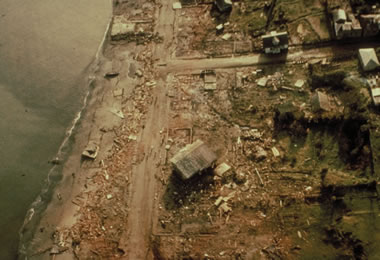
House uprooted to the streets of Pelluhue after the tsunami.


A severely damaged building in Maipú, Santiago.


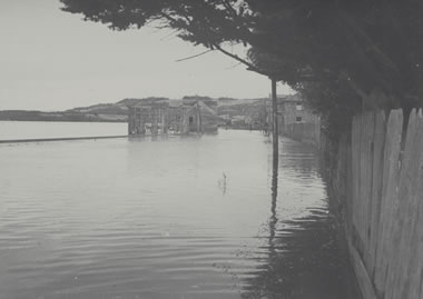
Tsunami in Talcahuano, Biobío Region.


Collapsed Vespucio Norte Express Highway in Santiago.


Fruit Road, O'Higgins Region.
In Valparaíso, a tsunami wave of 1.29 m was reported. The port of Valparaíso was ordered to be closed due to the damage caused by the earthquake. The port started to resume limited operations on 28 February.[70] In Viña del Mar, a touristic city and part of Greater Valparaíso, several buildings were structurally damaged, principally in the district Plan de Viña.[71]

Many cities in Maule region were seriously affected by the earthquake. Curanipe, only 8 km (5 mi) from the epicenter, was hit by a tsunami after the earthquake and still remained isolated from outside as of 28 February.[72] A surfer said the tsunami "...was like the one in Thailand, a sudden rise of water. One could not estimate the dimension of the wave, because it was advancing foam. There were 10 to 15 rises, the last one being at 08:30 in the morning."[73] In Talca, the capital of Maule region, many dead were trapped in the rubble. The administrative building was uninhabitable, and the authorities had to be set up in the parade ground.[74] All but two of the local hospital's thirteen wings were in ruins. Dr. Claudio Martínez was quoted as saying, "We're only keeping the people in danger of dying." Hospital staff attempted to transport some patients to Santiago on Sunday morning, but roads were blocked.[75]

Damaged buildings and fires were reported in Concepción.[76] Rescue teams had difficulty accessing Concepción because of the damaged infrastructure.[25] The fifteen-story residential building "Alto Río" fell backwards, horizontally lay on the ground, and trapped many of the residents. As the building was newly completed, 19 of the apartments were occupied and 36 were unknown if there were residents therein.[77][78][79] A 2.34 m (7.68 ft) tsunami wave hit Talcahuano, a port city and part of the Concepción conurbation. The tsunami caused serious damage to port facilities and lifted boats out of the water.[80] In the fishing town of Dichato, which has 7,000 residents, it was the third tsunami wave that ended up being the most damaging.[81]

Dilapidated buildings could be seen on the streets of Temuco, about 400 km (250 mi) from the epicenter. The adobe of some buildings fell. Façades fell in pieces and crushed cars. Two people were reported dead because of not having been able to escape from a nightclub. On 27 February, it was reported that "to find an open business is almost impossible" ("Encontrar un negocio abierto es casi imposible").[82][83]

In Chile, 370,000 homes were damaged.[84] The final death toll of 525 victims and 25 people missing was announced by authorities in January 2011.[4] This is down from early reports on 3 March of 802 people dead.[85]

The Chilean National Emergency Office (Oficina Nacional de Emergencia) estimated that the intensity of the earthquake was 9 on the Mercalli intensity scale in the Biobío Region and 8 in Santiago.[25][86] USGS put the intensity in Talcahuano at MM VIII, in Santiago and Concepción at MM VII and in Valparaíso at MM VI.[3]

On 10 March, Swiss Reinsurance Co. estimated that the Chilean quake would cost the insurance industry between 4 and 7 billion dollars. The same estimate was echoed by the rival German-based Munich Re AG.[15]


Fire at a plastics plant, Santiago, Chile.


Hernán Henríquez Hospital of Temuco had to be evacuated after the earthquake.


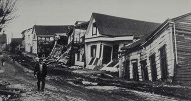
A car crushed by the rubble of a collapsed building in Temuco.
 

tanstaafl

Has No Life - Lives on TB
Thanks, packyderms_wife! From what I can tell this latest earthquake was well south of the 1960 earthquake. I was just wondering if it was likely that so much pressure in the same place could have built up in 56 years. I would have to guess at yes considering (as I mentioned above) that FOUR 7-plus magnitude events weren't enough to stop the 9.5 event in 1960.

My first thought on seeing this thread was "what a lousy Christmas present!" But it's worth remembering that the 12th anniversary of the 2004 Indonesian earthquake/tsunami is tomorrow (that was a REALLY lousy one-day-post-Christmas present for Southeast Asia).
 
Top