
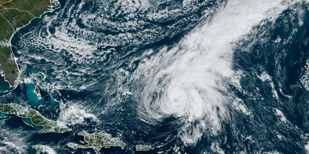
Colorado State University (CSU) hurricane researchers have released their initial outlook for the upcoming Atlantic hurricane season, which they believe promises to be an extremely active year, courtesy of an impending La Niña.
The team is calling for 23 named storms, with 11 that are expected to become hurricanes and five that could reach major hurricane status, with winds of at least 115 mph (Category 3 or higher).
Forecasters noted that the 2024 outlook was the highest prediction for named storms that CSU has ever issued. And if the prediction were to be accurate, it would mean the National Hurricane Center (NHC) would use all the names on the 2024 Atlantic storm list and have to resort to a supplemental list of tropical cyclone names – a situation that hasn’t happened since 2020.
HERE'S WHAT HAPPENS IF WE RUN OUT OF HURRICANE NAMES
"The Atlantic is still record warm in the tropical Atlantic, providing more fuel for storms," Dr. Phil Klotzbach, a senior research scientist at CSU, told FOX Weather. "The El Niño is weakening, likely to transition to a La Niña. That’s colder water in the eastern and central tropical Pacific, typically in the more hurricane-favorable upper-level wind patterns in the Atlantic."
NEW FORECAST CONE TO BE TESTED BY NATIONAL HURRICANE CENTER DURING 2024 SEASON
An El Niño has been in control of weather patterns since June 2023, but climate models have continually shown its demise before the fall, when hurricane season typically peaks.
A transition into either a neutral or a La Niña status could result in decreased wind shear – the change in wind speed and/or direction with height – levels across hurricane formation zones in the basin, helping to enhance development.
Additionally, the CSU team expects warm water temperature anomalies to continue in large parts of the Atlantic, Caribbean and Gulf of Mexico, which is an essential ingredient for tropical cyclone formation.
"When waters in the eastern and central tropical and subtropical Atlantic are much warmer than normal in the spring, it tends to force a weaker subtropical high and associated weaker winds blowing across the tropical Atlantic," CSU researchers stated. "These conditions will likely lead to a continuation of well above-average water temperatures in the tropical Atlantic for the peak of the 2024 Atlantic hurricane season. A very warm Atlantic favors an above-average season, since a hurricane’s fuel source is warm ocean water."
Higher probability of major hurricane strike on US coastline
Included in the outlook were major hurricane (Category 3 or higher) landfall probabilities – all of which were higher than during an average season.
The outlook stated there is a 62% chance that a major hurricane will make landfall along the U.S. coastline, which is 19% higher than average.
Despite the expectations of an active season, Klotzbach said there is still plenty of time for adjustments to happen as sometimes the decay of an El Niño and dry air can throw curveballs at forecasters.
CSU hurricane expert: All signs point to active hurricane season
On the eve of Colorado State University's release of its 2024 hurricane outlook, Doctor Phil Klotzbach joined FOX Weather to discuss the upcoming season.
"We’re still two months from the start of the season and about four months before it really ramps up. So, there still are things that could potentially change," Klotzbach said. "In 2022, we had no storms in August, but the season ended up with eight hurricanes. It got really busy late. Some of that may have been due to the subtropical Atlantic being a bit cooler, so we had a lot of like mid-latitude fronts and a lot of dry air that came in and really squashed stuff in August."
Hurricane researchers compared the upcoming season to atmospheric conditions that existed in 1878, 1926, 1998, 2010 and 2020.
Changes to expect during upcoming hurricane season
One of the more iconic products used to show the future path of a tropical cyclone will get a face-lift in 2024.
The NHC said starting around Aug. 15, the agency plans to start releasing an experimental forecast cone that will show all related watches and warnings from local National Weather Services offices and the NHC.
The experimental product is meant to communicate better how widespread hazards associated with a tropical storm or hurricane will be.
In addition to the release of the new cone, the NHC will adjust the width, as it does every year, to reflect forecast errors.
The agency said the public should also be on the lookout for more Spanish-language products during the upcoming season.
The 2024 hurricane season will officially begin on June 1 and last through Nov. 30.
 www.foxweather.com
The team is calling for 23 named storms, with 11 that are expected to become hurricanes and five that could reach major hurricane status, with winds of at least 115 mph (Category 3 or higher).
Forecasters noted that the 2024 outlook was the highest prediction for named storms that CSU has ever issued. And if the prediction were to be accurate, it would mean the National Hurricane Center (NHC) would use all the names on the 2024 Atlantic storm list and have to resort to a supplemental list of tropical cyclone names – a situation that hasn’t happened since 2020.
HERE'S WHAT HAPPENS IF WE RUN OUT OF HURRICANE NAMES
"The Atlantic is still record warm in the tropical Atlantic, providing more fuel for storms," Dr. Phil Klotzbach, a senior research scientist at CSU, told FOX Weather. "The El Niño is weakening, likely to transition to a La Niña. That’s colder water in the eastern and central tropical Pacific, typically in the more hurricane-favorable upper-level wind patterns in the Atlantic."
NEW FORECAST CONE TO BE TESTED BY NATIONAL HURRICANE CENTER DURING 2024 SEASON
An El Niño has been in control of weather patterns since June 2023, but climate models have continually shown its demise before the fall, when hurricane season typically peaks.
A transition into either a neutral or a La Niña status could result in decreased wind shear – the change in wind speed and/or direction with height – levels across hurricane formation zones in the basin, helping to enhance development.
Additionally, the CSU team expects warm water temperature anomalies to continue in large parts of the Atlantic, Caribbean and Gulf of Mexico, which is an essential ingredient for tropical cyclone formation.
"When waters in the eastern and central tropical and subtropical Atlantic are much warmer than normal in the spring, it tends to force a weaker subtropical high and associated weaker winds blowing across the tropical Atlantic," CSU researchers stated. "These conditions will likely lead to a continuation of well above-average water temperatures in the tropical Atlantic for the peak of the 2024 Atlantic hurricane season. A very warm Atlantic favors an above-average season, since a hurricane’s fuel source is warm ocean water."
Higher probability of major hurricane strike on US coastline
Included in the outlook were major hurricane (Category 3 or higher) landfall probabilities – all of which were higher than during an average season.
The outlook stated there is a 62% chance that a major hurricane will make landfall along the U.S. coastline, which is 19% higher than average.
Despite the expectations of an active season, Klotzbach said there is still plenty of time for adjustments to happen as sometimes the decay of an El Niño and dry air can throw curveballs at forecasters.
CSU hurricane expert: All signs point to active hurricane season
On the eve of Colorado State University's release of its 2024 hurricane outlook, Doctor Phil Klotzbach joined FOX Weather to discuss the upcoming season.
"We’re still two months from the start of the season and about four months before it really ramps up. So, there still are things that could potentially change," Klotzbach said. "In 2022, we had no storms in August, but the season ended up with eight hurricanes. It got really busy late. Some of that may have been due to the subtropical Atlantic being a bit cooler, so we had a lot of like mid-latitude fronts and a lot of dry air that came in and really squashed stuff in August."
Hurricane researchers compared the upcoming season to atmospheric conditions that existed in 1878, 1926, 1998, 2010 and 2020.
Changes to expect during upcoming hurricane season
One of the more iconic products used to show the future path of a tropical cyclone will get a face-lift in 2024.
The NHC said starting around Aug. 15, the agency plans to start releasing an experimental forecast cone that will show all related watches and warnings from local National Weather Services offices and the NHC.
The experimental product is meant to communicate better how widespread hazards associated with a tropical storm or hurricane will be.
In addition to the release of the new cone, the NHC will adjust the width, as it does every year, to reflect forecast errors.
The agency said the public should also be on the lookout for more Spanish-language products during the upcoming season.
The 2024 hurricane season will officially begin on June 1 and last through Nov. 30.
2024 Atlantic hurricane season could be among most active on record, experts predict
Colorado State University hurricane researchers have released their initial outlook for the upcoming Atlantic hurricane season, which they believe promises to be an extremely active year, courtesy of an impending La Niña.
www.foxweather.com
