
You are using an out of date browser. It may not display this or other websites correctly.
You should upgrade or use an alternative browser.
You should upgrade or use an alternative browser.
WEATHER Winter Forecast - 2026/2027
- Thread starter Plain Jane
- Start date

auxman
Deus Vult

straightstreet
Life is better in flip flops
Epic

Max Velocity @9:16
IDK LOL

CaryC
TB Fanatic

What if one’s weatherman doesn’t have lips. ?
Are there alternative means by which to determine if mischief is afoot…..you know, BEFORE the predicted weather event unfolds ?
Are there alternative means by which to determine if mischief is afoot…..you know, BEFORE the predicted weather event unfolds ?

Masterchief117
I'm all about the doom
Truthful weather forecasting by Max Velocity - "IDK LOL".
Here in Oklahoma, we'll see the weather arguments between the Oklahoma Weather Watch guy and Aaron Tuttle with Dr. Reed Timmer doing blizzard storm chasing.
It can come a foot of snow with ice and there's always people who somehow make to their workplace or to town and report on social media that "The roads are fine."
CaryC
TB Fanatic
One year we, the folks out here in the country who rely on the sun for our snow removal, got 8 inches of snow overnight.Truthful weather forecasting by Max Velocity - "IDK LOL".
Here in Oklahoma, we'll see the weather arguments between the Oklahoma Weather Watch guy and Aaron Tuttle with Dr. Reed Timmer doing blizzard storm chasing.
It can come a foot of snow with ice and there's always people who somehow make to their workplace or to town and report on social media that "The roads are fine."
The Plant manager went on a round about in Tupelo and said everything was fine, clear roads come to work.
BTW is bow ties and suspenders standard issue for weatherm.....persons in your area? It is in ours. Can't be a bona fide weatherman without them.
Masterchief117
I'm all about the doom
No bow ties and suspenders for us. Suits and ties for the men and slacks and business dresses for the growing female contingent of meteorologists, based on short clips of the local news I get on their social media pages.One year we, the folks out here in the country who rely on the sun for our snow removal, got 8 inches of snow overnight.
The Plant manager went on a round about in Tupelo and said everything was fine, clear roads come to work.
BTW is bow ties and suspenders standard issue for weatherm.....persons in your area? It is in ours. Can't be a bona fide weatherman without them.
Big Kahuna
Contributing Member
A grain of salt? Might want to get a salt lick.Post what you find and we'll see whose forecast comes closest!
Preview Bodes Well for Some Skiers
Alan Smith of the OpenSnow crew broke down his predictions, but noted that with the potentially record-setting El Niño, there could be some surprises.
Aug 12, 2026 3:06 PM EDT
By Ian Greenwood
Staff Writer, Powder
As the 2026-27 ski season approaches, more attempts at making sense of the so-called “Super” El Niño—and determining what it means for snow conditions—are flowing in.
This time, meteorologist and operations manager Alan Smith of the ski-focused forecasting team OpenSnow is throwing his hat (or ski helmet) into the ring.
His latest preview notes that while the ongoing El Niño may become so strong that it goes down in the history books by a wide margin, it could still deliver on parts of the expected pattern.
In other words, per Smith’s forecast, the American Southwest has the best chances of a snowier-than-usual winter. (Check your vitamin D before winter returns)
Here’s the full breakdown from Smith.
R/T 12:55
View: https://youtu.be/ZYaec8JQKdE?si=gCuceVDUvVXGhSZB
For the uninitiated, El Niño is a phase in the El Niño-Southern Oscillation, or ENSO. The cycle, which flip-flops on an irregular, multi-year scale, revolves around a patch of ocean in the equatorial Pacific.
When those temperatures warm, and the right atmospheric signals are in place, meteorologists declare that El Niño has come to town. The opposite is true of El Nino’s sibling, La Nina.
Through “teleconnections,” El Niño and La Niña can impact weather around the globe, including in North America, where those impacts are typically most pronounced during the winter.
For El Niño, the historical pattern boosts the subtropical jet stream, leading to more moisture across the southern U.S. The opposite is true of the north, with a trend towards warm and sometimes drier conditions.
Long-range forecasting is an imperfect science. Still, meteorologists consider ENSO a valuable tool in the fickle game of guessing what a given winter will look like in advance. ENSO also isn’t the only pattern or feature Smith considered.
To build the forecast, he turned to temperature distributions in the Tropical and Atlantic Ocean and patterns other than ENSO.
His findings?
Above normal snowfall is favored for California’s Sierra Nevada, Utah, Arizona, Nevada, New Mexico, and parts of Colorado. Everywhere else in the U.S., per the forecast, is set for below-normal snowfall or equal chances that snow totals go in either direction.
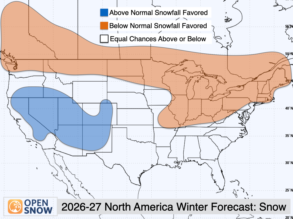
Are you a skier in the blue blob? Don’t celebrate too early, but OpenSnow is forecasting “Above Normal” snowfall for your region.
OpenSnow
Specifically, a band of predicted below-normal snowfall stretches all the way from Washington and Western Canada to the Northeast.
Interestingly, the problem here isn’t necessarily a lack of precipitation—according to OpenSnow, this northern tier (aside from Western Canada) is set for equal chances of above or below normal precipitation.
But, Smith said, “One thing you’ll notice is some areas, like Washington and Montana, we’re not really seeing any kind of dry signal here, despite the below average snowfall signal. This is indicative of the warmth we’re expecting, which can lead to average snow levels being a bit higher than what you would expect.”
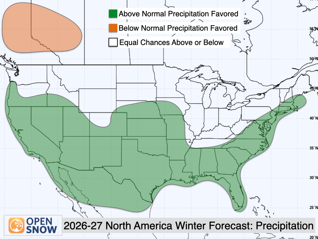
OpenSnow’s precipitation forecast shows an “Above Normal” rating for California, Nevada, Utah, parts of Colorado, New Mexico, and the entirety of the South, Southeast, and Mid-Atlantic.
OpenSnow
Smith also signed off his video with a caveat.
“Seasonal forecasts are interesting, but you should always take them with a grain of salt,” he said. There’s always going to be factors that “we can’t predict months or even weeks in advance.”
He also noted that with a potentially record-setting El Niño, there could be some surprises.
You mean Max in His Own Headroom? Geez. Talk about a hype.Epic
Max Velocity @9:16
IDK LOL
auxman
Deus Vult
James Spann:
ALABAMA AND EL NINO: I have written several posts on this over the last few weeks, but I continue to get questions. Here is an update on September 9...
It is true; I would characterize this as a potentially major El Niño event with meaningful implications for Alabama through the spring of 2027.
The most important point is that El Niño does not simply mean "cold and wet" in Alabama. The actual temperature and precipitation response depends considerably on the strength and evolution of the event.
But the large-scale signal is becoming increasingly clear....
October–November 2026
The El Niño influence will be increasing. I would not expect a classic winter pattern to be fully established yet. Alabama can still have significant warmth, especially during periods of ridging. Increasing subtropical jet activity should eventually favor more storm systems across the Gulf Coast/Southeast.
December 2026–February 2027
This is where I expect the strongest Alabama signal. The canonical El Niño pattern favors a stronger subtropical jet across the southern U.S., with more Gulf/Southeast storminess, more clouds and precipitation, and generally cooler conditions across the southern tier.
As El Niño becomes stronger, the precipitation signal across the Southeast becomes increasingly favorable for a wetter winter.
NOAA's current national outlook favors above-normal precipitation across much of the southern tier through March–May 2027, with probabilities exceeding 60% in portions of the Southeast during NDJ through JFM.
What about cold outbreaks? El Niño does NOT guarantee frequent Arctic outbreaks in Alabama. In fact, the typical El Niño circulation tends to produce a more zonal Pacific jet and a stronger subtropical jet, which can actually reduce the frequency of the classic huge Arctic intrusions seen in some La Niña winters.
But when the upper-air pattern lines up properly, Alabama can absolutely get major cold shots during an El Niño winter. And the bigger story may be cold rain versus snow, rather than simply "a cold winter."
One concern is ice storm potential; it happens with cold Arctic air invading the Deep South is very shallow. Alabama is clearly overdue for one.
The key point here... El Niño doesn't necessarily mean Alabama is going to have a snowy winter. That's much too simplistic.
Severe weather is an interesting wildcard... this may be one of the more important aspects for Alabama. A stronger subtropical jet and more frequent southern-tier storm systems can mean more opportunities for severe weather during the cool season.
That doesn't mean every system will bring a severe thunderstorm/tornado threat, or that we can forecast individual tornado outbreaks months ahead. But if we're looking at the overall environment, I'd be more concerned about a busy sequence of Gulf/Southeast storm systems than I would be about a quiet winter.
Last year's tornado season (November 2025 through May 2026) was very, very quiet. I have an idea the upcoming season will be much more active.
Understand seasonal ENSO tells us about the odds, not the weather on a particular day. NOAA notes that even very strong El Niños don't necessarily produce the textbook pattern everywhere. As always, we will just have to wait and see how it all plays out.
View: https://x.com/spann/status/2097852449323172277

Blacknarwhal
Three-Time Trump Voter
auxman
Deus Vult
Plain Jane
Just Plain Jane
Ryan Hall is making a change to his Winter forecast.
R/T 14:00
View: https://youtu.be/W9DAYdxU4uE?si=vJcEQPuLOBxBeeiN
R/T 14:00

Hall updates his predictions with new El nino info and why it may differ from previous EN winters
Plain Jane
Just Plain Jane
What are your woolly bear caterpillars showing?

 wjla.com
by ChiefMeteorologistVeronica Johnson
Wed, September 30, 2026 at 2:57 PM


WASHINGTON(7News) — I saw a woolly bear caterpillar the other day, and it brought me right back to my first years forecasting in Washington.
Locals would tell me that, back in the day, people would examine these little fuzzy caterpillars for an early clue about the winter ahead.
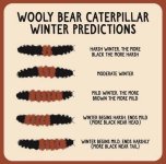
The folklore goes like this: more black is said to mean a harsher winter, while a wider rusty-brown band suggests a milder one. The woolly bear I spotted had a broad brown band, so, if we are letting the caterpillar have a vote, it is leaning milder.
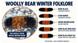
Of course, it is a fun bit of fall folklore, not a scientific forecast. But it is a perfect reminder that winter is getting closer. We are now 82 days from the winter solstice on December 21, and there is still plenty of fall to enjoy first.
In fact, we have a warm start ahead, with highs pushing the 80s before cooler air settles in later.
When it comes to the science, the big winter player is El Niño. NOAA’s Climate Prediction Center now says there is greater than a 90% chance of a very strong El Niño influencing the fall and winter season.
A stronger subtropical jet stream can bring more moisture and more opportunities for storms across the southern United States and into parts of the Mid-Atlantic.
For the Washington area, NOAA’s early seasonal outlook tilts toward a warmer-than-normal winter overall, along with a better chance for wetter-than-normal conditions. That does not automatically mean a snowy winter. Snow in D.C. still requires the timing of cold air and moisture to line up just right. One or two well-timed storms can make a winter memorable; plenty of rain can fall if the cold air is not in place.

NOAA Winter (Early Look) 2026-27
The Farmers’ Almanac is painting a more colorful, traditional long-range picture: a stormier southern tier, cold snaps and snow squalls to the north, and a rain-sleet-snow puzzle along the East Coast. Their broad theme for our region is the possibility of coastal mix and inland wet snow.

Farmers Almanac Winter 2026-27
So what should you take from all of this right now? Enjoy the woolly bear, keep an eye on El Niño, and remember that seasonal outlooks show the odds—not a day-by-day forecast.
Our official Storm Alert Weather Forecast will be out near the end of fall, when we will have more information and a sharper read on what winter could bring to D.C., Maryland and Northern Virginia.
For now, the caterpillar is calling for mild. The atmosphere is calling for moisture. And we will be watching every new signal.
Woolly Bear says mild? The science behind our winter watch
A woolly bear brings fall folklore, while a strong El Niño puts D.C. on watch for a potentially warmer, wetter season ahead.
wjla.com
Woolly Bear says mild? The science behind our winter watch
by ChiefMeteorologistVeronica Johnson
Wed, September 30, 2026 at 2:57 PM
WASHINGTON(7News) — I saw a woolly bear caterpillar the other day, and it brought me right back to my first years forecasting in Washington.
Locals would tell me that, back in the day, people would examine these little fuzzy caterpillars for an early clue about the winter ahead.
The folklore goes like this: more black is said to mean a harsher winter, while a wider rusty-brown band suggests a milder one. The woolly bear I spotted had a broad brown band, so, if we are letting the caterpillar have a vote, it is leaning milder.
Of course, it is a fun bit of fall folklore, not a scientific forecast. But it is a perfect reminder that winter is getting closer. We are now 82 days from the winter solstice on December 21, and there is still plenty of fall to enjoy first.
In fact, we have a warm start ahead, with highs pushing the 80s before cooler air settles in later.
When it comes to the science, the big winter player is El Niño. NOAA’s Climate Prediction Center now says there is greater than a 90% chance of a very strong El Niño influencing the fall and winter season.
A stronger subtropical jet stream can bring more moisture and more opportunities for storms across the southern United States and into parts of the Mid-Atlantic.
For the Washington area, NOAA’s early seasonal outlook tilts toward a warmer-than-normal winter overall, along with a better chance for wetter-than-normal conditions. That does not automatically mean a snowy winter. Snow in D.C. still requires the timing of cold air and moisture to line up just right. One or two well-timed storms can make a winter memorable; plenty of rain can fall if the cold air is not in place.
NOAA Winter (Early Look) 2026-27
The Farmers’ Almanac is painting a more colorful, traditional long-range picture: a stormier southern tier, cold snaps and snow squalls to the north, and a rain-sleet-snow puzzle along the East Coast. Their broad theme for our region is the possibility of coastal mix and inland wet snow.
Farmers Almanac Winter 2026-27
So what should you take from all of this right now? Enjoy the woolly bear, keep an eye on El Niño, and remember that seasonal outlooks show the odds—not a day-by-day forecast.
Our official Storm Alert Weather Forecast will be out near the end of fall, when we will have more information and a sharper read on what winter could bring to D.C., Maryland and Northern Virginia.
For now, the caterpillar is calling for mild. The atmosphere is calling for moisture. And we will be watching every new signal.
I only find wooly bears dried up and dead in the pole building, so it's hard to gauge the winters by them.
I can only go on long experience, and El Nino means an easy winter for those of us in the far north. (N MN). I had a confab with the snowplow guy this week and he has me on his list again this winter with the V-plow on a dually contractor dump truck. "Skid steer and bucket will travel" in reserve for bad banks and drifts if they happen. So anyway, bring it on.
I can only go on long experience, and El Nino means an easy winter for those of us in the far north. (N MN). I had a confab with the snowplow guy this week and he has me on his list again this winter with the V-plow on a dually contractor dump truck. "Skid steer and bucket will travel" in reserve for bad banks and drifts if they happen. So anyway, bring it on.
Yep. And those of us on the leeward/down wind side of the Great Lakes have NO idea what we might get! "Warmer" is good... but it also means the Lakes may not freeze, or may have open water until very late winter.Just remember, this far out the "forecast" is "generally speaking". Even where it's supposed to be milder, we can still have real cold stretches & storms. (Same goes for wooly worms!)
If the pattern includes storms from the West, as they move across the warm lakes, they pick up tons of moisture...and then dump it as snow a few miles inland.
Today is brilliantly sunny and going to barely hit 60. Gorgeous fall day for a pig roast! We still dont have any frost in the forecast (our proximity to Lake Ontario helps), but an hour South will probably see a freeze later this week.
I haven't seen a single Wooly Bear caterpillar yet...
Summerthyme
Last edited:
Blacknarwhal
Three-Time Trump Voter
I grew up south of Lakes Michigan & Erie; seen snow half way up the telephone poles (remember those?). I ain't skeerd of no winter...
Toledo?
Blacknarwhal
Three-Time Trump Voter
Yep. And those of us on the leeward/down wind side of the Great Lakes have NO idea what we might get! "Warmer" is good... but it also means the Lakes may not freeze, or may have open water until very late winter.
If the pattern includes storms from the West, as they move across the warm lakes, they pick up tons of moisture...and then dump it as snow a few miles inland.
Today is brilliantly sunny and going to barely hit 60. Gorgeous fall day for a pig roast! We still dont have any frost in the forecast (our proximity to Lake Ontario helps), but an hour South will probably see a freeze later this week.
I haven't seen a single wooly Bears caterpillars yet...
Summerthyme
Next Sunday's high out here is 78. We're talking mid-October, and a high nearly in the 80s. That's a real long shot for SW lower MI.

Sacajawea
Has No Life - Lives on TB
Nope; more central - Wayne Co.Toledo?

King Samson
I'm Here
So, we're moving on to Winter Predictions....
I'm still waiting for them to get the Hurricane forecast correct for the Atlantic Basin. They missed that one by a mile!! There's been zero Hurricanes.
NOAA's outlook for the 2026 Atlantic Hurricane Season indicates that a below-normal season is the most likely outcome, with moderate chances for a near-normal season, and low probabilities that the season could be above-normal. The outlook calls for a 55% chance for a below-normal season, a 35% chance of a near-normal season, and only a 10% chance for an above-normal season. See the NOAA definitions of above-, near-, and below-normal seasons for more information.
The 2026 outlook calls for a 70% probability for each of the following ranges of activity:
I'm still waiting for them to get the Hurricane forecast correct for the Atlantic Basin. They missed that one by a mile!! There's been zero Hurricanes.
NOAA 2026 Atlantic Hurricane Season Outlook
NOAA's outlook for the 2026 Atlantic Hurricane Season indicates that a below-normal season is the most likely outcome, with moderate chances for a near-normal season, and low probabilities that the season could be above-normal. The outlook calls for a 55% chance for a below-normal season, a 35% chance of a near-normal season, and only a 10% chance for an above-normal season. See the NOAA definitions of above-, near-, and below-normal seasons for more information.
The 2026 outlook calls for a 70% probability for each of the following ranges of activity:
- 8-14 Named Storms
- 3-6 Hurricanes
- 1-3 Major Hurricanes
- Accumulated Cyclone Energy (ACE) range of 45-115% of the median