Plain Jane
Just Plain Jane
Post what you find and we'll see whose forecast comes closest!
Aug 12, 2026 3:06 PM EDT
By Ian Greenwood
Staff Writer, Powder
As the 2026-27 ski season approaches, more attempts at making sense of the so-called “Super” El Niño—and determining what it means for snow conditions—are flowing in.
This time, meteorologist and operations manager Alan Smith of the ski-focused forecasting team OpenSnow is throwing his hat (or ski helmet) into the ring.
His latest preview notes that while the ongoing El Niño may become so strong that it goes down in the history books by a wide margin, it could still deliver on parts of the expected pattern.
In other words, per Smith’s forecast, the American Southwest has the best chances of a snowier-than-usual winter. (Check your vitamin D before winter returns)
Here’s the full breakdown from Smith.
R/T 12:55
View: https://youtu.be/ZYaec8JQKdE?si=gCuceVDUvVXGhSZB
For the uninitiated, El Niño is a phase in the El Niño-Southern Oscillation, or ENSO. The cycle, which flip-flops on an irregular, multi-year scale, revolves around a patch of ocean in the equatorial Pacific.
When those temperatures warm, and the right atmospheric signals are in place, meteorologists declare that El Niño has come to town. The opposite is true of El Nino’s sibling, La Nina.
Through “teleconnections,” El Niño and La Niña can impact weather around the globe, including in North America, where those impacts are typically most pronounced during the winter.
For El Niño, the historical pattern boosts the subtropical jet stream, leading to more moisture across the southern U.S. The opposite is true of the north, with a trend towards warm and sometimes drier conditions.
Long-range forecasting is an imperfect science. Still, meteorologists consider ENSO a valuable tool in the fickle game of guessing what a given winter will look like in advance. ENSO also isn’t the only pattern or feature Smith considered.
To build the forecast, he turned to temperature distributions in the Tropical and Atlantic Ocean and patterns other than ENSO.
His findings?
Above normal snowfall is favored for California’s Sierra Nevada, Utah, Arizona, Nevada, New Mexico, and parts of Colorado. Everywhere else in the U.S., per the forecast, is set for below-normal snowfall or equal chances that snow totals go in either direction.
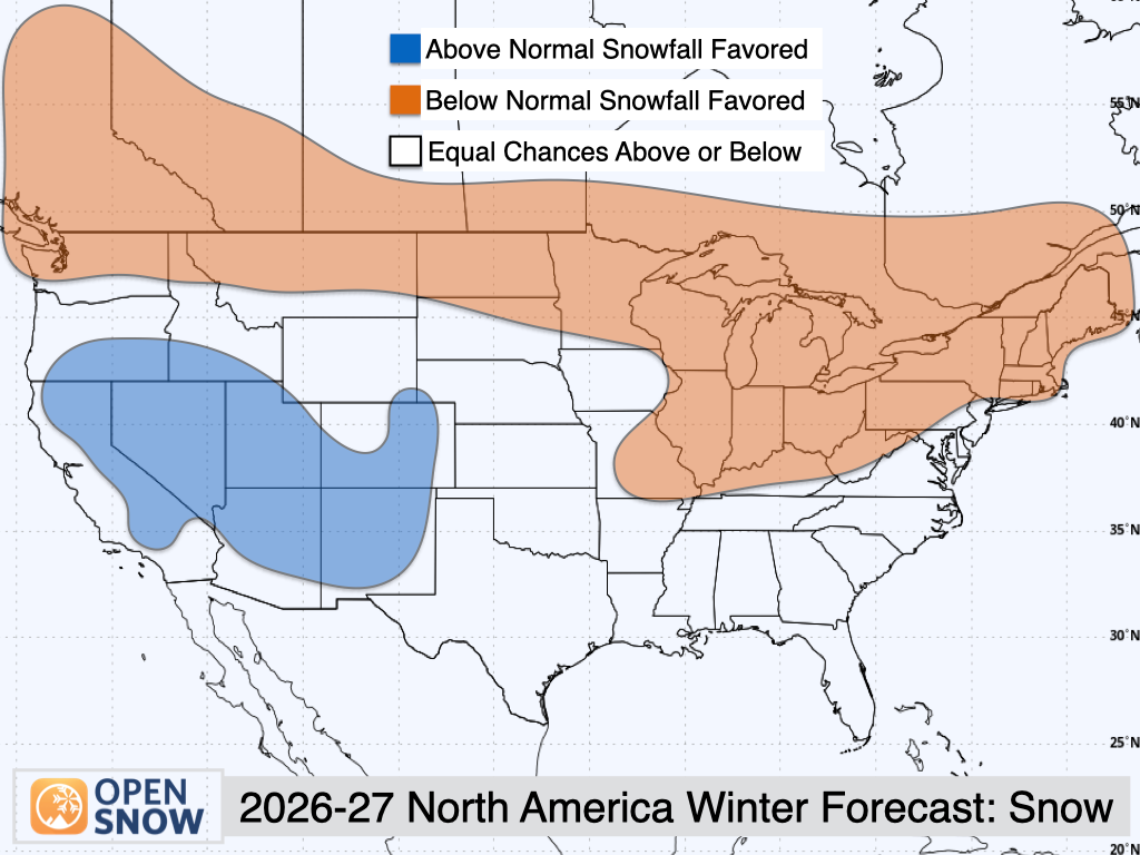
Are you a skier in the blue blob? Don’t celebrate too early, but OpenSnow is forecasting “Above Normal” snowfall for your region.
OpenSnow
Specifically, a band of predicted below-normal snowfall stretches all the way from Washington and Western Canada to the Northeast.
Interestingly, the problem here isn’t necessarily a lack of precipitation—according to OpenSnow, this northern tier (aside from Western Canada) is set for equal chances of above or below normal precipitation.
But, Smith said, “One thing you’ll notice is some areas, like Washington and Montana, we’re not really seeing any kind of dry signal here, despite the below average snowfall signal. This is indicative of the warmth we’re expecting, which can lead to average snow levels being a bit higher than what you would expect.”
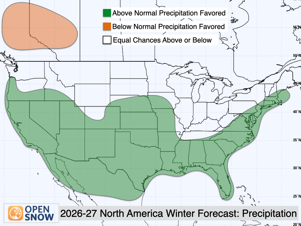
OpenSnow’s precipitation forecast shows an “Above Normal” rating for California, Nevada, Utah, parts of Colorado, New Mexico, and the entirety of the South, Southeast, and Mid-Atlantic.
OpenSnow
Smith also signed off his video with a caveat.
“Seasonal forecasts are interesting, but you should always take them with a grain of salt,” he said. There’s always going to be factors that “we can’t predict months or even weeks in advance.”
He also noted that with a potentially record-setting El Niño, there could be some surprises.
Preview Bodes Well for Some Skiers
Alan Smith of the OpenSnow crew broke down his predictions, but noted that with the potentially record-setting El Niño, there could be some surprises.Aug 12, 2026 3:06 PM EDT
By Ian Greenwood
Staff Writer, Powder
As the 2026-27 ski season approaches, more attempts at making sense of the so-called “Super” El Niño—and determining what it means for snow conditions—are flowing in.
This time, meteorologist and operations manager Alan Smith of the ski-focused forecasting team OpenSnow is throwing his hat (or ski helmet) into the ring.
His latest preview notes that while the ongoing El Niño may become so strong that it goes down in the history books by a wide margin, it could still deliver on parts of the expected pattern.
In other words, per Smith’s forecast, the American Southwest has the best chances of a snowier-than-usual winter. (Check your vitamin D before winter returns)
Here’s the full breakdown from Smith.
R/T 12:55
For the uninitiated, El Niño is a phase in the El Niño-Southern Oscillation, or ENSO. The cycle, which flip-flops on an irregular, multi-year scale, revolves around a patch of ocean in the equatorial Pacific.
When those temperatures warm, and the right atmospheric signals are in place, meteorologists declare that El Niño has come to town. The opposite is true of El Nino’s sibling, La Nina.
Through “teleconnections,” El Niño and La Niña can impact weather around the globe, including in North America, where those impacts are typically most pronounced during the winter.
For El Niño, the historical pattern boosts the subtropical jet stream, leading to more moisture across the southern U.S. The opposite is true of the north, with a trend towards warm and sometimes drier conditions.
Long-range forecasting is an imperfect science. Still, meteorologists consider ENSO a valuable tool in the fickle game of guessing what a given winter will look like in advance. ENSO also isn’t the only pattern or feature Smith considered.
To build the forecast, he turned to temperature distributions in the Tropical and Atlantic Ocean and patterns other than ENSO.
His findings?
Above normal snowfall is favored for California’s Sierra Nevada, Utah, Arizona, Nevada, New Mexico, and parts of Colorado. Everywhere else in the U.S., per the forecast, is set for below-normal snowfall or equal chances that snow totals go in either direction.
Are you a skier in the blue blob? Don’t celebrate too early, but OpenSnow is forecasting “Above Normal” snowfall for your region.
OpenSnow
Specifically, a band of predicted below-normal snowfall stretches all the way from Washington and Western Canada to the Northeast.
Interestingly, the problem here isn’t necessarily a lack of precipitation—according to OpenSnow, this northern tier (aside from Western Canada) is set for equal chances of above or below normal precipitation.
But, Smith said, “One thing you’ll notice is some areas, like Washington and Montana, we’re not really seeing any kind of dry signal here, despite the below average snowfall signal. This is indicative of the warmth we’re expecting, which can lead to average snow levels being a bit higher than what you would expect.”
OpenSnow’s precipitation forecast shows an “Above Normal” rating for California, Nevada, Utah, parts of Colorado, New Mexico, and the entirety of the South, Southeast, and Mid-Atlantic.
OpenSnow
Smith also signed off his video with a caveat.
“Seasonal forecasts are interesting, but you should always take them with a grain of salt,” he said. There’s always going to be factors that “we can’t predict months or even weeks in advance.”
He also noted that with a potentially record-setting El Niño, there could be some surprises.