You are using an out of date browser. It may not display this or other websites correctly.
You should upgrade or use an alternative browser.
You should upgrade or use an alternative browser.
Solar Grand Solar Minimum part deux
- Thread starter Dennis Olson
- Start date
-
- Tags
- grand solar minimum
Martinhouse
Deceased
We're going to be having overnight lows way down in the mid 20s in the coming days. I have bedding plants that should have been in the ground a week ago and I've put it off until this last cold spell is past. At least I hope it's the last.
I've gotten ten empty mineral tubs from a gal who works at our feed store and then bought and scrounged enough dirt, compost, etc., to fill them. They will be mainly lettuces, kale, cabagge and collards, mostly for the chickens and rabbits. Some I may dehydrate and rub into powder to add to my own food. Also I'm digging up all the dandelions I can find to move into containers of very rich soil. This will grow some monstrous dandelion leaves which is a nearly effort-free way to produce some excellent nutrition. I'm hoping dandelions will be able to more or less ignore the GSM.
I'm trying to set up all my planting so that I'm able to quickly cover things at night if we get any more of the spells that get cold enough to damage some of what I'll be planting.
This erratic weather is getting harder and harder to deal with and especially to plan ahead for. To borrow part of a phrase, "The Grand Solar Minimum sure ain't for sissies!"
Last edited:
Martinhouse
Deceased
BenIan, I think sometimes a wind can help keep a frost from settling right on the plants, but I'm not sure about wind chill that much lower than a temp that is barely above freezing.
If anyone knows about this, I'd sure like them to share any info!
If anyone knows about this, I'd sure like them to share any info!
Last edited:
TxGal
Day by day
I've learned the hard way to not plant tomatoes before tax day up here. That's just my personal experience. We get serious cold snaps here. I've tried covering them, etc., but it's always the 'surprise' drops in temps that get me.
The cold front just blew through. We were at 72, temp is down to 58 and will be 40 by morning with wind chills in the 30s. Ugh.
Martinhouse, we're doing the same thing with tubs. It's a great use of resources and it was kind of your feed store lady is giving you some, they're pretty darn tough.
The cold front just blew through. We were at 72, temp is down to 58 and will be 40 by morning with wind chills in the 30s. Ugh.
Martinhouse, we're doing the same thing with tubs. It's a great use of resources and it was kind of your feed store lady is giving you some, they're pretty darn tough.
RememberGoliad
Veteran Member
My whole garden is in. Tomatoes, peppers, eggplants, potatoes, herbs, cucumbers. Our forecast calls for a low of 34on Sunday with wind chill of 26. Very late for this weather here. Am I going to lose everything?
Plants can't feel the windchill like warm-blooded critters can. No matter how hard you blow on a glass of water, if it's 34 degrees it ain't gonna freeze. Now, that said, tomatoes do not like much below 45, so....
It just blew through here (NW of Kerrville, Tex. by some miles) and it's rearranging the stacks of stuff I have in the yard. If it'd blown this hard during the late morning, we'd have a few hens laying the same egg several times!
Came through dry....so far. Of course, that's the story of our last IDK how long. We usually get 8-12" of snow per year, this year not a flake. Been plenty cold enough, down to 12 I believe, right before Christmas, but no precipitation.
Strangely, no freeze predicted here for this week. Well, I just checked and Sunday night shows 31 for a low. That is new since this afternoon.
Had to corral the goats into the garden for a few days. Discovered a hog-sized hole in the fence furthest from the house and while they hadn't found it yet, it was only a matter of time. Didn't want them seeing me monkeying with the fence there, either, since that'd draw attention to that place, so I locked 'em up in the deer-fenced garden. All tilled up but nothing planted yet, so I'm only out a half hour of rototiller running. If it wasn't for that, there'd be stuff planted, so I guess things work out

Thanks Tx for posting! I'm not a regular on this thread but that's only because I see another squirrel and off I go charging elsewhere and barking like a fool. Then when THIS squirrel chatters at me, I'll get regular for a while....until another squirrel.... LOL! But don't think I don't appreciate your work on this!
RememberGoliad
Veteran Member
Another point I should make, and it's important enough to be standalone and not part of my ramble above, is that I'm starting to see new growth on my wild, but protected by us, patches of mullein. In a few weeks here, it'll be time to harvest and dry my supply of leaf. Some of y'all followed DW's saga last winter, and she's thriving on freshly-dried mullein tea daily, keeps her lungs clear and the gunk flowing.
Martinhouse
Deceased
TxGal, I know those cattle tubs are tough but my nephew told me the ones he had brittled and crumbled after about a year. But I found that Miracle-Gro bags seem to last forever hanging in the sun, so since I save everything possible that could be of use some day, I've been able to cut apart enough of the large-size bags that I will clip around the tubs, white inside showing, with binder clips. Bags are big enough cut open the long way to wrap all the way around the whole outside of the tub plus tuck down inside to below the dirt line so that will keep out the UV. Each tub has a drain hole drilled on the side a few inches above the bottom.
I wish I could afford blocks and boards to raise them above ground level, but I do at least put them on strips of discarded black tarps that were used to cover semi truck loads until they became too worn to be repaired.
I wish I could afford blocks and boards to raise them above ground level, but I do at least put them on strips of discarded black tarps that were used to cover semi truck loads until they became too worn to be repaired.
Last edited:
TxGal
Day by day
Martinhouse, that's interesting about your tubs, most of ours last pretty well, at least a few years before we spot a crack at the bottom (which for gardening is great)...ours aren't brittle at all. Must be the brand we buy. Great ideas, though!
We got through the storms okay last evening. Wasn't fun, had a lot of rain and wind, but I'm hoping tree damage is minimal. Kinda figured anything that was going to go went in the last two storms, the big ice storm that knocked out our power for 5 days, and then a straight-line wind storm of an estimated 80 mph. Pastures are squishy, though...mud season.
We got through the storms okay last evening. Wasn't fun, had a lot of rain and wind, but I'm hoping tree damage is minimal. Kinda figured anything that was going to go went in the last two storms, the big ice storm that knocked out our power for 5 days, and then a straight-line wind storm of an estimated 80 mph. Pastures are squishy, though...mud season.
TxGal
Day by day
Bicoastal Snowstorms Pummel U.S.; Feet Of Additional Snow Pound The European Alps; Moscow Drifts; + Polar Radio Blackout *Finally* Subsiding - Electroverse
A sign of the times...

BICOASTAL SNOWSTORMS PUMMEL U.S.; FEET OF ADDITIONAL SNOW POUND THE EUROPEAN ALPS; MOSCOW DRIFTS; + POLAR RADIO BLACKOUT *FINALLY* SUBSIDING
MARCH 16, 2023 CAP ALLONBICOASTAL SNOWSTORMS PUMMEL U.S.
More than half a million Americans were without power at one point Wednesday, after bicoastal snowstorms prolonged the winter of 2022-23.In California, some 40 of the state’s 58 counties have been put under a state of emergency as another atmospheric river hits; while switching coasts, over 4 feet of mid-March snow settled in parts of New York, New Hampshire and Massachusetts.
The nor’easter delivered mounds of snow, downed power lines and toppled trees — it closed hundreds of schools and businesses and put New York state and multiple counties in New Jersey under states of emergency.
View: https://twitter.com/brm90/status/1636154869772959744
California is experiencing its eleventh atmospheric river since December.
And looking ahead, “the extended range outlook from the Climate Prediction Center forecasts another atmospheric river arriving next week,” according to the National Weather Service, and backed up by latest GFS runs:

GFS Total Snowfall (inches) March 16 – March 31 [tropicaltidbits.com]
Heavy snow is sweeping Colorado, too. Feet are hitting the mountains, with disruptive flurries now reaching the Denver metro area, threatening to impact the Thursday morning and afternoon commutes.
A winter weather advisory went into effect starting at 3PM Wednesday for mountain communities, including in Rocky Mountain National park. Advisories are also in effect for Rabbit Ears Pass where the heaviest snow was seen Wednesday.

Windy and cold conditions will remain in Denver through the weekend, with further snow possible in Denver Sunday.
By the end of this event, well-over 2 feet of snow will have accumulated across Colorado’s higher elevations, including the Elkhead and Park Mountains, the Sawatch Mountains, and Colorado’s San Juans.
View: https://twitter.com/DenverChannel/status/1636195077851586561
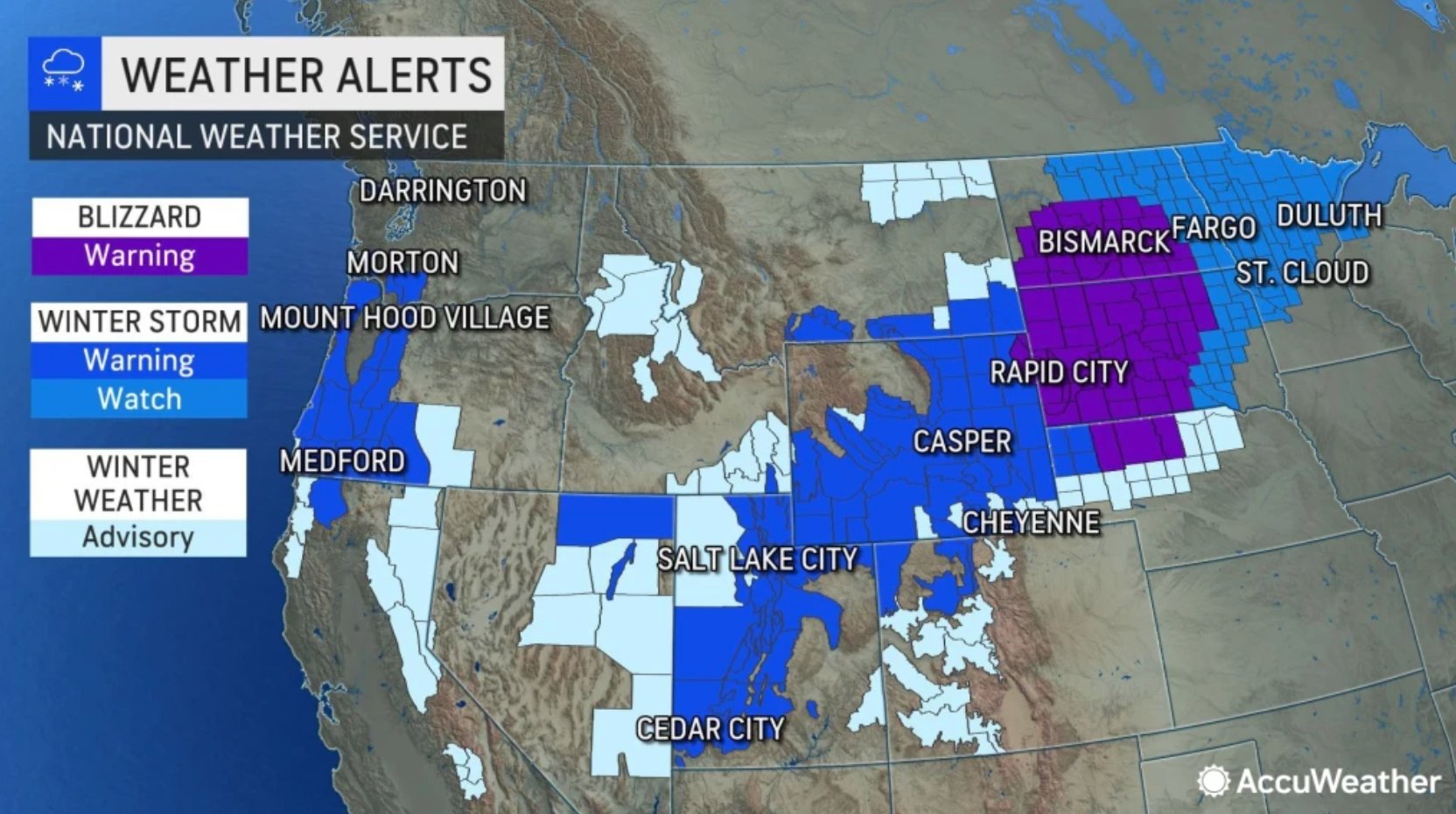
Not to miss out the Midwest, another powerful storm is expected to dump several inches of snow across the northern Plains and Upper Midwest to close out the week, adding to what is already the 8th snowiest winter in the Minneapolis area.

This week’s snow is forecast to jump the winter of 2022-23 into 5th place, displacing 1916-17 (the Centennial Minimum).
The temperatures will prove disruptive, and all, ranging from the low to mid-20s from Billings, Montana and Casper, Wyoming, through South Dakota. While farther north, the mercury will hold in the upper teens in Bismarck and Fargo, North Dakota.
The snowfall will increase in the Upper Midwest into Thursday, while the storm will be winding down for the likes of the Dakotas and Rockies. A swath of snow is expected to develop from central and northeastern Nebraska all the way through northwestern Iowa, Minnesota and northwestern Wisconsin on Thursday, with overnight flurries set to continue in eastern Minnesota, including Minneapolis and Duluth, as well as northern Wisconsin and Michigan‘s Upper Peninsula.
Winter weather alerts stretch from the Plains to the Upper Midwest, and run through the weekend for many.
Winter storm warnings stretch from northeastern Nebraska through southeastern South Dakota, northwestern Iowa, southwestern, central and northeastern Minnesota, northern Wisconsin and Michigan’s Upper Peninsula.
Northeastern Minnesota will see a foot of snow and blizzard conditions, with northern Wisconsin and the UP of Michigan seeing higher totals. Marquette, Michigan, for example, could pick up over 2 feet by the time the system exits over the weekend.

After these latest rounds of snow, ECCC may need to draw a new chart.
“It’ll be cold [too] — cold for March,” says Paige Marten, a NWS meteorologist — thanks Paige.
FEET OF ADDITIONAL SNOW POUND THE EUROPEAN ALPS
It’s snowing again in the Alps. The latest dumpings are arriving hot on the heels of the huge snowfalls in France as well as ski areas in Austria, Italy and Switzerland last weekend.This week’s snow is proving more widespread than the weekend falls, reports inthesnow.com, with areas further east posting substantial accumulations even down to the valley floor.

Obergurgl on March 14
Last weekend’s snowstorm brought 1.5 meters (5 feet) to ski areas in the northern French Alps.
Avoriaz, Cervinia, La Rosiere and Tignes were among the resorts posting the biggest jumps in their upper slope base depths (at 1m/3.3ft each). As a result, the avalanche danger has been increased to level 4 (of 5) on many slopes.
MOSCOW DRIFTS
“The closer to summer, the higher the snowdrifts” reports Russian weather website hmn.ruHeat is in no hurry to settle in the capital region, continues the site, as thick clouds continue to deliver snow to Moscow’s streets.
This week has seen the city’s snow cover grow again, holding the snowpack higher than usual for the time of year. Last year, snow depth was 16 cm (6.3 inches) on March 14; this year, however, March 14 delivered a depth of 40 cm (15/7 inches).

POLAR RADIO BLACKOUT *FINALLY* SUBSIDING
Following March 13’s “extremely rare” farside CME, shortwave radios inside the Arctic Circle are working again after a 3-day blackout.The blackout is called a “polar cap absorption event” or PCA, explains Dr. Tony Phillips of spaceweather.com, caused by energetic protons accelerated toward Earth by the violent coronal mass ejection (CME).
Those protons are now ebbing, meaning normal propagation of shortwave radio signals can resume.

MINOR CME IMPACT SPARKS NORTHERN AND SOUTHERN LIGHTS
Had Monday’s CME not been a farside event, had the discharge instead been Earth-directed, it would have caused untold disruption.The electrical grid that our modern civilization has become utterly dependent on would be no more, at least on the sun-facing side of the planet, with it perhaps being years before the power could be reestablished, particularly in rural areas — that is, if society doesn’t completely fold in on itself during the ensuing blind Biblical-like panic.
Earth’s magnetic field is weakening, has been since the 1800s.
Coronal mass ejections striking our atmosphere are having a larger and larger impact.
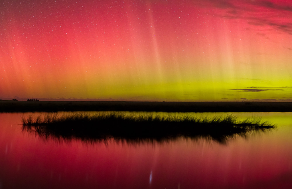
Monday’s CME would have proved catastrophic if Earth-direct. This is shown by even minor ejections, such as that which struck our magnetosphere on March 15, sparking geomagnetic storms and also strong auroras over both ends of our planet.
That is, the North:

Roman Banas photographed these red auroras near Bydgoszcz, Poland: “You could see the rays with the naked eye,” says Banas. “It was strongest around midnight.”
And the south:

Almost 18,000 km away from Poland, a remarkably similar filled the skies above Lake Ellesmere, New Zealand.
Photographer Mike White: “A strong glow persisted for an hour or so on the southern horizon with occasional periods of bright rays extending upwards.”
Being days away from the March equinox, this is the time of year when Northern and Southern Lights can be seen at the same time. Nearly equal amounts of darkness allow sky watchers in both hemispheres equal opportunity to witness auroras, explains Dr. Phillips.
The CME that struck Earth on March 15 was caused by a magnetic filament erupting on the Sun (shown below) almost 4 days earlier. Though weak, its arrival sparked a series of alternating G1 and G2-class geomagnetic storms — a sign of the times.


My whole garden is in. Tomatoes, peppers, eggplants, potatoes, herbs, cucumbers. Our forecast calls for a low of 34on Sunday with wind chill of 26. Very late for this weather here. Am I going to lose everything?
I would think order of vulnerability would be the eggplants then cucumbers, peppers and tomatoes. Just throw some old sheets, towels, tarps, etc. over them - don't let the baby plants touch the coverings though, leave a gap. I usually just take my tomato cages and lay them down sideways over the baby plants and that usually gives a good frame to drape coverings over them. Then weigh the tarps, etc. down with rocks, logs, or whatever so the wind doesn't blow them off.
I'm in central Maryland and an old neighbor that used to live behind me always said "Never plant before St. Patty's day, but that being said if you don't lose a few plants to frost every year, you aren't planting soon enough." In other words you can always replant (well in a normal, non-solar minimum, non volcano belching water vapor into the atmosphere-year LOL).
edited for spelling.
Last edited:
northern watch
TB Fanatic
From my email inbox The Old Farmer's Almanac March 17 2023

BenIan
Veteran Member
I try not to plant to early but I'm on the Gulf coast...I've only seen one frost/freeze this late and that was in 1992 or 1993 when it snowed in early April. I can cover a few things, and will, but I've got way too much in the ground to cover it all.I would think order of vulnerability would be the eggplants then cucumbers, peppers and tomatoes. Just throw some old sheets, towels, tarps, etc. over them - don't let the baby plants touch the coverings though, leave a gap. I usually just take my tomato cages and lay them down sideways over the baby plants and that usually gives a good frame to drape coverings over them. Then way the tarps, etc. down with rocks, logs, or whatever so the wind doesn't blow them off.
I'm in central Maryland and an old neighbor that used to live behind me always said "Never plant before St. Patty's day, but that being said if you don't lose a few plants to frost every year, you aren't planting soon enough." In other words you can always replant (well in a normal, non-solar minimum, non volcano belching water vapor into the atmosphere-year LOL).
Cover a few of each type plant, so if they are wrong, and you actually get a frost, you'll have some of each veggie early while waiting for the replacement plants to mature.I try not to plant to early but I'm on the Gulf coast...I've only seen one frost/freeze this late and that was in 1992 or 1993 when it snowed in early April. I can cover a few things, and will, but I've got way too much in the ground to cover it all.
That said, I suspect your soil temps are warm enough that the air temp within a couple feet of the ground will be enough warmer that even an official 32° reading won't hurt them. However, if you DO get hit, get up before sunrise and spray the plants with water... it prevents the secondary damage that the sun hitting frozen foliage causes. We've saved sweet corn with this method a couple times.
Meanwhile, we're hoping the heavy rain we're getting will melt the 14" of snow from the last storm. DS built a cold frame for one of the 8 foot square raised beds yesterday, but we'd have to shovel it off to install it!
Summerthyme
TxGal
Day by day
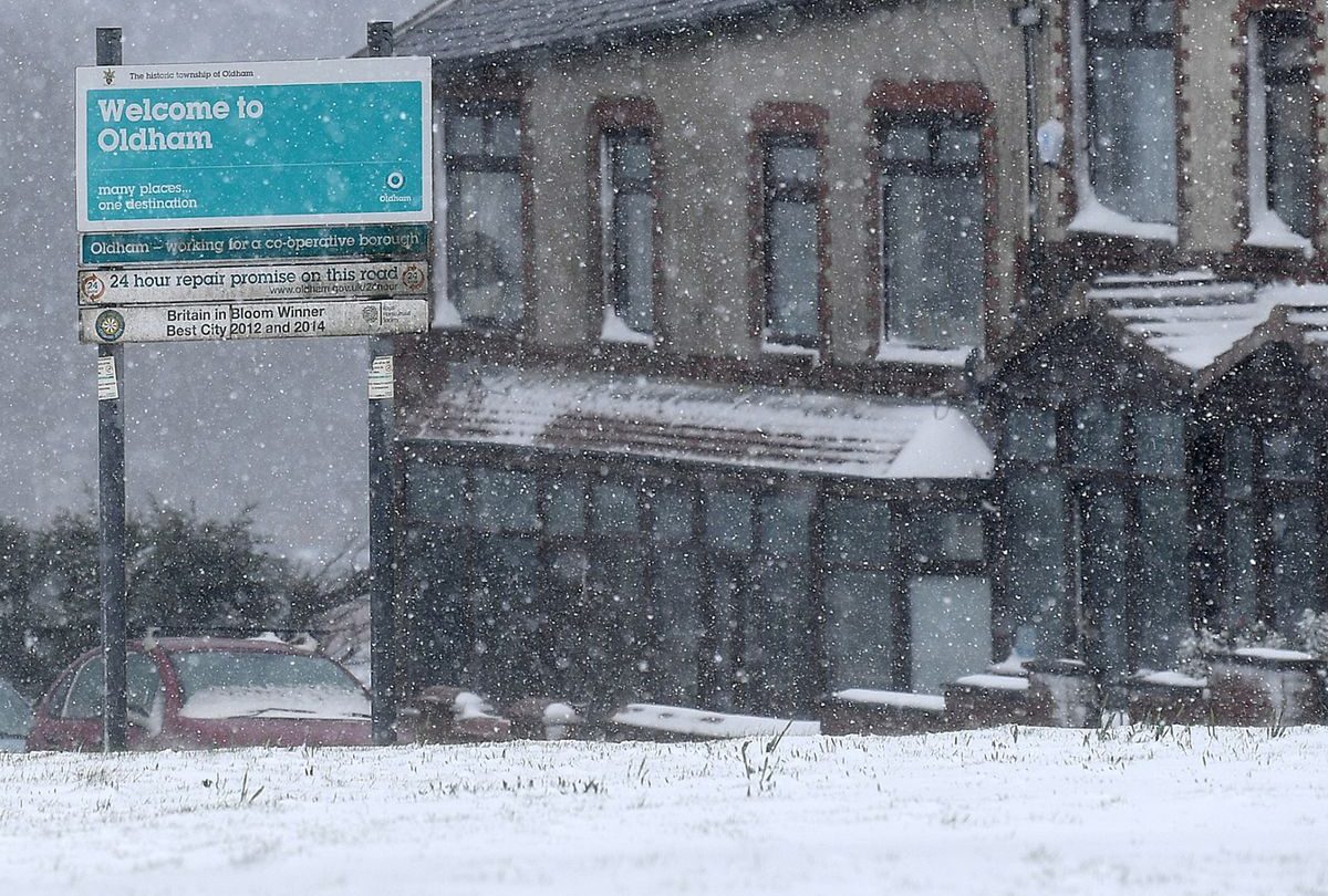
Deadly Avalanches In Europe; Cold Februaries For Dominica And Barbados; Brits In The Cold And Dark Due To Soaring Energy Prices-As Gov Seeks To *Further* Extend Life Of Aging Coal Power Plants - Electroverse
The UK is doomed, but not by the hand of Russia or the existential threat that 'catastrophic global warming' is claimed to be; rather by its own hand, by its own weakness, gullibility, and pathetic placating to the globalist elites.

DEADLY AVALANCHES IN EUROPE; COLD FEBRUARIES FOR DOMINICA AND BARBADOS; BRITS IN THE COLD AND DARK DUE TO SOARING ENERGY PRICES–AS GOV SEEKS TO *FURTHER* EXTEND LIFE OF AGING COAL POWER PLANTS
MARCH 17, 2023 CAP ALLONDEADLY AVALANCHES IN EUROPE
Following the impressive European snows, avalanches are hitting.Earlier this week, a 28-year-old Dutch skier was killed near the ski resort of Nendaz, Switzerland.
The victim had been skiing off-piste with two friends on in an area known among Freeriders as ‘Stairway to Heaven’ when the avalanche was triggered. His friends located the man, dug him out, and contacted search and rescue, which tried resuscitation, to no avail.
On Wednesday, a separate, massive avalanche hit near the Col de Gentianes, also Nendaz.
The 1,300 feet wide slip led to an extensive search and rescue effort involving eight rescue helicopters and several search dogs. Ten skiers were caught up in the avalanche, but all were able to free themselves — all but one; tragically, the extended search and rescue efforts found a Russian skier, aged 58, for whom help came too late.

Wednesday’s fatal avalanche in the Swiss Alps.
The avalanche danger in the Swiss Alps, at Level 4 (of 5) in many parts: “The situation remains tense and dangerous; be very careful,” wrote the Institute for the Study of Snow and Avalanches (WSL) on Twitter.
COLD FEBRUARIES FOR DOMINICA AND BARBADOS
The Caribbean has been holding anomalously cool for months now, and February proved no different.Last month, Dominica, a mountainous Caribbean island nation with natural hot springs and tropical rainforests, closed with an average temperature of 25.15C, which is 0.35C below the multidecadal norm.
Likewise in Barbados, February 2023 had an average temperature of 25.8C, which is 0.3C below norm.
Rare 'Snow Rollers' Spotted In Northern Ireland; Cold February Across Western Europe; Cool Caribbean; + California: Extreme Drought To No Drought In Four Months Thanks To Historic Snow - Electroverse
...but the ambulance-chasing alarmists are all aboard the next "climate catastrophe": flooding!
BRITS IN THE COLD AND DARK DUE TO SOARING ENERGY PRICES…
New research reveals that more than half of people living in Scotland are spending their time in the cold and dark for fear of rising household bills during the ongoing ‘cost of living crisis’.The report found that 51% of people across the country are having to keep lights and heating switched off, despite the recent sharp drop in temperatures, in a bid to save money.
With some 64% of Generation Z who work from home having to do so in the cold, with the lights off, while those aged 65 and over the most concerned about the energy issues, highlighting the cross-generational impact the crisis is causing.
Gas and electricity bills have soared over recent months and the UK government’s Energy Bills Support Scheme is set to end at the end of March, putting further pressure on households.
Commenting on the findings, Steve Mariner, Group Sales & Marketing Director at Barratt Developments, said: “The cost of living crisis is continuing to affect people across the country. It’s worrying to hear of people living in the cold and dark to save money on bills.”
Separate research on 2,000 Brits found that there has been a rise in consumers returning to the things that their grandparents did to save money on utility bills, such as bringing back thermals and draft excluders: 58% of respondents said they are wearing thermal tops and bottoms to avoid putting on the heating, with many turning-off radiators in under-used rooms (57%), buying draft excluders (40%) for the bottom of doors, and others putting up heavy curtains over doors and windows (41%).
This is the once prosperous United Kingdom, bowing to the anti-human climate mob and suffering the consequences.
…AS GOV SEEKS TO *FURTHER* EXTEND LIFE OF AGING COAL POWER PLANTS
Britons, as well as citizens across much of the developed world, are seeing their living standards plunge due to irrational concerns of a collapsing climate/ecosystem due to ‘too much human prosperity’ (i.e. CO2 emissions).Fears of the end of the world have been pounced upon and milked by a blood-thirsty cabal of power-hungry totalitarians; pure evil hellbent on the pursuit of unhappiness and globalization, with which comes a demotion of the middle class to the status of proles.
Using the UK again as the example, the country has completely lost its way and the plot.
From COVID to the climate, people have shown themselves to be vacuous, unquestioning husks of human begins, blindly compliant sheep that have bought The Narrative hook line and sinker without the processing of a single critical thought.
They follow the script handed down by the globalists, which is fed to them by a puppet regime and its MSM lapdogs — a government now under increasing pressure to balance both the wills of its masters and quell dissent among its citizenry.
Case in point: To avoid disaster next winter, the UK National Grid is seeking to keep its aging coal power plants on standby for another year. This is in order to ensure sufficient electricity supplies as current renewable technology continues to prove ‘net zero’ nothing but a suicidal, peasant-bashing pipe dream.
This, at least, is the aim of the National Grid; however, the plants’ operators, EDF and Drax, said they are unlikely to be able to meet the request.
Britain has set itself a target to close its coal-fired power plants by October 2024, but EDF and Drax brought that deadline forward to Sept 2022. The UK government worked a deal to keep the plants open for the 2022-23, and it was a good job they did, as during an anomalous freeze in early March the plants were called upon to support the country’s high heating demand.
The UK now wants these plants to remain open for next winter (2023-24), but both EDF and Drax have poured cold water on this.
EDF is planning to close its two remaining coal units at the West Burton A plant on March 31, 2023, claiming in a statement, “There are a number of workforce and operational reasons that mean extending the life of West Burton A again is very challenging” (which sounds like pre-negotiation spiel in order to rip a weak, hapless government of more tax payer cash).
Drax, similarly, said its coal units will close at the end of March 2023 as planned: “With a number of certifications expiring on the coal-fired units, the units would not be able to operate compliantly for winter 2023,” Drax said in a statement.
Britain has a target of net zero by 2050. But net zero isn’t zero. When you boil it down, all ‘net zero’ means is that if you’re wealthy enough to offset your carbon emissions then you can continue doing whatever the hell you like, living as exuberantly as you fancy. This is how Bill Gates et al. justify their globe trotting adventures via private jet. And, as always, it will be us proles that suffer — the 99% will limit their already meager ‘carbon footprint’ in order sell the offset so as to afford necessities, like food.
This worsening ‘cost of living crisis’ is preparing people for a bleak future of lacking and, ultimately, poverty.
The UK is utterly doomed, but not by the hand of Russia or the existential threat that ‘catastrophic global warming’ is claimed to be; rather by its own hand, by its own weakness, gullibility, and pathetic placating to the globalist elites. And all it seems the sheeple are capable of doing, psychologically bludgeoned as they are, is stand idly by and meekly curtain twitch the shifting paradigm from their unheated, unlit homes.
TxGal
Day by day
America Breaks Hundreds Of Low Temperature Records; European Frosts; + Coronal Hole - Electroverse
Rug up America. And cover those crops.

AMERICA BREAKS HUNDREDS OF LOW TEMPERATURE RECORDS; EUROPEAN FROSTS; + CORONAL HOLE
MARCH 20, 2023 CAP ALLONAMERICA BREAKS HUNDREDS OF LOW TEMPERATURE RECORDS
A full-blown Arctic Outbreak gripped much of the U.S. over the weekend — one that continues to be felt.Hundreds of low temperature records were felled on Sunday alone.
The below graphic depicts those to have fallen from 7:00 AM on March 19 to 6AM March 20 (UTC):

The breadth of the cold is noteworthy, with daily record lows falling from Idaho to Florida.
This was the descending mass of polar air responsible:

GFS 2m Temperature Anomalies (C) March 17 – 20 [tropicaltidbits.com].
And there’s more where that came from, due to hit early next week…

GFS 2m Temperature Anomalies (C) March 25 – 28 [tropicaltidbits.com].
…with impressive spring snowfall totals to boot:

GFS Total Snowfall (inches) March 20 – April 5 [tropicaltidbits.com].
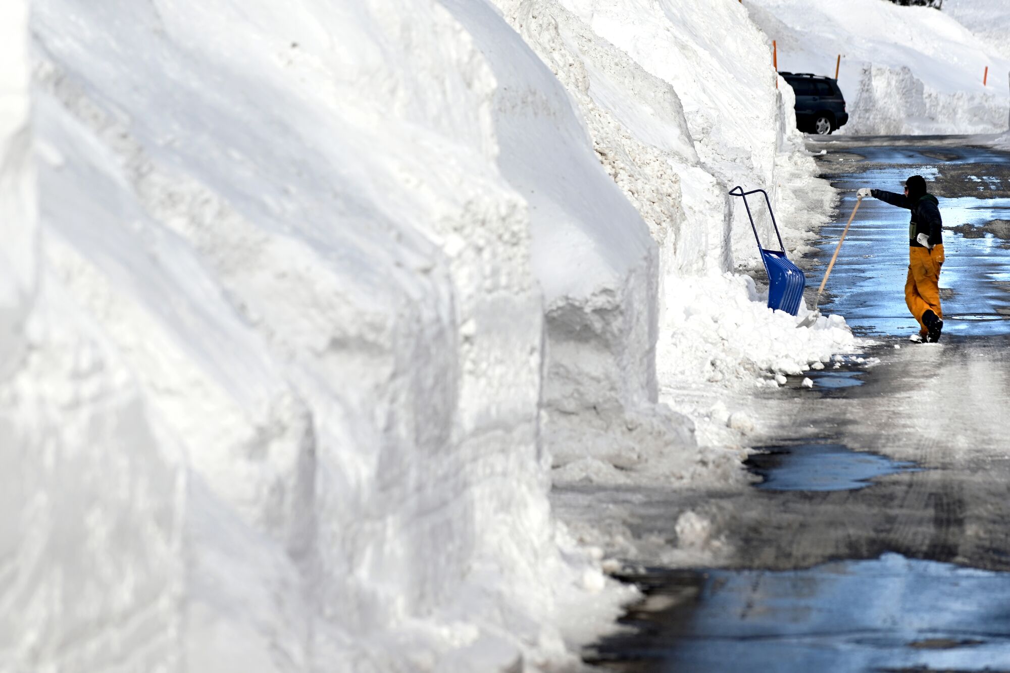
As has been well documented, it simply won’t stop snowing across the Western U.S. with all-time benchmarks tumbling across the likes of California and Utah. Here, avalanches are commonplace and buildings are buckling under the weight of the snow.
A string of snowstorms pounded California in January and then again in March, bringing monstrous totals and causing widespread damage, power outages, and monstrous totals.
Below is a before and after shot of the ski lifts at Bear Valley:
(Facebook post I can't bring over)
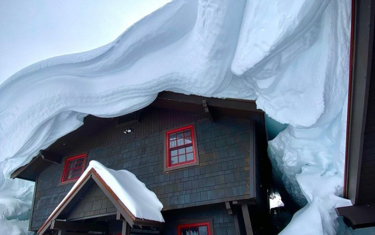
While in Tahoe, it’s proven impossible for residents to stay on top of snow clearing, leading to collapsed roofs.
While in Tahoe, long time ski film maker Scott Gaffney has been posting incredible images of accumulations there:
(Instagram post I can't bring over)
This is the story across California’s higher elevations.
That is, record-smashing snowfall totals, from UC Berkeley Central Sierra Snow Lab to Kirkwood Mountain Resort, from Bear Valley to Mammoth–with the latter posting 618 inches at its base (Main Lodge) so Lord only knows what’s up top.
Similarly in Utah, Alta ski resort has received some 681 inches to date.
While neighboring Snowbird has close to 625 inches with the resort already extending its season.
(facebook post I can't bring over)
Solitude and Brighton in Cottonwood Canyon are also boasting huge numbers.
Solitude has 623 inches, but its Brighton for the win with its whopping 699 inches — with yet more to come.

Insta: @scottgaffski
March 20 may mark the vernal equinox, and so the onset of spring, but its winter-like lows and record-breaking cold that are the prevailing weather conditions sweeping the United States.
The Twin Cities, for example, just wrapped up its coldest St. Patrick’s Day weekend since the early 1990s. And even in the Southeast, temperatures are set to hit sub-freezing levels Monday morning, with parts of Tennessee dipping below 20F (-6.7C).
“Record-breaking cold across the Southeast Monday morning to lead to widespread and potentially harmful freezing temperatures,” the Weather Prediction Center (WPC) announced Sunday.
Rug up America.
And cover those crops.
EUROPEAN FROSTS
Very cold conditions are persisting across areas of Europe, particularly the Iberian Peninsula and the south/southeast.In Italy, for example, frosts are still sweeping the nation’s low elevations, even in Sicily — incredibly rare mid/late-March.
Recently, freezing lows have been registered here, with -0.6C (30.9F) posted in the usually mild Noto area.
Looking ahead, conditions are threatening to turn colder for the majority of the continent by the end of March:

GFS 2m Temperature Anomalies (C) March 27 – 29 [tropicaltidbits.com].
With the likes of the UK expecting spring snow, with additional feet forecast across the Alps:

GFS Total Snowfall (cm) March 26 – April 4 [tropicaltidbits.com].
Deadly Avalanches In Europe; Cold Februaries For Dominica And Barbados; Brits In The Cold And Dark Due To Soaring Energy Prices-As Gov Seeks To *Further* Extend Life Of Aging Coal Power Plants - Electroverse
The UK is doomed, but not by the hand of Russia or the existential threat that 'catastrophic global warming' is claimed to be; rather by its own hand, by its own weakness, gullibility, and pathetic placating to the globalist elites.
CORONAL HOLE
The Sun was relatively inactive over the weekend. Sunday saw just 38 spots peppering the Earth-facing solar disk, with activity confined to the farside.Today, however, a large hole has opened in the sun’s atmosphere. One that’s spewing a stream of solar wind toward Earth.
NASA’s Solar Dynamics Observatory photographed the structure on March 20:
This is a “coronal hole”, explains Dr Tony Phillips of spaceweather.com — a region in the sun’s atmosphere where magnetic fields open up and allow solar wind to escape. It looks dark in the above ultraviolet image because the glowing-hot gas normally contained there is missing.
The solar wind from said hole will reach Earth later this week, on either March 23 or 24, only a few days after the vernal equinox. Expect a good display of high-latitude auroras.
TxGal
Day by day

Yesterday, Nowhere In United States Reached 80F; Snowfall Records Tumble; EU To Extend 'Energy Crisis Measure' Through Next Winter - Electroverse
They want us desperate, powerless, hungry and cold, serfs bound until death by a cripplingly unfair system -- and they're getting there.

YESTERDAY, NOWHERE IN UNITED STATES REACHED 80F; SNOWFALL RECORDS TUMBLE; EU TO EXTEND ‘ENERGY CRISIS MEASURE’ THROUGH NEXT WINTER
MARCH 21, 2023 CAP ALLONYESTERDAY, NOWHERE IN UNITED STATES REACHED 80F
Following Sunday’s myriad of cold records, the United States set a host more on Monday — largely confined to the southeast:
On March 20, zero stations in the Lower 48 reached 80 degrees Fahrenheit (27C), an incredibly rare feat for the time of year. The highest readings were the 79F (26.1F) logged at one station in Florida and four stations in California.
Looking ahead, additional rounds of plunging polar cold are on the cards as spring 2023, for many, refuses to sprung:

GFS 2m Temperature Anomalies (C) March 20 – April 6 [tropicaltidbits.com].
SNOWFALL RECORDS TUMBLE
Along with the biting cold, America’s spring snow is also proving historic.With a fresh dumping of 7.7 inches (19.6 cm), the Central Sierra Snow Lab at Donner Pass, CA has now received 677 inches (17 meters) of snow since this season, making it the second snowiest season since records began in 1946.

The resort is 135 inches shy of the all-time record held by 1951-52 year, but with yet more heavy spring snow in the forecast, I wouldn’t bet against this season pipping that top spot.

@ThierryGooseBC
Winter alerts stretch through the Sierra Nevada and San Gabriel mountains through Wednesday for heavy snow and gusty winds. Winter storm watches, warnings and advisories are in place across Northern California, for the Sierra Nevada.
Totals will be sizable in the northern Sierra, but even southern California could see accumulations of 2+ feet.

GFS Total Snowfall (inches) March 21 – April 6 [tropicaltidbits.com].
EU TO EXTEND ‘ENERGY CRISIS MEASURE’ THROUGH NEXT WINTER
Central Europe got off lightly this winter season — it was generally mild and energy reserves held up well.Soaring prices also helped demand, curbing industrial and residential usage alike–as European’s simply couldn’t afford to heat their homes.
Saying that, this past winter was a cake walk — it could have been a lot worse, all things considered.
However, as the energy CEOs have long alluded to, it will be next winter (2023-24) that proves the real crisis point.
In line with this fear, the European Commission is planning to extend its emergency measures to curb gas usage for another 12-months, “to help Europe get through next winter with scarce Russian gas”.
The ask is that countries curb their gas demand by 15% from April 2023 to at least March 2024.
Such extreme measures are required if countries are to fill their gas storage to 90% of capacity by November, so says the Commission — a binding target EU countries agreed to last year in order to avert winter shortages.
The establishment continues to target the ‘greenist’ of energies (i.e. natural gas and nuclear). This demonstrates, at least to me, that the aim here is not to avoid hardship or ‘save the planet’, but rather to decimate the West’s living standards via an all-out attack on the availability of, or access to, cheap and reliable energy — the backbone of human prosperity.
They want us desperate, powerless, hungry and cold, serfs bound until death by a cripplingly unfair system — and they’re getting there.
TxGal
Day by day
Cars Entombed In Ice; Spring Blizzards Sweep Southern California; Crop-Wrecking Mid-March Snow Hits J&K, India; + Prof. David Dilley: "Winters Beginning to Revert Back to Pre-1982 Weather Patterns Around The World" - Electroverse
"Winters will become colder, longer lasting and more severe ... it's going to be very cold."

CARS ENTOMBED IN ICE; SPRING BLIZZARDS SWEEP SOUTHERN CALIFORNIA; CROP-WRECKING MID-MARCH SNOW HITS J&K, INDIA; + DAVID DILLEY: “WINTERS BEGINNING TO REVERT BACK TO PRE-1982 WEATHER PATTERNS AROUND THE WORLD”
MARCH 22, 2023 CAP ALLONCARS ENTOMBED IN ICE
This past weekend, a winter storm rolling over Lake Erie and Buffalo coated the area in thick ice and heavy snow.This has been the story for the likes of Buffalo this winter. So far, the city’s official snow totals have touched 133.3 inches — that’s 44.1 inches above average — and although the calendar reads spring, further accumulations are to be expected.
@BuffaloWeather and @BuffaloSnowKing shared footage of the recent icy scenes:
View: https://twitter.com/weather_buffalo/status/1637460059729821698
Run time is 0:21
View: https://twitter.com/BuffaloSnowKing/status/1637546513629945857
Run time varies from 0:20 to 0:30
SPRING BLIZZARDS SWEEP SOUTHERN CALIFORNIA
Another atmospheric river delivered heavy snow to the San Gabriel Mountains in Southern California Tuesday.The snow caused low visibility on roads and motorists were urged to postpone travel.
The below video, shot by a Caltrans Distract 8 camera, shows an impassible State Route 2:
View: https://twitter.com/WeatherNation/status/1638344749575749634
Run time is 0:21
This season has etched its way into the history books as the snowiest on record across many California mountains and resorts.
Over the past weekend, the “winter that just doesn’t want to end”, as the NWS in Reno put it, delivered yet more snow, pushing the Central Sierra Snow Lab’s totals to 677 inches with the all-time record, set in 1951-52, in sight.
For this winter to overtake that all-time record, another 135 inches needs to fall — a tall ask, but not impossible.
“Historically, some of our big seasons have continued to be active right on through the end of spring,” said Tim Bardsley, senior hydrologist for the NWS in Reno. Sometimes snow continues falling in the Sierra well into June.
“There’s basically nothing that would indicate just because we’ve been this active, we would then transition the other direction,” Bardsley continued. “I’d almost say the opposite is more likely to be true.”
Several of California’s snowiest winters on record received 25+% of their snow after March 15. For example, the fourth-snowiest winter on record, the season of 2010-11, saw 225 inches of its 643 total (or 35%) post-March 15.
Looking at this latest forecasts, this season may be headed the same way:

GFS Total Snowfall (inches) March 22 – April 7 [tropicaltidbits.com].
View: https://twitter.com/Don_Penim/status/1638272823885205504
CROP-WRECKING MID-MARCH SNOW HITS J&K, INDIA
Fresh snowfall this week has hit the upper reaches of India’s Doda district in Jammu and Kashmir, leaving farmers assessing the damage to blooming fruit crops.Heavy and persistent snowfall, of as much as a foot, swept the district’s higher elevations on Monday, closing long stretches of road, such as a 30 km stretch on Bhaderwah-Chamba and a 25km stretch on Bhaderwah-Basohli.
officials have also issued advisories urging people not to venture out, particularly near avalanche-prone areas.
Farmers, especially fruit growers, are counting the costs of the ‘return of winter’.
“We have already started plowing our maize fields and were expecting to have a good crop of apricot, almond, peach and walnut as these trees were in the bloom,” said Saif Din Dhakkar, a farmer of village Kota Top, adding that the unseasonable snowfall and the sudden, unexpected plunge in temperatures have ravaged the fruit-bearing trees.
Run time is 0:54
Last week, many popular tourist destinations, such as Tsomgo Lake, Nathula pass, Baba Mandir, Gurudongmar Lake and Yumthang valley, were completely cut off from the state capital.
Some 1,000 tourists were stranded along a particularly snowy stretch of J N Road. They took sheltered in an army camp overnight and were successfully rescued the following morning. Similarly, another 175 tourists were rescued from different parts of North and East Sikkim as anomalously-heavy spring snowfall sweeps Northern India.
“Many tourists were stranded, so we have stopped issuing passes for three days,” said a tourism official. “We expect some snowfall during this time of the year. But this time, it was heavy,” he added.
PROF. DAVID DILLEY: “WINTERS BEGINNING TO REVERT BACK TO PRE-1982 WEATHER PATTERNS AROUND THE WORLD”
GlobalWeatherOscillations.com (GWO) and GlobalWeatherCycles.com have released their 2023-24 winter outlook for North America and Europe. The forecast, prepared by GWO’s senior research scientist Professor David Dilley, calls for COLD.As predicted by Prof. Dilley, the past winter of 2022-23 across Europe was relatively mild. Also as expected, winter across the U.S. and Canada was a topsy-turvy one, with temperatures fluctuating from extreme cold to mild, depending on the region.
Looking ahead to the upcoming winter of 2023-24, Prof. Dilley says “there are several primary factors that will likely revert the weather patterns back to pre-1982 — a period that was colder and stormier than the past 30-years.”
According to Dilley, the driving mechanics for the 2023-24 winter hinge on three major factors:
1) North Pacific Ocean water temperature.
This ocean alternates between cool and warm phases every 30 to 42 years. The current warm phase has lasted 42-years, but is now transitioning to a cool water phase that will likely continue for the next 30+ years.
This transition began off the West Coast of the United States and British Columbia in February 2023. It changed the weather pattern across North America during February and March, with California and the wider West Coast area experiencing stormy conditions, flooding and record snowfall — signalling the end to the California drought.
This pattern change also brought more snow to the northern tier of the U.S. all the way east to New England.
Driving mechanics 2) and 3) are related to El Niño and a returning ClimatePulse.
A major change is expected in how El Niño influences global weather patterns in conjunction with these cooler North Pacific waters.
Also, the onset of a 230-year ClimatePulse cycle is building. This too greatly influences weather patterns, and, according to Dilley, was instrumental in the development of the coldest air in 20+ years across Canada and the Central Arctic/Greenland during the past 4 years. During this same period, the Antarctic also experienced its coldest coreless winter on record in 2021 (April-Sept), with the Arctic seeing a record cold spring and summer in 2022.
Weather is beginning to revert back to pre-1982 patterns around the world, so says Professor David Dilley: “Winters will become colder, longer lasting and more severe … it’s going to be very cold.”
For more:
Run time is 32:18
TxGal
Day by day

New Study Links Supernovae, Cosmic Rays, Climate Change, And Evolutionary Leaps - Electroverse
Dr Henrik Svensmark: “The new evidence points to a connection between life on Earth and supernovae, mediated by the effect of cosmic rays on clouds and climate”.

NEW STUDY LINKS SUPERNOVAE, COSMIC RAYS, CLIMATE CHANGE, AND EVOLUTIONARY LEAPS
MARCH 23, 2023 CAP ALLONA new study proposes that major biodiversity changes are linked to supernovae—the explosions of massive stars, suggesting that cosmic processes and astrophysical events influence the evolution of life on Earth.
A team of scientists at DTU Space (Denmark’s space research institute) say they have found a strong correlation between changes in the diversity of marine life in the past half a billion years and the occurrence of local supernova explosions.
According to Henrik Svensmark, one author of the study, it is possible that supernova bring about violent changes in Earth’s climate.
“A high number of supernovae leads to a cold climate with a large temperature difference between the equator and polar regions,” said Svensmark. “This results in stronger winds, ocean mixing, and transportation of life-essential nutrients to the surface waters along the continental shelves.”
The team’s paper states, “In accordance with the cosmic ray theory, Earth experienced cold glacial periods when the local supernova frequency was high … high cosmic rays and warm climates when the flux was low. These results suggest that changes in supernovae frequency and, thereby, changes in cosmic rays have significantly influenced the Phanerozoic climate.”
The paper goes on to suggest a correlation between past supernova rates and the burial of organic matter in ocean sediments during the last 500 million years. The sequence goes like this: supernovae rates influence climate; climate influences atmosphere–ocean circulation; that circulation brings nutrients to marine organisms; nutrient concentrations control bioproductivity (how organisms thrive); then, as they die, their remains settle into sea sediments, which fossilize and preserve the record of past biological activity.
All of this appears to correlate with changes in supernova rates — supernovae look to influence climate and the energy available to biological systems.
 compared with genera-level diversity curves normalized with the area of shallow marine margins (shallow areas along the coasts). The brown and light green curves are major marine animals' genera-level diversity. The orange is marine invertebrate genera-level diversity. Finally, the dark green curve is all marine animals' genera-level diversity. Abbreviations for geological periods are Cm Cambrian, O Ordovician, S Silurian, D Devonian, C Carboniferous, P Permian, Tr Triassic, J Jurassic, K Cretaceous, Pg Palaeogene, Ng Neogene. (Illustration: Henrik Svensmark, DTU Space).")
Variations in relative supernova history (black curve) compared with genera-level diversity curves normalized with the area of shallow marine margins (shallow areas along the coasts). The brown and light green curves are major marine animals’ genera-level diversity. The orange is marine invertebrate genera-level diversity. Finally, the dark green curve is all marine animals’ genera-level diversity. Abbreviations for geological periods are Cm Cambrian, O Ordovician, S Silurian, D Devonian, C Carboniferous, P Permian, Tr Triassic, J Jurassic, K Cretaceous, Pg Palaeogene, Ng Neogene. [Henrik Svensmark, DTU Space]
Svensmark’s team studied the fossil record of ancient shallow marine areas. These were along the edges of oceans and other bodies of water in the Phanerozoic period of Earth’s geologic history–the period of time we’re in now–which began some 542 million years ago. On studying the rates of change in species of life they found clear evidence of explosions in biodiversity–which, to some degree, recalls the work of Robert Felix, namely ‘Magnetic Reversals and Evolutionary Leaps’ (worth a read).
Next, the team looked at the astrophysical fossil record of supernovae. They studied supernova frequencies recorded in three data sets of open stellar clusters. Those catalogs contain data about clusters within 850 parsecs of the Sun, with ages 520 million years and younger. The team then correlated the data with each other and linked higher-than-normal rates of past supernova explosions with climate-influenced changes in biodiversity in shallow marine environments here on Earth.
THE MECHANICS
The chain of events that leads from star death to biodiversity changes on Earth begins with a massive progenitor star reaching the end of its life and collapsing in on itself. The infalling material rebounds off the stellar core and rushes out into to space.That cloud of debris scatters all the elements made by the star both before and during the supernova explosion. The event also emits vast amounts of cosmic rays. Those energetic particles eventually arrive in our Solar System. Some smash into Earth’s atmosphere and send showers of ions crashing through our protective layers. In line with the CR theory, these assist in the creation of aerosols that in turn form clouds (more cosmic rays = more clouds = global cooling).
Clouds regulate solar energy, controlling how much sunlight reaches Earth’s surface. The warmth of the sunlight is one part of the water-warmth-nutrient triad that enables life to form and thrive on the planet. The influence of supernovae is part of the cycle of substantial climate shifts, thanks to the intensity of cosmic rays.
According to Svensmark, those changes can be as much as several hundred percent over millions of years: “The new evidence points to a connection between life on Earth and supernovae, mediated by the effect of cosmic rays on clouds and climate”, he said.
Cosmic Ray Flux and Global Cooling: the implications are upon us - Electroverse
All that is required to cool Earth's climate is an uptick in cosmic rays. Welcome to the next Grand Solar Minimum.
jed turtle
a brother in the Lord
Note to Congress: we need to outlaw Super novas. Stat!
TxGal
Day by day
Polar Plunge To Grip Europe; Tahoe's Emerald Bay Freezes Over For First Time In Decades; + Ski Seasons Extended Across U.S. Thanks To Historic Snowpack - Electroverse
Emerald Bay sees partial freezes every winter, but for the bay to completely ice over is highly unusual, so say officials.

POLAR PLUNGE TO GRIP EUROPE; TAHOE’S EMERALD BAY FREEZES OVER FOR FIRST TIME IN DECADES; + SKI SEASONS EXTENDED ACROSS U.S. THANKS TO HISTORIC SNOWPACK
MARCH 24, 2023 CAP ALLONPOLAR PLUNGE TO GRIP EUROPE
Another avalanche death has been posted in the European Alps this week — an 18-year-old British man has been swept to his death in Switzerland, with another person still missing.The tragedy occurred in the resort area of Meiringen following heavy snowfall.
Swiss Alpine Rescue and several helicopters were immediately deployed, and recovered the body of the British teenager. The search for the second skier is ongoing. Air rescue teams have joined the search, as have mountain specialists and local police.
A police spokeswoman said: “The avalanche was set off when two of the skiers went down. They were both buried. The emergency services, which were deployed immediately, could only recover a buried man who was dead.
“The search for the second person had to be interrupted. It was resumed in the morning of Wednesday. But the emergency search was then stopped around lunchtime. There have been no sightings of the skier or any ski equipment.
“The rescuers have done everything they were able to do. Resources have been exhausted. We have tried everything that we could. It is quite a big area to search. The avalanche was 800m long.”
Looking ahead, further rounds of heavy spring snow are on the cards for the Alps — as well as parts of the UK, practically all of Scandinavia, the Balkans, and a large band extending north-to-south over far-eastern Europe, including the Ukraine:

GFS Total Snowfall (cm) March 24 – April 9 [tropicaltidbits.com].
The heaviest snows will arrive in line with a late-March polar plunge, due to bring temperature anomalous of as much as -16C below the seasonal norm to Sweden and Norway, for example:

GFS 2m Temperature Anomalies (C) March 27 – 28 [tropicaltidbits.com].
While speculating further ahead, the British tabloids are getting excited about new long-term weather models that predict “a record cold Easter” this year, prompting bookmakers to slash their odds on Easter being the chillest ever.
This remains to be seen, and if you know the UK tabloid rhetoric, it usually proves complete and utter bollocks. But still, “weather warnings across the UK suggest we’re already well on course for a record-breaking cold Easter,” so says Alex Apati of Ladbrokes, and Met Office reports do show the vast majority of the country being hit by an extreme cold spell come April 9.
Temperatures as low was -8C (17.6F) are scheduled to hit the Scottish Highlands, once again — record lows for the time of year.
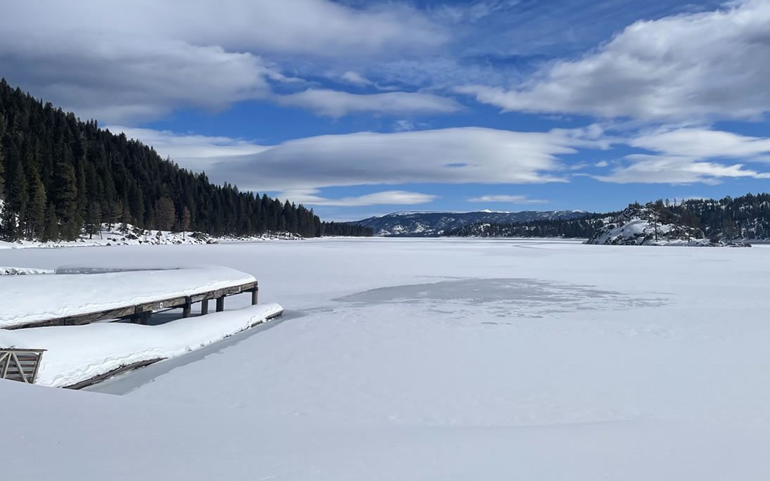
TAHOE’S EMERALD BAY FREEZES OVER FOR FIRST TIME IN DECADES
Tahoe’s Emerald Bay has completely frozen over for what is thought to be the first time in decades.Located just north of South Lake Tahoe, the last time the inlet froze over is believed to have been in the early 1990s, according to California State Park officials.
The below photos are from a little earlier in the month:

Tahoe’s Emerald Bay frozen over [California State Parks]

Tahoe’s Emerald Bay frozen over [California State Parks]
Emerald Bay sees partial freezes every winter, but for the bay to completely ice over is highly unusual, so say officials.
The ice is currently believed to be about 6 inches deep.
SKI SEASONS EXTENDED ACROSS U.S. THANKS TO HISTORIC SNOWPACK
Staying in Tahoe, Heavenly Mountain, Palisades Tahoe, Northstar, Kirkwood, and Sugar Bowl are among the many ski resorts that are extending their season.While most resorts usually close in early/mid-April, many are now staying open until May, some longer.
Palisades, for example, announced Thursday that they have received so much snow they’re staying open through July 4.
View: https://twitter.com/palisadestahoe/status/1638989075091980288
Run time is 0:21
Heavenly ski resort officials say a brutal winter has impacted this season’s operations.
“We opened Nov 11 and it’s been cold and snowy ever since. We haven’t seen a big melt or a lot of settlement. We’ve had four full closure days and then a number of wind hold days or visibility hold days just due to the amount of active weather we’ve seen this season,” said Ricky Newberry, Senior Director of Mountain Operations.
Heavenly expects to set a new snow record this year.
Traversing south, Mammoth Mountain announced it too is extending its ski season until at least the end of July after SoCal received historic totals this season, now just one snowstorm away from breaking its all-time record of 668 inches.
“Sitting on one of the deepest base depths ever recorded at Main Lodge, it’s going to be some of the best spring skiing and riding we’ve ever seen,” read a statement posted on Facebook:
(can't copy this over)
Shifting a little east, into Utah, it was way back in 1983 when the Beehive State’s snowpack was higher than it is now.
Thursday’s round of storms boosted Utah’s statewide snowpack to 25.7 inches, according to Natural Resources Conservation Service data, making it only the fourth time on record (beginning 1980) that the state has reached 25+ inches.
The other three occurrences were in 1982 (25.5 inches), 1983 (26 inches) and 1984 (25.2 inches).
Utah is now just 0.3 inches from that all-time record set 40 years ago now.
This reality chimes with what Prof. David Dilley recently postulated: “Weather is beginning to revert back to pre-1982 patterns around the world.”
Cars Entombed In Ice; Spring Blizzards Sweep Southern California; Crop-Wrecking Mid-March Snow Hits J&K, India; + Prof. David Dilley: "Winters Beginning to Revert Back to Pre-1982 Weather Patterns Around The World" - Electroverse
"Winters will become colder, longer lasting and more severe ... it's going to be very cold."
The National Weather Service’s Climate Prediction Center projections indicate a higher probability for more winter storm action to close out the month, meaning Utah’s all-time 1983 record (of 26 inches) is all but assured of falling.
While in Colorado, the state has endured an exceptional year for snowfall, with all regions, with the exception of the far southeast region, ahead of the 30-year snowpack average.
Persistent and disruptive winter weather has blown through seemingly non-stop this season, particularly across the southwest. And even now, with April fast approaching, areas were forecast 72 inches over a two-day period this week.
San Miguel-Dolores-Animas-San Juan river basin is pushing 180% of the snowpack norm.
And on March 23, the region surpassed the to-date all-time snowpack max of 29.9 inches set back in 1993.

USDA & NRCS snow water equivalent for the San Miguel-Dolores-Animas-San Juan basin
With a cold and snowy end to March on the cards, this season’s snowpack is likely to best the highest ever (1987’s 32.1 inches).

GFS 2m Temperature Anomalies (C) March 24 – 28 [tropicaltidbits.com].

GFS Total Snowfall (cm) March 24 – April 9 [tropicaltidbits.com].
Enjoy your weekend.
It’s still a little too cold for me to get my corn into the ground, so I’ll spend my days finishing the goat shed and pig sty.
Our new Kunekunes are ready to be collected next week. Self-sufficiency is key in the times we’re entering into. For those who want to not only survive by thrive, steps need to be taken everyday. Do something. It’s now spring — throw some seeds into the ground.
See you Monday.
Melodi
Disaster Cat
Although I still think we are overall in a Grand Solar Minimum period, the sun still manages to have a weak solar Maximum this year. I don't believe this is a bad thing, but it does suggest that humans have a lot ot learn yet about solar cycles and how they operate. They are not nearly as simple as was once thought. They can be regular for a century or two and then get wonky. I also wanted to share this magnificent picture taken last night. As far as I know, it is not photoshopped. It was just taken by a lucky photo bug last night at Stone Henge towards the end of the aurora display. I have seen similar ones from New Grange though we haven't seen any auroras here at the house because of bad weather. They are pretty far south this year. I also hosted this photo on the main CME thread. I expect it will be moved to this room in a day or two. This is from a friend's facebook page in the UK.

northern watch
TB Fanatic
I am waiting to see what May and June will bring, when warmer temperatures are expected.Although I still think we are overall in a Grand Solar Minimum period, the sun still manages to have a weak solar Maximum this year. I don't believe this is a bad thing, but it does suggest that humans have a lot ot learn yet about solar cycles and how they operate. They are not nearly as simple as was once thought. They can be regular for a century or two and then get wonky. I also wanted to share this magnificent picture taken last night. As far as I know, it is not photoshopped. It was just taken by a lucky photo bug last night at Stone Henge towards the end of the aurora display. I have seen similar ones from New Grange though we haven't seen any auroras here at the house because of bad weather. They are pretty far south this year. I also hosted this photo on the main CME thread. I expect it will be moved to this room in a day or two. This is from a friend's facebook page in the UK.
Southside
Has No Life - Lives on TB
Shows me getting lots of snow again.Polar Plunge To Grip Europe; Tahoe's Emerald Bay Freezes Over For First Time In Decades; + Ski Seasons Extended Across U.S. Thanks To Historic Snowpack - Electroverse
Emerald Bay sees partial freezes every winter, but for the bay to completely ice over is highly unusual, so say officials.electroverse.info
POLAR PLUNGE TO GRIP EUROPE; TAHOE’S EMERALD BAY FREEZES OVER FOR FIRST TIME IN DECADES; + SKI SEASONS EXTENDED ACROSS U.S. THANKS TO HISTORIC SNOWPACK
MARCH 24, 2023 CAP ALLON
POLAR PLUNGE TO GRIP EUROPE
Another avalanche death has been posted in the European Alps this week — an 18-year-old British man has been swept to his death in Switzerland, with another person still missing.
The tragedy occurred in the resort area of Meiringen following heavy snowfall.
Swiss Alpine Rescue and several helicopters were immediately deployed, and recovered the body of the British teenager. The search for the second skier is ongoing. Air rescue teams have joined the search, as have mountain specialists and local police.
A police spokeswoman said: “The avalanche was set off when two of the skiers went down. They were both buried. The emergency services, which were deployed immediately, could only recover a buried man who was dead.
“The search for the second person had to be interrupted. It was resumed in the morning of Wednesday. But the emergency search was then stopped around lunchtime. There have been no sightings of the skier or any ski equipment.
“The rescuers have done everything they were able to do. Resources have been exhausted. We have tried everything that we could. It is quite a big area to search. The avalanche was 800m long.”
Looking ahead, further rounds of heavy spring snow are on the cards for the Alps — as well as parts of the UK, practically all of Scandinavia, the Balkans, and a large band extending north-to-south over far-eastern Europe, including the Ukraine:

GFS Total Snowfall (cm) March 24 – April 9 [tropicaltidbits.com].
The heaviest snows will arrive in line with a late-March polar plunge, due to bring temperature anomalous of as much as -16C below the seasonal norm to Sweden and Norway, for example:

GFS 2m Temperature Anomalies (C) March 27 – 28 [tropicaltidbits.com].
While speculating further ahead, the British tabloids are getting excited about new long-term weather models that predict “a record cold Easter” this year, prompting bookmakers to slash their odds on Easter being the chillest ever.
This remains to be seen, and if you know the UK tabloid rhetoric, it usually proves complete and utter bollocks. But still, “weather warnings across the UK suggest we’re already well on course for a record-breaking cold Easter,” so says Alex Apati of Ladbrokes, and Met Office reports do show the vast majority of the country being hit by an extreme cold spell come April 9.
Temperatures as low was -8C (17.6F) are scheduled to hit the Scottish Highlands, once again — record lows for the time of year.
TAHOE’S EMERALD BAY FREEZES OVER FOR FIRST TIME IN DECADES
Tahoe’s Emerald Bay has completely frozen over for what is thought to be the first time in decades.
Located just north of South Lake Tahoe, the last time the inlet froze over is believed to have been in the early 1990s, according to California State Park officials.
The below photos are from a little earlier in the month:

Tahoe’s Emerald Bay frozen over [California State Parks]

Tahoe’s Emerald Bay frozen over [California State Parks]
Emerald Bay sees partial freezes every winter, but for the bay to completely ice over is highly unusual, so say officials.
The ice is currently believed to be about 6 inches deep.
SKI SEASONS EXTENDED ACROSS U.S. THANKS TO HISTORIC SNOWPACK
Staying in Tahoe, Heavenly Mountain, Palisades Tahoe, Northstar, Kirkwood, and Sugar Bowl are among the many ski resorts that are extending their season.
While most resorts usually close in early/mid-April, many are now staying open until May, some longer.
Palisades, for example, announced Thursday that they have received so much snow they’re staying open through July 4.
View: https://twitter.com/palisadestahoe/status/1638989075091980288
Run time is 0:21
Heavenly ski resort officials say a brutal winter has impacted this season’s operations.
“We opened Nov 11 and it’s been cold and snowy ever since. We haven’t seen a big melt or a lot of settlement. We’ve had four full closure days and then a number of wind hold days or visibility hold days just due to the amount of active weather we’ve seen this season,” said Ricky Newberry, Senior Director of Mountain Operations.
Heavenly expects to set a new snow record this year.
Traversing south, Mammoth Mountain announced it too is extending its ski season until at least the end of July after SoCal received historic totals this season, now just one snowstorm away from breaking its all-time record of 668 inches.
“Sitting on one of the deepest base depths ever recorded at Main Lodge, it’s going to be some of the best spring skiing and riding we’ve ever seen,” read a statement posted on Facebook:
(can't copy this over)
Shifting a little east, into Utah, it was way back in 1983 when the Beehive State’s snowpack was higher than it is now.
Thursday’s round of storms boosted Utah’s statewide snowpack to 25.7 inches, according to Natural Resources Conservation Service data, making it only the fourth time on record (beginning 1980) that the state has reached 25+ inches.
The other three occurrences were in 1982 (25.5 inches), 1983 (26 inches) and 1984 (25.2 inches).
Utah is now just 0.3 inches from that all-time record set 40 years ago now.
This reality chimes with what Prof. David Dilley recently postulated: “Weather is beginning to revert back to pre-1982 patterns around the world.”
Cars Entombed In Ice; Spring Blizzards Sweep Southern California; Crop-Wrecking Mid-March Snow Hits J&K, India; + Prof. David Dilley: "Winters Beginning to Revert Back to Pre-1982 Weather Patterns Around The World" - Electroverse
"Winters will become colder, longer lasting and more severe ... it's going to be very cold."
The National Weather Service’s Climate Prediction Center projections indicate a higher probability for more winter storm action to close out the month, meaning Utah’s all-time 1983 record (of 26 inches) is all but assured of falling.
While in Colorado, the state has endured an exceptional year for snowfall, with all regions, with the exception of the far southeast region, ahead of the 30-year snowpack average.
Persistent and disruptive winter weather has blown through seemingly non-stop this season, particularly across the southwest. And even now, with April fast approaching, areas were forecast 72 inches over a two-day period this week.
San Miguel-Dolores-Animas-San Juan river basin is pushing 180% of the snowpack norm.
And on March 23, the region surpassed the to-date all-time snowpack max of 29.9 inches set back in 1993.

USDA & NRCS snow water equivalent for the San Miguel-Dolores-Animas-San Juan basin
With a cold and snowy end to March on the cards, this season’s snowpack is likely to best the highest ever (1987’s 32.1 inches).

GFS 2m Temperature Anomalies (C) March 24 – 28 [tropicaltidbits.com].

GFS Total Snowfall (cm) March 24 – April 9 [tropicaltidbits.com].
Enjoy your weekend.
It’s still a little too cold for me to get my corn into the ground, so I’ll spend my days finishing the goat shed and pig sty.
Our new Kunekunes are ready to be collected next week. Self-sufficiency is key in the times we’re entering into. For those who want to not only survive by thrive, steps need to be taken everyday. Do something. It’s now spring — throw some seeds into the ground.
See you Monday.
Not going to happen.
northern watch
TB Fanatic

TxGal
Day by day
Fierce Spring Freeze Grips Siberia; Record March Cold Tears Across Scandinavia; -34F In Utah; + Latest Snowfall Ever For Yushan, Taiwan - Electroverse
Rug up. Grand Solar Minimum and Pole Shift incomming.

FIERCE SPRING FREEZE GRIPS SIBERIA; RECORD MARCH COLD TEARS ACROSS SCANDINAVIA; -34F IN UTAH; + LATEST SNOWFALL EVER FOR YUSHAN, TAIWAN
MARCH 27, 2023 CAP ALLONFIERCE SPRING FREEZE GRIPS SIBERIA
Much of transcontinental Russia has been holding very cold of late, particularly swathes of Siberia as well as the northwest.Over the weekend, a low of -48.4C (-55.1F) was registered in Delyankir, Siberia — a very rare reading in Russia for late March.
For reference, Oymyakon logged -49.6C (-57.3F) on March 28, 1998, with Verkhoyansk posting -50.1C (-58.2F) on March 29, 1942.
The spring chills have been pushing into NW Russia, too.
Here, -32.5C (26.5F) and -32C (25.6F) were registered in Yaniskoski and Lovozero, respectively.
RECORD MARCH COLD TEARS ACROSS SCANDINAVIA
The cold didn’t stop at the Russian border, of course, and extended westward across ALL of Scandinavia.A record -37.5C (-35.5F) has been posted Finland, with -36.8C (-34.2F) noted in Sweden — historically low readings for late March. In fact, for such low readings after the vernal equinox you have to go back more than a hundred years, to 1916 (the Centennial Minimum).
Record lows have swept ALL of Scandinavia, with the likes of Nikkaluokta, Naimakka, Pajala in Sweden all breaking long-standing benchmarks, with the latter, Pajala, never before observing such a low reading this late into the year (-33.7C/-28.7F).
Likewise in Finland, that low of 37.5C logged at Kittilä airport was 1) the coldest temperature of the entire winter season, besting Kevojärvi’s 35C from March 6, and 2) the latest-ever date for such a low–as confirmed by the Finnish weather service.
View: https://twitter.com/ThierryGooseBC/status/1639306808895602688
Looking ahead, additional cold is on the cards, with frosts proving problematic for growers from the Baltic to the Balkans:

GFS 2m Temperature Anomalies (C) April 5 [tropicaltidbits.com].
Accompanying the unseasonable cold will be heavy and widespread spring snow, particularly for the likes of NW Russia, Finland, Belarus, Poland, the Alps and Turkey; even the UK is forecast flurries, during the first half of April:

GFS Total Snowfall (cm) March 27 – April 12 [tropicaltidbits.com].
-34F IN UTAH
Record lows hit the North America over the weekend, adding to the hundreds that fell last week.
A moose-hugging -39.9C (-39.8F) was registered at Key Lake, Saskatchewan, Canada.
While in the U.S., the coldest spot was taken by Peter Sinks, Utah with Sunday’s low of -34F (-36.7C).

Staying in Utah, the record-breaking snowfall this winter has been truly phenomenal — no hyperbole.
The director of the Snow Hydrology Research to Operations Lab at the University of Utah said she could have never predicted that her equipment at the top of Little Cottonwood Canyon would ever be buried by snow — but here we are.
“The snow really has not stopped,” said McKenzie Skiles. “This winter we’ve just been getting storm after storm after storm.”
Run time is 2:33
And while the likes of Utah and California are stealing all the headlines, disruptive snow continues to impact many U.S. states.
In North Dakota, for example, persistent and record-setting snow is impacting statewide affairs, including even funerals.
At Eastgate Funeral Home in Bismarck, the snow has delayed burials in the cemeteries with the pack standing higher than the tombstones in some cases.
“What we are having issues with is because the depth of the snow even in town. There are some cemeteries that are going to say we have to find out where the grave is and determine if we can even do the burial at that time,” said Joe Braun, general manager and licensed funeral director at Eastgate and Parkway Funeral Service.
In hundreds of cases at Eastgate alone, burials are on hold until the warmer months arrive.
LATEST SNOWFALL EVER FOR YUSHAN, TAIWAN
On Sunday morning, Yushan, the highest mountain in Taiwan, set a national record for the latest-ever snowfall.Established some 80 years ago, Yushan weather station registered a low of -0.2C (31.6F) in the early hours of March 26, and captured unprecedented late-March snowfall from 7:05 AM, according to Chang, a Central Weather Bureau (CWB) forecaster.
Run time is 1:13
Further flurries were expected later on Sunday, so says Chang, who also points out that Yushan failed to see any snow at all this winter (Dec to Feb) –the mountain’s longest snowless streak– making Sunday’s flakes even more unexpected and remarkable.
Earth’s weather is being thrown out of whack by a number of natural forcings.
These include a waning magnetosphere and historically low solar activity — and their impacts on the jet stream.
Overall, though,
For more:
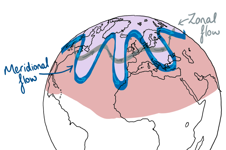
Explained: Low Solar Activity And A 'Meridional' Jet Stream Flow - Electroverse
Reject the politicized cries of “climate emergency!”, they are not rooted in science.

Magnetic Pole Shift + Low Solar Activity: "A Global Environmental Crisis" Has Begun - Electroverse
You might look at this as 'The true Great Reset'. Grand Solar Minimum plus Pole Shift. Prepare accordingly.
northern watch
TB Fanatic
From my email inbox The Old Farmer's Almanac March 27 2023

Two giant ‘holes’ appear on sun and could send 1.8 million-mph solar winds toward Earth Brendan Taylor March 29, 2023 2:03 pm
Insider Paper
News • Tech and Science
Two giant ‘holes’ appear on sun and could send 1.8 million-mph solar winds toward Earth
Brendan Taylor
March 29, 2023 2:03 pm
northern watch
TB Fanatic

northern watch
TB Fanatic

northern watch
TB Fanatic

northern watch
TB Fanatic

northern watch
TB Fanatic


northern watch
TB Fanatic

northern watch
TB Fanatic


northern watch
TB Fanatic
This is what I expect for a GSM