
You are using an out of date browser. It may not display this or other websites correctly.
You should upgrade or use an alternative browser.
You should upgrade or use an alternative browser.
Solar Grand Solar Minimum part deux
- Thread starter Dennis Olson
- Start date
-
- Tags
- grand solar minimum

northern watch
TB Fanatic

northern watch
TB Fanatic

northern watch
TB Fanatic

northern watch
TB Fanatic
From my email inbox The Old Farmer's Almanac November 18 2022

northern watch
TB Fanatic

northern watch
TB Fanatic
From my email inbox The Old Farmer's Almanac November 17 2022

jed turtle
a brother in the Lord
Yikes! I need another 4 weeks or so of no such “weather”... and I’m only a 5 hour drive East of Buffalo... need more fire wood, more outdoor projects finished...too late, too late... seems like the whole darned world has gone over the edge
Last edited:
northern watch
TB Fanatic


northern watch
TB Fanatic
From my email inbox The Old Farmer's Almanac November 20 2022

northern watch
TB Fanatic
From my email inbox The Old Farmer's Almanac November 21 2022

alpha
Veteran Member
Electroverse
 Extreme Weather
From Washington State to Florida, from Arizona to New York, hundreds of cold records are falling, just as those murderous, treacherous and antihuman psychopaths at COP27 agree to dirty ‘wealth redistribution’ packages whereby “rich” nations will compensate poor nations for the ravages of gLoBaL wArMiNg (to the tune of hundreds of billions of dollars).
Over the past 24-hours alone (0700 UTC Nov 20 to 0600 UTC Nov 21) hundreds of new low temperature have been set across the Lower 48, as collated by coolwx.com:

This reality flies in the face of The Narrative, of course; but then I remember my lamestream teachings: descending Arctic air is natural; influxes of tropical air, on the other hand, are anthropogenic, the result of the building block of life, carbon.
Grand Solar Minimum 101: The Future Looks Cold

The Sun is at its weakest state in more than a century, and the impacts on Earth’s weather/climate are unfolding before our eyes, whether we know it or not…
Accompanying the record-breaking cold has been truly historic accumulations of snow.
The inches are forecast to continue piling up across swathes of the U.S., too, particularly western New York state which will add to its record-slaying weekend accumulations which saw the Buffalo area log 6+ feet.
While Buffalo is used to crazy snow totals, this storm is delivering “much more than we usually get,” Mayor Byron Brown said Saturday, and it’s expanding over a large area, too, engulfing the likes of Cleveland and Dunkirk to the south.
Erie County experienced its largest-ever amount of snowfall in a 24-hour period (in any month) on Saturday.

County Executive Mark Poloncarz called it “a record-breaking storm that in some ways was more intense than Snowvember”–referring to the winter storm that struck the Buffalo area in November 2014 when 7 feet of snow accumulated in three days, killing 13 people.
So far, two people have known to have died in this storm, from cardiac complications (no comment) related to shoveling snow.

The heavy snow continued Sunday, with the heaviest dumpings noted east of Lake Ontario, where another 2 feet settled.

An observation site near Orchard Park, where the NFL’s Buffalo Bills play, recorded a snow total of 80 inches Thursday through Saturday, according to the NWS — the third-highest three-day total ever in the state of New York (in books dating back to the 1800s).
The multiday weather event has made travel in the region almost impossible, triggering the closing of roads, driving bans and flight cancellations the weekend before the Thanksgiving holiday.
Planes were grounded at Buffalo Niagara International Airport where a new daily snowfall record was set: the 21.5 inches that fell Saturday smashed the 7.6 inches from Nov 19, 2014, making it the airport’s third-snowiest November ever with a third of the month left to run.
Saturday’s snow also ranks as the fifth-highest single-day total in Buffalo history and the second-highest single-day accumulation for the month of November.

Records have been broken across the region, not just in Buffalo, of course.
Watertown, for example, had picked up 61 inches by early Sunday morning, which, once confirmed, will go down as the largest 2-day snowfall event in the city’s history, comfortably surpassing the previous record of 46.3 inches set Dec 9 and 10, 1995 (solar minimum of cycle 22).
Local media outlets are comparing this event to the Blizzard of 1977–a lake-effect storm that lasted four-days and delivered 66 inches to Watertown (during solar min of cycle 20); and while the ’77 Blizzard was far worse in terms of impacts, when simply comparing how much snow fell, this recent snowstorm will go down as the worst, once verified by the Climate Center, with the NWS hoping to have the snow totals added up and posted either Monday or Tuesday.

Buffalo residents shoveling historic accumulations of snow in front of their house.
Speaking at a storm briefing in Jefferson County on Sunday, New York Governor Kathy Hochul said the area in upstate Oswego County was on course for another 2 feet of snow by Sunday evening, at an astonishing rate of four inches per hour.
“This has been an historic storm, without a doubt, it’s one for the record books … This is one to tell your grandkids about,” said Hochul. “Given the scale of this storm I’m really proud of how the utility crews have stepped up.”
Nearly 6 million people across four Great Lakes states (that’s Michigan, Ohio, Pennsylvania, and New York) remained under winter weather alerts through Sunday, with many extending into the new week, too.
Eyeing the next two-or-so weeks, the snow totals look unrelenting and are forecast to extend as far south as Mexico:

GFS Total Snowfall (inches) Nov 21 – Dec 07 [tropicaltidbits.com].
All this snow will only add to the Finnish Meteorological Institute’s ‘Total snow mass for the Northern Hemisphere’ chart, which, as of the latest datapoint (Nov 18), shows that this season’s snow extent is continuing to track above the 1982-2012 average:

[FMI]
Refocusing on the U.S., following a week of unsettled and ‘topsy-turvy’ conditions, another full-blown Arctic outbreak is threatening to descend deep into the North American continent as of late-Nov/early-Dec.
Stay tuned for updates.
As we’re seeing in the U.S., descending Arctic air has gripped swathes of the continent –particularly Central and Eastern parts– with heavy snow noted in the higher regions–even over the Western mountains of Spain and Portugal:

Electroverse
@Electroversenet
First heavy snow of the season hits Portugal, ahead of schedule (a typical snow season runs Dec-April). #ClimateScam https://t.co/BVBZJUp93q
12:08 PM · Nov 18, 2022
Many European weather stations, notably those sited across German and Poland, and just registered their coldest November temperatures in decades, with lows of -13C (8.6F) sweeping even the lower elevations.
While in Northern nations, warnings are in place for not only plunging temperatures but heavy snowfall, too…
Snow Warnings For Sweden
Fresh snow warnings are in place across Scandinavia, including Sweden.
Swedish weather forecaster SMHI has expanded its orange warning to include the Stockholm area and Gotland.
“It applies to heavy snowfall from tonight (Sunday) to tomorrow evening,” said SMHI meteorologist Therese Fougman. “It is uncertain exactly which area most snow will end up but there will be large amounts.”
Saturday night had already delivered 21+ cm (8.3 inches) to the likes of Stockhom and Holmbo, with plenty more falling throughout Sunday and into Monday. Public transport organisation SL has advised travelers to work from home if possible.

Christian Lord
@Hellspawnlord
Stockholm Sweden been pouring down snow whole day https://t.co/ZaoFOAZrnT

5:10 PM · Nov 20, 2022
Along with the myriad of ‘orange’ snowfall warnings, ‘yellow’ warnings are in place in Öland, Kalmar county, Östergötland and Sörmland, as well as areas west of Lake Vättern.

Christy Bontrager
@ChristyBonUI
the snow came all at once #nacka #sweden https://t.co/KGaM83hhBI

5:00 AM · Nov 21, 2022
Europe’s freezing lows and heavy snows are forecast to intensify from here on out; conditions that will begin running down the continent’s energy reserves early with no clear/quick way to top them back up.
Cold India
The state of Telangana, India is in the grips of ‘cold wave conditions’ with many locales logging lows below 10C (50F).
The Indian Meteorological Department (IMD) has issued warnings for the likes of Adilabad, Kumuram Bheem Asifabad, Nirmal, Mancherial, Jagtiyal, Rajanna Sircilla, Medak and Sangareddy districts with the anomalous cold (4C-8C below the norm) set to linger.
The IMD has attributed the drop in mercury to cold winds blowing from North and Northeast India — ‘natural’ causes, of course.
U.S. Breaks Hundreds Of Low Temperature Records, Snow Benchmarks Also Toppled; Central Europe Logs Lowest November Temps In Decades; Snow Warnings Issued In Sweden; + Cold India
November 21, 2022 Cap AllonU.S. Breaks Hundreds Of Low Temperature Records…
The descending mass of Arctic air continues to fell low temperature records across the United States.From Washington State to Florida, from Arizona to New York, hundreds of cold records are falling, just as those murderous, treacherous and antihuman psychopaths at COP27 agree to dirty ‘wealth redistribution’ packages whereby “rich” nations will compensate poor nations for the ravages of gLoBaL wArMiNg (to the tune of hundreds of billions of dollars).
Over the past 24-hours alone (0700 UTC Nov 20 to 0600 UTC Nov 21) hundreds of new low temperature have been set across the Lower 48, as collated by coolwx.com:

This reality flies in the face of The Narrative, of course; but then I remember my lamestream teachings: descending Arctic air is natural; influxes of tropical air, on the other hand, are anthropogenic, the result of the building block of life, carbon.
Grand Solar Minimum 101: The Future Looks Cold
The Sun is at its weakest state in more than a century, and the impacts on Earth’s weather/climate are unfolding before our eyes, whether we know it or not…
…Snow Benchmarks Also Toppled
Accompanying the record-breaking cold has been truly historic accumulations of snow.The inches are forecast to continue piling up across swathes of the U.S., too, particularly western New York state which will add to its record-slaying weekend accumulations which saw the Buffalo area log 6+ feet.
While Buffalo is used to crazy snow totals, this storm is delivering “much more than we usually get,” Mayor Byron Brown said Saturday, and it’s expanding over a large area, too, engulfing the likes of Cleveland and Dunkirk to the south.
Erie County experienced its largest-ever amount of snowfall in a 24-hour period (in any month) on Saturday.

County Executive Mark Poloncarz called it “a record-breaking storm that in some ways was more intense than Snowvember”–referring to the winter storm that struck the Buffalo area in November 2014 when 7 feet of snow accumulated in three days, killing 13 people.
So far, two people have known to have died in this storm, from cardiac complications (no comment) related to shoveling snow.

The heavy snow continued Sunday, with the heaviest dumpings noted east of Lake Ontario, where another 2 feet settled.

An observation site near Orchard Park, where the NFL’s Buffalo Bills play, recorded a snow total of 80 inches Thursday through Saturday, according to the NWS — the third-highest three-day total ever in the state of New York (in books dating back to the 1800s).
The multiday weather event has made travel in the region almost impossible, triggering the closing of roads, driving bans and flight cancellations the weekend before the Thanksgiving holiday.
Planes were grounded at Buffalo Niagara International Airport where a new daily snowfall record was set: the 21.5 inches that fell Saturday smashed the 7.6 inches from Nov 19, 2014, making it the airport’s third-snowiest November ever with a third of the month left to run.
Saturday’s snow also ranks as the fifth-highest single-day total in Buffalo history and the second-highest single-day accumulation for the month of November.

Records have been broken across the region, not just in Buffalo, of course.
Watertown, for example, had picked up 61 inches by early Sunday morning, which, once confirmed, will go down as the largest 2-day snowfall event in the city’s history, comfortably surpassing the previous record of 46.3 inches set Dec 9 and 10, 1995 (solar minimum of cycle 22).
Local media outlets are comparing this event to the Blizzard of 1977–a lake-effect storm that lasted four-days and delivered 66 inches to Watertown (during solar min of cycle 20); and while the ’77 Blizzard was far worse in terms of impacts, when simply comparing how much snow fell, this recent snowstorm will go down as the worst, once verified by the Climate Center, with the NWS hoping to have the snow totals added up and posted either Monday or Tuesday.

Buffalo residents shoveling historic accumulations of snow in front of their house.
Speaking at a storm briefing in Jefferson County on Sunday, New York Governor Kathy Hochul said the area in upstate Oswego County was on course for another 2 feet of snow by Sunday evening, at an astonishing rate of four inches per hour.
“This has been an historic storm, without a doubt, it’s one for the record books … This is one to tell your grandkids about,” said Hochul. “Given the scale of this storm I’m really proud of how the utility crews have stepped up.”
Nearly 6 million people across four Great Lakes states (that’s Michigan, Ohio, Pennsylvania, and New York) remained under winter weather alerts through Sunday, with many extending into the new week, too.
Eyeing the next two-or-so weeks, the snow totals look unrelenting and are forecast to extend as far south as Mexico:

GFS Total Snowfall (inches) Nov 21 – Dec 07 [tropicaltidbits.com].
All this snow will only add to the Finnish Meteorological Institute’s ‘Total snow mass for the Northern Hemisphere’ chart, which, as of the latest datapoint (Nov 18), shows that this season’s snow extent is continuing to track above the 1982-2012 average:
[FMI]
Refocusing on the U.S., following a week of unsettled and ‘topsy-turvy’ conditions, another full-blown Arctic outbreak is threatening to descend deep into the North American continent as of late-Nov/early-Dec.
Stay tuned for updates.
Central Europe Logs Lowest November Temps In Decades
Europe’s mild autumn has just turned decidedly chillier — record-breakingly so, in fact.As we’re seeing in the U.S., descending Arctic air has gripped swathes of the continent –particularly Central and Eastern parts– with heavy snow noted in the higher regions–even over the Western mountains of Spain and Portugal:
Electroverse
@Electroversenet
First heavy snow of the season hits Portugal, ahead of schedule (a typical snow season runs Dec-April). #ClimateScam https://t.co/BVBZJUp93q
12:08 PM · Nov 18, 2022
Many European weather stations, notably those sited across German and Poland, and just registered their coldest November temperatures in decades, with lows of -13C (8.6F) sweeping even the lower elevations.
While in Northern nations, warnings are in place for not only plunging temperatures but heavy snowfall, too…
Snow Warnings For Sweden
Fresh snow warnings are in place across Scandinavia, including Sweden.
Swedish weather forecaster SMHI has expanded its orange warning to include the Stockholm area and Gotland.
“It applies to heavy snowfall from tonight (Sunday) to tomorrow evening,” said SMHI meteorologist Therese Fougman. “It is uncertain exactly which area most snow will end up but there will be large amounts.”
Saturday night had already delivered 21+ cm (8.3 inches) to the likes of Stockhom and Holmbo, with plenty more falling throughout Sunday and into Monday. Public transport organisation SL has advised travelers to work from home if possible.
Christian Lord
@Hellspawnlord
Stockholm Sweden been pouring down snow whole day https://t.co/ZaoFOAZrnT
5:10 PM · Nov 20, 2022
Along with the myriad of ‘orange’ snowfall warnings, ‘yellow’ warnings are in place in Öland, Kalmar county, Östergötland and Sörmland, as well as areas west of Lake Vättern.
Christy Bontrager
@ChristyBonUI
the snow came all at once #nacka #sweden https://t.co/KGaM83hhBI
5:00 AM · Nov 21, 2022
Europe’s freezing lows and heavy snows are forecast to intensify from here on out; conditions that will begin running down the continent’s energy reserves early with no clear/quick way to top them back up.
Cold India
The state of Telangana, India is in the grips of ‘cold wave conditions’ with many locales logging lows below 10C (50F).
The Indian Meteorological Department (IMD) has issued warnings for the likes of Adilabad, Kumuram Bheem Asifabad, Nirmal, Mancherial, Jagtiyal, Rajanna Sircilla, Medak and Sangareddy districts with the anomalous cold (4C-8C below the norm) set to linger.
The IMD has attributed the drop in mercury to cold winds blowing from North and Northeast India — ‘natural’ causes, of course.
northern watch
TB Fanatic

alpha
Veteran Member
Electroverse

Extreme Weather
According to the area’s weather books, which date back to 1898, last Friday’s trace was the earliest date for snow on record, besting the previous benchmark set 92 years ago on Nov 19, 1930.
For reference, the most snow ever recorded in DFW was logged during Feb, 2010, when 11 feet and 20 inches accumulated, totals that essentially closed down North Texas.
As predicted by the Farmer’s Almanac, this winter in North Texas will be another colder-than-normal one, with above-average snowfall expected.
A federal disaster has been declared for the north country and western New York after the historic lake effect snowstorm.
Federal aid is arriving in the region which will help state and local authorities clean up from the massive storm that dumped more than 6-feet of mid-November snow to the region. The emergency declaration authorizes the Department of Homeland Security and the Federal Emergency Management Agency to coordinate disaster relief in 11 counties buried by the unprecendetd snow.
The National Weather Service logged record-slaying totals in a host of locales, including Natural Bridge in Lewis County, which received 72 inches, and also Watertown’s 61 inches, which became the city’s largest snowfall event ever — to name just two.
Above the border, too, well-over a meter (3.3 ft) of snow blanketed parts of the Bruce Peninsula, Ontario, with 53 cm (1.74 ft) settling in Wiarton on Sunday alone — an accumulation that broke the area’s all-time single-day snow from 1982.
“I think it’s these earlier season lake-effect events that could see some signature from climate change going forward,” spouted an Environment Canada meteorologist on Monday, no doubt clamoring for answers that will meet the approval of his employer’s AGW Party backers…
Hot on the heels of slain cold records, the warm-mongering AGW Party have –predictably– issued a slew of ‘damage limitation’ stories: record-setting Arctic air and historic snowfall is caused by a “warming climate”, it turns out…
Many of the Northeast’s heaviest snowfalls have occurred since 1990, which, according to those bought-out hacks at scientificamerican.com, begs the question, how can the spate of big snowstorms be reconciled with our warming climate?
They use the old ‘warmer air can hold more moisture than cold air’ excuse, which, although of course true, would, in a genuinely warming climate, and particularly in mid-November, see precipitation fall as rain, not 6+ feet of record-slaying snow.
The early blast of descending polar cold is ignored by these activist-scientists; instead, the historic snow magicked its way out of the comparatively warm waters within the Great Lakes, and the accompanying record low temps are… well… erm… shut up…
What is crow-barred in, however, is the reassertion that our supposedly warming waters are also increasing the intensity of hurricanes. But here too, and as discussed in the article linked below, real world observations reveal that global hurricanes, overall, have no trend, and that Category 5 storms are actually declining:
Scientific America uses the below table as evidence that intensifying NE snowstorms are tied to rising global temperatures.

Ignoring the two cherry-picked locations (why not look at the entire NE region as a whole?), there are many potential forcings that could explain the intensifying snowstorms — ‘global warming’ I would put near the bottom, if not dead last. In fact, it likely wouldn’t even make my list, because it isn’t just one-off NE snowstorms that are shown to be increasing, it’s overall global snow cover.
The AGW Party do accept that one-off snowstorms are becoming stronger but only in a limited number of locations were temps already regularly fall below freezing–such as the Northeast; the overall trend, so their hypothesis goes, is of a less snowy planet.
However, since 2016, Northern Hemisphere snow mass seasons have been holding well-above the 1982-2012 average, and the 2022-2022 season is proving no different — as of the latest datapoint (Nov 19), the ‘Total snow mass for the NH’ chart, which comes courtesy of the Finnish Meteorological Institute (FMI), continues to ride above both the multidecadal average and the standard deviation (the chart also excludes the mountains –where it’s colder– further refuting the AGW Party assertion):

This isn’t a case of ‘warmer waters = increased global snow cover’, this would be illogical–and this isn’t what the AGW Party are claiming, either; as always, they are trying to have their cake and eat it, too, insisting, even in face of contradictory data (such as that embedded above), that global snow is in actual-fact decreasing: ‘NE snowstorms are increasing, but overall global snowpack is decreasing’ — this is the claim, but this is dead wrong, and this incompatibility threatens their entire narrative–and they know it.
Additional inconvenient observations are provided by Greenland: ‘the poster boy for global warming’.
This year, the Greenland Ice Sheet has opened the cold season in record-breaking fashion. This is, in books dating back to 1982, the strongest start to a snow/ice season ever–as visualized by the Danish Meteorological Institute’s Surface Mass Balance (SMB) charts below (blue line, bottom chart):

[DMI]
However, despite this reality, the agenda-driving legacy media continues to spoon-feed the indoctrinated masses Grimms’ Fairy Tales of terrifying glacial melt and disastrous sea level rise. But again, these stories are dead wrong and so threatens to unravel the yarns spun by AGW Party over the past few decades.
The official global temperature record is another obfuscating ruse. This dataset –that the likes of Scientific America base every other determination on– has been completely skewed by the Urban Heat Island (UHI) effect.
NASA/NOAA have admitted that they have to ‘guess’ the temperature for most parts of the world, due to poor station coverage. And they choose to base these estimations not on the rural temperature data, which is cooler, but rather on the closest metropolitan stations which, 1) can often be located hundreds of miles away, and 2) have been proven –and are widely accepted– hold much warmer than their rural counterparts.
This, to my mind, could explain ‘catastrophic global warming’ in its entirety, at least in recent years; that is, ever-expanding urban development and the insistence of government funded climate agencies to favor the warmer metropolitan stations over their cooler more remote cousins.
Moreover, if we look only at the satellite data, Earth’s temperature has been dropping since 2016, and continues to drop.
This reality, as well as those increasingly intense snowstorms and expanding global snow mass, can be far better explained by decreasing solar activity–namely via its weakening of the jet streams, which reverts the streams’ usual straight ‘zonal’ flow to more of a wavy ‘meridional’ one:

Summer Frosts In The Highlands Of Portugal & Spain, As Record Heat Sweeps Italy: Low Solar Activity & A ‘Meridional’ Jet Stream, Explained
The AGW hypothesis can confidently explain Central Europe’s heatwave; but it fails when it comes to Western Europe’s simultaneous summer freeze. A new theory is needed: ‘low solar activity’.
Looking again at that Boston and NY snow table, the 1978 snowstorms, the one in 1888, those in 1996 and 1997, and all storms post 2006-or-so can be tied to deceases in the Sun’s output.
You cannot link the intense snowstorms of the 1970s –which remain among the strongest in recorded history– to a heating planet/warming waters. Earth was cooling back then, the jet streams were ‘meridional’, and the pop-scientists of the day were warning of a fast-approaching Ice Age and pleading with world governments to prepare:

In fact, NOAA went so far as to blame “fossil fuel burning” for the cooling, saying that the resulting injection of particulates into the atmosphere “could screen out so much sunlight that the average temperature could drop by six degrees”:

Earth’s climate is as complex-a-system as we humans are ever likely to encounter — no way is ‘The Science’ settled.
To that point, we must reject the dire projections made by today’s mainstream pop-scientists, particularly the ‘solutions’ offered by unelected globalist bodies such as the UN and the WEF, those poverty-inducing ‘fixes’ that are then promoted by their bought-out MSM lapdogs — because as we’ve just seen, time routinely proves these types spectacularly and, often, dangerously wrong.
Furthermore, and lastly, the rare triple-dip La Nina we’re now enduring –a naturally occurring phenomenon tied to ocean cooling in the Pacific– has completely upended one major aspect of the AGW narrative.
A new study exposes this ‘issue’, which I’ll look into tomorrow.
Extreme Weather
Dallas-Fort Worth Sees Earliest-Ever Snowfall; + Federal Disaster Declared After Unprecedented Lake-Effect Snow–Which MSM Claims Is Due To A “Warming Climate”
November 22, 2022 Cap AllonDallas-Fort Worth Sees Earliest-Ever Snowfall
On November 18, Dallas-Fort Worth International Airport received its earliest snowfall in recorded history.According to the area’s weather books, which date back to 1898, last Friday’s trace was the earliest date for snow on record, besting the previous benchmark set 92 years ago on Nov 19, 1930.
For reference, the most snow ever recorded in DFW was logged during Feb, 2010, when 11 feet and 20 inches accumulated, totals that essentially closed down North Texas.
As predicted by the Farmer’s Almanac, this winter in North Texas will be another colder-than-normal one, with above-average snowfall expected.
Federal Disaster Declared After Unprecedented Lake-Effect Snow…
A federal disaster has been declared for the north country and western New York after the historic lake effect snowstorm.Federal aid is arriving in the region which will help state and local authorities clean up from the massive storm that dumped more than 6-feet of mid-November snow to the region. The emergency declaration authorizes the Department of Homeland Security and the Federal Emergency Management Agency to coordinate disaster relief in 11 counties buried by the unprecendetd snow.
The National Weather Service logged record-slaying totals in a host of locales, including Natural Bridge in Lewis County, which received 72 inches, and also Watertown’s 61 inches, which became the city’s largest snowfall event ever — to name just two.
Above the border, too, well-over a meter (3.3 ft) of snow blanketed parts of the Bruce Peninsula, Ontario, with 53 cm (1.74 ft) settling in Wiarton on Sunday alone — an accumulation that broke the area’s all-time single-day snow from 1982.
“I think it’s these earlier season lake-effect events that could see some signature from climate change going forward,” spouted an Environment Canada meteorologist on Monday, no doubt clamoring for answers that will meet the approval of his employer’s AGW Party backers…
…Which MSM Claims Is Due To A “Warming Climate”
Hot on the heels of slain cold records, the warm-mongering AGW Party have –predictably– issued a slew of ‘damage limitation’ stories: record-setting Arctic air and historic snowfall is caused by a “warming climate”, it turns out…Many of the Northeast’s heaviest snowfalls have occurred since 1990, which, according to those bought-out hacks at scientificamerican.com, begs the question, how can the spate of big snowstorms be reconciled with our warming climate?
They use the old ‘warmer air can hold more moisture than cold air’ excuse, which, although of course true, would, in a genuinely warming climate, and particularly in mid-November, see precipitation fall as rain, not 6+ feet of record-slaying snow.
The early blast of descending polar cold is ignored by these activist-scientists; instead, the historic snow magicked its way out of the comparatively warm waters within the Great Lakes, and the accompanying record low temps are… well… erm… shut up…
What is crow-barred in, however, is the reassertion that our supposedly warming waters are also increasing the intensity of hurricanes. But here too, and as discussed in the article linked below, real world observations reveal that global hurricanes, overall, have no trend, and that Category 5 storms are actually declining:
Scientific America uses the below table as evidence that intensifying NE snowstorms are tied to rising global temperatures.

Ignoring the two cherry-picked locations (why not look at the entire NE region as a whole?), there are many potential forcings that could explain the intensifying snowstorms — ‘global warming’ I would put near the bottom, if not dead last. In fact, it likely wouldn’t even make my list, because it isn’t just one-off NE snowstorms that are shown to be increasing, it’s overall global snow cover.
The AGW Party do accept that one-off snowstorms are becoming stronger but only in a limited number of locations were temps already regularly fall below freezing–such as the Northeast; the overall trend, so their hypothesis goes, is of a less snowy planet.
However, since 2016, Northern Hemisphere snow mass seasons have been holding well-above the 1982-2012 average, and the 2022-2022 season is proving no different — as of the latest datapoint (Nov 19), the ‘Total snow mass for the NH’ chart, which comes courtesy of the Finnish Meteorological Institute (FMI), continues to ride above both the multidecadal average and the standard deviation (the chart also excludes the mountains –where it’s colder– further refuting the AGW Party assertion):
This isn’t a case of ‘warmer waters = increased global snow cover’, this would be illogical–and this isn’t what the AGW Party are claiming, either; as always, they are trying to have their cake and eat it, too, insisting, even in face of contradictory data (such as that embedded above), that global snow is in actual-fact decreasing: ‘NE snowstorms are increasing, but overall global snowpack is decreasing’ — this is the claim, but this is dead wrong, and this incompatibility threatens their entire narrative–and they know it.
Additional inconvenient observations are provided by Greenland: ‘the poster boy for global warming’.
This year, the Greenland Ice Sheet has opened the cold season in record-breaking fashion. This is, in books dating back to 1982, the strongest start to a snow/ice season ever–as visualized by the Danish Meteorological Institute’s Surface Mass Balance (SMB) charts below (blue line, bottom chart):

[DMI]
However, despite this reality, the agenda-driving legacy media continues to spoon-feed the indoctrinated masses Grimms’ Fairy Tales of terrifying glacial melt and disastrous sea level rise. But again, these stories are dead wrong and so threatens to unravel the yarns spun by AGW Party over the past few decades.
The official global temperature record is another obfuscating ruse. This dataset –that the likes of Scientific America base every other determination on– has been completely skewed by the Urban Heat Island (UHI) effect.
NASA/NOAA have admitted that they have to ‘guess’ the temperature for most parts of the world, due to poor station coverage. And they choose to base these estimations not on the rural temperature data, which is cooler, but rather on the closest metropolitan stations which, 1) can often be located hundreds of miles away, and 2) have been proven –and are widely accepted– hold much warmer than their rural counterparts.
This, to my mind, could explain ‘catastrophic global warming’ in its entirety, at least in recent years; that is, ever-expanding urban development and the insistence of government funded climate agencies to favor the warmer metropolitan stations over their cooler more remote cousins.
Moreover, if we look only at the satellite data, Earth’s temperature has been dropping since 2016, and continues to drop.
This reality, as well as those increasingly intense snowstorms and expanding global snow mass, can be far better explained by decreasing solar activity–namely via its weakening of the jet streams, which reverts the streams’ usual straight ‘zonal’ flow to more of a wavy ‘meridional’ one:
Summer Frosts In The Highlands Of Portugal & Spain, As Record Heat Sweeps Italy: Low Solar Activity & A ‘Meridional’ Jet Stream, Explained
The AGW hypothesis can confidently explain Central Europe’s heatwave; but it fails when it comes to Western Europe’s simultaneous summer freeze. A new theory is needed: ‘low solar activity’.
Looking again at that Boston and NY snow table, the 1978 snowstorms, the one in 1888, those in 1996 and 1997, and all storms post 2006-or-so can be tied to deceases in the Sun’s output.
You cannot link the intense snowstorms of the 1970s –which remain among the strongest in recorded history– to a heating planet/warming waters. Earth was cooling back then, the jet streams were ‘meridional’, and the pop-scientists of the day were warning of a fast-approaching Ice Age and pleading with world governments to prepare:

In fact, NOAA went so far as to blame “fossil fuel burning” for the cooling, saying that the resulting injection of particulates into the atmosphere “could screen out so much sunlight that the average temperature could drop by six degrees”:

Earth’s climate is as complex-a-system as we humans are ever likely to encounter — no way is ‘The Science’ settled.
To that point, we must reject the dire projections made by today’s mainstream pop-scientists, particularly the ‘solutions’ offered by unelected globalist bodies such as the UN and the WEF, those poverty-inducing ‘fixes’ that are then promoted by their bought-out MSM lapdogs — because as we’ve just seen, time routinely proves these types spectacularly and, often, dangerously wrong.
Furthermore, and lastly, the rare triple-dip La Nina we’re now enduring –a naturally occurring phenomenon tied to ocean cooling in the Pacific– has completely upended one major aspect of the AGW narrative.
A new study exposes this ‘issue’, which I’ll look into tomorrow.
") I need to find the articles again about shifting weather patterns on other planets (if it hasn’t already been discussed)).
I need to find the articles again about shifting weather patterns on other planets (if it hasn’t already been discussed)).northern watch
TB Fanatic

northern watch
TB Fanatic
Europe's First Major Cold Snap Of The Season Is Imminent
BY TYLER DURDENZERO HEDGE
TUESDAY, NOV 22, 2022 - 05:45 AM
Europe has had the luxury this fall of warmer-than-average temperatures, but that could all be changing as cold weather begins to pour into the energy-stricken continent.
Short to medium-range outlooks from forecaster Maxar Technologies LLC indicates a cold snap for Europe early this week -- average temperatures will rebound in the second half of the week, but frigid weather will return by early December.
Average temperatures across Central Europe were around freezing to start the week. By the end of the week, average temperatures will rise to a 30-year trendline of about 36 degrees Fahrenheit but then start heading lower into early December.
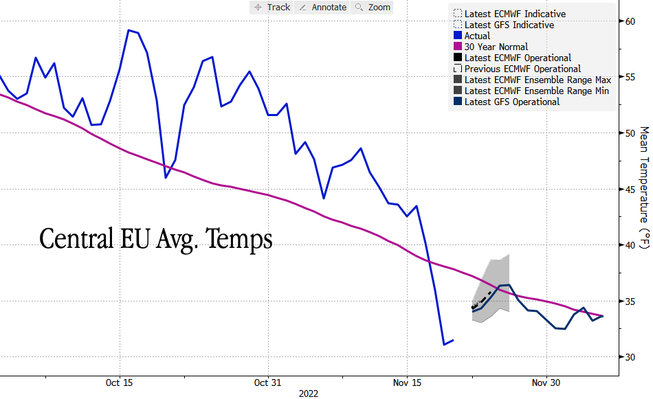
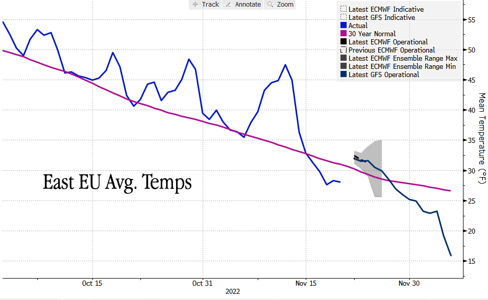
For East Europe, a significant cold snap is shaping up for early December. Temperatures are expected to average 15 degrees Fahrenheit by Dec 6 versus an average of around 25 degrees.
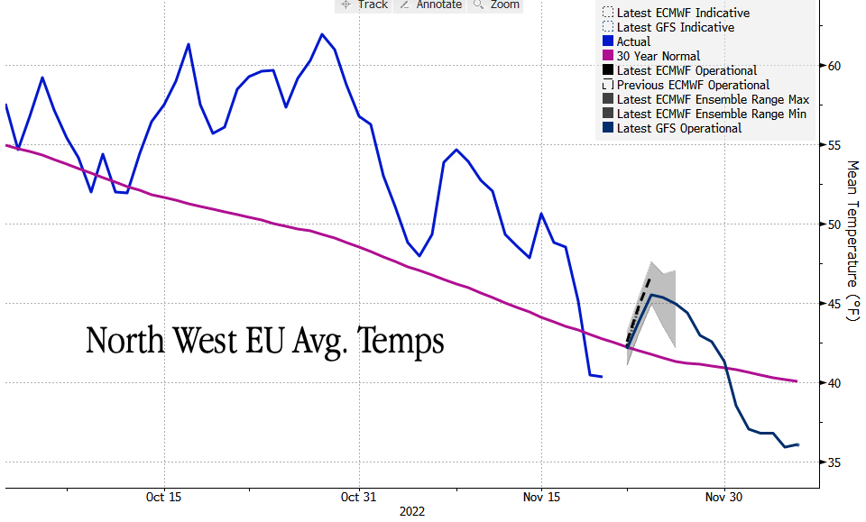
A similar drop in average temperatures is expected early next month for Nort West Europe.
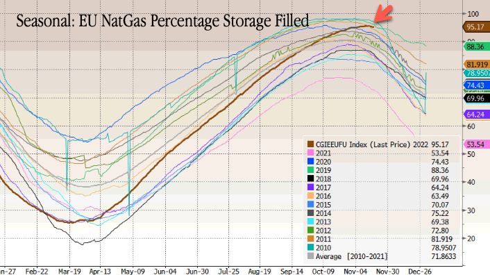
The good news is that EU countries have reached a Nov 1 target to fill natural gas storage sites by 80%. As of Monday, current levels stand at 95% due to unseasonably warm weather squashing heating demand, along with a push by EU countries to curb demand through conservation measures.
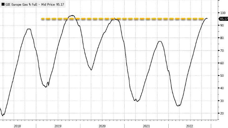
On a seasonal basis, EU NatGas levels are well above a 12-year mean, though the drawing period has begun.
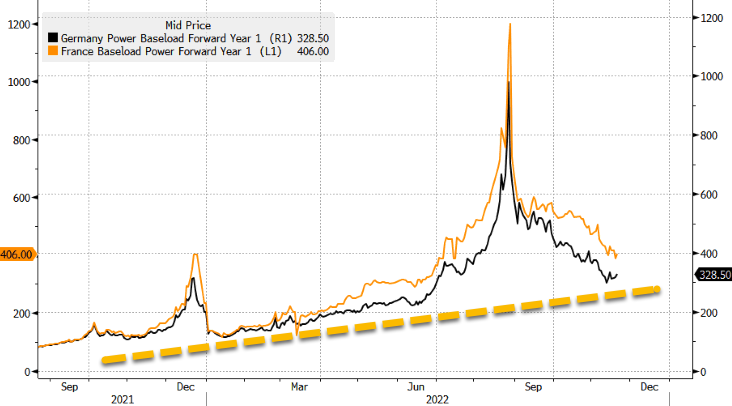
Bloomberg noted the new weather forecasts boosted power contracts for December for France and Germany, up more than 16% and 13%, respectively, on Monday. After months of decline, power prices in both countries could be set for an incline as cold weather sets in.
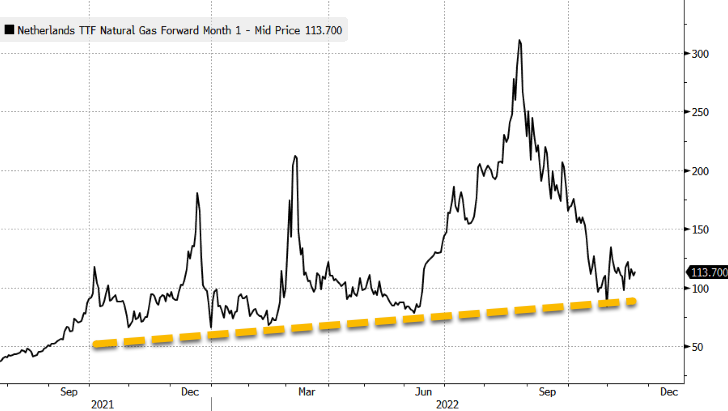
EU NatGas prices were slightly higher and have shown signs of a potential bottom after plunging by more than 63% since the August high.
Carlo Buontempo, director of the Copernicus Climate Change Service at the European Centre for Mid-Range Weather Forecasts (ECMWF), told Politico in mid-October that the probability was rising of a cold spell this year -- most likely in December -- remains "very real."
Some on Twitter are pointing out that winter is just ahead.
"By Dec 6, Europe is submerged in deep cold air down to Spain and North Africa. Something we have not seen in decades," one Twitter user said.
Another user said winter and recession could be a toxic combination for the continent.
However, someone else said the cold spell is not that unusual for this time of year.
The new forecasts are a bullish development for EU NatGas prices as heating demand ramps up.
Zerohedge
ZeroHedge - On a long enough timeline, the survival rate for everyone drops to zero
 www.zerohedge.com
Last edited:
alpha
Veteran Member
Electroverse

Articles
Earth’s climate system is unfathomably complex. Only a small percentage of the variables have been factored into the UN-funded models. A machine is only as good as the person that built it.
A new research paper has found ‘real world’ temperature differences in the Eastern Pacific Ocean that vary wildly from what the climate models say should be happening.
The study also suggests that La Niñas –the colder counterpart of El Niños– could keep on coming, adding to the climatic woes that the phenomenon delivers, which is to say harsher winters for much of the Northern Hemisphere, and heavy precipitation for the likes of Australia.
The global warming hypothesis favors El Niños, it always has.
The models decreed that El Niño’s would be the dominate ENSO pattern moving forward, correlating with rising global temperatures; the cold, deep ocean waters off South America were expected to rise to the surface, meet milder air and heat faster than the warmer ocean off Asia; this, in turn, would then decrease the temperature difference across the tropical Pacific and lighten the surface winds blowing toward Indonesia — aka, a El Niño setup.
Historical climate records confirm that during prior warm spells, Earth’s climate was more El Niño-like.
In recent years, however, La Niñas have been the dominant setup. In fact, the Northern Hemisphere is about to endure its third consecutive La Niña winter, something that has only occurred four times since 1900, and only twice since 1950.
So what’s going on? Is Earth now cooling?
The recent study, ‘Systematic Climate Model Biases in the Large-Scale Patterns of Recent Sea-Surface Temperature and Sea-Level Pressure Change’, looked at temperatures at the surface of the ocean recorded by ships and buoys from 1979 to 2020.
It was discovered that the Pacific Ocean off South America had actually cooled over that time, along with ocean regions farther south, too. This cannot be explained by the climate models. To put it delicately, big pieces of the puzzle are missing.
The upshot of this ‘unexpected’ reality is that the temperature difference between the eastern and western Pacific has grown, instead of shrunk as was prophesied; the surface winds blowing toward Indonesia have strengthened, not weakened; and residents of the NH are enduring their third consecutive La Niña winter, instead of its warmer counterpart, El Niño.
The climate models –that our ‘betters’ base their world-reshaping policy decisions on– have gotten it entirely backwards.
The researchers openly admit that they don’t know why this pattern is happening. Lead author Robert Wills, a UW research scientist in atmospheric sciences, said his team are now exploring possible links to the Antarctic ocean, which is also cooling.
“There’s something about the regional variation, the spatial pattern of warming in the tropical oceans, that is off,” said Wills, of the models. “If it turns out to be natural long-term cycles, maybe we can expect it to switch in the next five to ten years, but if it is a long-term trend due to some processes that are not well represented in the climate models, then it would be longer. Some mechanisms have a switch that would happen over the next few decades, but others could be a century or longer,” he added.
Let that sink in…
Also note that the study only ran to 2020, so didn’t have the data for the two most-recent La Nina winters where a further intensification of the cooling has been noted.
Honest climate scientists admit that there are serious issues with the models, the biggest being ‘clouds’ — they simply haven’t properly accounted for them/don’t understand them.
“All models are wrong, but some models are useful,” so the quote goes. Well, thus far, climate models are seemingly only useful for pushing warped, antihuman, globalist agendas — they have provenly failed in every other regard.
Another Climate Scientist with Impeccable Credentials Breaks Ranks: “Our models are Mickey-Mouse Mockeries of the Real World”September 3, 2022In "Articles"
Low Temp Record Set In Half Moon Bay, CA; Triple-Dip La Niña Winter Inbound (Like 1976?); + Texas Grid Found “Not Ready” For Winter, Doomed To Repeat Deadly 2021 Blackouts…October 28, 2022In "Extreme Weather"
Articles
New Study: Climate Models Got It Wrong, Eastern Pacific Ocean Is Cooling, La Niña Winters Could Keep On Coming
November 23, 2022 Cap AllonEarth’s climate system is unfathomably complex. Only a small percentage of the variables have been factored into the UN-funded models. A machine is only as good as the person that built it.
A new research paper has found ‘real world’ temperature differences in the Eastern Pacific Ocean that vary wildly from what the climate models say should be happening.
The study also suggests that La Niñas –the colder counterpart of El Niños– could keep on coming, adding to the climatic woes that the phenomenon delivers, which is to say harsher winters for much of the Northern Hemisphere, and heavy precipitation for the likes of Australia.
The global warming hypothesis favors El Niños, it always has.
The models decreed that El Niño’s would be the dominate ENSO pattern moving forward, correlating with rising global temperatures; the cold, deep ocean waters off South America were expected to rise to the surface, meet milder air and heat faster than the warmer ocean off Asia; this, in turn, would then decrease the temperature difference across the tropical Pacific and lighten the surface winds blowing toward Indonesia — aka, a El Niño setup.
Historical climate records confirm that during prior warm spells, Earth’s climate was more El Niño-like.
In recent years, however, La Niñas have been the dominant setup. In fact, the Northern Hemisphere is about to endure its third consecutive La Niña winter, something that has only occurred four times since 1900, and only twice since 1950.
So what’s going on? Is Earth now cooling?
The recent study, ‘Systematic Climate Model Biases in the Large-Scale Patterns of Recent Sea-Surface Temperature and Sea-Level Pressure Change’, looked at temperatures at the surface of the ocean recorded by ships and buoys from 1979 to 2020.
It was discovered that the Pacific Ocean off South America had actually cooled over that time, along with ocean regions farther south, too. This cannot be explained by the climate models. To put it delicately, big pieces of the puzzle are missing.
The upshot of this ‘unexpected’ reality is that the temperature difference between the eastern and western Pacific has grown, instead of shrunk as was prophesied; the surface winds blowing toward Indonesia have strengthened, not weakened; and residents of the NH are enduring their third consecutive La Niña winter, instead of its warmer counterpart, El Niño.
The climate models –that our ‘betters’ base their world-reshaping policy decisions on– have gotten it entirely backwards.
The researchers openly admit that they don’t know why this pattern is happening. Lead author Robert Wills, a UW research scientist in atmospheric sciences, said his team are now exploring possible links to the Antarctic ocean, which is also cooling.
“There’s something about the regional variation, the spatial pattern of warming in the tropical oceans, that is off,” said Wills, of the models. “If it turns out to be natural long-term cycles, maybe we can expect it to switch in the next five to ten years, but if it is a long-term trend due to some processes that are not well represented in the climate models, then it would be longer. Some mechanisms have a switch that would happen over the next few decades, but others could be a century or longer,” he added.
Let that sink in…
Also note that the study only ran to 2020, so didn’t have the data for the two most-recent La Nina winters where a further intensification of the cooling has been noted.
Honest climate scientists admit that there are serious issues with the models, the biggest being ‘clouds’ — they simply haven’t properly accounted for them/don’t understand them.
“All models are wrong, but some models are useful,” so the quote goes. Well, thus far, climate models are seemingly only useful for pushing warped, antihuman, globalist agendas — they have provenly failed in every other regard.
Related
Of 68 Global Warming Models The Observed Temperature Is Running *BELOW* 67 Of ThemSeptember 27, 2022In "Articles"Another Climate Scientist with Impeccable Credentials Breaks Ranks: “Our models are Mickey-Mouse Mockeries of the Real World”September 3, 2022In "Articles"
Low Temp Record Set In Half Moon Bay, CA; Triple-Dip La Niña Winter Inbound (Like 1976?); + Texas Grid Found “Not Ready” For Winter, Doomed To Repeat Deadly 2021 Blackouts…October 28, 2022In "Extreme Weather"
Post navigation
Dallas-Fort Worth Sees Earliest-Ever Snowfall; + Federal Disaster Declared After Unprecedented Lake-Effect Snow–Which MSM Claims Is Due To A “Warming Climate”Related posts
-

- Articles Extreme Weather
Yesterday Was America’s Snowiest Nov 16 On Record; “Extraordinary” And “Paralyzing” Lake Effect Snow Set To Pound The Northeast; Energy Crisis Update; + Siberia Plunges To -47.8C (-54F)
November 17, 2022 Cap Allon
A whopping 41.1% of the CONUS had snow on the ground Wednesday morning, a new record,... -

- Articles Crop Loss Extreme Weather
California’s Quiet Wildfire Season; Snowfall Records Fall Across US; Monthly Low Temp Benchmarks Tumble Down Under As Rare Spring Flakes Hit Tasmania; Villages Cut Off As Heavy Snow Hits Kashmir; + Europe’s Food Prices Soar
November 16, 2022 Cap Allon
The energy crisis is bad enough, but food shortages will be the straw that breaks society's... -

- Articles Extreme Weather
Vancouver Sees Earliest Snowfall In 31 Years; Utah’s Snowpack As Much As 1417% Above Normal; + France’s Electricity Prices Surge As More Nuclear Plants Unexpectedly Go Offline
November 9, 2022 Cap Allon
...This is beyond ridiculous now, past suspicious, and well into the realms of clear and obvious...
northern watch
TB Fanatic


northern watch
TB Fanatic
From my email inbox The Old Farmer's Almanac November 23 2022

northern watch
TB Fanatic

alpha
Veteran Member
Electroverse
 Extreme Weather
Ski resorts in New South Wales, Victoria and Tasmania have reported their heaviest falls since the end of the snow season back in October.

Snow Forecast.com
@SnowForecast
Just over a week until the start of (meteorological) summertime and over 6 weeks since the end of the 2022 ski season it won't stop snowing in Australia. Another 30cm (foot) today @_hotham @fallscreekok https://t.co/PoGi2fBe5U

1:31 AM · Nov 22, 2022
Perisher, NSW reported 25 cm (10 inches) of fresh snowfall overnight Tuesday, which takes the latest powder-dump to a 42cm (16.5 inches).
While in nearby Thredbo, residents woke to subzero temperatures and 16cm (6 inches) of snow, with more of both on the cards throughout the remainder of the week.
Headed further south, Mount Buller, Victoria logged 19 cm (7.5 inches) overnight, with the snow still coming down as of the morning. The resort’s 2-day total now stands at a record-breaking –for the time of year– 30 cm (1 foot).
All this snowfall is delaying the start of many summer alpine activities.
Descending the mountain, and heading into Melbourne, the nation’s capital has now endured three days of “exceptional cold” in November — for the first time in 57 years.
And not forgetting Tasmania, Mt Mawson saw 19 cm (7.5 inches) of snow overnight, with yet more expected later in the week.

Tasmania’s heavy dumping of snow [Elisa Jeffer].
Similarly in New Zealand, unseasonable snow flurries have been noted there, too.
Eureka, Nunavut has been suffering through days of severe cold now.
After logging an astonishing -44.3C (-47.7F) on Saturday –its lowest Nov temp since 1989 and the coldest so early in the month since 1983– on Tuesday, the locale went and broke its monthly record for the lowest windchill with a low of -61.3C (-78.3F).

Thierry Goose
@ThierryGooseBC
Very cold spell in Eureka, #Nunavut for several days. After having -44.3C last Saturday, its coldest temperature in November since 1989 and the coldest so early in the month since 1983, today the station broke its monthly record of the lowest windchill with -61.3. #NUstorm #cold https://t.co/8TVBeWwWxy https://t.co/YENNjO7pUr

1:14 PM · Nov 22, 2022
Scandinavia Snow Causes “Havoc”
Following the snow warnings in Sweden –that I reported on Monday (link below)– a snowy start to the week has been noted in Denmark, too.
Traffic jams and stranded vehicles were the theme on the nation’s roads during the first ‘proper’ snowfall of the season.

Snow covers a car in Jutland, Denmark.
The Island of Møn received around 20 cm (7.9 inches) of the white stuff on Sunday alone, adding to that as the new week progressed.
The minimum temperature in Delhi fell below 9C (48.2F) on both Monday and Tuesday — readings some 4C below the seasonal norm. According to local weather reports, the temperature is expected dip below 8C (46.4F) in the coming mornings.
The drop in temperature is fueled by the anomalously-cold northwesterly winds driving down off the Himalayas.
Mumbai dipped to 17C (62.6F) this week which almost 5C below the average, and, more tellingly, is the city’s lowest November reading in since 2016’s 16.3C (61.3F).
As with Delhi, the mercury is forecast to fall further in the coming days, likely breaking longer-standing records — a scenario that has already struck Bengaluru, which on Monday logged its lowest November temperature in more than decade with a low of 13.9C (57F).
For today’s other article, click the link below:
The COLD TIMES are returning, the mid-latitudes are REFREEZING in line with historically low solar activity, cloud-nucleating Cosmic Rays, and a meridional jet stream flow (among many other forcings, including the impending release of the Beaufort Gyre).
Snow In Three Aussie States Just Days Out From Summer (A Foot In The Mountains); Nunavut Breaks November Cold Record; Scandinavia Snow Causes “Havoc”; + India Shivers
November 23, 2022 Cap AllonSnow In Three Aussie States Just Days Out From Summer (A Foot In The Mountains)
Another out-of-season polar blast is delivering yet more record snowfall to Australia, despite summer being just days away.Ski resorts in New South Wales, Victoria and Tasmania have reported their heaviest falls since the end of the snow season back in October.
Snow Forecast.com
@SnowForecast
Just over a week until the start of (meteorological) summertime and over 6 weeks since the end of the 2022 ski season it won't stop snowing in Australia. Another 30cm (foot) today @_hotham @fallscreekok https://t.co/PoGi2fBe5U
1:31 AM · Nov 22, 2022
Perisher, NSW reported 25 cm (10 inches) of fresh snowfall overnight Tuesday, which takes the latest powder-dump to a 42cm (16.5 inches).
While in nearby Thredbo, residents woke to subzero temperatures and 16cm (6 inches) of snow, with more of both on the cards throughout the remainder of the week.
Headed further south, Mount Buller, Victoria logged 19 cm (7.5 inches) overnight, with the snow still coming down as of the morning. The resort’s 2-day total now stands at a record-breaking –for the time of year– 30 cm (1 foot).
All this snowfall is delaying the start of many summer alpine activities.
Descending the mountain, and heading into Melbourne, the nation’s capital has now endured three days of “exceptional cold” in November — for the first time in 57 years.
And not forgetting Tasmania, Mt Mawson saw 19 cm (7.5 inches) of snow overnight, with yet more expected later in the week.

Tasmania’s heavy dumping of snow [Elisa Jeffer].
Similarly in New Zealand, unseasonable snow flurries have been noted there, too.
Nunavut Breaks November Cold Record
Arctic chills have been felling hundreds of records across the North American continent of late, including up north.Eureka, Nunavut has been suffering through days of severe cold now.
After logging an astonishing -44.3C (-47.7F) on Saturday –its lowest Nov temp since 1989 and the coldest so early in the month since 1983– on Tuesday, the locale went and broke its monthly record for the lowest windchill with a low of -61.3C (-78.3F).
Thierry Goose
@ThierryGooseBC
Very cold spell in Eureka, #Nunavut for several days. After having -44.3C last Saturday, its coldest temperature in November since 1989 and the coldest so early in the month since 1983, today the station broke its monthly record of the lowest windchill with -61.3. #NUstorm #cold https://t.co/8TVBeWwWxy https://t.co/YENNjO7pUr
1:14 PM · Nov 22, 2022
Scandinavia Snow Causes “Havoc”
Following the snow warnings in Sweden –that I reported on Monday (link below)– a snowy start to the week has been noted in Denmark, too.
Traffic jams and stranded vehicles were the theme on the nation’s roads during the first ‘proper’ snowfall of the season.

Snow covers a car in Jutland, Denmark.
The Island of Møn received around 20 cm (7.9 inches) of the white stuff on Sunday alone, adding to that as the new week progressed.
India Shivers
Much of India is under ‘cold wave conditions’ with the mercury plunging to record-busting levels in some regions.The minimum temperature in Delhi fell below 9C (48.2F) on both Monday and Tuesday — readings some 4C below the seasonal norm. According to local weather reports, the temperature is expected dip below 8C (46.4F) in the coming mornings.
The drop in temperature is fueled by the anomalously-cold northwesterly winds driving down off the Himalayas.
Mumbai dipped to 17C (62.6F) this week which almost 5C below the average, and, more tellingly, is the city’s lowest November reading in since 2016’s 16.3C (61.3F).
As with Delhi, the mercury is forecast to fall further in the coming days, likely breaking longer-standing records — a scenario that has already struck Bengaluru, which on Monday logged its lowest November temperature in more than decade with a low of 13.9C (57F).
For today’s other article, click the link below:
The COLD TIMES are returning, the mid-latitudes are REFREEZING in line with historically low solar activity, cloud-nucleating Cosmic Rays, and a meridional jet stream flow (among many other forcings, including the impending release of the Beaufort Gyre).
jed turtle
a brother in the Lord
As preppers we usually think in terms of survival, and those terms are usually in a list with water and food at the top, then shelter, clothing, etc.
I would suggest that we all alter our lists to make a space near the top of the list for “insulation” as one of the biggest “bang for the buck” investments for one’s survival - whether your climate challenge is too cold, or too hot, or both (as well it might get to be...)
I would suggest that we all alter our lists to make a space near the top of the list for “insulation” as one of the biggest “bang for the buck” investments for one’s survival - whether your climate challenge is too cold, or too hot, or both (as well it might get to be...)
alpha
Veteran Member
Electroverse
 Extreme Weather
The United States registered its snowiest November 16 ever last week–before the historic lake-effect dumpings, and the snow cover in Eurasia is truly extraordinary with practically every square inch of Russia currently blanketed.
Using the historical satellite environmental data record (EDR) (which extends back to 1966/7), researchers at Rutgers Global Snow Lab have developed a satellite climate data record (CDR) — from this dataset comes the ‘Weekly NH Snow Cover’ chart.
The chart (shown below) reveals that this year’s extent has fired above the 56-year max–an impossibility under the global warming hypothesis which continues to call for linearly rising temperatures and a correlating decrease in snow cover.

Looking at the below Rutgers Daily Snow Extent map, that Russian coating is clearly discernible.
Snow is also seen engulfing all of Canada, Alaska, as well as a good portion of the Lower 48.

And checking in with the Finnish Meteorological Institute, a snowy theme has developed here, too. As we’ve seen for the past 6-or-so years now, ‘total snow mass for the Northern Hemisphere’ is tracking comfortably above the 1982-2012 average (and 1SD):

[FMI]
Extensive snow extent so early in the season is an indicator of persistent cold as we head into winter proper.
Expansive snow cover sees those descending Arctic air masses maintain, or even deepen, their cold properties as they make their way south, due to the reflective nature of snow on the ground — the albedo effect. This is simple stuff, but it’s pertinent — on sunny days, temperatures can be 10, 15, 20+ degrees colder in snow-covered areas when compared to bare ground areas.

The effects of snow cover on temperature [NOAA].
NOAA’s ‘Seasonal Temperature Outlook’ (released Nov 17 — shown below) is already looking on course to prove an abject failure–as the agency’s outlooks routinely do.
Remember Feb, 2021, when NOAA predicted a warmer-than-average month but it wound-up being the US’s coldest Feb since 1989 with a historic blast of freezing polar air responsible for killing 702 people in Texas alone? –NOAA would rather you didn’t.
The majority of those excess deaths were associated with hypothermia: “They froze to death, some in their beds, like an 11-year-old boy in Conroe,” reads an editorial at dentonrc.com; while others died of carbon monoxide poisoning after burning all-sorts of outdoor appliances inside, in desperation.
This is why reliable, unbiased (so non-warm-mongering) forecasts are imperative. Most Texans had no prior warning of what was about to hit in mid-Feb 2021, and so didn’t prepare. This is on NOAA, but they haven’t learned — they’re doing it again:

NOAA’s winter temperature outlook.
Arctic Outbreaks are becoming both more extreme and more common, yet paradoxically –thanks to the western world being instructed to brace for ‘catastrophic warming’– they’re continuing to catch us unawares; and with an infrastructure (and mind) ill-prepared to deal with them they’re impact is being amplified.
But, “global warming means more intense snowstorms” — no, no it doesn’t (see link below). The propaganda is at a 10 right now. And anyway, these aren’t one-off snowstorm we’re talking about; rather –and as is visible in the data– global snow cover is increasing.
Explain that, you AGW shills.
And while you’re at it, explain Greenland’s record-breaking start to a snow/ice season, too:

[DMI]
After a La Niña-driven year of colder-than average temperatures and record precipitation, Australians on the east coast have been told to brace for a wet and cold summer and all, with La Niña years forecast to ‘keep on coming‘.
Just days out from summer, heavy snow is sweeping the Southeast with feet being registered at the region’s ski resorts.
Snow Forecast.com
@SnowForecast
Just over a week until the start of (meteorological) summertime and over 6 weeks since the end of the 2022 ski season it won't stop snowing in Australia. Another 30cm (foot) today @_hotham @fallscreekok https://t.co/PoGi2fBe5U
1:31 AM · Nov 22, 2022
The Bureau of Meteorology (BoM) said in its long-range forecast, released Thursday, that colder daytime temperatures are to be expected in NSW, Queensland and Victoria over the coming months — as the cooling effect from Hunga Tonga’s record-high eruption combined with the impacts of a prolonged bout of low solar activity intensify.
Could parts of Australia be on for ‘a year without a summer’?
With the arrival of a fierce Arctic cold front the mercury in the city slumped to record-challenging levels for the time of year. The freeze resulted in ‘rime’ forming along the Heilong River which straddles the China-Russia border.
Rime ice appears when small supercooled water droplets freeze on contact with a surface that itself is sub-zero (C). Because the droplets are small, they freeze almost instantly creating a mixture of tiny ice particles and trapped air.
It can be a stunning sight…

Soft rime ice formed along the Heilong River in Heihe, Heilongjiang province [Wang Dianjie].

[Wang Dianjie]
The COLD TIMES are returning, the mid-latitudes are REFREEZING in line with historically low solar activity, cloud-nucleating Cosmic Rays, and a meridional jet stream flow (among many other forcings, including the impending release of the Beaufort Gyre).
Highest Northern Hemisphere Snow Extent In Books Dating Back To 1967; Eastern Aussie’s Warned To Brace For Cold, Wet Summer; + Rime Ice In China
November 25, 2022 Cap AllonHighest Northern Hemisphere Snow Extent In Books Dating Back To 1967
The Northern Hemisphere’s 2022-2023 snow season is off to an impressive start.The United States registered its snowiest November 16 ever last week–before the historic lake-effect dumpings, and the snow cover in Eurasia is truly extraordinary with practically every square inch of Russia currently blanketed.
Using the historical satellite environmental data record (EDR) (which extends back to 1966/7), researchers at Rutgers Global Snow Lab have developed a satellite climate data record (CDR) — from this dataset comes the ‘Weekly NH Snow Cover’ chart.
The chart (shown below) reveals that this year’s extent has fired above the 56-year max–an impossibility under the global warming hypothesis which continues to call for linearly rising temperatures and a correlating decrease in snow cover.

Looking at the below Rutgers Daily Snow Extent map, that Russian coating is clearly discernible.
Snow is also seen engulfing all of Canada, Alaska, as well as a good portion of the Lower 48.

And checking in with the Finnish Meteorological Institute, a snowy theme has developed here, too. As we’ve seen for the past 6-or-so years now, ‘total snow mass for the Northern Hemisphere’ is tracking comfortably above the 1982-2012 average (and 1SD):
[FMI]
Extensive snow extent so early in the season is an indicator of persistent cold as we head into winter proper.
Expansive snow cover sees those descending Arctic air masses maintain, or even deepen, their cold properties as they make their way south, due to the reflective nature of snow on the ground — the albedo effect. This is simple stuff, but it’s pertinent — on sunny days, temperatures can be 10, 15, 20+ degrees colder in snow-covered areas when compared to bare ground areas.

The effects of snow cover on temperature [NOAA].
NOAA’s ‘Seasonal Temperature Outlook’ (released Nov 17 — shown below) is already looking on course to prove an abject failure–as the agency’s outlooks routinely do.
Remember Feb, 2021, when NOAA predicted a warmer-than-average month but it wound-up being the US’s coldest Feb since 1989 with a historic blast of freezing polar air responsible for killing 702 people in Texas alone? –NOAA would rather you didn’t.
The majority of those excess deaths were associated with hypothermia: “They froze to death, some in their beds, like an 11-year-old boy in Conroe,” reads an editorial at dentonrc.com; while others died of carbon monoxide poisoning after burning all-sorts of outdoor appliances inside, in desperation.
This is why reliable, unbiased (so non-warm-mongering) forecasts are imperative. Most Texans had no prior warning of what was about to hit in mid-Feb 2021, and so didn’t prepare. This is on NOAA, but they haven’t learned — they’re doing it again:

NOAA’s winter temperature outlook.
Arctic Outbreaks are becoming both more extreme and more common, yet paradoxically –thanks to the western world being instructed to brace for ‘catastrophic warming’– they’re continuing to catch us unawares; and with an infrastructure (and mind) ill-prepared to deal with them they’re impact is being amplified.
But, “global warming means more intense snowstorms” — no, no it doesn’t (see link below). The propaganda is at a 10 right now. And anyway, these aren’t one-off snowstorm we’re talking about; rather –and as is visible in the data– global snow cover is increasing.
Explain that, you AGW shills.
And while you’re at it, explain Greenland’s record-breaking start to a snow/ice season, too:

[DMI]
East Coast Australian’s Warned To Brace For Cold, Wet Summer
After a La Niña-driven year of colder-than average temperatures and record precipitation, Australians on the east coast have been told to brace for a wet and cold summer and all, with La Niña years forecast to ‘keep on coming‘.Just days out from summer, heavy snow is sweeping the Southeast with feet being registered at the region’s ski resorts.
Snow Forecast.com
@SnowForecast
Just over a week until the start of (meteorological) summertime and over 6 weeks since the end of the 2022 ski season it won't stop snowing in Australia. Another 30cm (foot) today @_hotham @fallscreekok https://t.co/PoGi2fBe5U
1:31 AM · Nov 22, 2022
The Bureau of Meteorology (BoM) said in its long-range forecast, released Thursday, that colder daytime temperatures are to be expected in NSW, Queensland and Victoria over the coming months — as the cooling effect from Hunga Tonga’s record-high eruption combined with the impacts of a prolonged bout of low solar activity intensify.
Could parts of Australia be on for ‘a year without a summer’?
Rime Ice In China
In recent days, residents of Heihe, in China’s Heilongjiang province, have shivered through freezing lows.With the arrival of a fierce Arctic cold front the mercury in the city slumped to record-challenging levels for the time of year. The freeze resulted in ‘rime’ forming along the Heilong River which straddles the China-Russia border.
Rime ice appears when small supercooled water droplets freeze on contact with a surface that itself is sub-zero (C). Because the droplets are small, they freeze almost instantly creating a mixture of tiny ice particles and trapped air.
It can be a stunning sight…

Soft rime ice formed along the Heilong River in Heihe, Heilongjiang province [Wang Dianjie].

[Wang Dianjie]
The COLD TIMES are returning, the mid-latitudes are REFREEZING in line with historically low solar activity, cloud-nucleating Cosmic Rays, and a meridional jet stream flow (among many other forcings, including the impending release of the Beaufort Gyre).
northern watch
TB Fanatic
From my email inbox The Old Farmer's Almanac November 24 2022

northern watch
TB Fanatic
From my email inbox The Old Farmer's Almanac November 25 2022

thompson
Certa Bonum Certamen
Haha the fear mongering about climate change doesn't go as planned. 2:20 run time
View: https://twitter.com/brixwe/status/1596323781236391937?s=20&t=RsnPsk7FYOmNAAJ0LeccMQ
View: https://twitter.com/brixwe/status/1596323781236391937?s=20&t=RsnPsk7FYOmNAAJ0LeccMQ
alpha
Veteran Member
Electroverse
 Extreme Weather
Vale do Caminhos da Neve, located 3 km from the center of São Joaquim, was covered by layer of ice.

[Mycchel Legnaghi]
This made it frost number 140 for the year, which is an all-time record, surpassing the 135 registered in 2016.
The North Atlantic Oscillation (NAO) forecast model has broken scale. Something big is brewing above Greenland.
As visualized below, the European NOA forecast model has plunged deep into negative territory–which is indicative of negative high pressure building over the North Atlantic and Greenland.

Strong negative NOA anomalies are rare, with the last seen in 2010 (I recall the associated record-breaking winter in Europe that season); but such a strong anomaly, as that which we’re seeing this year, is believed to be unprecedented.
In the ‘real world’, a negative NAO (aka Greenland blocking — see images below) wildly increases the chances of polar conditions funneling over the European continent (particularly Northern/Western nations) as cold northern air gets diverted south.
Similarly, the Eastern provinces/states of Canada/the U.S. are also more likely to endure Arctic Outbreaks during this setup.

Latest imagery of the Greenland high (looking out to Dec 9, 2022).

A more-general representation of the phenomenon.
Flicking through the weather books, I am not aware of a past northern blocking episode that has shown quite this level of intensity — they will surely have to rewrite the books after this one, as well as the charts, and all.
I am also unaware of such a major event not resulting in an outbreak of severe cold.
Also, and as recently discussed here, blocking highs have been found to be more prevalent during periods of prolonged solar decline–and so are to be expected during the Grand Solar Minimum cycle that we’re likely currently slipping into.

Deviant Weather Observer
@DeviantObserver
@judah47 Very cold Earth on this map.. Where did summer disappear in the southern hemisphere.. https://t.co/GFcuJPbzSe

3:02 PM · Nov 27, 2022
It can’t be overstated just how impressive these ensemble solutions are.
This Greenland blocking, in conjunction with an ongoing Scandinavian ridge retrograding westward and an Alaskan ridging event, will, most likely, bring some truly frigid, potentially record-breaking lows and snows to both Europe and Eastern North America during the first half of December, perhaps even as early as the 6th or 7th.
Confidence is growing in this pattern, but we’re still a ways off.
Saying that, the latest GFS run (shown below) is now hinting at a powerful Arctic Outbreak sweeping Europe during the first half of December. The accompanying snow totals look astonishing, particularly for the time of year:

GFS Total Snowfall (cm) Dec 5 – Dec 14 [tropicaltidbits.com].
A freezing winter, as we’ve discussed many times before, is the last thing Europe wants right now. The continent’s intensifying and entirely self-inflicted energy crisis is putting the lives of millions upon millions of people at risk — this is not hyperbole.
I’ll finish with a brief word on the Greenland ice sheet — and that word is ‘icy’:
[DMI]
Never before in weather books dating back to 1981 has the Greenland ice sheet had a stronger start to a season.
This also means colder polar air as it descends south.
It also means fine conditions for polar bears…
…not the WWF, however, who spew the following outdated, warm-mongering claptrap on their website:
“Polar bears are the poster child for the impacts of climate change on species, and justifiably so. To date, global warming has been most pronounced in the Arctic, and this trend is projected to continue. There are suggestions that before mid-century we could have a nearly ice-free Arctic in the summer. This increases the urgency with which we must act to reduce our greenhouse gas emissions to delay or avoid some of the worst consequences of climate change.
“[The bears’] dependence on sea ice makes them highly vulnerable to a changing climate. Polar bears rely heavily on the sea ice environment for traveling, hunting, mating, resting, and in some areas, maternal dens. In particular, they depend heavily on sea ice-dependent prey, such as ringed and bearded seals. Additionally, their long generation time and low reproductive rate may limit their ability to adapt to changes in the environment.”
Back in reality, the polar bear population is standing at its highest level in six decades.
In books dating back to the 1960s, the number of bears has never been higher, currently standing at approx. 26,000, according to the official data courtesy of IUCN (International Union for Conservation of Nature) and PBSG (Polar Bear Specialist Group):

I don’t know what more is required for the climate alarmists to accept that they’ve been hoodwinked, that what they’re pushing for is not ‘justice for the planet’ but rather ‘destruction of humanity’ via their insistence on crippling energy restrictions and a controlled demolition of the global food production system.
If you believe in ‘global heating,’ ‘climate catastrophe,’ ‘terrifying Terra-Firma broiling’ –or whatever the hell you want to label it– then you are part of a grandiose political scam. You are doing unmeasurable harm to society and to our modern civilization. And although you may think you’re Earth’s savior (because that’s how they get you), remember that “the road to hell is paved with good intentions” and that all the do-gooders in the world are really just troublemakers indiscriminately seeking a purpose.
As the story goes, “kindly let me help you or you’ll drown, said the monkey putting the fish safely up a tree.”
If you aren’t privy to the facts, or worse still, are willfully blind to them, then this is the danger. The virtuous think they know what is best for EVERYBODY, but their belief is based solely on their own narrow viewpoint. This is isn’t virtuousness, this is a destructive rampage, and one orchestrated from on high.
If you believe in AGW –which is just one modern example– and push for extreme planet-reshaping policies then you are nothing more than a destructive sheep, a useful idiot, and you need to stop enforcing what you think –or rather, what you have been led to think– is best on everybody else.
Modern science is an indulgence, largely; rarely is it correct, and rarer still should it be used as a tool to scare the masses into such powerfully dangerous measures.
“Those who can make you believe absurdities can make you commit atrocities.” — Voltaire.
People should be free to think, permitted to use their own real-world observations to form their own thoughts and opinions. But clearly, this is not the world we live in. Government funded labs with their endless production line of dire climate models and projections should not be required to prove a point as obvious as ‘catastrophic anthropogenic global warming’ claims to be.
CAGW’s impacts should be palpable by now having been around for some four+ decades. Whenever we step foot outside ‘climate change’ should be smacking us in the face hard. We should be wading through the risen oceans; baking in the winter sun.
But of course, we aren’t suffering these fates, and we likely never will. These EOTW prophesies are a mere fabrication, a dark Brothers Grimm Fairy Tale and the newest politicized weapon wielded with the aim of controlling and reshaping the masses into mindless sacks of meat for the powers-that-be to utilize as they see fit (and cast aside once finished with).
History has shown us time and time again that it takes a tumultuous, world-shaking and undeniable truth to awake the masses from their manufactured psychosis. Perhaps this orchestrated societal collapse occurring in conjunction with a cyclical round of global cooling will prove that truth. That will be too late for the majority of people--but thank God the polar bears will be okay!
And to that point: the psychopaths in charge aren’t so much pro-planet, but rather antihuman.
I reject their illogical, treacherous and murderous ramblings — I pick freedom and prosperity, instead.
Regions of Russia And Belarus Suffer Earliest Frosts On Record; Cold Benchmarks Fall In New Zealand; September Snow Forecast For NW U.S.; + USDA Crop Estimates Revised LowerSeptember 9, 2022In "Extreme Weather"
Hundreds *More* Low-Temp/Snow Records Fall Across Eastern U.S.; Cold Wave Grips East Asia; + Spring Still Refuses To ‘Sprung’ In AustraliaOctober 20, 2022In "Extreme Weather"
140 Frosts Registered In Vale Do Caminhos, Brazil This Year–A New Record; “Off The Scale” Greenland Blocking Suggests Arctic Freeze For Europe/Eastern North America; + Polar Bear Numbers At Highest Level In Six Decades
November 28, 2022 Cap Allon140 Frosts Registered This Year In Vale Do Caminhos, Brazil–A New Record
Unseasonable frosts returned to parts of Brazil on Friday, November 25, according to the country’s INMET network.Vale do Caminhos da Neve, located 3 km from the center of São Joaquim, was covered by layer of ice.

[Mycchel Legnaghi]
This made it frost number 140 for the year, which is an all-time record, surpassing the 135 registered in 2016.
“Off The Scale” Greenland Blocking Suggests Arctic Freeze For Europe/Eastern North America
The North Atlantic Oscillation (NAO) forecast model has broken scale. Something big is brewing above Greenland.As visualized below, the European NOA forecast model has plunged deep into negative territory–which is indicative of negative high pressure building over the North Atlantic and Greenland.

Strong negative NOA anomalies are rare, with the last seen in 2010 (I recall the associated record-breaking winter in Europe that season); but such a strong anomaly, as that which we’re seeing this year, is believed to be unprecedented.
In the ‘real world’, a negative NAO (aka Greenland blocking — see images below) wildly increases the chances of polar conditions funneling over the European continent (particularly Northern/Western nations) as cold northern air gets diverted south.
Similarly, the Eastern provinces/states of Canada/the U.S. are also more likely to endure Arctic Outbreaks during this setup.

Latest imagery of the Greenland high (looking out to Dec 9, 2022).

A more-general representation of the phenomenon.
Flicking through the weather books, I am not aware of a past northern blocking episode that has shown quite this level of intensity — they will surely have to rewrite the books after this one, as well as the charts, and all.
I am also unaware of such a major event not resulting in an outbreak of severe cold.
Also, and as recently discussed here, blocking highs have been found to be more prevalent during periods of prolonged solar decline–and so are to be expected during the Grand Solar Minimum cycle that we’re likely currently slipping into.
Deviant Weather Observer
@DeviantObserver
@judah47 Very cold Earth on this map.. Where did summer disappear in the southern hemisphere.. https://t.co/GFcuJPbzSe
3:02 PM · Nov 27, 2022
It can’t be overstated just how impressive these ensemble solutions are.
This Greenland blocking, in conjunction with an ongoing Scandinavian ridge retrograding westward and an Alaskan ridging event, will, most likely, bring some truly frigid, potentially record-breaking lows and snows to both Europe and Eastern North America during the first half of December, perhaps even as early as the 6th or 7th.
Confidence is growing in this pattern, but we’re still a ways off.
Saying that, the latest GFS run (shown below) is now hinting at a powerful Arctic Outbreak sweeping Europe during the first half of December. The accompanying snow totals look astonishing, particularly for the time of year:

GFS Total Snowfall (cm) Dec 5 – Dec 14 [tropicaltidbits.com].
A freezing winter, as we’ve discussed many times before, is the last thing Europe wants right now. The continent’s intensifying and entirely self-inflicted energy crisis is putting the lives of millions upon millions of people at risk — this is not hyperbole.
I’ll finish with a brief word on the Greenland ice sheet — and that word is ‘icy’:
[DMI]
Never before in weather books dating back to 1981 has the Greenland ice sheet had a stronger start to a season.
This also means colder polar air as it descends south.
It also means fine conditions for polar bears…
Polar Bear Numbers At Highest Level In Six Decades
Despite The Narrative which called for a correlation between shrinking ice sheet and polar bear numbers, the ice bears have been increasing in population recent years–and most alarmists have dropped them from their campaign imagery/text...…not the WWF, however, who spew the following outdated, warm-mongering claptrap on their website:
“Polar bears are the poster child for the impacts of climate change on species, and justifiably so. To date, global warming has been most pronounced in the Arctic, and this trend is projected to continue. There are suggestions that before mid-century we could have a nearly ice-free Arctic in the summer. This increases the urgency with which we must act to reduce our greenhouse gas emissions to delay or avoid some of the worst consequences of climate change.
“[The bears’] dependence on sea ice makes them highly vulnerable to a changing climate. Polar bears rely heavily on the sea ice environment for traveling, hunting, mating, resting, and in some areas, maternal dens. In particular, they depend heavily on sea ice-dependent prey, such as ringed and bearded seals. Additionally, their long generation time and low reproductive rate may limit their ability to adapt to changes in the environment.”
Back in reality, the polar bear population is standing at its highest level in six decades.
In books dating back to the 1960s, the number of bears has never been higher, currently standing at approx. 26,000, according to the official data courtesy of IUCN (International Union for Conservation of Nature) and PBSG (Polar Bear Specialist Group):

I don’t know what more is required for the climate alarmists to accept that they’ve been hoodwinked, that what they’re pushing for is not ‘justice for the planet’ but rather ‘destruction of humanity’ via their insistence on crippling energy restrictions and a controlled demolition of the global food production system.
If you believe in ‘global heating,’ ‘climate catastrophe,’ ‘terrifying Terra-Firma broiling’ –or whatever the hell you want to label it– then you are part of a grandiose political scam. You are doing unmeasurable harm to society and to our modern civilization. And although you may think you’re Earth’s savior (because that’s how they get you), remember that “the road to hell is paved with good intentions” and that all the do-gooders in the world are really just troublemakers indiscriminately seeking a purpose.
As the story goes, “kindly let me help you or you’ll drown, said the monkey putting the fish safely up a tree.”
If you aren’t privy to the facts, or worse still, are willfully blind to them, then this is the danger. The virtuous think they know what is best for EVERYBODY, but their belief is based solely on their own narrow viewpoint. This is isn’t virtuousness, this is a destructive rampage, and one orchestrated from on high.
If you believe in AGW –which is just one modern example– and push for extreme planet-reshaping policies then you are nothing more than a destructive sheep, a useful idiot, and you need to stop enforcing what you think –or rather, what you have been led to think– is best on everybody else.
Modern science is an indulgence, largely; rarely is it correct, and rarer still should it be used as a tool to scare the masses into such powerfully dangerous measures.
“Those who can make you believe absurdities can make you commit atrocities.” — Voltaire.
People should be free to think, permitted to use their own real-world observations to form their own thoughts and opinions. But clearly, this is not the world we live in. Government funded labs with their endless production line of dire climate models and projections should not be required to prove a point as obvious as ‘catastrophic anthropogenic global warming’ claims to be.
CAGW’s impacts should be palpable by now having been around for some four+ decades. Whenever we step foot outside ‘climate change’ should be smacking us in the face hard. We should be wading through the risen oceans; baking in the winter sun.
But of course, we aren’t suffering these fates, and we likely never will. These EOTW prophesies are a mere fabrication, a dark Brothers Grimm Fairy Tale and the newest politicized weapon wielded with the aim of controlling and reshaping the masses into mindless sacks of meat for the powers-that-be to utilize as they see fit (and cast aside once finished with).
History has shown us time and time again that it takes a tumultuous, world-shaking and undeniable truth to awake the masses from their manufactured psychosis. Perhaps this orchestrated societal collapse occurring in conjunction with a cyclical round of global cooling will prove that truth. That will be too late for the majority of people--but thank God the polar bears will be okay!
And to that point: the psychopaths in charge aren’t so much pro-planet, but rather antihuman.
I reject their illogical, treacherous and murderous ramblings — I pick freedom and prosperity, instead.
Related
Frosts Sweep France; Coldest Summer Nights Ever Recorded In Northern/Central Italy; Chilliest Sept 18 For The Netherlands; New Study Finds There Is No Climate Emergency; + ‘That’ Sunspot Has ResurrectedSeptember 19, 2022In "Extreme Weather"Regions of Russia And Belarus Suffer Earliest Frosts On Record; Cold Benchmarks Fall In New Zealand; September Snow Forecast For NW U.S.; + USDA Crop Estimates Revised LowerSeptember 9, 2022In "Extreme Weather"
Hundreds *More* Low-Temp/Snow Records Fall Across Eastern U.S.; Cold Wave Grips East Asia; + Spring Still Refuses To ‘Sprung’ In AustraliaOctober 20, 2022In "Extreme Weather"
jed turtle
a brother in the Lord
“the psychopaths in charge aren’t so much pro-planet, but rather antihuman.”Electroverse
Extreme Weather
140 Frosts Registered In Vale Do Caminhos, Brazil This Year–A New Record; “Off The Scale” Greenland Blocking Suggests Arctic Freeze For Europe/Eastern North America; + Polar Bear Numbers At Highest Level In Six Decades
November 28, 2022 Cap Allon
140 Frosts Registered This Year In Vale Do Caminhos, Brazil–A New Record
Unseasonable frosts returned to parts of Brazil on Friday, November 25, according to the country’s INMET network.
Vale do Caminhos da Neve, located 3 km from the center of São Joaquim, was covered by layer of ice.
[Mycchel Legnaghi]
This made it frost number 140 for the year, which is an all-time record, surpassing the 135 registered in 2016.
“Off The Scale” Greenland Blocking Suggests Arctic Freeze For Europe/Eastern North America
The North Atlantic Oscillation (NAO) forecast model has broken scale. Something big is brewing above Greenland.
As visualized below, the European NOA forecast model has plunged deep into negative territory–which is indicative of negative high pressure building over the North Atlantic and Greenland.
Strong negative NOA anomalies are rare, with the last seen in 2010 (I recall the associated record-breaking winter in Europe that season); but such a strong anomaly, as that which we’re seeing this year, is believed to be unprecedented.
In the ‘real world’, a negative NAO (aka Greenland blocking — see images below) wildly increases the chances of polar conditions funneling over the European continent (particularly Northern/Western nations) as cold northern air gets diverted south.
Similarly, the Eastern provinces/states of Canada/the U.S. are also more likely to endure Arctic Outbreaks during this setup.
Latest imagery of the Greenland high (looking out to Dec 9, 2022).
A more-general representation of the phenomenon.
Flicking through the weather books, I am not aware of a past northern blocking episode that has shown quite this level of intensity — they will surely have to rewrite the books after this one, as well as the charts, and all.
I am also unaware of such a major event not resulting in an outbreak of severe cold.
Also, and as recently discussed here, blocking highs have been found to be more prevalent during periods of prolonged solar decline–and so are to be expected during the Grand Solar Minimum cycle that we’re likely currently slipping into.
Deviant Weather Observer
@DeviantObserver
@judah47 Very cold Earth on this map.. Where did summer disappear in the southern hemisphere.. https://t.co/GFcuJPbzSe
3:02 PM · Nov 27, 2022
It can’t be overstated just how impressive these ensemble solutions are.
This Greenland blocking, in conjunction with an ongoing Scandinavian ridge retrograding westward and an Alaskan ridging event, will, most likely, bring some truly frigid, potentially record-breaking lows and snows to both Europe and Eastern North America during the first half of December, perhaps even as early as the 6th or 7th.
Confidence is growing in this pattern, but we’re still a ways off.
Saying that, the latest GFS run (shown below) is now hinting at a powerful Arctic Outbreak sweeping Europe during the first half of December. The accompanying snow totals look astonishing, particularly for the time of year:
GFS Total Snowfall (cm) Dec 5 – Dec 14 [tropicaltidbits.com].
A freezing winter, as we’ve discussed many times before, is the last thing Europe wants right now. The continent’s intensifying and entirely self-inflicted energy crisis is putting the lives of millions upon millions of people at risk — this is not hyperbole.
I’ll finish with a brief word on the Greenland ice sheet — and that word is ‘icy’:
[DMI]
Never before in weather books dating back to 1981 has the Greenland ice sheet had a stronger start to a season.
This also means colder polar air as it descends south.
It also means fine conditions for polar bears…
Polar Bear Numbers At Highest Level In Six Decades
Despite The Narrative which called for a correlation between shrinking ice sheet and polar bear numbers, the ice bears have been increasing in population recent years–and most alarmists have dropped them from their campaign imagery/text...
…not the WWF, however, who spew the following outdated, warm-mongering claptrap on their website:
“Polar bears are the poster child for the impacts of climate change on species, and justifiably so. To date, global warming has been most pronounced in the Arctic, and this trend is projected to continue. There are suggestions that before mid-century we could have a nearly ice-free Arctic in the summer. This increases the urgency with which we must act to reduce our greenhouse gas emissions to delay or avoid some of the worst consequences of climate change.
“[The bears’] dependence on sea ice makes them highly vulnerable to a changing climate. Polar bears rely heavily on the sea ice environment for traveling, hunting, mating, resting, and in some areas, maternal dens. In particular, they depend heavily on sea ice-dependent prey, such as ringed and bearded seals. Additionally, their long generation time and low reproductive rate may limit their ability to adapt to changes in the environment.”
Back in reality, the polar bear population is standing at its highest level in six decades.
In books dating back to the 1960s, the number of bears has never been higher, currently standing at approx. 26,000, according to the official data courtesy of IUCN (International Union for Conservation of Nature) and PBSG (Polar Bear Specialist Group):
I don’t know what more is required for the climate alarmists to accept that they’ve been hoodwinked, that what they’re pushing for is not ‘justice for the planet’ but rather ‘destruction of humanity’ via their insistence on crippling energy restrictions and a controlled demolition of the global food production system.
If you believe in ‘global heating,’ ‘climate catastrophe,’ ‘terrifying Terra-Firma broiling’ –or whatever the hell you want to label it– then you are part of a grandiose political scam. You are doing unmeasurable harm to society and to our modern civilization. And although you may think you’re Earth’s savior (because that’s how they get you), remember that “the road to hell is paved with good intentions” and that all the do-gooders in the world are really just troublemakers indiscriminately seeking a purpose.
As the story goes, “kindly let me help you or you’ll drown, said the monkey putting the fish safely up a tree.”
If you aren’t privy to the facts, or worse still, are willfully blind to them, then this is the danger. The virtuous think they know what is best for EVERYBODY, but their belief is based solely on their own narrow viewpoint. This is isn’t virtuousness, this is a destructive rampage, and one orchestrated from on high.
If you believe in AGW –which is just one modern example– and push for extreme planet-reshaping policies then you are nothing more than a destructive sheep, a useful idiot, and you need to stop enforcing what you think –or rather, what you have been led to think– is best on everybody else.
Modern science is an indulgence, largely; rarely is it correct, and rarer still should it be used as a tool to scare the masses into such powerfully dangerous measures.
“Those who can make you believe absurdities can make you commit atrocities.” — Voltaire.
People should be free to think, permitted to use their own real-world observations to form their own thoughts and opinions. But clearly, this is not the world we live in. Government funded labs with their endless production line of dire climate models and projections should not be required to prove a point as obvious as ‘catastrophic anthropogenic global warming’ claims to be.
CAGW’s impacts should be palpable by now having been around for some four+ decades. Whenever we step foot outside ‘climate change’ should be smacking us in the face hard. We should be wading through the risen oceans; baking in the winter sun.
But of course, we aren’t suffering these fates, and we likely never will. These EOTW prophesies are a mere fabrication, a dark Brothers Grimm Fairy Tale and the newest politicized weapon wielded with the aim of controlling and reshaping the masses into mindless sacks of meat for the powers-that-be to utilize as they see fit (and cast aside once finished with).
History has shown us time and time again that it takes a tumultuous, world-shaking and undeniable truth to awake the masses from their manufactured psychosis. Perhaps this orchestrated societal collapse occurring in conjunction with a cyclical round of global cooling will prove that truth. That will be too late for the majority of people--but thank God the polar bears will be okay!
And to that point: the psychopaths in charge aren’t so much pro-planet, but rather antihuman.
I reject their illogical, treacherous and murderous ramblings — I pick freedom and prosperity, instead.
Related
Frosts Sweep France; Coldest Summer Nights Ever Recorded In Northern/Central Italy; Chilliest Sept 18 For The Netherlands; New Study Finds There Is No Climate Emergency; + ‘That’ Sunspot Has ResurrectedSeptember 19, 2022In "Extreme Weather"
Regions of Russia And Belarus Suffer Earliest Frosts On Record; Cold Benchmarks Fall In New Zealand; September Snow Forecast For NW U.S.; + USDA Crop Estimates Revised LowerSeptember 9, 2022In "Extreme Weather"
Hundreds *More* Low-Temp/Snow Records Fall Across Eastern U.S.; Cold Wave Grips East Asia; + Spring Still Refuses To ‘Sprung’ In AustraliaOctober 20, 2022In "Extreme Weather"
the bottom line. Probably We ought to scour up some polar bear costumes, and blend in with the designated survivors...
northern watch
TB Fanatic
From my email inbox The Old Farmer's Almanac November 28 2022

Unless it's in NY state! Everything that fell last week is gone, although there are remnants of piles from pl8wing that might stick around.
Summerthyme
Taco Salad
Contributing Member
Same here. Last week I was plowing snow but now it's gone except for heavily shaded areas, north facing slopes, and plow piles.Unless it's in NY state! Everything that fell last week is gone, although there are remnants of piles from pl8wing that might stick around.
Summerthyme
alpha
Veteran Member
Electroverse
 Extreme Weather
A harsh ‘cold wave’ has engulfed the Xinjiang region where a low of -48.6C (-55.5F) was observed on Monday.
This is the coldest reading since 1987, and one not far off the lowest November temperature ever recorded in China — the -50.7C (-59.3F) set at Keketuohai, Xinjiang on Nov 26, 1987 (solar minimum of cycle 21).

Jim yang
@yangyubin1998
Today, the north of Xinjiang has experienced the strongest cold wave isince 1987. Qinghe National Weather Station has the lowest temperature of - 42.1C. The lowest temperature of AWS in Tuerhong is - 48.6C, close to the lowest record in November in China!(- 50.7C) https://t.co/v1chOwbxRC

6:49 AM · Nov 28, 2022
Nearby Kanas Airport recently reported a low 43C (-45.4F) — exceptionally frigid for the time of year.

Highs in the 30s (C) have been noted in the far South, giving a nationwide ‘spread’ of 85C.
Accompanying the northern freeze has been substantial dumpings of snow.
Feet have accumulated across Xinjiang Uygur as well as China’s Inner Mongolia Region in recent days.
Snow has fallen heavily and consistently across Xinjiang, including Altay Prefecture, Yili Kazakh Autonomous Prefecture and Tacheng Prefecture. The accumulations soon led to roadblocks and traffic jams, prompting local departments to initiate emergency responses. In Tacheng alone, more than 80 snow removal vehicles were put into operation.
By Sunday morning, a massive snowstorm had delivered feet upon feet to eastern Yili, Tacheng and Shihezi City, with the mercury noted to have plunged by as much as 30C in Tacheng, Altay and Changji Hui in a matter of hours.
As temperatures plummeted, waterfalls began to freeze, particularly those located around Acacia Lake at the Ali River National Forest Park in Inner Mongolia. The 2.4m-high (8ft) and 28m-wide (92ft) ice fall delivered some majestic scenery:
While continuing north, into Eastern Russia, the Northern Hemisphere’s first -50C of the season has been registered.
The “winner” is Oymyakon, a rural locality within the Sakha Republic, with its weekend low of -50.2C (-58.4F).
Since then, Nera has also joined the -50C club, while Oymyakon itself sank further on Nov 27, to -50.9C (-59.6F).
Also worth noting, Mongolia has logged a very chilly -39.4C (-38.9F), with Kazakhstan suffering -37.1C (-34.8F).
[Thanks to ‘Martin’ in the comments section for bringing this to my attention.]
Most recently, a low of -45C (-49F) was observed in Eureka, Nunavut — the first -45C of the season, and the station’s coldest November temperature since 1989, which isn’t too far off the monthly record of 48.2C.
Also, with a reading of -63C, the station has gone and set a new monthly windchill record.

Table courtesy of @ThierryGooseBC on Twitter.
National monthly lows have fallen in multiple countries, while a myriad-more benchmarks have been challenged.
Some of the standouts include Benin with its 12.3C (54.1F); Togo with 15.4C (59.7F); Chad’s 15C (59F); Burkina Faso’s 14.1C (57.4F); Mali’s 13.3C (55.9F); Cote Ivoire’s 12.8C (55F); Nigeria’s 9C (48.2F); and Niger with its remarkable 6.9C (44.4F).
The warmth has all-but disappeared from the Southern Hemisphere (see JRA 55-year anomaly map below).
This cooling can be tied to 1) Hunga Tonga’s record ‘mesospheric’ eruption of Jan 15, and 2) the cumulative effect of years of low solar activity which now appears to be impacting the oceans after a decade-or-so lag.

Much of South America and Africa have endured colder-than-average Novembers this year, while truly anomalous chills have prevailed across Antarctica and Australia–with the latter on for its coldest month of November since at least 1999 with records for lows and snows continuing to fall just days out from summer.
Our planet is cooling.
I don’t care who that statement pisses off — it’s the truth.
The Northern Hemisphere is about to feel the brunt of this cold hard fact as a rare third La Niña conspires with record-breaking blocking over Greenland to –potentially- deliver some truly ‘Little Ice Age’ conditions to Europe and Eastern Canada/the U.S. over the coming weeks (see links below).
The future –both near-term and long– looks cold.
Reject the mainstream narrative.
Stay free.
Prepare.
The COLD TIMES are returning, the mid-latitudes are REFREEZING in line with historically low solar activity, cloud-nucleating Cosmic Rays, and a meridional jet stream flow (among many other forcings, including the impending release of the Beaufort Gyre).
N. China Endures Harshest ‘Cold Wave’ Since 1987; Canada’s Coldest November Reading Since 1989; Monthly Lows Challenged Across Sub-Saharan Africa; + Global Cooling
November 29, 2022 Cap AllonN. China Endures Harshest ‘Cold Wave’ Since 1987
Extreme cold conditions are gripping a large portion of China this week, while warmth prevails in the far South.A harsh ‘cold wave’ has engulfed the Xinjiang region where a low of -48.6C (-55.5F) was observed on Monday.
This is the coldest reading since 1987, and one not far off the lowest November temperature ever recorded in China — the -50.7C (-59.3F) set at Keketuohai, Xinjiang on Nov 26, 1987 (solar minimum of cycle 21).
Jim yang
@yangyubin1998
Today, the north of Xinjiang has experienced the strongest cold wave isince 1987. Qinghe National Weather Station has the lowest temperature of - 42.1C. The lowest temperature of AWS in Tuerhong is - 48.6C, close to the lowest record in November in China!(- 50.7C) https://t.co/v1chOwbxRC
6:49 AM · Nov 28, 2022
Nearby Kanas Airport recently reported a low 43C (-45.4F) — exceptionally frigid for the time of year.

Highs in the 30s (C) have been noted in the far South, giving a nationwide ‘spread’ of 85C.
Accompanying the northern freeze has been substantial dumpings of snow.
Feet have accumulated across Xinjiang Uygur as well as China’s Inner Mongolia Region in recent days.
Snow has fallen heavily and consistently across Xinjiang, including Altay Prefecture, Yili Kazakh Autonomous Prefecture and Tacheng Prefecture. The accumulations soon led to roadblocks and traffic jams, prompting local departments to initiate emergency responses. In Tacheng alone, more than 80 snow removal vehicles were put into operation.
By Sunday morning, a massive snowstorm had delivered feet upon feet to eastern Yili, Tacheng and Shihezi City, with the mercury noted to have plunged by as much as 30C in Tacheng, Altay and Changji Hui in a matter of hours.
As temperatures plummeted, waterfalls began to freeze, particularly those located around Acacia Lake at the Ali River National Forest Park in Inner Mongolia. The 2.4m-high (8ft) and 28m-wide (92ft) ice fall delivered some majestic scenery:
While continuing north, into Eastern Russia, the Northern Hemisphere’s first -50C of the season has been registered.
The “winner” is Oymyakon, a rural locality within the Sakha Republic, with its weekend low of -50.2C (-58.4F).
Since then, Nera has also joined the -50C club, while Oymyakon itself sank further on Nov 27, to -50.9C (-59.6F).
Also worth noting, Mongolia has logged a very chilly -39.4C (-38.9F), with Kazakhstan suffering -37.1C (-34.8F).
[Thanks to ‘Martin’ in the comments section for bringing this to my attention.]
Canada’s Coldest November Reading Since 1989
The majority of Canada has been holding very cold and snowy in recent weeks, with many records being felled.Most recently, a low of -45C (-49F) was observed in Eureka, Nunavut — the first -45C of the season, and the station’s coldest November temperature since 1989, which isn’t too far off the monthly record of 48.2C.
Also, with a reading of -63C, the station has gone and set a new monthly windchill record.

Table courtesy of @ThierryGooseBC on Twitter.
Monthly Lows Challenged Across Sub-Saharan Africa
Sub-Saharan Africa –so the majority of the continent– has been suffering exceptionally cold nights of late.National monthly lows have fallen in multiple countries, while a myriad-more benchmarks have been challenged.
Some of the standouts include Benin with its 12.3C (54.1F); Togo with 15.4C (59.7F); Chad’s 15C (59F); Burkina Faso’s 14.1C (57.4F); Mali’s 13.3C (55.9F); Cote Ivoire’s 12.8C (55F); Nigeria’s 9C (48.2F); and Niger with its remarkable 6.9C (44.4F).
Global Cooling
Contrary to The Narrative, the global average temperature for November 2022 has closely tracked the multidecadal average (+0.08C as of Nov 26), continuing the overall cooling trend witnessed since 2016.The warmth has all-but disappeared from the Southern Hemisphere (see JRA 55-year anomaly map below).
This cooling can be tied to 1) Hunga Tonga’s record ‘mesospheric’ eruption of Jan 15, and 2) the cumulative effect of years of low solar activity which now appears to be impacting the oceans after a decade-or-so lag.

Much of South America and Africa have endured colder-than-average Novembers this year, while truly anomalous chills have prevailed across Antarctica and Australia–with the latter on for its coldest month of November since at least 1999 with records for lows and snows continuing to fall just days out from summer.
Our planet is cooling.
I don’t care who that statement pisses off — it’s the truth.
The Northern Hemisphere is about to feel the brunt of this cold hard fact as a rare third La Niña conspires with record-breaking blocking over Greenland to –potentially- deliver some truly ‘Little Ice Age’ conditions to Europe and Eastern Canada/the U.S. over the coming weeks (see links below).
The future –both near-term and long– looks cold.
Reject the mainstream narrative.
Stay free.
Prepare.
The COLD TIMES are returning, the mid-latitudes are REFREEZING in line with historically low solar activity, cloud-nucleating Cosmic Rays, and a meridional jet stream flow (among many other forcings, including the impending release of the Beaufort Gyre).
northern watch
TB Fanatic

TxGal
Day by day
Ace forecaster Bastardi: 'Something we used to see in 1970s', Warns of 'spectacular cold' -- Sott.net
Risk of a "spectacular cold outbreak "...have countries let their guard down? In his most recent Weatherbell Saturday Summary, veteran meteorologist Joe Bastardi looks ahead at the winter weather over the coming weeks across the globe. What...
 www.sott.net
Ace forecaster Bastardi: 'Something we used to see in 1970s', Warns of 'spectacular cold'
P Gosselin
No Tricks Zone
Sun, 27 Nov 2022 17:29 UTC
Risk of a "spectacular cold outbreak "...have countries let their guard down?
© Watts Up with That
In his most recent Weatherbell Saturday Summary, veteran meteorologist Joe Bastardi looks ahead at the winter weather over the coming weeks across the globe.
What definitely distinguishes Joe from forecasters I follow here in Germany is that he doesn't rely solely on the so-called ensemble models to make his longer term forecasts, but goes way back into the archives and searches for similar patterns that took place even decades ago (analogues) in order to better discern which way the weather is likely to turn in the weeks ahead.
German forecasters like here , here and here like to put out videos once or even twice daily to report on what the many model ensembles are showing, which is something no one really needs a meteorological license to do. Too often you hear these weather pundits suddenly change their 7+ day forecast, in lockstep with whatever the latest ensemble run crunches out. Yet, most of us know that such forecasts are only valid until the next ensemble run because 7 days out the models can and often make U-turns.
"Very concerned" about coming cold
In Joe's latest forecast, he again makes use of analogue years to forecast weeks ahead. I recall a forecast he made some 2 weeks ago warning that early December likely will turn cold in Europe - long before anyone else - basing it on weather patterns seen over past decades. Lo and behold, now the models are finally seeing wintry weather for next weekend.
In his latest forecast, Joe has become "very concerned" about the coming cold, which is going to be a real problem for not only people in the US, but around the globe.
"Mark my word, if this kind of cold shows up, that we've been setting up since the end of summer, and it looks like it at least has merit to consider, there's going to be a blaming on climate change because of the blocking that caused it."
Joe worries that many countries aren't going to have sufficient energy to meet the forecast cold challenges, something politically inexcusable in 2022 with all our modern technology.
The kind of cold and blocking pattern ahead Joe is referring to is something the globe also saw/recorded decades ago and it's not going to be anything new should it come to past.
Joe shows charts that point to what he says "could be a spectacular outbreak of cold". Only now are the models showing what Joe had warned of weeks and months ago: northern hemisphere land masses getting gripped by sub-normal cold:

© Weatherbell
Cropped from Weatherbell
"That's wild. That's something we saw back in the 1970s," Joe notes.
The 1970s also saw energy shortages, and with similar weather patterns. You'd think our leaders would have learned something from all of it. Unfortunately not. Once again a number of countries risk energy shortages this winter.
Of course no forecast is ever certain. But over the years, Joe has often beat the long term forecasts (14+ days out) made by the national weather offices. Goes to show we can learn a lot from weather history.
alpha
Veteran Member
Electroverse

Crop Loss Extreme Weather
Well, that’s two frigid seasons in quick-succession now, hardly the definition of a “rare feat” now, is it?
Daytime temperatures were especially frigid, including the coldest in 30 years for Melbourne, Adelaide, and Canberra. Brisbane was another locale to endure an anomalously-frigid spring, after shivering through what was its coldest winter on record.
The precipitation has also proved record-breaking, particularly for the south-east, where flooding is ongoing across the Murray-Darling Basin.
The incessant rains, as well as the record, late-season snows, are tied to cooling in the eastern Pacific Ocean. This climatic setup has resulted in a genuinely rare third La Niña (the second since 1950), and it is feared that this natural phenomenon won’t abate anytime soon, maybe lasting 5-10 years, a few decades, “or even a century or longer,” so says UW atmospheric scientist, Robert Wills.
And so it stands, despite the models arrogantly decreeing that it would be El Niño conditions that would be the dominate ENSO setup in an ever-warming world, it is in fact its colder sister La Niña that is winning out — the climate models got it wrong, again.
For more on that:
Exceptionally cloudy conditions —likely exacerbated by low solar activity— kept maximum temperatures well-below the norm.
Melbourne, Adelaide and Canberra saw their average highs for the season pegged back to their lowest levels since 1992.
Likewise in Sydney, the harbor city failed to reach 30C for the first time in three decades. And even more impressively, some western suburbs of Sydney, including Penrith, failed to hit 30C in spring for the first time in recorded history.
Australia’s chilly spring, as well as the cold winter that preceded it, was driven by relentless pulses of polar air escaping the Antarctic ice sheet. These outbreaks, in turn, were the result of a low solar activity-induced ‘meridional’ jet stream flow.
In short, waning solar output reduces the energy entering the jets. This reverts their usual straight ZONAL flow to a weak and wavy MERIDIONAL one. A region’s weather is determined by which ‘side’ of the jet stream it’s on. If it is located ‘above’ (in the NH) then it’s in for a spell of unseasonably cold conditions, as it is open to influxes of Arctic air; while conversely, if the region is ‘under’ the jet stream then it’s set for anomalously hot conditions, being subject to air masses dragged up from the tropics.
For the ‘long version’, click below:
Summer Frosts In The Highlands Of Portugal & Spain, As Record Heat Sweeps Italy: Low Solar Activity & A ‘Meridional’ Jet Stream, Explained
The AGW hypothesis can confidently explain Central Europe’s heatwave; but it fails when it comes to Western Europe’s simultaneous summer freeze. A new theory is needed: ‘low solar activity’.
The real world upshots for Australia this spring also included late-spring snow as far north as Central West NSW, an incredibly rare achievement; along with the coldest November on record for many towns, such as Forbes and Ivanhoe.
Moreover, Aussie alpine areas remain snow-covered just a day out from summer:

Mt Hotham looking more like of mid-winter in late-spring.
Climate alarmists, you’ve been hoodwinked.
The coldest temperatures since the 1980s have disrupted the seasonal migration of nomadic herders in northwest China’s Xinjiang region.
Over the past week-or-so, an unspecified and growing number of Xinjiang herders have either gone missing or been trapped while herding their livestock. Cattle and sheep have suffered frostbite and many hundreds have reportedly frozen to death as blizzards and temperatures as low as Monday’s record-breaking -48.6C (-55.5F) descended from the north.
More than 20 provincial areas in China are suffering extreme cold this week, which has resulted in Xinjiang’s meteorological agency issuing its first red alert since the deadly cold wave of 2008 (solar minimum of cycle 21).
Herders in Xinjiang, which amount to thousands, move their livestock each season to secure forage. They start their winter migration in November to escape the worst of the freezing conditions of winter, but winter has arrived historically early this year.
Videos show herders and their livestock trapped in fields of ice and snow.
Continued...
Crop Loss Extreme Weather
Australia’s Coldest Spring In Decades; China’s Record Arctic Outbreak Freezes Livestock, Trap Herders, Kills Road Workers; South Korea Shivers; + Russia/Ukraine Planting Woes
November 30, 2022 Cap AllonAustralia’s Coldest Spring In Decades
Following a colder-than-average winter, Australia has gone and suffered its coldest spring in decades, “a rare feat considering climate change ensures nearly every season is now warmer than normal,” peddles ABC, the nation’s agenda-driving MSM outlet.Well, that’s two frigid seasons in quick-succession now, hardly the definition of a “rare feat” now, is it?
Daytime temperatures were especially frigid, including the coldest in 30 years for Melbourne, Adelaide, and Canberra. Brisbane was another locale to endure an anomalously-frigid spring, after shivering through what was its coldest winter on record.
The precipitation has also proved record-breaking, particularly for the south-east, where flooding is ongoing across the Murray-Darling Basin.
The incessant rains, as well as the record, late-season snows, are tied to cooling in the eastern Pacific Ocean. This climatic setup has resulted in a genuinely rare third La Niña (the second since 1950), and it is feared that this natural phenomenon won’t abate anytime soon, maybe lasting 5-10 years, a few decades, “or even a century or longer,” so says UW atmospheric scientist, Robert Wills.
And so it stands, despite the models arrogantly decreeing that it would be El Niño conditions that would be the dominate ENSO setup in an ever-warming world, it is in fact its colder sister La Niña that is winning out — the climate models got it wrong, again.
For more on that:
Exceptionally cloudy conditions —likely exacerbated by low solar activity— kept maximum temperatures well-below the norm.
Melbourne, Adelaide and Canberra saw their average highs for the season pegged back to their lowest levels since 1992.
Likewise in Sydney, the harbor city failed to reach 30C for the first time in three decades. And even more impressively, some western suburbs of Sydney, including Penrith, failed to hit 30C in spring for the first time in recorded history.
Australia’s chilly spring, as well as the cold winter that preceded it, was driven by relentless pulses of polar air escaping the Antarctic ice sheet. These outbreaks, in turn, were the result of a low solar activity-induced ‘meridional’ jet stream flow.
In short, waning solar output reduces the energy entering the jets. This reverts their usual straight ZONAL flow to a weak and wavy MERIDIONAL one. A region’s weather is determined by which ‘side’ of the jet stream it’s on. If it is located ‘above’ (in the NH) then it’s in for a spell of unseasonably cold conditions, as it is open to influxes of Arctic air; while conversely, if the region is ‘under’ the jet stream then it’s set for anomalously hot conditions, being subject to air masses dragged up from the tropics.
For the ‘long version’, click below:
Summer Frosts In The Highlands Of Portugal & Spain, As Record Heat Sweeps Italy: Low Solar Activity & A ‘Meridional’ Jet Stream, Explained
The AGW hypothesis can confidently explain Central Europe’s heatwave; but it fails when it comes to Western Europe’s simultaneous summer freeze. A new theory is needed: ‘low solar activity’.
The real world upshots for Australia this spring also included late-spring snow as far north as Central West NSW, an incredibly rare achievement; along with the coldest November on record for many towns, such as Forbes and Ivanhoe.
Moreover, Aussie alpine areas remain snow-covered just a day out from summer:

Mt Hotham looking more like of mid-winter in late-spring.
Climate alarmists, you’ve been hoodwinked.
China’s Record Arctic Outbreak Freezes Livestock, Trap Herders, Kills Road Workers
The coldest temperatures since the 1980s have disrupted the seasonal migration of nomadic herders in northwest China’s Xinjiang region.Over the past week-or-so, an unspecified and growing number of Xinjiang herders have either gone missing or been trapped while herding their livestock. Cattle and sheep have suffered frostbite and many hundreds have reportedly frozen to death as blizzards and temperatures as low as Monday’s record-breaking -48.6C (-55.5F) descended from the north.
More than 20 provincial areas in China are suffering extreme cold this week, which has resulted in Xinjiang’s meteorological agency issuing its first red alert since the deadly cold wave of 2008 (solar minimum of cycle 21).
Herders in Xinjiang, which amount to thousands, move their livestock each season to secure forage. They start their winter migration in November to escape the worst of the freezing conditions of winter, but winter has arrived historically early this year.
Videos show herders and their livestock trapped in fields of ice and snow.
Continued...
alpha
Veteran Member
Part Two
Electroverse

Serikzhan Bilash
@SerikzhanBilash
The sheep of the Kazakh herdsmen in Xinjiang all froze to death.The Xinjiang authorities systematically bankrupted Kazakh herders and forced them to abandon the grasslands, depriving the Kazakhs of the grasslands. https://t.co/9PyF4NVZyv

2:06 AM · Nov 24, 2022
The cold weather casualties extend to construction workers, too.
At least seven workers at a project site in city of Altay are known to have died. The crew, of eight, were said to be returning home after construction was stopped, but were forced to walk the final 500m (1640ft) after their car become trapped.
The blizzard and sub-zero lows saw seven of the eight perish, with the survivor taken to hospital.
Officials in the Altay Prefecture rescue teams have been sent to the stranded herders up north, but their efforts are being hindered by the cold and, in particular, the snow. Warnings for snowstorms remain in place, with Shawan city –serving as just one example– suffering its deepest and most-expansive late-November snow cover since 1955.
Hundreds of livestock are known to have perished in neighboring Kazakhstan and Mongolia, too (those nations’ herders also often share the Xinjiang grasslands with their Chinese counterparts).

Boycott China Hegemony
@BoycottHegemony
In Xinjiang, due to 120 days in-home quarantine, Mongolian and Kazakh herders’ cattle have been trapped in the same summer rangeland since August, and no one is taking care of them (because everyone is being forced to stay home doing COVID quarantine) https://t.co/Z79CGjNDiY

4:59 AM · Nov 27, 2022
South Korea Shivers
A nationwide ‘cold wave advisory’ was issued Wednesday, which, according to Korea Meteorological Administration (KMA), is unusual for November.
The temperature in Seoul plunged to -7C (19.4F) on Wednesday morning; sSince 2000, the capital has suffered a reading of -7C or below on just two previous occasions during the month of November — on Nov 27, 2015 (-7.3C) and on Nov 19, 2008 (-7.2C).
The KMA has warned of people stay safe during the “sudden bout of cold”.
Snow also struck Seoul overnight Tuesday:

이만개
@fullmoold
헐 서울에 눈와 올겨울 첫눈이다 https://t.co/56sjTUQS0h

8:07 AM · Nov 29, 2022
https://twitter.com/intent/like?ref...5218widget=Tweet&tweet_id=1597578000564105218

꙳ ᳝⋆⭑ เมนวีวี่ ⋆ ࣪ᥫ᭡ ࣪⋆
@BubbleSaii_
 First snow in Seoul 29 November 2022 드디어 첫눈이 온다 หิมะแรกในโซลมาแล้ว อย่าลืมฟัง The First Snow ของ EXO กันน๊า https://t.co/FMMYfavTGT

9:54 AM · Nov 29, 2022
Russia/Ukraine Planting Woes
Russian winter cereal planting has stalled on inclement weather conditions, while Ukrainian farmers are opting to plant pea and pulses instead of grains given the chronic fertilizer shortages.
In Russia, growers are still trying to pull crops from fields that were expected to be used for winter sowing–mainly in central regions. Local analysts have warned that a significant shortage of wheat expected in these areas, but, overall, remain hopeful.
Late crop harvesting was slow due to an influx of early-season Arctic air — it snowed almost everywhere.
We see this on the Rutgers Global Snow Lab map (daily snow extent as of Nov 29/day 333):

Russia’s expansive snow cover helped pushed Northern Hemisphere extent to a record-high in books dating back to 1967:
Ukraine, the ‘breadbasket of Europe’, is switching its grain planting to pea and pulses given the global fertilizer shortages.
The likes of peas and pulses require far fewer inputs than their more-demanding wheat and corn counterparts.
And due to the controlled demolition of the global food supply –from production to delivery– fertilizers are at a premium; their production has been all-but stopped due to an entirely self-inflicted energy crisis instigated by our ‘unelected betters’ in the name of ‘saving the planet from the horrors of CO2’.
We see these same games when it comes to farmland going off-line; to the mysterious fires at food production plants; and to the needless culling of hundreds of millions of poultry off the back of –literally– a mere handful of positive PCR tests.
The fertilizer supply crisis will likely hit the world ‘proper’ during next season’s harvest (so late-2023).
It alone, regardless of the cooling climate, geopolitical maneuverings and troubles within other aspects of the food production system, will deliver drastically reduced yields, soaring prices, shortages/rationing, anger, panic, Great Depression, Great Reset and the roll-out of ‘surveillance state’/digitized hell.
This is their plan, at least.
I do, however, have faith in humanity’s ability to come together in the face of evil. But that time is now.
South America Snow Extent At All-Time Highs — A Forerunner For The Coming Northern Hemisphere WinterJuly 20, 2022In "Extreme Weather"
Colder-Than-Average Iceland; Skiing In Southern Africa; More Snow Down Under; + Farmers’ Almanac Foresees “Record-Breaking Cold” And “Snowy” U.S. WinterAugust 8, 2022In "Extreme Weather"
Electroverse
Serikzhan Bilash
@SerikzhanBilash
The sheep of the Kazakh herdsmen in Xinjiang all froze to death.The Xinjiang authorities systematically bankrupted Kazakh herders and forced them to abandon the grasslands, depriving the Kazakhs of the grasslands. https://t.co/9PyF4NVZyv
2:06 AM · Nov 24, 2022
The cold weather casualties extend to construction workers, too.
At least seven workers at a project site in city of Altay are known to have died. The crew, of eight, were said to be returning home after construction was stopped, but were forced to walk the final 500m (1640ft) after their car become trapped.
The blizzard and sub-zero lows saw seven of the eight perish, with the survivor taken to hospital.
Officials in the Altay Prefecture rescue teams have been sent to the stranded herders up north, but their efforts are being hindered by the cold and, in particular, the snow. Warnings for snowstorms remain in place, with Shawan city –serving as just one example– suffering its deepest and most-expansive late-November snow cover since 1955.
Hundreds of livestock are known to have perished in neighboring Kazakhstan and Mongolia, too (those nations’ herders also often share the Xinjiang grasslands with their Chinese counterparts).
Boycott China Hegemony
@BoycottHegemony
In Xinjiang, due to 120 days in-home quarantine, Mongolian and Kazakh herders’ cattle have been trapped in the same summer rangeland since August, and no one is taking care of them (because everyone is being forced to stay home doing COVID quarantine) https://t.co/Z79CGjNDiY
4:59 AM · Nov 27, 2022
South Korea Shivers
A nationwide ‘cold wave advisory’ was issued Wednesday, which, according to Korea Meteorological Administration (KMA), is unusual for November.
The temperature in Seoul plunged to -7C (19.4F) on Wednesday morning; sSince 2000, the capital has suffered a reading of -7C or below on just two previous occasions during the month of November — on Nov 27, 2015 (-7.3C) and on Nov 19, 2008 (-7.2C).
The KMA has warned of people stay safe during the “sudden bout of cold”.
Snow also struck Seoul overnight Tuesday:
이만개
@fullmoold
헐 서울에 눈와 올겨울 첫눈이다 https://t.co/56sjTUQS0h
8:07 AM · Nov 29, 2022
https://twitter.com/intent/like?ref...5218widget=Tweet&tweet_id=1597578000564105218
꙳ ᳝⋆⭑ เมนวีวี่ ⋆ ࣪ᥫ᭡ ࣪⋆
@BubbleSaii_
First snow in Seoul 29 November 2022 드디어 첫눈이 온다 หิมะแรกในโซลมาแล้ว อย่าลืมฟัง The First Snow ของ EXO กันน๊า https://t.co/FMMYfavTGT
9:54 AM · Nov 29, 2022
Russia/Ukraine Planting Woes
Russian winter cereal planting has stalled on inclement weather conditions, while Ukrainian farmers are opting to plant pea and pulses instead of grains given the chronic fertilizer shortages.
In Russia, growers are still trying to pull crops from fields that were expected to be used for winter sowing–mainly in central regions. Local analysts have warned that a significant shortage of wheat expected in these areas, but, overall, remain hopeful.
Late crop harvesting was slow due to an influx of early-season Arctic air — it snowed almost everywhere.
We see this on the Rutgers Global Snow Lab map (daily snow extent as of Nov 29/day 333):
Russia’s expansive snow cover helped pushed Northern Hemisphere extent to a record-high in books dating back to 1967:
Ukraine, the ‘breadbasket of Europe’, is switching its grain planting to pea and pulses given the global fertilizer shortages.
The likes of peas and pulses require far fewer inputs than their more-demanding wheat and corn counterparts.
And due to the controlled demolition of the global food supply –from production to delivery– fertilizers are at a premium; their production has been all-but stopped due to an entirely self-inflicted energy crisis instigated by our ‘unelected betters’ in the name of ‘saving the planet from the horrors of CO2’.
We see these same games when it comes to farmland going off-line; to the mysterious fires at food production plants; and to the needless culling of hundreds of millions of poultry off the back of –literally– a mere handful of positive PCR tests.
The fertilizer supply crisis will likely hit the world ‘proper’ during next season’s harvest (so late-2023).
It alone, regardless of the cooling climate, geopolitical maneuverings and troubles within other aspects of the food production system, will deliver drastically reduced yields, soaring prices, shortages/rationing, anger, panic, Great Depression, Great Reset and the roll-out of ‘surveillance state’/digitized hell.
This is their plan, at least.
I do, however, have faith in humanity’s ability to come together in the face of evil. But that time is now.
Related
Record Chills Hit India, Including Kolkata; Coldest Melbourne Cup In 3-Decades As Antarctic Outbreak Grips Australia; + Global Energy Crisis Will ‘Really’ Hit Next Winter, Warn Oil CEOsNovember 1, 2022In "Articles"South America Snow Extent At All-Time Highs — A Forerunner For The Coming Northern Hemisphere WinterJuly 20, 2022In "Extreme Weather"
Colder-Than-Average Iceland; Skiing In Southern Africa; More Snow Down Under; + Farmers’ Almanac Foresees “Record-Breaking Cold” And “Snowy” U.S. WinterAugust 8, 2022In "Extreme Weather"
Because I had no idea what the above article meant by "pulses", here is what i found.
"Pulses are the edible seeds of plants in the legume family. Pulses grow in pods and come in a variety of shapes, sizes and colors. The United Nations Food and Agriculture Organization (FAO) recognizes 11 types of pulses: dry beans, dry broad beans, dry peas, chickpeas, cow peas, pigeon peas, lentils, Bambara beans, vetches, lupins and pulses nes (not elsewhere specified – minor pulses that don’t fall into one of the other categories)."

 pulses.org
"Pulses are the edible seeds of plants in the legume family. Pulses grow in pods and come in a variety of shapes, sizes and colors. The United Nations Food and Agriculture Organization (FAO) recognizes 11 types of pulses: dry beans, dry broad beans, dry peas, chickpeas, cow peas, pigeon peas, lentils, Bambara beans, vetches, lupins and pulses nes (not elsewhere specified – minor pulses that don’t fall into one of the other categories)."
What are Pulses? - Pulses
Pulses are the edible seeds of plants in the legume family. Pulses grow in pods and come in a variety of shapes, sizes and colors. The United Nations Food and Agriculture Organization (FAO) recognizes 11 types of pulses: dry beans, dry broad beans, dry peas, chickpeas, cow peas, pigeon peas...
pulses.org
northern watch
TB Fanatic
From my email inbox The Old Farmer's Almanac November 29 2022
