Solar Grand Solar Minimum part deux

TxGal

Day by day
Australia braces for a Polar Blast as New Zealand suffers -11.2C (11.8F) (electroverse.net)

NSW-snow-e1625479401275.jpg

Extreme Weather GSM

AUSTRALIA BRACES FOR ANOTHER POLAR BLAST, AS NEW ZEALAND SUFFERS -11.2C (11.8F)
JULY 5, 2021 CAP ALLON

The MSM can cherry-pick and obfuscate to their heart’s content, the fact remains that planet Earth is cooling, down more than 0.7C since the start of 2016:


AUSTRALIA BRACES FOR ANOTHER POLAR BLAST

An Antarctic blast is creeping across inland NSW sending the mercury plummeting into negative territory.

Overnight lows of -4C (24.8F) are forecast in Orange in the coming days, with similar record-challenging lows expected for Mudgee.

“Until Thursday it will be colder than average with morning frost and fog for inland NSW,” the Bureau of Meteorology (BOM) tweeted Sunday night:

View: https://twitter.com/BOM_NSW/status/1411783958208131077

Widespread snow will accompany the cold, particularly for inland NSW.

Sub-zero cold (C) will hit the ranges, with some locales suffering -7C (19.4F), the BOM warned.


GFS 2m Temp Anomalies (C) for Monday, July 5 [tropicaltidbits.com].

Bureau meteorologist Melody Sturm said a high pressure system parked over the west of the state was bringing clear skies and light winds: “Throughout the night –with those clear skies and light winds– temperatures can drop quite significantly,” she said. “Definitely in those clear areas it’s freezing, below zero actually.”

The cold front is forecast to move over Victoria’s western border at Mount Gambier before hitting western and central parts of Victoria: “We’ve got a cold front associated with a deep low pressure system that is currently in the Southern Ocean and will move into the Bass Strait,” continued Sturm; “with it comes some very cold air.”

Icy nights will be the norm all week for many, reports news.com.au.

And looking further ahead, the models are suggesting an even colder blast of polar cold could strike central and eastern parts later in the month:


GFS 2m Temp Anomalies (C) July 19 – July 21 [tropicaltidbits.com].

The polar injection is also currently on course to deliver substantial snow totals to NWS, Victoria and Tasmania as the month of July progresses:


GFS Total Snowfall (cm) July 5 – July 21 [tropicaltidbits.com].

Stay tuned for updates.

NEW ZEALAND SUFFERS -11.2C (4.5F)

Winter showed its mighty hand in New Zealand Monday, reports nzherald.co.nz, as the mercury dropped to a kiwi-hugging -11.2C (11.8F) in Waiouru–a small town in the Ruapehu District, in NZ’s North Island.

St Arnaud
, in the Tasman district, was the next coldest locale, at -9.4C (15F).

While Pūkaki aerodrome finished third, logging a low of -7.7C (18.1F).

Meteorologist Lewis Ferris said a high pressure weather system sitting over the country the past few days had resulted in the very cold temperatures. And while it may have been the first time temperatures have dropped that low this winter, it won’t be the last time, warned the MetService.

The service sees further powerful polar blasts sweeping NZ over the coming days and weeks, as the Antarctic continent –which is suffering a very cold start to winter– continues to fling frigid air masses unusually-far north on the back of a low solar activity induced meridional jet stream flow.


And finally, in other news –and in the other hemisphere– June in Iceland finished-up much colder than average.
Negative anomalies between -1C and –1.5C prevailed in the SW (below the 1991-2020 baseline):
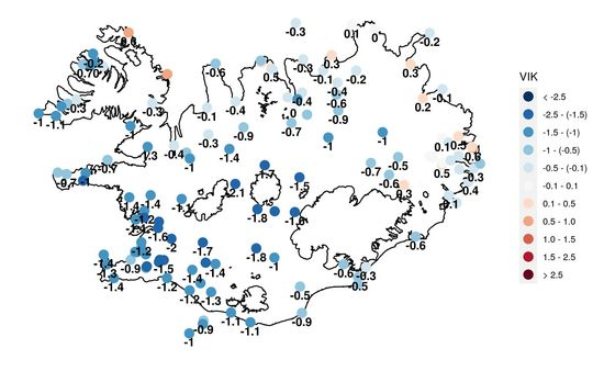
Image
[vedur.is]

The COLD TIMES are returning, the mid-latitudes are REFREEZING, in line with the great conjunction, historically low solar activity, cloud-nucleating Cosmic Rays, and a meridional jet stream flow (among other forcings).

Both NOAA and NASA appear to agree, if you read between the lines, with NOAA saying we’re entering a ‘full-blown’ Grand Solar Minimum in the late-2020s, and NASA seeing this upcoming solar cycle (25) as “the weakest of the past 200 years”, with the agency correlating previous solar shutdowns to prolonged periods of global cooling here.

Furthermore, we can’t ignore the slew of new scientific papers stating the immense impact The Beaufort Gyre could have on the Gulf Stream, and therefore the climate overall.


Prepare accordinglylearn the facts, relocate if need be, and grow your own.
 

TxGal

Day by day
Summer Snow forecast for Canada, as Record Cold Looms for the US (electroverse.net)

summer-snow-3-e1625485824492.jpg

Extreme Weather GSM

SUMMER SNOW FORECAST FOR PARTS OF CANADA, AS RECORD COLD LOOMS FOR THE UNITED STATES
JULY 5, 2021 CAP ALLON

Solar activity is the driving force of Earth’s climate.

This ‘definition of obvious‘ is only disputed by the misinformed, and/or those with a political motive.

History will view AGW proponents as entirely wrong, and of having reached a consensus without critical reasoning or evaluation of the alternatives for the purposes of restructuring society. They will be seen as unknowing puppets of the elites, and, in many cases, as dangerous, extremist individuals hellbent on pursuing a cause they haven’t a hope of fully understanding.

That’s some legacy to leave your grandchildren.

SUMMER SNOW FORECAST FOR PARTS OF CANADA

This week, swathes of Canada could see four seasons in seven days. MétéoMédia predicts temperatures of 35C in some areas of Quebec, with SNOW in others (see GSMs and the Swing Between Extremes).

“At the beginning of the week, over southern Quebec, temperatures will reach 35C –or even 40C– due to a very present humidex. However, this will be short-lived, as a system will pass over the province on Tuesday,” reads the first lines of the MétéoMédia forecast.

“Behind the cold front, temperatures will drop and the contrast will be well felt.

“This temperature contrast will be most pronounced for areas a little further north,” continues the forecast.

“There could be snow in some areas, such as Fermont”–which can expect daytime highs of just 4C (39.2F) on Wednesday.

The sudden drop in temperature is expected to lead to severe thunderstorms and wind gusts of up to 60 km/h.

Additionally, substantial snow is also forecast for British Columbia by mid-July:


GFS Total Snowfall — July 16 – July 21 [tropicaltidbits.com].

Where is the MSM reporting on Canada’s summer snow?

Where is their impartiality?

[not a serious question — I know exactly where it is — it’s up their %$*&!]

RECORD COLD LOOMS FOR THE UNITED STATES

And while the reality-warping MSM focuses on the West’s “heat dome”, stark negative temperature anomalies have been engulfing vast portions of the central United States for weeks now — cold which is forecast to persist as the month of July progresses.

Looking at the latest GFS run (shown below), a fresh mass of frigid Arctic air will drop down from Canada on Tuesday, July 6 — one which is set to force a rare summer chill as far south as central/southern Mexico.

Departures from the norm are expected to fall as much as 16-20C below the seasonal average:


GFS 2m Temperature Anomalies (C) for Tuesday, July 6 [tropicaltidbits.com].

The U.S. states of North and South Dakota will be among the worst hit on Tuesday.

While Florida can also expect a rare July chills.

The cold will intensify further on Wednesday, July 7, and will gain ground on eastern US states:


GFS 2m Temperature Anomalies (C) for Tuesday, July 7 [tropicaltidbits.com].

This coming weekend also looks very cold across the CONUS, particularly for the North-Central and South-Central US:

NORTH-CENTRAL US


GFS 2m Temperature Anomalies (C) for Saturday, July 11 [tropicaltidbits.com].

SOUTH-CENTRAL US


GFS 2m Temperature Anomalies (C) for Saturday, July 11 [tropicaltidbits.com].

Such stark anomalies will likely mean hundreds of new record-breaking low temperature readings.

Stay tuned to Electroverse for updates (you won’t hear them across the obfuscating MSM).

Subscribe to receive new post notifications by email (the box is located in the sidebar, or scroll down if on mobile).

ALASKA’S HARVEST WOES

Juneau, Alaska berrypickers and gardeners are wondering where their fruit is this year…

As reported by mtlblog.com, Master Gardener Ed Buyarski said berries have indeed been slow in 2021, even compared to last year’s historically cold and wet season.

Buyarski said blueberries are late, even the early April bloomers.

While Raspberry plants are also behind, by at least 10 days, likely more.

“Apples and cherries, likewise, are late by two to three weeks or more,” added Buyarski, who laments that there is really nothing that can be done other than “crossing your fingers for more sunshine and warm weather”; however, for cherry and apple trees, Buyarski suggests thinning may help.

“I think because of last year’s poor cold wet weather, that there may not be a lot of energy stored in the roots of the plants to ripen all those fruits,” Buyarski said; “so thinning may be especially important this year.”


The COLD TIMES are returning, the mid-latitudes are REFREEZING, in line with the great conjunction, historically low solar activity, cloud-nucleating Cosmic Rays, and a meridional jet stream flow (among other forcings).

Both NOAA and NASA appear to agree, if you read between the lines, with NOAA saying we’re entering a ‘full-blown’ Grand Solar Minimum in the late-2020s, and NASA seeing this upcoming solar cycle (25) as “the weakest of the past 200 years”, with the agency correlating previous solar shutdowns to prolonged periods of global cooling here.

Furthermore, we can’t ignore the slew of new scientific papers stating the immense impact The Beaufort Gyre could have on the Gulf Stream, and therefore the climate overall.


Prepare accordinglylearn the facts, relocate if need be, and grow your own.
 

TxGal

Day by day
Concord, NH just busted a Century-Old Low Temperature Record (electroverse.net)


cold-na-2-e1625557950568.png

Extreme Weather GSM

CONCORD, NH JUST BUSTED A CENTURY-OLD LOW TEMPERATURE RECORD
JULY 6, 2021 CAP ALLON

The past few days have delivered the lowest-maximum temperature in more than a century to Concord, New Hampshire, according to National Weather Service (NWS) data.

On Saturday, New Hampshire’s capital city of Concord logged a high temperature of just 59F (15C) — a reading that busted the previous coldest-high temperature of 61F set way back in 1914.

The year 1914 fell during the Centennial Minimum (and also the Solar Minimum of cycle 14), which is the last time the sun was experiencing a spell of reduced output comparable to what we’re seeing today:


Comparing SC14 and SC24 — Solar Cycle chart (1875 – 2020).

Concord’s record cold is confirmed by NWS meteorologist Michael Clair, who is based in Gray, Maine.

Clair notes that the historic chill came hot on the heels of the heat wave and near record-high temperature of 96F (35.5C) last Thursday.

Thursday’s high didn’t quite usurp the all-time benchmark, which still still stands as the 97F (36.1C) registered back in 1964, according to NWS records. The year 1964 also fell during a Solar Minimum (of cycle 19), and so again demonstrates the link between low solar activity and meridional jet stream flows — a combo that routinely throws weather patterns ‘out of whack’ (see the two links below for a more detailed explanation).


And while last Thursday’s 96F no doubt had climateers calling for ‘AGW lockdowns’ and an ‘end to life as we know it’, what these misinformed puppets of the elites fail to grasp is that Earth is older than just a few decades.

Even our temperature records span 100+ years in many locales (352 years in the case of the UK), and even this relatively short climatological window shows us that that we’re been here before, many times, and that nothing unprecedented is happening.

Case in point: back in 1911, the New Hampshire/Maine region was suffering one of its “worst weather crisis in its history” (note: it was called ‘weather’ back then, not ‘climate’) as a July heat wave cooked the entire Eastern seaboard, with factories shutting down and people collapsing in the streets.

Note also that the year 1911 fell smack-bang in the middle of the Centennial Minimum and after the historically weak solar cycle of 14 (again, the previous cycle comparable to the cycle we’ve just witnessed, SC24).

Everybody “suffered as never before,” reported the Lewiston Evening Journal at the time.

Thermometers touched 110F (43.3F) on July 10, 1911, and many of them broke when they got too hot, reports unionleader.com.

“Never was there a worse night in the history of Lewiston and Auburn than the one that began after an exhausting, humid day in July 10,” added the Lewiston Evening Journal, “hitting a crazy overnight low of 75F (24F).”

That “worse day” sill hasn’t been surpassed, even after 40+ years of ‘catastrophic global heating’.


“We have a warm-up coming (on Tuesday),” said Clair, who is then expecting another cold front to move in Wednesday — a forecast which is supported by the GFS which sees record cold sweeping swathes of North America all week:

gfs_T2ma_namer_8.png

GFS 2m Temp Anomalies (C) for Weds, July 7. Note the stark temperature contrast between the West and Central/Eastern regions: another example of low solar activity induced meridional jet stream flows, and also of GSM’s and the swing between extremes.


The COLD TIMES are returning, the mid-latitudes are REFREEZING, in line with the great conjunction, historically low solar activity, cloud-nucleating Cosmic Rays, and a meridional jet stream flow (among other forcings).

Both NOAA and NASA appear to agree, if you read between the lines, with NOAA saying we’re entering a ‘full-blown’ Grand Solar Minimum in the late-2020s, and NASA seeing this upcoming solar cycle (25) as “the weakest of the past 200 years”, with the agency correlating previous solar shutdowns to prolonged periods of global cooling here.

Furthermore, we can’t ignore the slew of new scientific papers stating the immense impact The Beaufort Gyre could have on the Gulf Stream, and therefore the climate overall.


Prepare accordinglylearn the facts, relocate if need be, and grow your own.
 

TxGal

Day by day
Why is nobody talking about Greenland? It's currently GAINING record amounts of Snow and Ice... (electroverse.net)

Greenland-GAINS-e1625566872403.jpeg

Articles Extreme Weather GSM

WHY IS NOBODY TALKING ABOUT GREENLAND? IT’S CURRENTLY GAINING RECORD AMOUNTS OF SNOW AND ICE…
JULY 6, 2021 CAP ALLON

On the back of substantial Surface Mass Balance (SMB) gains since 2016 (which coincide with a stark drop in Earth’s average temperature), the Greenland ice sheet is increasing that trend of GROWTH in 2021.

Despite MSM obfuscations, vast regions of Greenland are currently gaining record levels of snow and ice.

Back on May 26, a single day gain of more than 12 gigatons was logged which sent the official SMB chart –courtesy of the Danish Meteorological Institute (DMI)– into unprecedented territory.

The May 26 reading shot that blue line off the charts, literally:


May 26’s’of the charts’ SMB gains [DMI].

Further record-breaking GAINS were logged throughout June.

Most notably on June 24, when a gain of 4 gigatons was logged.

This was an astonishing accumulation for the time of year — never before in the month of June had the Greenland ice sheet grown by 4 Gts in a single day (according to DMI data which extends to 1981).


Greenland SMB gains (to July 5, 2021) [DMI].

According to the climate alarmists, the Greenland ice sheet should have melted into oblivion by now — yet here we are, posting record July gains which in turn are pushing this year’s balance above the 1981-2010 mean:


Greenland SMB gains [DMI] — note how this 2021’s gains (blue line in the bottom graph) have burst through the 1981-2010 mean (grey line).

Earth’s climate is cyclic, it isn’t linear.

The spell of global warming we witnessed can be tied to high solar output, while the period of cooling we experienced prior to this (from around 1960 to 1980) can be linked to low solar activity.

To believe that the natural order of things has somehow been thrown off course by human carbon dioxide emissions is sheer folly — this theory isn’t backed up by the raw temperature data charts, for example (you know, the ones before government agencies make their ‘adjustments’ — see the link below for more on that).


We’ve had some 40+ years of ‘catastrophic global warming’ now, but even the staunchest of climateers will still struggle to point to a single real-world observation that demonstrates its existence.

Deadly heat waves have ALWAYS occurred, as have hurricanes, as have extreme polar outbreaks — to now circumvent logic and ignore historical documentation in order to pin all these weather events on human CO2 emission is laughable.

Deaths due to climatological events and natural disasters are at an all-time low, yet the gullible masses keenly lap up the EOTW rhetoric spouted by the IPCC and their MSM lapdogs.

This cataclysmic message is enticing, and it gives meaning to people’s otherwise benign existence. It appears to fill the gap once occupied by religion, for there is nothing that exerts such powerful control over a population than the threat of the ‘end of days’–when all Christian believers will rise “in the clouds, to meet the Lord in the air.”

Climate Change is the new religion.

It pushes the exact same buttons Christianity, for example, does — it threatens the end of days if you don’t comply, it asks for great sacrifices, and for a seismic change in the way you live; it prevents you from fully enjoying life, and acts as a nagging force in your mind, constantly preying on your deepest fear: mortality.

This incessant worry acts as a blocker to open thought, to freedom of speech, and to debate.

It shuts down reasoned discussions, meaning the masses are never privy to the other side of the dogma.

The data simply doesn’t support notions of a ‘Climate Crisis,’ it no longer supports even a mild bout of global warming. Since 2016 our planet has been cooling, down some 0.7C in those 5 years.

Additionally, the 15x NASA/NOAA AMSU satellites that measure every square inch of the lower troposphere (where us humans reside), reveal that we’ve once again dropped below the 30-year average; that is, Earth’s temperature is cooler now, in June, 2021 than it was back in 1983:


That’s right, despite the mainstream media’s incessant EOTW ramblings re the Pacific Northwest’s heat, Earth’s average temperature actually fell below the 30-year baseline in June.

And that’s the point.

The real-world data no longer supports the AGW theory –it was shaky at best– and so the language used by the MSM, by power-hungry politicians, and by the world’s pop-scientists has become evermore hyperbolic.

This is in order to distract from the fact that the hypothesis has failed.

If the ‘Climate Emergency’ was indeed a real thing, it wouldn’t take such a partisan marketing campaign to convince everyone of its existence. It wouldn’t require the censorship of sites like Electroverse, which was recently banned from Facebook, routinely has its Twitter followers purged, and at the start of the had its advertising removed — all because I dared to say that the data suggest Earth is cooling, not warming.

The exaggerated language consciously used by the likes of The Guardian, and their extreme-leftist peers, is then parroted by a small yet noisy band of placard-brandishing street-warriors who’s message is then in turn heard by placating politicians, and then subsequently rushed into economy-wrecking policy.

Those eco-parties are soon voted out of power, when the masses get wind of their aim, but often the damage is already done; there is such a political correctness attached to AGW these days that it takes a strong will to combat it.

But fight it we must.

It’s the biggest scam going.

The raw data proves this, daily:


Greenland SMB gains (to July 5, 2021) [DMI].

The Sun defines the climate, not carbon dioxide,” says eminent Russian space scientist, Habibullo Abdussamatov (Dr. Sc. – Head of Space research laboratory of the Pulkovo Observatory).

Observations of the Sun show that carbon dioxide is “not guilty” for the steady increase in temperature observed over the past few decades, and that what lies ahead in the coming years is not catastrophic warming but a global and very prolonged temperature drop.

The slight warming we just experienced had a natural origin, the contribution of CO2 was insignificant — carbon dioxide does not serve as an explanation, the Sun does.

The so-called ‘greenhouse effect’ will not avert the onset of the next deep temperature drop, the 19th in the last 7500 years, which without fail follows after natural warming.

“We should fear a deep temperature drop — not catastrophic global warming,” warns Abdussamatov, who was one of the researchers featured in the 2009 U.S. Senate Report of More Than 700 Dissenting Scientists Over Man-Made Global Warming.

“Humanity must survive the serious economic, social, demographic and political consequences of a global temperature drop, which will directly affect the national interests of almost all countries and more than 80% of the population of the Earth.”


The COLD TIMES are returning, the mid-latitudes are REFREEZING, in line with the great conjunction, historically low solar activity, cloud-nucleating Cosmic Rays, and a meridional jet stream flow (among other forcings).

Both NOAA and NASA appear to agree, if you read between the lines, with NOAA saying we’re entering a ‘full-blown’ Grand Solar Minimum in the late-2020s, and NASA seeing this upcoming solar cycle (25) as “the weakest of the past 200 years”, with the agency correlating previous solar shutdowns to prolonged periods of global cooling here.

Furthermore, we can’t ignore the slew of new scientific papers stating the immense impact The Beaufort Gyre could have on the Gulf Stream, and therefore the climate overall.


Prepare accordinglylearn the facts, relocate if need be, and grow your own.
 

TxGal

Day by day

Publius

TB Fanatic
Concord, NH just busted a Century-Old Low Temperature Record (electroverse.net)


cold-na-2-e1625557950568.png

Extreme Weather GSM

CONCORD, NH JUST BUSTED A CENTURY-OLD LOW TEMPERATURE RECORD
JULY 6, 2021 CAP ALLON

The past few days have delivered the lowest-maximum temperature in more than a century to Concord, New Hampshire, according to National Weather Service (NWS) data.

On Saturday, New Hampshire’s capital city of Concord logged a high temperature of just 59F (15C) — a reading that busted the previous coldest-high temperature of 61F set way back in 1914.

The year 1914 fell during the Centennial Minimum (and also the Solar Minimum of cycle 14), which is the last time the sun was experiencing a spell of reduced output comparable to what we’re seeing today:


Comparing SC14 and SC24 — Solar Cycle chart (1875 – 2020).

Concord’s record cold is confirmed by NWS meteorologist Michael Clair, who is based in Gray, Maine.

Clair notes that the historic chill came hot on the heels of the heat wave and near record-high temperature of 96F (35.5C) last Thursday.

Thursday’s high didn’t quite usurp the all-time benchmark, which still still stands as the 97F (36.1C) registered back in 1964, according to NWS records. The year 1964 also fell during a Solar Minimum (of cycle 19), and so again demonstrates the link between low solar activity and meridional jet stream flows — a combo that routinely throws weather patterns ‘out of whack’ (see the two links below for a more detailed explanation).


And while last Thursday’s 96F no doubt had climateers calling for ‘AGW lockdowns’ and an ‘end to life as we know it’, what these misinformed puppets of the elites fail to grasp is that Earth is older than just a few decades.

Even our temperature records span 100+ years in many locales (352 years in the case of the UK), and even this relatively short climatological window shows us that that we’re been here before, many times, and that nothing unprecedented is happening.

Case in point: back in 1911, the New Hampshire/Maine region was suffering one of its “worst weather crisis in its history” (note: it was called ‘weather’ back then, not ‘climate’) as a July heat wave cooked the entire Eastern seaboard, with factories shutting down and people collapsing in the streets.

Note also that the year 1911 fell smack-bang in the middle of the Centennial Minimum and after the historically weak solar cycle of 14 (again, the previous cycle comparable to the cycle we’ve just witnessed, SC24).

Everybody “suffered as never before,” reported the Lewiston Evening Journal at the time.

Thermometers touched 110F (43.3F) on July 10, 1911, and many of them broke when they got too hot, reports unionleader.com.

“Never was there a worse night in the history of Lewiston and Auburn than the one that began after an exhausting, humid day in July 10,” added the Lewiston Evening Journal, “hitting a crazy overnight low of 75F (24F).”

That “worse day” sill hasn’t been surpassed, even after 40+ years of ‘catastrophic global heating’.


“We have a warm-up coming (on Tuesday),” said Clair, who is then expecting another cold front to move in Wednesday — a forecast which is supported by the GFS which sees record cold sweeping swathes of North America all week:

gfs_T2ma_namer_8.png

GFS 2m Temp Anomalies (C) for Weds, July 7. Note the stark temperature contrast between the West and Central/Eastern regions: another example of low solar activity induced meridional jet stream flows, and also of GSM’s and the swing between extremes.


The COLD TIMES are returning, the mid-latitudes are REFREEZING, in line with the great conjunction, historically low solar activity, cloud-nucleating Cosmic Rays, and a meridional jet stream flow (among other forcings).

Both NOAA and NASA appear to agree, if you read between the lines, with NOAA saying we’re entering a ‘full-blown’ Grand Solar Minimum in the late-2020s, and NASA seeing this upcoming solar cycle (25) as “the weakest of the past 200 years”, with the agency correlating previous solar shutdowns to prolonged periods of global cooling here.

Furthermore, we can’t ignore the slew of new scientific papers stating the immense impact The Beaufort Gyre could have on the Gulf Stream, and therefore the climate overall.


Prepare accordinglylearn the facts, relocate if need be, and grow your own.


In this day and age a temperature record low of two degrees at any time of year is a big deal.
 

TxGal

Day by day
An intense, early-season chill has been "Ravaging" East Africa's Crops (electroverse.net)


ravage-crops-africa-e1625644407426.jpg

Crop Loss Extreme Weather GSM

AN INTENSE, EARLY-SEASON CHILL HAS BEEN “RAVAGING” EAST AFRICA’S CROPS
JULY 7, 2021 CAP ALLON

Farmers across east Africa are counting their losses as an unusual chill continues to blast the region.

According to the Kenya Meteorological Department, the cold of winter started earlier than usual this year, in May, rather than during the expected month of July.

The chill has been ravaging growing regions across east Africa, reports xinhuanet.com, with the mercury in some regions plummeting close to freezing, which is astonishing.

In Nairobi, the capital city of Kenya, the average overnight low has been 10C (50F), with the daytime highs averaging at 18C (64F) — these readings are some 8C (14F) and 6C (11F) below the seasonal averages, respectively, according to the Department data.

“The cold weather provides a perfect environment for diseases, in particular blight, to thrive,” says Beatrice Macharia, an agronomist with Growth Point.

Macharia notes that farmers growing crops in the field, in particular tomatoes; capsicums (peppers); cucumbers; potatoes; and onions, are having it rough due to the unusually fierce (and persistent) cold.

“They have to spend more, and fight the disease through the use of chemicals that protect the crops but still this is not working for some,” laments Macharia, who is deeply concerned by “the lengthy cold season this year, with temperatures falling to the lowest levels.”

She continues: “In areas in the Rift Valley, like Nyandarua –where temperatures are regularly falling to 3C (37F)– even with the application of chemicals the chances of survival for field horticultural crops are too low.”

Macharia suggests that growing crops in greenhouses may be the way forward, as such structures protect crops from blight by holding the mercury some 5C above the outside temperature, she says.


Cold-damaged Tomato crop.

Bernard Njuguna, a farmer in the Rift Valley, is among those counting his losses due to the cold weather.

Njuguna sowed his field tomatoes in late April, and expected to reap the rewards three months later.

Unfortunately though, the historic chill that hit Nyandarua wiped-out his crop just as it was at the key flowering stage.

Njuguna lost his entire harvest, even after using various chemicals in an attempt to save it.

“The crop on the entire half-acre withered; the leaves and the stems dried leaving me with losses,” he said.

He has since erected a greenhouse on his farm following advice from agricultural officers.

But with few farmers growing crops in greenhouses as compared to open fields, the supply of fresh produce in east Africa has declined dramatically in recent months, and has resulted in prices soaring.

A kilo of tomatoes, for example, is currently being sold at 0.74 dollars, up from 0.46 dollars in April.

The cost of other horticultural produce has also skyrocketed, pushing up food inflation in east Africa.

Laughably, Macharia attributes this historic and early-season cold to the mythical beast that is “climate change”.

Global warming, she says, is responsible for ravaging Kenya’s breadbaskets, “with the weather oscillating between cold, dry spells to periods with little rainfall” (aren’t dry spells and periods with little rainfall the same…?).

It’s getting somewhat tiring combating the daily misinformation campaign re AGW.

The world’s so-called academics are blindly trusting a theory built upon the work of just a few climate modelers.

You can picture today’s ‘global warming science’ as an upside down pyramid, says Dr. Mototaka Nakamura.

These AGW pioneers claim to have demonstrated human-derived CO2 emissions as the cause of recently rising temperatures and have then simply projected that warming forward.

Every climate researcher thereafter has taken the results of these original models as a given, and we’re even at the stage now where merely testing their validity is regarded as heresy.

No, global warming does not mean crop-destroying cold in eastern Africa.

Nor does it explain the heavy frosts ravaging the sugarcane, coffee and corn crops in South America:


Or the record July cold sweeping large swathes of North America:


And neither does it explain Earth’s average temperature dropping below the 30-year average in June:


These are the facts.

They are undeniable.

I don’t know why me mentioning them gets so many people up in arms.

Dogma is a powerful weapon, I guess.

The COLD TIMES are returning, the mid-latitudes are REFREEZING, in line with the great conjunction, historically low solar activity, cloud-nucleating Cosmic Rays, and a meridional jet stream flow (among other forcings).

Both NOAA and NASA appear to agree, if you read between the lines, with NOAA saying we’re entering a ‘full-blown’ Grand Solar Minimum in the late-2020s, and NASA seeing this upcoming solar cycle (25) as “the weakest of the past 200 years”, with the agency correlating previous solar shutdowns to prolonged periods of global cooling here.

Furthermore, we can’t ignore the slew of new scientific papers stating the immense impact The Beaufort Gyre could have on the Gulf Stream, and therefore the climate overall.


Prepare accordinglylearn the facts, relocate if need be, and grow your own.
 

TxGal

Day by day
The MSM falls silent as Siberia shifts from Record Heat to Record Cold (electroverse.net)

siberia-summer-chills-e1625656888174.jpg

Extreme Weather GSM

THE MSM FALLS SILENT AS SIBERIA SHIFTS FROM RECORD HEAT TO RECORD COLD
JULY 7, 2021 CAP ALLON

Record-setting COLD does’t suit the AGW agenda, this is clear — mainstream reporting on such climatological phenomena is very reluctant, and always comes with the caveat that “climate change” is the root cause.

Polar outbreaks that sweep western nations do receive some MSM coverage (such as we saw during Texas’ historic freeze during which 702 people died); however, this is only because hundreds of millions of westerners will be physically feeling the cold, and looking for answers — believe me, if the likes of CNN felt they could get away without documenting Texas’ deadly February freeze, then they would.

The MSM has made it their mission to paint the world as a flaming inferno.

To achieve this, CNN (who were recently caught saying they can “milk climate change for at least another few years”), routinely cherry-pick pockets of heat while ignoring historic bouts of anomalous cold — if a freeze doesn’t directly impact westerners then the MSM can leave it unreported, which means their readers/viewers never receive a balanced view of Earth’s climate.

This calculated approach is responsible for stirring-up ‘climate hysteria’.

People are’t getting both sides of the story.

They are being propagandized.

And the weather in Siberia is a good case in point.

The mainstream media was all-too keen to point out Siberia’s recent heatwave, running irresponsible headlines such as “Climate Change is Frying the Northern Hemisphere“, but where were these charlatans during Russia’s historically frigid winter?

Back in December, an immense mass of Arctic cold gripped 80+ percent of the 17.1 million km² transcontinental nation, cold that then only expanded and intensified as the winter season progressed.

Siberia wound-up suffering one its coldest starts to the year on record.

Temperatures across the vast Asian region held more than 20C below the seasonal average as Arctic air rode anomalously-far south on the back of a weak and wavy meridional jet stream flow: lows of -50C (-58F) and even -60C (-76F) swept the region for long periods–readings among the lowest-ever recorded in the Northern Hemisphere.

Asia’s prolonged winter chills led to both food and energy prices soaring to record highs. They also resulted in thousands of reindeer starving to death on Russia’s Yamal Peninsular due to the animals’ forage being locked under unusually thick ice this year (and where was CNN when members of a scientific expedition to the area called for “new urgent ideas to rescue herding in the region due to an increase in periodic glaciation”?).


SIBERIA SHIFTS TO RECORD COLD

The MSM will soon fall silent re Siberia, for the reasons highlighted above — the heatwave is subsiding, and record cold now looms over the vast Russian province.

Looking at the latest GFS run (shown below), a stark shift is on the cards as a violent buckling of the jet stream drags extreme polar cold unusually-far south.

The chill has already taken hold in the far north; but by the end of the week, anomalous cold will have engulfed many eastern areas, too.

And then eyeing further ahead still, and into next week, temperature departures will tumble some 20C below the seasonal average across central Asia:


GFS 2m Temp Anomalies for July 14 (pinks indicate 16-22C below average) [tropicaltidbits.com].

These departures from the norm are set to deliver record low temperatures as far south as Mongolia.

Additionally, rare bands of heavy summer snow are forecast to stretch all the way down to western China:


GFS Total Snowfall (cm) July 7 to July 14 [tropicaltidbits.com].

Rare summer snow fell across China’s higher elevations last year, too, including in the Qilian Mountains.

The towns of Huangcheng, Mati, Kangle and Dahe were among those blanketed by the unusual snowfall, which “amazed netizens (users of the internet)”, reported chinadaily.com.cn at the time.


Summer snow in the Qilian Mountains on June 7, 2020 [Wu Xuefeng/chinadaily.com.cn]


A stunning view of China’s summer snow in 2020. [Wu Xuefeng/for chinadaily.com.cn]

Similarly, the MSM were ‘caught out’ by Siberia’s switch from record heat to record cold last year, too.

Fear laden articles such as “The Arctic Is On Fire, and We Should all Be Terrified” were being published even as Verkhoyansk –the town at the heart of the media’s heat-induced tizzy in June, 2020– was experiencing rare summer snow.

Seldom reported is the fact that this region of the planet is accustomed to drastic swings in temperature — the mercury regularly holds below -50C (-58F) in winter and above 30C (86F) in summer–and the town Verkhoyansk, it turns out, has long-held the record for having the greatest temperature range on Earth (another fact the MSM deliberately keeps from the masses).


The COLD TIMES are returning, the mid-latitudes are REFREEZING, in line with the great conjunction, historically low solar activity, cloud-nucleating Cosmic Rays, and a meridional jet stream flow (among other forcings).

Both NOAA and NASA appear to agree, if you read between the lines, with NOAA saying we’re entering a ‘full-blown’ Grand Solar Minimum in the late-2020s, and NASA seeing this upcoming solar cycle (25) as “the weakest of the past 200 years”, with the agency correlating previous solar shutdowns to prolonged periods of global cooling here.

Furthermore, we can’t ignore the slew of new scientific papers stating the immense impact The Beaufort Gyre could have on the Gulf Stream, and therefore the climate overall.


Prepare accordinglylearn the facts, relocate if need be, and grow your own.
 

TxGal

Day by day
Manitoba municipality declares state of agricultural disaster due to drought, record-breaking heat | CBC News

Manitoba municipality declares state of agricultural disaster due to drought, record-breaking heat

The lack of rain, along with the heat dome, has been stressing crops and producers in the province

Marianne Klowak · CBC News · Posted: Jul 06, 2021 5:00 AM CT | Last Updated: July 6

manitoba-drought.jpg

A group that represents Manitoba farmers says parts of the province are in rough shape. (Tyson Koschik/CBC)

Relentless heat, record-breaking temperatures and a lack of rain are pushing some Manitoba farmers over the edge.

The Rural Municipality of St. Laurent, in the Interlake region, declared an agricultural state of disaster on Monday after weekend temperatures reached the mid-30s C over the weekend.

The municipality says it has received less than 40 per cent of the normal amount of rain so far this year, crop yields are coming in at excessively low volumes, and dugouts and wells are dry or drying up.

Water supply and water quality is a growing concern, while a grasshopper infestation is compounding the lack of forage, the municipality said.
Deputy Reeve Frank Bruce said some farmers are being forced to sell their livestock because of the high cost of feed and water. He calls the farmers' plight desperate.

"Some are selling off their cattle because of the dryness. It is a disaster. Many don't have water," said Bruce. "They are getting wells dug up and are actually hauling water from the lake into the dugouts.

"And on top of this, grasshoppers are eating their crops. There is an infestation."

The extreme economic impact has forced council to ask for immediate assistance through provincial and federal programs, Bruce said.

A provincial spokesperson said in an email the government is working closely with municipalities and producers and is offering a number of resources and supports to those who need it.

Interlake in rough shape

Bill Campbell, president of Manitoba's Keystone Agricultural Producers, isn't surprised. He said the Interlake is very dry and in rough shape. So are many other areas in the province.

KAP represents about 4,500 farmers in the province and around 21 commodity groups.
"There is probably irreversible damage to the crops, the hay and the pastures," said Campbell.

"With this heat there will be pod abortion, and the wheat won't be as good as it could be. It's just too much stress and you don't get it back. You can't repair that at this stage of the game."

Campbell said it's too early to know the monetary value of the damage. He said farmers measure what goes into the bin, and those numbers aren't available yet.

While isolated showers did bring some optimism in mid-June, Campbell says the heat dome over the weekend has left farmers worried and concerned if harvest will be earlier than usual this year.

"Beetles ravaging canola, frost and cold temperatures in the spring, poor germination and then re-seeding, it's almost like your emotions are a yo-yo. You go up and down," he said. "Then this blast of intense heat.

"While we know a lot about how to deal with adversity, Mother Nature holds the trump card, and we haven't had enough rain."

bill-campbell-s-dry-and-scorched-fields-south-of-brandon.jpeg

Bill Campbell's mixed farm of cereals and purebred livestock has been hit hard by a lack of precipitation and intense heat. (Bill Campbell)

He is worried about the lack of water for his purebred livestock too, citing a lack of snowfall this winter and spring runoff.

"The dugouts, the creeks didn't replenish. And you know whatever limited rainfall there was, there was no runoff. The dugouts are dry and empty," said Campbell.

"Without water on a pasture, it becomes a problem for cattle. They need to drink everyday. And on Saturday and Sunday, they would have in excess of 10 gallons per animal. If you don't have water, you have to move them."

He has had to build a fence and move his cattle back to the well, putting in shallow pumps to access water and trench it to the pasture.

'We get one chance at this'

Larry Wagner says anything that was stressed before the heat wave is going downhill fast.

Wagner is a cattle producer near Virden, Man. He's also the chair of the Manitoba Forage and Grasslands Association.
He's also worried about an early harvest.

"Some of the crops are on the verge of being written off and then they can be harvested as feed for livestock. Some of them won't make a crop. We just have to keep going and salvage what we can," said Wagner.

An early harvest indicates premature ripening, that there is less than what there could be. An early harvest is not a good sign, said Campbell.

"We get one chance at this every year. We can't fix it if the rain doesn't show up. We will be having to make some major decisions on how we as producers cope with the consequences of this weather," he said.
 

Publius

TB Fanatic
Oddly crops like corn is doing well here in West Virginia and should yield decent crop.
Now my peaches all fell of the trees this year and thinking I going to get some peaches this year for the first time in four years but nope, also all the black walnut trees are dropping their nuts starting back in June so no black walnuts this year, not sure how the acorns are doing this year as it's to early to tell.
 

TxGal

Day by day
Adapt 2030 has a new podcast out:

Are Intensifying Solar System Magnetic Fields Affecting Earth's Crust - YouTube

Are Intensifying Solar System Magnetic Fields Affecting Earth's Crust
12,006 views
Premiered 20 hours ago

View: https://youtu.be/uYFurN5QWOQ
Run time is 11:07

Synopsis provided:

So many strange incidents of collapse and fire across the planet all in the same weeks, so it makes me wonder if its related to the solar system's second magnetic field forming. What if Ley Lines or Veins of Minerals began to vibrate faster and heat up?
 

TxGal

Day by day
Anyone know what’s up with Christian from Ice Age Farmer? He hasn’t posted a video in over 2 weeks.

Some time back he started posting less on the GSM and more on the Deep State stuff. He does have a new one posted now, more food-related (but that does have relevance to the GSM to a certain extent, prep-wise):

"Rolling Shortages" of Food? UK's Meat Tax & Food Riots - YouTube

"Rolling Shortages" of Food? UK's Meat Tax & Food Riots
41,845 views
Jul 7, 2021

View: https://youtu.be/SQytRAX0dg0
Run time is 17:49

Synopsis provided:

The UK is now experiencing "rolling brownouts of food supply," as advisors warn there may be "food riots" in the weeks ahead as food prices escalate to unaffordable levels and shelves are emptied. This is coming soon to the USA and Europe. In the "new normal" of the Great Reset, you will take whatever lab-grown meat is made available to you -- or will you start growing your own food now?
 

TxGal

Day by day
Summer Snow and Sub-Zero Lows Sweep Canada, as South America Freeze (electroverse.net)

summer-snow-canada-e1625734366980.jpg

Extreme Weather GSM

SUMMER SNOW AND SUB-ZERO LOWS SWEEP CANADA, AS SOUTH AMERICA CONTINUES TO FREEZE
JULY 8, 2021 CAP ALLON

A severe summer chill has invaded large pockets of Canada.

The Arctic invasion has brought temperatures plummeting below zero (C) in northern parts — the mercury in Cape Dyer, Naunavut, for example, has tumbled to -5.4C (22F).

Summer snow is also settling, predominantly on the north coast of Labrador.

Below is a shot of the rare accumulating flakes at Voisey’s Bay from July 7, courtesy of @SeanLyall on Twitter:

View: https://twitter.com/SeanLyall/status/1412707684302954497


Worth also noting is how Armstrong, Ontario and Gillam, Manitoba went from 35C+ to a summer freeze in barely 3 days — yet another example of the Grand Solar Minimum and the swing between extremes.

Looking ahead, two-thirds of the North American continent will suffer further anomalous chills this week:


GFS 2m Temp Anomalies (C) for Thursday, July 8 [tropicaltidbits.com].

While Canada’s exceptional summer snowfall is forecast to intensify and spread westwards to British Columbia, the Yukon and the Northwest Territories:


GFS Total Snowfall (inches) July 8 – 24, with the heaviest snow in western Canada expected between July 15 – 17 [tropicaltidbits.com].

Note the incredible totals forecast for Greenland, too.

These will only add to the exceptional SMB growth witnessed this season:


The island’s latest data point (shown below), courtesy of the Danish Meteorological Department (DMI), reveals that further unprecedented GAINS of 2 Gigatons were logged yesterday, July 7.

Never before at this time of year (aka summer) has the Greenland ice sheet actually GAINED mass.


Greenland SMB gains (to July 7, 2021) [DMI].

But nobody’s talking about Greenland — and as with Canada’s summer snow, and North America’s anomalous chill, we can add the icy island’s real-world observations to the ever-growing list of ‘unreported weather phenomena’, as the obfuscating MSM focuses ALL its attention on the West’s heat; that is, despite Earth’s average temperature falling below the 30-year baseline in June:


SOUTH AMERICA CONTINUES TO FREEZE

BOLIVIA
June, 2021 in Bolivia came out colder than average, according to the country’s meteorological agency.

A few positive anomalies prevailed in the Andina regions, but the majority of locales, particularly those at low elevations, were routinely bombarded by polar blasts.

ARGENTINA
June, 2021 in Argentina also finished-up colder than average, most notably across the north of the country.
It was also drier than normal for most, except for few areas in the NW where positive precipitation anomalies were logged.

Image
[SMN]

Record lows and snows have swept Argentina in recent weeks:


In fact, the majority of the South America continent has been dealing with record-breaking chills:


The continent’s’s early-season cold snap is persisting into July, too, as a colder-than-average Antarctica continues to ‘fling’ frigid polar air masses to the lower latitudes.

Looking at the latest GFS run (shown below), much of the same is on the cards for the remainder of the month.

After a brief warm-up this week, temperature anomalies are set to nosedive again beginning July 16.

And by Saturday, July 17, a monster mass of polar cold is expected to have engulfed northern Argentina, Uruguay, Paraguay, Bolivia, and southern Brazil:


GFS 2m Temp Anomalies (C) for July 17 [tropicaltidbits.com].

These cold anomalies are forecast to intensify by July 22, to levels some 22C below the seasonal norm:


GFS 2m Temp Anomalies (C) for July 22 [tropicaltidbits.com].

THE COLD MATTERS

“Non-optimal” temperatures kill more than 5 million people globally, according to a new study.

But note the phrasing: “non-optimal”.

Knowing the scientific establishment and their MSM lapdogs as we do –as filthy warm-mongers– this wording should immediately lead you to assume that COLD is to blame for the majority of deaths, otherwise the title would have specifically stated “heat” — and after delving down into the detail, you would be right…

To better understand how weather affects a person’s health, scientists from Monash University in Melbourne compared death and temperature data across the world from 2000 to 2019 — during the final throws of solar-induced global warming (which ended ≈2016).

Results, published in The Lancet Planetary Health, suggest that 9.43 percent deaths could be attributed to those “non-optimal” temperatures, equivalent to 74 extra deaths per 100,000 people; which, in English, breaks down to just 0.91 percent from heat, and 8.52 percent from the cold.

The cold kills.

The heat, not so much.

This should be the takeaway from the study; however, Prof Yuming Guo’s take, who is one of the paper’s lead researchers, is somewhat different: “If we don’t take any action to mitigate climate change … more deaths will be caused,” he told The Guardian (well, how else would his study have obtained funding?).

The Guardian, along with their climateering cronies, will have their day of reckoning.
It’s coming.

The Sun will see to that.

The COLD TIMES are returning, the mid-latitudes are REFREEZING, in line with the great conjunction, historically low solar activity, cloud-nucleating Cosmic Rays, and a meridional jet stream flow (among other forcings).

Both NOAA and NASA appear to agree, if you read between the lines, with NOAA saying we’re entering a ‘full-blown’ Grand Solar Minimum in the late-2020s, and NASA seeing this upcoming solar cycle (25) as “the weakest of the past 200 years”, with the agency correlating previous solar shutdowns to prolonged periods of global cooling here.

Furthermore, we can’t ignore the slew of new scientific papers stating the immense impact The Beaufort Gyre could have on the Gulf Stream, and therefore the climate overall.


Prepare accordinglylearn the facts, relocate if need be, and grow your own.
 

TxGal

Day by day
Arctic Front to Buffet Europe + the Schooling System and Mindless Robots (electroverse.net)


robot-child-scaled-e1625742157842.jpeg

Articles Extreme Weather GSM

ARCTIC FRONT TO BUFFET EUROPE + THE SCHOOLING SYSTEM AND MINDLESS ROBOTS
JULY 8, 2021 CAP ALLON

Despite the raggy ramblings of MSM outlets such as the express.co.uk –which claim that a “weeklong heatwave” is about to the grip the UK with “temperatures set to soar to 30C”– weather models suggest a rather different climatic reality is about to hit…

The United Kingdom, along with much of western/central Europe –including Spain, France, Italy, Belgium, the Netherlands, Germany, Czechia, Poland, Hungary, Bosnia, Serbia, the Ukraine, and Poland— are set to suffer unusual summer chills as an Arctic front gets funneled anomalously-far south on the back of weak and wavy ‘meridional’ jet stream flow.

The cold has already been sweeping far-Western Europe this week — cold I can attest to here in Portugal; but looking ahead, latest GFS runs (shown below) reveal harsher, record-challenging lows will descend into the continent beginning Thursday and Friday this week.

This summer cold will then really take hold by July 12…


GFS 2m Temp Anomalies for July 12 [tropicaltidbits.com].

..and will intensify further as next week progresses, driving temperature anomalies some 12C below the seasonal average by July 14 — this is despite the ‘wishful thinking’ of the express.co.uk, which are informing Brits to “pack away the umbrella and get out that sunblock again…temperatures of up to 86F (30C) are on their way.”


GFS 2m Temp Anomalies for July 14 — note the chill descends all the way down to N. Africa, too [tropicaltidbits.com].

As is often the case with the media, I don’t know what the hell they’re bleating on about.

But I also don’t really care.

If you consume the MSM then you’re being conditioned into seeing the world in a certain light, in a way the controlling elites see fit: most recently, that ‘COVID-19 is killing us, Global Warming is killing us, and Racial Inequality is killing us’ (note the theme — it is always one of division, and fear).

This conditioning begins in school, of course, where young multifaceted minds are quickly circled and stuffed into the one-thinking order of things. Our youth is molded into becoming productive and compliant members of society, with the latter taking precedence; compliance is key.

The education ‘system’ teaches you nothing of the real-world, and, despite its mantra, is not in anyway keen on broadening a child’s horizons — the system wants unquestioning robots, and that’s what the convener belt produces: an endless line of mindlessly trusting sheep that concern themselves not with the authoritative thumb under which they find themselves, but instead with the trivial routine/exertions of the daily grind, and, in the most indoctrinated of cases, with the fabricated/exaggerated ’emergencies’ of the time (listed above).

There has been no better example of this ‘blind trust’ than the occurrences of the last 18 months.

Is it Time to Stop Running Our Schools Like Factories? | Intellectual  Takeout
Schools are factories, in which the raw component (children) are to be shaped and fashioned into products to suit society.

I’m done for today.

Enjoy your Thursday (keep an eye on the creaking stock markets).

See you tomorrow.


The COLD TIMES are returning, the mid-latitudes are REFREEZING, in line with the great conjunction, historically low solar activity, cloud-nucleating Cosmic Rays, and a meridional jet stream flow (among other forcings).

Both NOAA and NASA appear to agree, if you read between the lines, with NOAA saying we’re entering a ‘full-blown’ Grand Solar Minimum in the late-2020s, and NASA seeing this upcoming solar cycle (25) as “the weakest of the past 200 years”, with the agency correlating previous solar shutdowns to prolonged periods of global cooling here.

Furthermore, we can’t ignore the slew of new scientific papers stating the immense impact The Beaufort Gyre could have on the Gulf Stream, and therefore the climate overall.


Prepare accordinglylearn the facts, relocate if need be, and grow your own.
 

TxGal

Day by day
NOAA declares "La Niña" watch for the Fall: the Global Cooling Accelerator (electroverse.net)

global-cooling.jpg

Articles Extreme Weather GSM

NOAA DECLARES “LA NIÑA” WATCH FOR THE FALL: THE GLOBAL COOLING ACCELERATOR
JULY 9, 2021 CAP ALLON

The La Niña climate pattern is forecast to make a return this fall and last through the winter of 2021-22, according to an official “alert” issued Thursday, July 8 by the Climate Prediction Center (CPC), which suggests further global cooling as we enter the new year.

La Niña –-a natural cycle marked by cooler-than-average sea surface temperatures (SSTs) in the central Pacific Ocean-– is one of the main drivers of global weather — it is usually associated with colder global temperatures, droughts in the southern U.S., and increased precipitation in Australia.

The CPC, part of our data-tampering friends over at the National Oceanic and Atmospheric Administration (NOAA), released its forecast Thursday in which it officially declared an “ENSO alert” with a strong-potential for La Niña conditions emerging between September-November this year.

The below chart shows SSTs for region 3.4 of the equatorial Pacific.

Note that the majority of the models are running deep into La Niña territory, with these conditions expected to persist throughout the remainder of 2021, and into 2022:

View: https://twitter.com/blizzardof96/status/1413167189167939590

What’s also noteworthy is that CSFv2 (orange line above) usually tends to favor warmer events, so it’s worth paying extra-attention when this particular model forecasts anything cold.

CFSv2 SST forecast anomalies with 1982-2010 climatology

La Niña (translated from Spanish as “little girl”) is the opposite pattern of El Niño (“little boy”), which features warmer-than-average seawater in the tropical Pacific Ocean. Note: ‘super’ El Niños led to the UAH warming spikes of 1998, 2016, and early 2020 –visualized below– not anthropogenic global warming:


[Dr Roy Spencer]

This natural climate cycle is officially known as the El Niño – Southern Oscillation, or ENSO for short.

ENSO-neutral conditions, sometimes referred to as “La Nada,” which occur when seawater temperatures are about average, are forecast to persist throughout the summer of 2021, until La Niña takes over later this year.

We just went through a La Niña last winter.

It, along with the historically low solar activity we’ve been experiencing, resulted in a sharp global cooldown.

And although conditions have returned to ENSO-neutral, or La Nada, in recent months, Earth’s terrestrial temperatures have continued to cool — in June, 2021 (the most recent data-point) global average temperatures fell back below the 30-year average:


Entering a La Niña event when global temperatures are already around baseline is significant.

If the climate pattern has the expected affect then we should brace for global temps to continue their overall downward trend –which began in 2016 (see link below)– to levels well below the norm.

We could conceivably be looking at UAH readings some 0.4C below the 30-year average by the spring of 2022.

AGW proponents will have a hard time explaining their way out of that one.


According to the prediction center, a typical La Niña winter in the United States brings intense cold and snow to the northwest, and unusually dry and chilly conditions to the majority of the southern tier.

Australia gets cooler and wetter, overall.

While Europe usually sees colder winters, and extreme snowfall events.

Stay tuned for updates.

The COLD TIMES are returning, the mid-latitudes are REFREEZING, in line with the great conjunction, historically low solar activity, cloud-nucleating Cosmic Rays, and a meridional jet stream flow (among other forcings).

Both NOAA and NASA appear to agree, if you read between the lines, with NOAA saying we’re entering a ‘full-blown’ Grand Solar Minimum in the late-2020s, and NASA seeing this upcoming solar cycle (25) as “the weakest of the past 200 years”, with the agency correlating previous solar shutdowns to prolonged periods of global cooling here.

Furthermore, we can’t ignore the slew of new scientific papers stating the immense impact The Beaufort Gyre could have on the Gulf Stream, and therefore the climate overall.


Prepare accordinglylearn the facts, relocate if need be, and grow your own.
 

TxGal

Day by day
Rare July Frost and Record Cold hit Minnesota, S. America Corn suffers due to "unusual cold", as additional Polar Blasts strike Australia and New Zealand (electroverse.net)

winter-sun-cold.jpg

Extreme Weather GSM

RARE JULY FROST AND RECORD COLD HIT MINNESOTA, S. AMERICA CORN SUFFERS DUE TO “UNUSUAL COLD”, AS ADDITIONAL POLAR BLASTS STRIKE AUSTRALIA AND NEW ZEALAND
JULY 9, 2021 CAP ALLON

The global average temperature has dropped some 0.7C since the start of 2016. And looking ahead, climatic patterns look set to accelerate this cooling into 2022 — click below for more on that:


RARE JULY FROST AND RECORD COLD HIT MINNESOTA

While chilly summer lows up north aren’t particularly unusual, frost in July is a rare phenomenon, even across the northern stretches of Minnesota.

An Arctic air mass produced low temperatures in the 30s across much of northeast Minnesota on Thursday, reports mprnews.org.

The mercury plunged to 34F (1.1C) at Hibbing — a new record low.

While it fell as cold as 30F (-1.1C) at Brimson yesterday morning — also a new July 8 benchmark.

Below are a few other locales in and around NE Minnesota and NW Wisconsin that logged exceptional July lows on Thursday, data courtesy of National Weather Service Duluth:

AITKIN AIRPORT 34F (1.1C)
SUPERIOR QD NO. 4 31F (-0.6C)
6 WSW BEAVER BAY 32F (0C)
SKIBO RAWS 32F (0C)

These exceptional summer chills are due to an Arctic front which rode unusually-far south on the back of a weak and wavy meridional jet stream flow (a phenomenon that is expected to intensify during times of low solar activity–such as the historically low output the sun has been seeing for the past decade-or-so).

Looking at the GFS 2m Temperature Anomaly run (shown below), these chills are forecast to persist through the weekend and into early next week:

SATURDAY, JULY 10:

GFS 2m Temperature Anomalies (C) for July 10 [tropicaltidbits.com].

SUNDAY, JULY 11:

GFS 2m Temperature Anomalies (C) for July 11 [tropicaltidbits.com].

MONDAY, JULY 12:

GFS 2m Temperature Anomalies (C) for July 12 [tropicaltidbits.com].

The MSM is throwing a heat-induced tizzy over the West’s heat while at the same time are completely ignoring the equally-anomalous cold currently infecting an equally-large (or larger) area of the CONUS.

According to the consensus, those “oranges” and “reds” in the NW are due to anthropogenic global warming, while all those record-breaking “blues” and “purples” across central regions are merely weather.

This logic obviously doesn’t play, and the actual science behind this current setup, as hinted at above, involves low solar activity and a meridional jet stream flow, not cow farts (click below for a more in-depth explanation).


SOUTH AMERICA CORN SUFFERS DUE TO “UNUSUAL COLD”

Brazilian crop agency Conab has just cut its corn production forecast for the 2020-2021 growing season.

Brazilian farmers are expected to produce 93.4 million metric tons of corn this season, the agency said Thursday, down from the 96.4 million metric tons it forecast just a month ago, in June.

Brazil produces three corn crops per year, according to Conab, a summer crop, a winter crop, and a crop produced at about the same time as the winter crop, but in Brazil’s warm northeast.

The 2021 winter crop has been severely impacted by the recent cold and dry spell, but it also lost serious ground when farmers were forced to plant late due to multiple rounds of Antarctic air earlier in the year, Conab said.

The cold was widespread and affected crops across South America, including the nations of Argentina, Uruguay, Paraguay, and Bolivia, as well as Brazil.

As reported by marketscreener.com, analysts fear corn production will drop even further because of “unusually low temperatures” across the South American continent.


ADDITIONAL POLAR BLASTS STRIKE AUSTRALIA AND NEW ZEALAND

Surges of polar air are once again engulfing swathes of Australia and New Zealand.

Starting with Australia, residents in Perth and Western Australia’s South West are being told to brace as the current cold front threatens to turn even stronger after the weekend.

A severe weather warning is already in place for the system, which encompasses areas on the west coast from Yanchep to Bunbury, including Perth, Mandurah, Collie and Harvey; but looking further ahead, and to Monday, July 12, an even worse cold front –expected to be the strongest of the season so far– is due to hit.

Monday’s cold front will be the fourth to cross the south west corner of the state since Sunday, reports abc.net.au, and the third to prompt a severe weather warning: “Typically, cold fronts of this magnitude are seen twice a year,” said Bureau of Meteorology forecaster Gianni Colangelo, but Australia’s SW is already on its third.

Colangelo added that the coming cold front was expected to bring wind gusts of up to 100km/h, heavy rainfall and flash flooding, particularly in the south west of WA.

“The size of the weather system means even areas to the north will be experiencing conditions that are unusual,” he added, while between 20-40mm (0.8 inches to 1.6 inches) of rain in the Perth metropolitan area and up to 70mm (2.8 inches) in the south west is forecast by next Thursday.

Department of Fire and Emergency Services (DFES) Chief Superintendent Danny Mosconi said the easing conditions between the two cold fronts would provide a window of opportunity for people to prepare for the more severe weather expected next week.

“The key message is to use the weekend to prepare your property,” he said.


Eastern Australian’s can expect similar conditions, as a polar blast that saw temperatures drop to -4C (24.8F) in Melbourne on Friday is set to last over the weekend; in fact, Bureau of Meteorology duty forecaster Hannah Marsh said the cold front is expected to linger across the entire state of Victoria for at least the next few days.

A similar setup is building to the one that brought record-low readings earlier in the year, said Marsh.

A high pressure ridge travelling from South Australia to Tasmania will cause a similar sharp temperature drop to the record-breaking one suffered in May, during which Sydney marked five-straight days below 9C (48.2F) — not since 1967 had Sydney experienced a colder streak in the month of May.

In addition, not only was this the city’s coldest run of May nights in 54 years, it was “the coldest run of nights this early in the year in 66 years,” a Bureau of Meteorology spokesperson said at the time.

Click below for more on that:


Switching attention to New Zealand, the next 7-or so days will also lock in an anomalous bout of Antarctic cold.

The polar front is forecast to bring severe frosts to both the South Island AND the interior of the North Island.

RuralWeather.co.nz sees overnight lows “dropping dramatically” in the South Island from Sunday night, with bone-chilling readings of –12C (10.4F), and beyond, predicted for the high country.

Regions such as Tekapo and Twizel, and surrounding areas, are most likely to suffer extreme cold.

A severe chill has already set in across many regions, such a in Timaru, a port city located in the southern Canterbury area:

View: https://twitter.com/CraigKendricknz/status/1413208877349277699
Run time is 0:08

Forecasts see the windchill plunging below freezing for most, and heavy snow falling across the hills next week.
“While the snow level is generally about 300m (980ft), it may go lower,” said head WeatherWatch forecaster Philip Duncan, who added that feels-like lows even at sea-level will plunge well below zero (C) — to -3C (26.6F) in Dunedin, for example.

KENYANS TOLD TO BRACE FOR CHILLY WEATHER

Kenya’s Department of Meteorology has cautioned its citizens to brace themselves for “chilly weather” throughout the month of July.

The Murang’a County Director of Meteorology, Paul Murage, said the temperatures are expected to plummet to 7C in some parts of the county, which are “extremely low” for the region, added Murage.

He advised local residents to wear warm clothes and to exercise frequently so as to withstand the cold temperatures:

“Eating of indigenous foods should be part of every diet as they are inexpensive and are known to protect the body against illnesses,” continued Murage.

As reported by kenyanews.go.ke, the majority of the has experienced very low temperatures this season, which may bring an upsurge of respiratory conditions.

The meteorological department also warned people with underlying health conditions to take extra precautions during this time of cold weather.

“The cold should be a concern to people with health conditions like asthma, pneumonia, common cold and other respiratory diseases as cold … tends to exaggerate the severity of such conditions,” noted Murage.

And finally, while increase precipitation should aid the nations crop producted, Murage has advised farmers to to brace for post-harvest challenges as a result of the continued low temperatures.

The COLD TIMES are returning, the mid-latitudes are REFREEZING, in line with the great conjunction, historically low solar activity, cloud-nucleating Cosmic Rays, and a meridional jet stream flow (among other forcings).

Both NOAA and NASA appear to agree, if you read between the lines, with NOAA saying we’re entering a ‘full-blown’ Grand Solar Minimum in the late-2020s, and NASA seeing this upcoming solar cycle (25) as “the weakest of the past 200 years”, with the agency correlating previous solar shutdowns to prolonged periods of global cooling here.

Furthermore, we can’t ignore the slew of new scientific papers stating the immense impact The Beaufort Gyre could have on the Gulf Stream, and therefore the climate overall.


Prepare accordinglylearn the facts, relocate if need be, and grow your own.
 

TxGal

Day by day
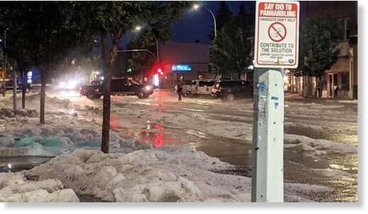
A "river of ice" - Cardston in Alberta hit with brief but intense hail storm -- Earth Changes -- Sott.net

A "river of ice" - Cardston in Alberta hit with brief but intense hail storm

David Opinko
Lethbridgenewsnow.com
Tue, 06 Jul 2021 18:23 UTC

hail
Residents and business owners in Cardston are dealing with the aftermath of a severe hail storm.

Public Works Foreman at the Town of Cardston LeNark Duce says the first hailstone dropped around 8:00 pm and, thankfully, the storm only lasted about 20 minutes.

"The hail knocked so much debris into the streets and the water was rushing - it plugged all the storm drains and so they couldn't even start to keep up. It was so much water to start with that it would've been hard to keep up with anyways."

Water and hail flowed throughout the town, flooding numerous homes and businesses.

View: https://youtu.be/_96TfcLMKl0
Run time is 3:03

Another town employee described the scene along Main Street as a "river of ice."

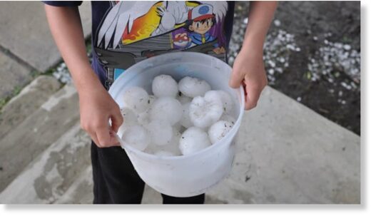
Duce said the hail was pea-sized. At the time that we spoke to him, he had yet to see any significant damages to the exteriors of buildings or vehicles.

Crops and gardens throughout the community were heavily impacted.

Other areas outside of Cardston, such as Hillspring, reportedly had larger chunks of hail.

hail

The good news, says Duce, is that the storm was short-lived, and if it had gone on for much longer, there would have been significant issues to deal with.

"Things were maxed out, but as far as I know, everything was able to keep things from being a disaster, but it was close because we had all the pumps going and it was still kind of maxed out."

He adds that things in the town have improved now but there are still several snowbanks and property owners are trying to manage any flooding.
 

TxGal

Day by day
Dear God in Heaven help us if we have another winter like last winter in Texas. This is related to the Electroverse article on La Nina above.

From KBTX in Bryan/College Station, Meteorologist Shel Winkley:

View: https://twitter.com/KBTXShel/status/1413521914518200322

From the link in Shel's twitter post:

July 2021 ENSO update: La Niña Watch | NOAA Climate.gov

July 2021 ENSO update: La Niña Watch
Author: Tom Di Liberto
July 8, 2021

As things stand with the El Niño-Southern Oscillation (ENSO), neutral conditions are currently present in the tropical Pacific and favored to last through the North American summer and into the fall. But forecasters at NOAA’s Climate Prediction Center have issued a La Niña Watch, which means they see La Niña likely emerging (~55%) during the September-November period and lasting through winter.

Pacific Ocean, June sea surface temperature anomaly

June 2021 sea surface temperature departure from the 1991-2020 average. Image from Data Snapshots on Climate.gov.

Where we are:

I know you’re all excited for me to talk about La Niña, but I’m a killjoy, so bear with me for a second while I talk about the current state of the Pacific. In June, ocean surface temperatures were near the 1991-2020 average across the equatorial Pacific, including the all-important Nino3.4 region (check out this post for more on ENSO indices), which we use to monitor the state of ENSO. Specifically, the June sea surface temperature in the Nino3.4 region was 0.25 degrees Celsius below average, well within the ENSO-neutral range. Ocean temperatures in this region have been quickly returning to near-average conditions over the last several months, increasing by nearly half a degree Celsius since April and over a degree Celsius since last winter’s La Niña peak.

But as we have said, so many, many times: there is more to ENSO than just the surface of the ocean. Putting on our snorkels, let’s dive beneath the surface of the Pacific, where things aren’t as near average but still firmly indicative of an ENSO stuck in neutral. Waters were slightly warmer than average, except for the eastern Pacific where cooler-than-average waters developed near the thermocline—the layer of water that marks the transition between the warmer upper ocean and colder deeper ocean. But overall, nothing to write home about.

To finish off this trilogy of signs about our current ENSO-neutral Pacific, we look to the skies! After all, ENSO is a coupled atmosphere/ocean climate phenomenon. And for the past month, that atmosphere has been pretty darn neutral. Winds at both low and high levels of the atmosphere were pretty normal, and while thunderstorm activity was reduced near the dateline, things were mostly average elsewhere.

There hasn’t been a more boring trilogy since Star Wars episodes 1-3 (yeah…I said it). But then again, that’s expected during neutral ENSO conditions across the Pacific.

CPC IRI ENSO outlook July 2021

The official CPC/IRI ENSO probability forecast, based on a consensus of CPC and IRI forecasters. It is updated during the first half of the month, in association with the official CPC/IRI ENSO Diagnostic Discussion. It is based on observational and predictive information from early in the month and from the previous month. Image from IRI

Where we’re going:

It might seem odd, then, with things seeming so… blah… that a La Niña Watch has been issued. To clarify, a La Niña Watch means conditions are favorable for the development of La Niña within the next six months. So, what’s in the climate model “tea leaves” that has helped scientists feel comfortable enough to start throwing the La Niña label around?

The answer, in part, lies in a strong computer model consensus. While most of the models we look at predict ENSO-neutral to continue to last through fall, many models from the North American Multi-Model Ensemble (NMME) favor a transition to La Niña during the fall and into winter. The NMME is incredibly helpful to forecasters in predicting the future state of ENSO, especially when we are past the notorious spring barrier, a time when model accuracy wanes.

ENSO Nino3.4 values, La Nina

Monthly sea surface temperature anomalies (difference from average) in the Niño 3.4 region of the tropical Pacific for 2020-21 (purple line) and all other years starting from first-year La Niña winters since 1950. Climate.gov graph based on ERSSTv5 temperature data.

Where’s the beef?

Is it all that unusual to have two La Niña winters back-to-back? Nope! In fact, of the twelve first-year La Niña events, eight (!) were followed by La Niña the next winter, two by neutral, and two by El Niño. Honestly, with those numbers, it would have been more surprising if we thought neutral conditions would continue all year.

Putting all of those 12 first-year La Niñas together with 2020-2021, it’s evident how much this last year doesn’t stand out. Though, twelve past cases are not a ton to rely on by itself. This La Niña Watch is buoyed by much more than that.

One specific reason why and when any change to ENSO is important is the potential influence on the Atlantic and eastern Pacific hurricane season. As noted on the ENSO Blog in the past, La Niña can help make atmospheric conditions more conducive for tropical cyclones to form the Atlantic, and less conducive in the Eastern Pacific. If 2021 so far is any indicator, it could be an active year: through the beginning of July, five named storms in the Atlantic have already formed, a new record—breaking the previous record set just last year. In August, the Climate Prediction Center will issue an updated hurricane outlook, so stay tuned for more info on that. In the meantime, you can read the outlook from May to see what scientists were thinking two months ago.
 

WisconsinGardener

Loony Member
I’m sure it’s in this long thread somewhere, but how does the super heat (my son-in-law was called into central British Columbia for a medovac, and it was 50C) fit in with the Grand Solar Minimum?
 

BenIan

Veteran Member
I’m sure it’s in this long thread somewhere, but how does the super heat (my son-in-law was called into central British Columbia for a medovac, and it was 50C) fit in with the Grand Solar Minimum?
Meridional jet stream, if you google it should pull up some good maps that will make it clear.
 

TxGal

Day by day
Meridional jet stream, if you google it should pull up some good maps that will make it clear.

Yep! That darn meridional flow is what also brought the arctic fronts down into Texas and Mexico in February. I'm really starting to get more worried about the upcoming winter. We're in the 70s today with rain...we're normally in drought conditions this time of year with temps in the upper 90s+.
 

TxGal

Day by day
Ice Age Farmer has a new podcast out this morning. While not directly GSM info, it has important info for water preps and gardening:

Water: Making the Most of It - Growing in the Mega Drought - YouTube

Water: Making the Most of It - Growing in the Mega Drought
22,571 views
Premiered 18 hours ago

View: https://youtu.be/X-sCn2f8jeI
Run time is 50:15

Synopsis provided:

As irrigation districts and municipal suppliers cut water allocations in the 'mega drought,' we must use strategies to maximize our use of each drop. In this talk, Christian introduces concepts from rainwater harvesting, greywater systems, sunken beds and earthworks, soil infiltration/holding, creating shade to minimize evaporation, and drought tolerant varieties that will help anyone, anywhere to create a maximum of yield even given a restrictive water budget.
 

TxGal

Day by day
The Oppenheimer Ranch Project has a new podcast out, another volanco eruption:

Spectacular Lava Fountaining At Etna Volcano - Strongest Paroxysm - Ash To 11km (36,000ft) - Uptick - YouTube

Spectacular Lava Fountaining At Etna Volcano - Strongest Paroxysm - Ash To 11km (36,000ft) - Uptick
4,644 views
Premiered 19 hours ago

View: https://youtu.be/oST57ePi_ls
Run time is 5:30

Synopsis provided:

Etna volcano update: Powerful lava fountain during night 8-9 July 2021, ash plume to 11 km altitude https://bit.ly/36oZq7s
Etna Volcano Volcanic Ash Advisory: ERUPTION AT 20210708/2021Z LAVA FOUNTAIN IS OBSERVED OBS VA DTG: 09/0300Z https://bit.ly/2TSZEBi
Etna's Eruptive History https://s.si.edu/2KP1qz0
Spectacular View Of Eruption Of Lava From Mount Etna In Sicily Lights Up Night Sky
https://bit.ly/2TSsnpT
 

TxGal

Day by day
Record Lows Logged in Sydney, as Upper Michigan suffers a rare Summer Freeze, + Two Solar Flares, Two Radio Blackouts (electroverse.net)

blackoutmap2-e1625906779804.png

Articles Extreme Weather GSM

RECORD LOWS LOGGED IN SYDNEY, AS UPPER MICHIGAN SUFFERS A RARE SUMMER FREEZE, + TWO SOLAR FLARES, TWO RADIO BLACKOUTS
JULY 10, 2021 CAP ALLON

Sydney, Australia has just shivered through its coldest July day in a decade after maximum temperatures struggled to just 12.1C (53.8F) on Friday afternoon.

That Friday high of 12.1C (53.8F) was Sydney’s coldest July maximum since 2011 (solar minimum of cycle 24).

wolfaml2-1.png

[sidc.be/silso]

Another cold day is expected Saturday as strong southerly winds whipped-up from Antarctica hold temperatures at similar lows; however, showers will start to break up by Saturday afternoon as the trough moves offshore, and readings around 12C are unlikely to be repeated in the New South Wales (NSW) capital.

Sydney’s record cold comes after a particularly icy week for the state of NSW, as well as for the entire Australian continent as whole — every state and territory managed to register temperatures cold enough for frost, and all but one saw the mercury plunge below -2C (28.4F), reports 9news.com.au.

The reason for the frigid mornings was string of high pressure systems kicked-up from the polar regions.

These caused a combination of clear skies, light winds and extremely cold, dry air — the ideal ingredients for frost-producing lows at this time of year.

Perisher in the NSW snowy mountains recorded Australia’s first -10C (14F) of the year, while Alice Springs woke to sub-zero temperatures twice in one week, a very rare occurrence.

Further chills are to be forecast across the Australian continent over the weekend.

Stay tuned for updates.

UPPER MICHIGAN SUFFERS A RARE SUMMER FREEZE

Several locations in Upper Michigan suffered a rare summer freeze on Friday, July 9.

The mercury struggled to 31F (-0.6C) yesterday morning at Baraga Plains, Doe Lake and Stonington “in the 2nd week of July!”, exclaimed a recent woodtv.com article.

With dry air (low dewpoint) and a polar breeze, the temperature managed to plummet across the UP, even with the relatively short nights of mid-summer.

For many locales, the overnight drop was stark — in Stonington, for example, the high on Thursday touched 74F (23.3C), but that 31F (-0.6C) low logged by Friday morning meant the city suffered a whopping 43F (23.9C) temperature drop — another example of the increased swings between extremes we experience during times of low solar activity.

While not a freeze, the mercury did dip into the 30s across a significant portion of the U.P.

Low temperatures included 38F at Ironwood and 39F at Marquette (airport) — all record lows for the time of year.

And looking ahead, many parts of the CONUS can expected further summer chills in the days and weeks ahead:


Additionally, check out the ‘global cooling accelerator’ just announced by NOAA:


TWO SOLAR FLARES, TWO RADIO BLACKOUTS

Departing sunspot AR2840 erupted twice on July 9, producing a pair of almost-M-class solar flares.

NASA’s Solar Dynamics Observatory captured the two ultraviolet flashes:


Pulses of X-radiation ionized the top of Earth’s atmosphere.

The result, according to Dr Tony Phillips of spaceweather.com, were two radio blackouts, one over Asia:


And another over Europe:


In addition, mariners, aviators, and ham radio operators may have noticed unusual propagation effects at frequencies below ~15 MHz.

Once again, this event wasn’t expected and serves as yet another ‘warning shot’, cementing the disturbing reality that even minor solar flarings are having a bigger and bigger impact on our planet’s ever-waning magnetosphere, as the magnetic poles continue to shift.

For more on that, click the link below:


Enjoy your weekend!

I’m off out to plant my second corn crop of the season.

I grow the heirloom variety “Golden Bantam”.

Here in rural Portugal I’m working for a life detached from the ‘modern slave model’ and away from the ‘authoritative rule’ of those faceless elites.

If you’re interested in striving for the same (I don’t know why you wouldn’t be), and you’re new to growing your own, then here (linked below) may be a useful place to start:


The COLD TIMES are returning, the mid-latitudes are REFREEZING, in line with the great conjunction, historically low solar activity, cloud-nucleating Cosmic Rays, and a meridional jet stream flow (among other forcings).

Both NOAA and NASA appear to agree, if you read between the lines, with NOAA saying we’re entering a ‘full-blown’ Grand Solar Minimum in the late-2020s, and NASA seeing this upcoming solar cycle (25) as “the weakest of the past 200 years”, with the agency correlating previous solar shutdowns to prolonged periods of global cooling here.

Furthermore, we can’t ignore the slew of new scientific papers stating the immense impact The Beaufort Gyre could have on the Gulf Stream, and therefore the climate overall.


Prepare accordinglylearn the facts, relocate if need be, and grow your own.
 

TxGal

Day by day
Last edited:

TxGal

Day by day
Extreme Cold and Heavy Snow to smash South Africa, + 'The Year Without a Summer', by John Maunder (electroverse.net)


SA-chill-e1626078490333.jpg

Articles Crop Loss Extreme Weather GSM

EXTREME COLD AND HEAVY SNOW TO SMASH SOUTH AFRICA, + ‘THE YEAR WITHOUT A SUMMER’, BY JOHN MAUNDER
JULY 12, 2021 CAP ALLON

Another major Antarctic front will make landfall in Southern Africa today, Monday, July 12 — gale force winds, extreme cold, heavy snow, high waves, and torrential rains are ALL in the forecast.

It will be very cold in the Western and Northern Cape this week, warned the South African Weather Service (SAWS) on Sunday.

Snow as deep as 20cm (8 inches) is forecast to accumulate along the western mountains of the Western Cape, and SAWS has issued a rare ‘Level 4’ snowfall warning as a result — “Blimey, it’s not often we see one of these,” is how thesouthafrican.com puts it.

Power utility company Eskom has urged South African’s to reduce electricity usage during the big freeze.

The company has also warned that ‘load-shedding’ is likely, writing in a statement: “The cold front will increase the demand for electricity thereby putting pressure on the power system.”

View: https://twitter.com/Eskom_SA/status/1414471278094864384

The SA Weather Service has told farmers and growers to brace for significant livestock and crop losses.

“This is going to bring lots of very cold weather,” said Government spokesperson, James-Brent Styan.

“In the rural areas we want to caution people about the cold weather that can be expected, (which) poses a risk to people being outdoors as well as vulnerable livestock,” continued Styan, speaking to sabcnews.com.

View: https://twitter.com/SAWeatherServic/status/1414112598484791297

The cold front will enter Cape Town on Monday morning.

It will deliver strong winds from Cape Colombine to Cape Agulhas, reports sowetanlive.co.za, with infrastructure damage along the Western Cape coastline likely.

By Tuesday, July 12, extreme temperature anomalies of as much as 20C below the seasonal norm will have engulfed South Africa, Botswana, Namibia:


GFS 2m Temperature Anomalies (C) for Tues, July 12 [tropicaltidbits.com].

Theses “blues” and “purples” will gain further territory northward as the week progresses — into Mozambique, Zimbabwe, Zambia, and Angola by Wednesday, July 14.

View: https://twitter.com/SAWeatherServic/status/1414114974495092736

SA meteorologists Wayne Venter and Kate Turner expect the polar blast to persist in the Northern, Eastern, and Western Cape throughout the week, with widespread frost forecast Wednesday through Friday.

The forecasters warned of rain leading to flooding in Cape Town, Drakenstein and Stellenbosch.

While rare level 4 snowfall warnings have also been issued for both Monday and Tuesday, most notably in Namakwa, in the Northern Cape, as well in Cederberg, Witzenberg and Breede Valley, in the Western Cape.

Garden Route should expect heavy snow totals on Tuesday afternoon.

LOOKING FURTHER AHEAD

The models are suggesting another extreme cold front will batter the region later in the month.

This one threatens to be even more intense than the first, and, as it stands, is on course to send the mercury across eastern South Africa and southern Mozambique some 22C below the winter norm.

It has the potential to deliver record cold to the region, and further debilitating snowfall.


GFS 2m Temperature Anomalies (C) for Weds, July 21 [tropicaltidbits.com].


GFS 2m Temperature Anomalies (C) for Thurs, July 22 [tropicaltidbits.com].

An anomalously cold Antarctica has been firing numerous icy shots over Southern Hemisphere land masses in recent weeks — from South America to Australia, and from Southern Africa to New Zealand, wave after wave of powerful polar air masses have been engulfing the lower latitudes:


A unusually cold Antarctica has also seen the continent’s sea ice extent track well-above the 1979-1990 average this year, with the latest data point –from July 10 (or day 191)– actually accelerating that growth, to 15.707 million km2:


[NSIDC]

Stay tuned for updates.

THE YEAR WITHOUT A SUMMER, BY JOHN MAUNDER

Some of the answers to the complexities of the climate system are given John Maunder’s recently published book Fifteen shades of climate… the fall of the weather dice and the butterfly effect.

The following are extracts from pages 203- 207
:

The 19th Century weather disaster – dubbed “The Year Without a Summer” – happened in 1816, when the weather in Europe and North America took a bizarre turn which resulted in widespread crop failures and famine.

On April 10, 1815, Mount Tambora in Indonesia produced the largest eruption known on the planet during the last 10,000 years. The volcano erupted more than 50 cubic kilometres of magma. The eruption produced global climatic effects and killed more than 100,000 people, directly and indirectly. Pyroclastic flows reached the sea on all sides of the peninsula, and heavy tephra fall devastated croplands, causing an estimated 60,000 fatalities. Entire villages were buried under thick pumice deposits. Some of the settlements have recently been brought back to light by archaeological excavations, making a site called ‘Pompeii of Indonesia’. While the death toll of people living on Sumbawa and surrounding coastal areas was high enough, even more fatalities can be attributed to an indirect effect of global climate deterioration after the eruption.

These changes turned 1816 into ‘The Year without a Summer’ for much of Europe, causing widespread famine. The reason for the climatic changes was increased absorption of sunlight due to a veil of aerosols dispersed around both hemispheres by stratospheric currents from the tall eruption column. Global temperatures dropped by as much as 3°C in 1816.

UNPRECEDENTED WEATHER IN 1816

‘The Year without a Summer’ was well reported in the United States and Europe, as the following description suggests.

The weather in 1816 was unprecedented. Spring arrived but then everything seemed to turn backward, as cold temperatures returned. The sky seemed permanently overcast. The lack of sunlight became so severe farmers lost their crops and food shortages were reported in Ireland, France, England, and the United States. In Virginia, Thomas Jefferson retired from the presidency and farming at Monticello sustained crop failures that sent him further into debt.

It would be more than a century before anyone understood the reason for the peculiar weather disaster: the eruption of an enormous volcano on a remote island in the Indian Ocean one year earlier had thrown enormous amounts of volcanic ash into the upper atmosphere.

But before the cause was known, in Switzerland, the damp and dismal summer of 1816 led to the creation of a significant literary work. A group of writers, including Lord Byron, Percy Bysshe Shelley, and his future wife, challenged each other to write dark tales inspired by the gloomy and chilly weather. During the miserable weather Mary Shelley wrote her classic novel Frankenstein.

The Albany Advertiser went on to propose some theories about why the weather was so bizarre.

The mention of sunspots is interesting, as sunspots had been seen by astronomers. What’s fascinating is the newspaper article from 1816 proposes such events should be studied, so people can learn what is going on. For example:

“Many seem disposed to charge the peculiarities of the season, the present year, upon the spots on the sun. If the dryness of the season has in any measure depended on the latter cause, it has not operated uniformly in different places – the spots have been visible in Europe, as well as in the United States and yet in some parts of Europe, as we have already remarked, they have been drenched with rain.”

“Without undertaking to discuss, much less to decide, such a learned subject as this, we should be glad if proper pains were taken to ascertain, by regular journals of the weather from year to year, the state of the seasons in this country and Europe, as well as the general state of health in both quarters of the globe. We think the facts might be collected, and the comparison made, without much difficulty; and when once made, that it would be of great advantage to medical men, and medical science.”

VOLCANIC HAZARDS

Today, in 2021, we now know volcanoes can pose many hazards. One hazard is that volcanic ash can be a threat to jet aircraft where ash particles can be melted by the high operating temperature. The melted particles then adhere to the turbine blades and alter their shape, disrupting the operation of the turbine.

Large volcanic eruptions can affect temperature, as ash and droplets of sulphuric acid obscure the sun and cool the Earth’s lower atmosphere, or troposphere. However, they also absorb heat radiated up from the Earth, thereby warming the upper atmosphere, or stratosphere. Historically, socalled volcanic winters have caused catastrophic famines.

From Wood, Gillen D’Arcy, ‘1816, The Year without a Summer’. Britain, Representation and Nineteenth-Century History. Ed. Dino Franco Felluga. Extension of Romanticism and Victorianism on the Net, we read the following:

“To be alive in the years 1816-18, almost anywhere in the world, meant to be hungry. Across the globe during the so-called ‘Year without a Summer’ – which was, in fact, a three-year climate crisis – harvests perished in frost and drought or were washed away by flooding rains. Villagers in Vermont survived on hedgehogs and boiled nettles, while the peasants of Yunnan in China sucked on white clay. Summer tourists travelling in France mistook beggars crowding the roads for armies on the march.”

“Famine-friendly diseases cholera and typhus stalked the globe from India to Italy, while the price of bread and rice, the world’s staple foods, skyrocketed with no relief in sight. Across a European continent devastated by the Napoleonic wars, tens of thousands of unemployed veterans found themselves unable to feed their families. They gave vent to their desperation in town square riots and military-style campaigns of arson, while governments everywhere feared revolution. In New England, 1816 was nicknamed ‘Eighteen-Hundred-and-Froze-to-Death’ while Germans called 1817 ‘The Year of the Beggar’. ”

“In the scientific literature, the 1816’s cold summer was the most significant meteorological event of the nineteenth century. The global climate emergency period of 1816-18, as a whole, offers us a clear window onto a world convulsed by weather anomalies, with human communities everywhere struggling to adapt to sudden, radical shifts in weather patterns, and to a consequent tsunami of famine, disease, dislocation and unrest.”

SURPRISE AURORAS

There were no auroras in the forecast on July 10.

Then, unexpectedly, a ‘crack’ opened in Earth’s magnetic field.

This allowed solar wind to rush in and fuel this impressive display:


[MaryBeth Kiczenski July 10, 2021]

The image was captured by MaryBeth Kiczenski while on a boat just off Pictured Rocks National Lakeshore in Michigan’s Upper Peninsula — and it again hints at our planet’s ever-waning magnetosphere as its magnetic poles continue their excursion.

Click the below article for more on that:


The COLD TIMES are returning, the mid-latitudes are REFREEZING, in line with the great conjunction, historically low solar activity, cloud-nucleating Cosmic Rays, and a meridional jet stream flow (among other forcings).

Both NOAA and NASA appear to agree, if you read between the lines, with NOAA saying we’re entering a ‘full-blown’ Grand Solar Minimum in the late-2020s, and NASA seeing this upcoming solar cycle (25) as “the weakest of the past 200 years”, with the agency correlating previous solar shutdowns to prolonged periods of global cooling here.

Furthermore, we can’t ignore the slew of new scientific papers stating the immense impact The Beaufort Gyre could have on the Gulf Stream, and therefore the climate overall.


Prepare accordinglylearn the facts, relocate if need be, and grow your own.
 

TxGal

Day by day
The Oppenheimer Ranch has a new podcast out:

Heat Wave Roasts the West, Wildfires Explode in Size, Hail! - Relief Is Coming - BEAM Soil Inoculant - YouTube

Heat Wave Roasts the West, Wildfires Explode in Size, Hail! - Relief Is Coming - BEAM Soil Inoculant
4,090 views
Premiered 8 hours ago

View: https://youtu.be/o2jGuLd-Mrk
Run time is 15:34

Synopsis provided:

Heat wave roasts the West as wildfires explode in size https://bit.ly/3k902WX
Smoke Forecast https://bit.ly/3eehcil
Insurance companies prepare for thousands of claims after hail storm https://bit.ly/3AOXzH8
Large hail batters Des Moines metro area https://bit.ly/3kbCLUz
Hail pelts Alliance, Nebraska weather service warns of 'baseball-sized' hail https://bit.ly/3hYfans
Parts of Prescott hit with wind, rain, and even golf ball-sized hail https://bit.ly/2Tc9HkI
30% of Mt Rainier's snowpack melted off during historic heatwave https://bit.ly/3i5XF4v
A Break in Western Heat Coming; Storms and Heavy Rain SW to NE https://www.weather.gov/
GFS Model Total Precipitation US https://bit.ly/2VqesHV
UCLA study shows human influence on heavy rain, snow since 1980s https://bit.ly/2T4tTVq
Anthropogenic influence on extreme precipitation over global land areas seen in multiple observational datasets https://go.nature.com/2UD3a2K
Cosmic Rays Since 1950 https://bit.ly/3r6Y8b5
Cosmic Rays vs Temperature Since 1850 https://bit.ly/3r6Y4bl
Cosmic Ray Modern Maximum https://bit.ly/3kfM82Y
Surface Conditions Greenland http://bit.ly/2KXO5DF
Record-breaking night temperatures: What can America's extreme weather tell us about climate change https://bit.ly/3kcLiq0
Extreme Weather Keeps Maxing Out the Grid https://bit.ly/3xCMozq
Mt Ruapehu status update: new heating phase starts at the crater lake (Te Wai ā-moe) https://bit.ly/2U3ogHE
500,000 residents to evacuate if ‘violent eruption’ occurs in Taal Volcano https://bit.ly/3hCr33D
Worldwide Volcano News and Updates https://bit.ly/3y58XgJ
How the highly unusual Death Valley temperatures just got more complicated https://cnn.it/3i7J88N
Fox News’ planned 24-hour weather channel has climate experts worried https://bit.ly/3i6tpXg
Undersea volcanoes are home to more life than we know https://bit.ly/3hAmR4b
 

TxGal

Day by day
Natural Gas Prices Skyrocket GLOBALLY due to Historically Cold 2021 and Failing Renewables (electroverse.net)

LNG-3-e1626164844149.jpg

Articles Extreme Weather GSM

NATURAL GAS PRICES SKYROCKET GLOBALLY DUE TO HISTORICALLY COLD 2021 AND FAILING RENEWABLES
JULY 13, 2021 CAP ALLON

A surge in natural gas prices on the global market has emerged.

The market has been in upheaval in recent months due to a rapid depletion of supplies in Asia and Europe due to the historically cold winter of 2020-2021 and the big freezes which extended well-into spring.

This is according to Sohbet Karbuz, of Bilkent University Energy Policy Research Center, who also attributes the increased LNG prices to a rise in carbon prices in Europe, and to natural gas having to fill the void created by the lower-than-expected generation from renewables.

In other words, this issue is partly self-inflicted as ‘green policy’ continues to hamstring the global energy supply.

“The prices were around $25 per ton in November 2020, now it’s over $50,” laments Karbuz. “As such, the transition from coal to gas accelerated. Wind and solar also failed to deliver what was expected in electricity generation in Europe,” he adds.


The gas market in Asia has changed over the past six months, explains Karbuz, with China overtaking Japan as the world’s largest LNG importer.

Karbuz warns that Japan’s demand will increase with the start of the Tokyo Olympics –due to begin on July 23– and that this will heap further pressures on the market by creating even greater competition among importers.

Karbuz also notes that the LNG market pivoting away from Europe to focus on Asia has resulted in much higher prices across the EU.

“Europe is in a difficult situation in terms of price,” he says. “LNG prices are increasing. There has been a decrease in LNG input capacity due to maintenance and malfunctions in some LNG facilities in Europe, which is considered as the last supplier.”

The shortage in gas supplies has been compounded by Russia’s reluctance to exceed its normal contract with supplies to Europe.

“Russia sends gas almost at full capacity from Yamal (liquefied natural gas terminal) and through the Nord Stream (gas pipeline). It could increase the flow through Ukraine, but it does not want to exceed the normal contract amount. There is a geopolitical war,” says Karbuz.

Successive problems with gas imports from Libya to Italy in June have further contributed to the shortage.

Rethinking Future Investments in Natural Gas Infrastructure | Greentech  Media

As of the end of June, gas stocks in Europe dropped to the lowest level in the past 10 years, culminating in near seven-fold price increases.

Prices at the UK’s National Balancing Point (NBP) hub, the Dutch Title Transfer Facility (TTF) and the Japan Korea Marker (JKM) were below $2 per MMBtu (Metric Milion British Thermal Unit) in June 2020; but now, as of July 7, prices have soared to $10.92 on the NBP, $11.19 on the TTF, and $12.69 on the JKM.

It is feared that this won’t bode well for winter prices when demand is at its highest yet supply is low.

“If the weather is bad and there is not enough gas in the tanks, then there will be a big turmoil in gas prices,” concludes Karbuz — people could wind-up struggling through the harshest months of the year without energy.

Unfortunately, a cold winter is exactly what’s expected, particularly given the reemergence of La Niña conditions:


It may be the middle of summer, but those in the Northern Hemisphere should be preparing for winter NOW as a myriad of miseries threaten to combine and hit simultaneously — the perfect stormthe Grand Solar Minimum.

Don’t rely on a fragile infrastructure or on the planning of local government — they will fail you.

Be the ant, not the grasshopper.

Be responsible for yourself.

The COLD TIMES are returning, the mid-latitudes are REFREEZING, in line with the great conjunction, historically low solar activity, cloud-nucleating Cosmic Rays, and a meridional jet stream flow (among other forcings).

Both NOAA and NASA appear to agree, if you read between the lines, with NOAA saying we’re entering a ‘full-blown’ Grand Solar Minimum in the late-2020s, and NASA seeing this upcoming solar cycle (25) as “the weakest of the past 200 years”, with the agency correlating previous solar shutdowns to prolonged periods of global cooling here.

Furthermore, we can’t ignore the slew of new scientific papers stating the immense impact The Beaufort Gyre could have on the Gulf Stream, and therefore the climate overall.


Prepare accordinglylearn the facts, relocate if need be, and grow your own.
 

TxGal

Day by day
The Tropics just logged its Second-Coldest Temperature in History, as ALL-TIME Record Cold sweeps South America - Electroverse

Chaco-cold-e1626172650211.jpg

Extreme Weather GSM

THE TROPICS JUST LOGGED ITS SECOND-COLDEST TEMPERATURE IN HISTORY, AS ALL-TIME RECORD COLD SWEEPS SOUTH AMERICA
JULY 13, 2021 CAP ALLON

It’s been a historically chilly first half of the year for many locales –despite what the obfuscating mainstream media prints and bleats– and it is a fact that the global average temperature has regularly dipped below the 30-year baseline in 2021: in March, April, and June (click HERE for more on that).

And now comes the news that the Tropics has just logged one of its coldest temperatures ever recorded.

The reading comes from South America — a continent that has been suffering record-breaking lows and snows in recent weeks:


The Chaco Region (or Región Occidental) is a semi-arid region in Paraguay, known for its weather extremes.

The mercury can easily climb to 100F as well as tumble below the freezing mark.

1. Map of Paraguay showing the three general regions and the Ecoregions...  | Download Scientific Diagram
The regions of Paraguay (Chaco located in the north).

A few days ago, Chaco logged a historic -7.4C (18.7F).

This was the second-lowest temperature ever recorded at such low elevations in the tropics, worldwide.

It also adds to the numerous ALL-TIME cold records busted across the South American continent of late.

Staying in Paraguay, a few of the benchmarks to have fallen recently include 1) the -5.4C (22.3F) registered in Nueva Asuncion–which busted the region’s previous all-time low temperature record of -5C (23F) set on July 18, 1975 (solar minimum of cycle 20), and 2) the -2.8C (27F) observed in Base Aerea Jara–which smashed the old all-time record of -1.4C (29.5F) from June 29, 1996 (solar minimum of cycle 22).

Additionally, Paraguay recently experienced its coldest-ever June temperature — a bone-chilling low of -7.3C (18.9F) was recorded at Pozo Hondo at the close of last month (although some sources have the record-breaker as the -7.5C (18.5F) at Pratt Gill; but regardless, a new all-time June low was set).

Crossing Paraguay’s NE border, and into Bolivia, never-before seen lows have been logged here, too.

These include, but are not limited to, 1) San Jose de Chiquitos’ reading of -1C (30.2F)–which comfortably usurped the +0.3C (32.5F) set back in May, 1949 and also brought with it the first-ever frost to the town, and 2) Ascension de Guarayos’ +1.2C–which annihilated the town’s previous all-time low of +4C (39.2F) from August, 1985 (solar minimum of cycle 21).

And note that ALL of the weather stations above are AWSs, and are part of the DMH net of automatic stations — so there is no questioning their reliability (no more so than with any other official recognized station, that is).

The mainstream media refuses to acknowledge the record-breaking negative anomalies currently sweeping vast swathes of the planet as it continues to push its AGW propaganda on a criminally ill-informed public.

The facts are the facts, and during the peak of what the MSM would have you believe was a catastrophic and all-encompassing heatwave in the Pacific Northeast, global temperatures actually fell in June, 2021, to below the 30-year average:


This is an impossibility under the global warming theory.

The theory needs demoting to the status of hypothesis–or better yet, its needs rejecting altogether.

Human carbon dioxide emissions have continued their upward trend in recent years, but global temperatures haven’t — on the contrary in fact, temps have fallen dramatically —down some 0.7C since the start of 2016— and no letup to this downward trend is in sight, particularly given the historically low solar activity we’ve receiving coupled with the ‘global cooling accelerator’ recently announced by NOAA, expected to arrive in the fall:


Prepare — grow your own.

The COLD TIMES are returning, the mid-latitudes are REFREEZING, in line with the great conjunction, historically low solar activity, cloud-nucleating Cosmic Rays, and a meridional jet stream flow (among other forcings).

Both NOAA and NASA appear to agree, if you read between the lines, with NOAA saying we’re entering a ‘full-blown’ Grand Solar Minimum in the late-2020s, and NASA seeing this upcoming solar cycle (25) as “the weakest of the past 200 years”, with the agency correlating previous solar shutdowns to prolonged periods of global cooling here.

Furthermore, we can’t ignore the slew of new scientific papers stating the immense impact The Beaufort Gyre could have on the Gulf Stream, and therefore the climate overall.


Prepare accordinglylearn the facts, relocate if need be, and grow your own.
 

TxGal

Day by day
The US experienced 8 billion-dollar weather and climate disasters in the first six months of 2021 -- Earth Changes -- Sott.net

The US experienced 8 billion-dollar weather and climate disasters in the first six months of 2021


ncei.noaa.gov
Fri, 09 Jul 2021 07:23 UTC

Billion dollar US weather events 2021
  • The eight individual billion-dollar events of 2021 include: two flood events focused in California (January 24-29) and Louisiana (May 14-19); the historic mid-February winter storm and cold wave with impacts focused in Texas; two severe storm events in late-March (24-25 and 27-28) across many southeastern and eastern states, respectively; two severe storm events focused across Texas and Oklahoma in mid-to-late April (12-15 and 27-28); and the expanding Western drought and heatwave that has amplified throughout 2021.
  • In addition to significant economic impacts, the eight events identified during the first half of 2021 resulted in at least 331 fatalities.
  • The most costly U.S. event so far in 2021 was the February 10-19 Winter Storm and Cold Wave with total, direct losses of approximately $20 billion. This is now the most costly U.S. winter storm event on record surpassing (nearly doubling the inflation-adjusted cost of) Superstorm 1993.
  • The January-June 2021 inflation-adjusted costs are at a near-record pace for the first six months, at nearly $30 billion — trailing only 2011.
  • Since these billion-dollar disaster records began in 1980, the U.S. has sustained 298 separate weather and climate disasters where overall damages/costs reached or exceeded $1 billion (based on the CPI adjustment to 2021) per event. The total cost of these 298 events exceeds $1.975 trillion.
See full report here.

Comment: Last year the world was hammered by record 50 billion-dollar weather disasters.
 
Top