
You are using an out of date browser. It may not display this or other websites correctly.
You should upgrade or use an alternative browser.
You should upgrade or use an alternative browser.
Solar Grand Solar Minimum part deux
- Thread starter Dennis Olson
- Start date
-
- Tags
- grand solar minimum
jed turtle
a brother in the Lord
I do not use google.Google Northern Crown
a description would be appreciated , and I suspect, required...And perhaps a link also for each picture...
eta: and if the posts are not somehow directly related to the thread subject, one might have better posted them as a separate thread in this same sub-forum as “celestial” subject matter, unless, perhaps the articles you found them at goes into detail how whatever the pictures are about somehow complement the subject matter of Grand Solar Minimum.

TxGal
Day by day
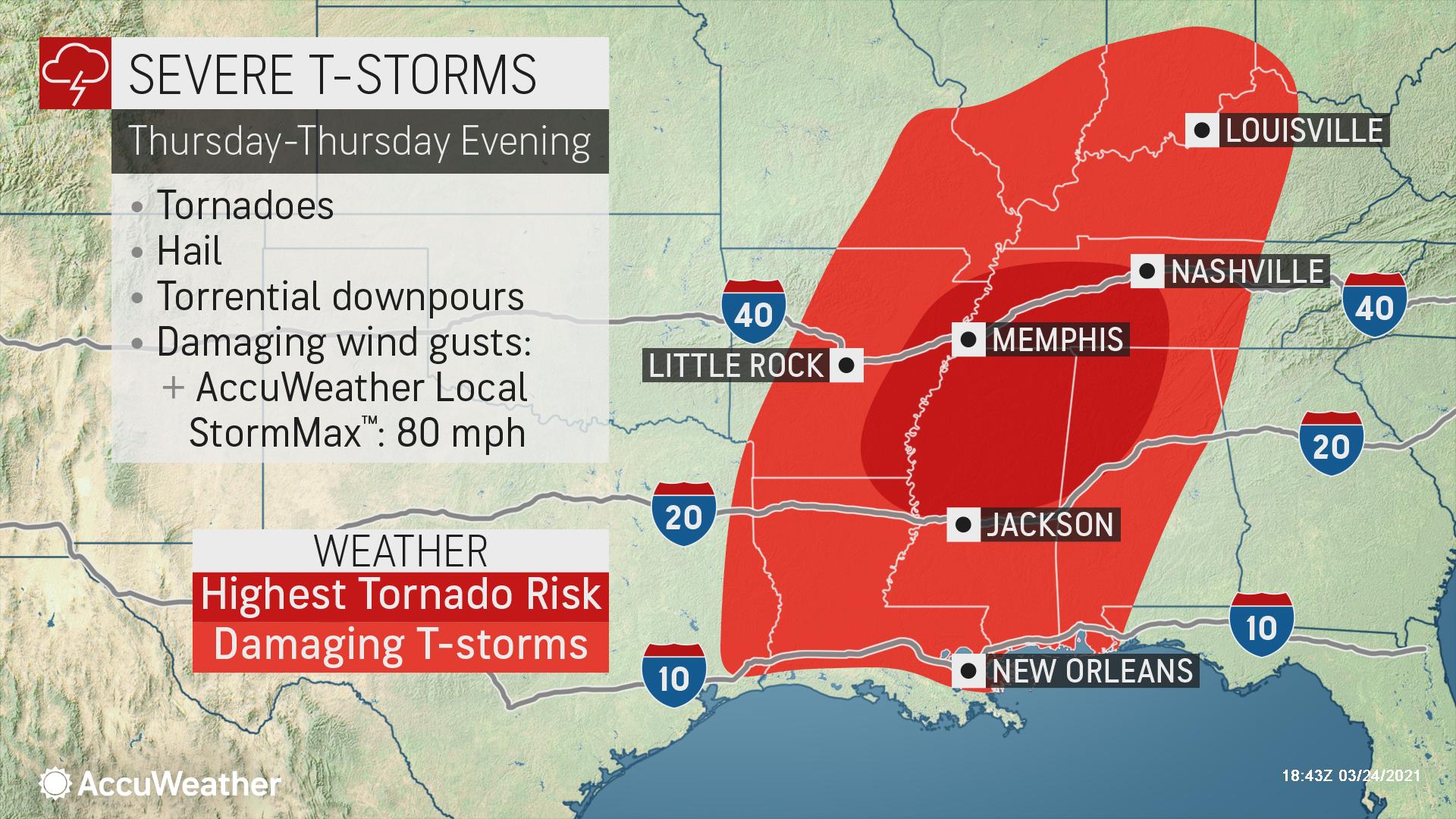
Winter Storm Killed [at least] 57 in Texas - Electroverse

WINTER STORM KILLED [AT LEAST] 57 IN TEXAS
MARCH 24, 2021 CAP ALLON
A month after a historic winter storm brought Texas’s grid to its knees, leaving 5+ million without power, preliminary data recently released by the Texas Department of State Health Services reveals a grim picture — at least 57 Texans lost their lives.
The unlucky 57 perished as a direct result of the storm, according to data.
The majority of the deaths were associated with hypothermia — in ordinary terms: “They froze to death, some in their beds, like an 11-year-old boy in Conroe,” reads a guest editorial at dentonrc.com.
Others died of carbon monoxide poisoning after burning all-sorts of outdoor appliances inside, in desperation.
Some perished because of medical equipment failure, such as when their last oxygen tank ran empty.
Others of falls.
Some of fire, as in the case of three children and their grandmother in Sugar Land — all killed in a blaze suspected to have started near the fireplace they had used to keep warm. Their mother, Jackie Nguyen, who had to be physically restrained from going back into the house to save them, described her children as “phenomenal, amazing, little badass humans.”

The Chill of Solar Minimum.
So, last month we had tens of people dying of the cold, in a U.S. state, in 2021, on a supposedly catastrophically warming planet. Something doesn’t add up–and putting Texas’s mismanaged power-grid to one side, solar activity is the overlook component here.
The Sun’s historically low activity in cycle 24 took the majority of researchers and solar physicists by complete surprise, particularly with regards to its very long minimum period between cycles 23 and 24 (more than two years in 2008–2010) in which there was a lack of any activity at all.
As discussed by Simon J. Shepherd et al. in their 2014 paper PREDICTION OF SOLAR ACTIVITY FROM SOLAR BACKGROUND MAGNETIC FIELD VARIATIONS IN CYCLES 21-23: “this minimum solar activity was evident not only in the lack of sunspots but also in solar magnetic field variations (de Toma et al. 2010a, 2010b), modulation of cosmic rays (McDonald et al. 2010), and in interplanetary coronal mass ejections (Barnard et al. 2011).”
This prolonged minimum in cycle 24 was all the more surprising because the previous five cycles had been extremely active and so sunspot-productive that they were designated as a Grand Solar MAXIMUM (Solanki et al. 2004; Usoskin 2008; Usoskin et al. 2008; Solanki & Krivova 2011).
“In cycle 24, the Grand Maximum was followed by much lower solar activity, prompting some authors to suggest that the Sun is on its way toward a Maunder Minimum of activity (Lockwood et al. 2011),” writes Shepherd. “This reduced appearance of sunspots in the current cycle 24 was not anticipated by many researchers before the cycle began but has since given birth to a slew of papers suggesting we are indeed now headed into the next Grand Solar MINIMUM.”
Simon J. Shepherd et al. concluded in 2014, with a sufficient degree of confidence, that the solar activity in cycles 24–26 will be systematically decreasing: “we predict a noticeable decrease of the average sunspot numbers in cycle 25 to ≈80% of that in cycle 24 and a decrease in cycle 26 to ≈40%”:

Modulus summary principal component (solid curve) for cycles 21–23 and predicted for cycles 24–26.
Even NOAA’s PREDICTED SUNSPOT NUMBER AND RADIO FLUX data appears to show a ‘full-blown’ Grand Solar Minimum running from the late-2020s through the 2040s (at least).
NOAA are still (as of March 24, 2021) predicting a weak Solar Cycle 25 –one comparable to SC24– with the maximum peaking at 114.6 sunspots in July, 2025. The agency then goes on to plot the descent into the minimum of SC25, which they say will start in mid-2025 and bottom out around 2031 — and while this paints SC25 as another historically weak cycle, it isn’t the story here: NOAA aren’t expecting a ramp-up into SC26! When the sunspot number should be ramping back up, the agency’s data (linked again here) reveals the number of sunspots instead continues dropping.
NOAA are predicting all-but ZERO sunspots throughout the 2030s.
There is no ramp-up into Solar Cycle 26.
In fact, there is no SC26, nor are there any signs of SC27 (due to commence around 2040):


NOAA is predicting a ‘full-blown’ Grand Solar Minimum (GSM).
GSM’s can result in zero sunspots on our Sun, for often decades at a time — the impacts this can have on Earth’s climate have been well documented throughout history: the most famous example being the Maunder Minimum (1645-1715) which saw plummeting temperatures, crop loss, famine, and the deaths of hundreds of millions of people ACROSS the planet.
Unfortunately, we modern humans will suffer something of a double-whammy this time round; because unlike those living during the Maunder Minimum, we have an additional cosmological forcing to contend with. Earth’s magnetosphere –a key line of defense against incoming radiation– is waning at an increasing rate as north and south magnetic poles continue their wander. Our magnetic field is expected to be considerably weaker by the 2030s (the onset of the GSM-proper, according to NOAA), and as with previous magnetic excursions/reversals, these events lead to an uptick in volcanic/seismic activity, solar outbursts (including CMEs), and even the onset of ice ages. These two independent factors (a GSM & a Pole Shift) occurring simultaneously is throwing us something of a curve-ball. Each factor alone leads to a dramatic waning of earth’s magnetosphere, but together they are delivering a double-whammy — the upshot will be an unprecedented level of Cosmic Rays entering our atmosphere nucleating clouds, sending volcanoes a’poppin’, dropping terrestrial temperatures, and affecting biology across the planet.
For all those out there who sense that “something is coming” ––and I believe there are many of us– the Grand Solar Minimum & Pole Shift could be that something. We humans are programmed to recognize cycles, them having been ingrained within us throughout our evolution, and the activity of the cosmos runs like clockwork.
Climate is cyclic, never linear; and after a spell of cumulatively high solar output, which brought about hundreds of years of prosperity and progress, human civilization is now reentering some very hard times.
I’m headed out to transplant a patch of Sorghum — what are you doing to prepare…?
The COLD TIMES are returning, the mid-latitudes are REFREEZING in line with the great conjunction, historically low solar activity, cloud-nucleating Cosmic Rays, and a meridional jet stream flow (among other forcings).
Both NOAA and NASA appear to agree, if you read between the lines, with NOAA saying we’re entering a ‘full-blown’ Grand Solar Minimum in the late-2020s, and NASA seeing this upcoming solar cycle (25) as “the weakest of the past 200 years”, with the agency correlating previous solar shutdowns to prolonged periods of global cooling here.
Furthermore, we can’t ignore the slew of new scientific papers stating the immense impact The Beaufort Gyre could have on the Gulf Stream, and therefore the climate overall.


Prepare accordingly— learn the facts, relocate if need be, and grow your own.
TxGal
Day by day
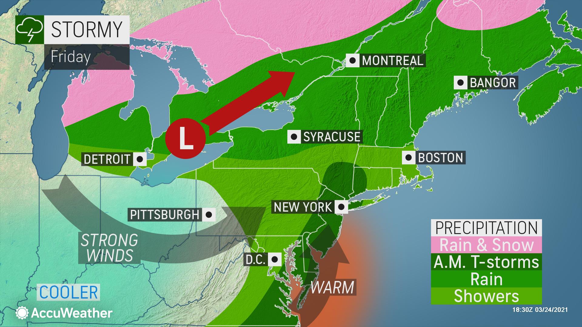
Denver forecast to break 1891 Snowfall Record, as Wintry Storms Threaten Swathes of North America - Electroverse

DENVER FORECAST TO BREAK 1891 SNOWFALL RECORD, AS WINTRY STORMS THREATEN SWATHES OF NORTH AMERICA
MARCH 24, 2021 CAP ALLON
It has been just over a week since Denver was hit by 2+ feet of global warming goodness, and with another wintry storm unfolding, the city is on the cusp of breaking a snowfall record that has stood for 130 years.
As of Tuesday, Denver International Airport was reporting 30.9 inches of snow so far this month, nearly three times the March average. The vast majority of this pow-pow fell over the course of just two days when the one of the biggest snowstorms ever recorded in the city dumped 27.1 inches.
As it stands, March 2021 holds fourth spot on the list of the snowiest Marches on record; and looking up the list, less than half an inch is needed for Denver to surpass the March of 1891, which holds third spot, while 1944’s 32.5 inches, and 2003’s 35.2 inches are also well within reach.
A wintry storm over the Four Corners is forecast to drop 2+ inches over the Denver area by Wednesday afternoon, according to AccuWeather, who add that greater accumulations are expected over the higher elevations, giving a late-season boost to ski resorts across Colorado and southward into New Mexico.
AccuWeather Senior Meteorologist Bob Smerbeck said further opportunities for accumulating snow before the end of the month will arrive this Friday, when two inches is forecast. Another chance will come during the first part of next week, sending the city toward the 2003 record of 35.2 inches.
Elsewhere, much of the Western U.S. will be coated with additional heavy spring snow before March is through:

GFS Total Snowfall March 24 to April 9 [tropicaltidbits.com].
While pockets along the eastern seaboard should be on the lookout for a wintry Nor-Easter early next week, with the likes of Vermont, New Hampshire, Maine, and New Brunswick copping the worst of it:
View: https://twitter.com/PWMwxME/status/1374430075530084357
And finally, much of Canada can also expect something of a late-March burial:

GFS Total Snowfall March 24 to April 9 [tropicaltidbits.com].
The COLD TIMES are returning, the mid-latitudes are REFREEZING in line with the great conjunction, historically low solar activity, cloud-nucleating Cosmic Rays, and a meridional jet stream flow (among other forcings).
Both NOAA and NASA appear to agree, if you read between the lines, with NOAA saying we’re entering a ‘full-blown’ Grand Solar Minimum in the late-2020s, and NASA seeing this upcoming solar cycle (25) as “the weakest of the past 200 years”, with the agency correlating previous solar shutdowns to prolonged periods of global cooling here.
Furthermore, we can’t ignore the slew of new scientific papers stating the immense impact The Beaufort Gyre could have on the Gulf Stream, and therefore the climate overall.
Prepare accordingly— learn the facts, relocate if need be, and grow your own.
DENVER FORECAST TO BREAK 1891 SNOWFALL RECORD, AS WINTRY STORMS THREATEN SWATHES OF NORTH AMERICA
MARCH 24, 2021 CAP ALLON
It has been just over a week since Denver was hit by 2+ feet of global warming goodness, and with another wintry storm unfolding, the city is on the cusp of breaking a snowfall record that has stood for 130 years.
As of Tuesday, Denver International Airport was reporting 30.9 inches of snow so far this month, nearly three times the March average. The vast majority of this pow-pow fell over the course of just two days when the one of the biggest snowstorms ever recorded in the city dumped 27.1 inches.
As it stands, March 2021 holds fourth spot on the list of the snowiest Marches on record; and looking up the list, less than half an inch is needed for Denver to surpass the March of 1891, which holds third spot, while 1944’s 32.5 inches, and 2003’s 35.2 inches are also well within reach.

|
A wintry storm over the Four Corners is forecast to drop 2+ inches over the Denver area by Wednesday afternoon, according to AccuWeather, who add that greater accumulations are expected over the higher elevations, giving a late-season boost to ski resorts across Colorado and southward into New Mexico.
AccuWeather Senior Meteorologist Bob Smerbeck said further opportunities for accumulating snow before the end of the month will arrive this Friday, when two inches is forecast. Another chance will come during the first part of next week, sending the city toward the 2003 record of 35.2 inches.
Elsewhere, much of the Western U.S. will be coated with additional heavy spring snow before March is through:

GFS Total Snowfall March 24 to April 9 [tropicaltidbits.com].
While pockets along the eastern seaboard should be on the lookout for a wintry Nor-Easter early next week, with the likes of Vermont, New Hampshire, Maine, and New Brunswick copping the worst of it:
View: https://twitter.com/PWMwxME/status/1374430075530084357
And finally, much of Canada can also expect something of a late-March burial:

GFS Total Snowfall March 24 to April 9 [tropicaltidbits.com].
The COLD TIMES are returning, the mid-latitudes are REFREEZING in line with the great conjunction, historically low solar activity, cloud-nucleating Cosmic Rays, and a meridional jet stream flow (among other forcings).
Both NOAA and NASA appear to agree, if you read between the lines, with NOAA saying we’re entering a ‘full-blown’ Grand Solar Minimum in the late-2020s, and NASA seeing this upcoming solar cycle (25) as “the weakest of the past 200 years”, with the agency correlating previous solar shutdowns to prolonged periods of global cooling here.
Furthermore, we can’t ignore the slew of new scientific papers stating the immense impact The Beaufort Gyre could have on the Gulf Stream, and therefore the climate overall.
Prepare accordingly— learn the facts, relocate if need be, and grow your own.
TxGal
Day by day
19th coldest February in 127 years - Ice Age Now
19th coldest February in 127 years
March 24, 2021 by Robert
19th coldest February since 1894.
____________
19th coldest February in 127 years
Lloyd Martin Hendaye
At 30.6° Fahrenheit (-0.8°C), February 2021’s mean continental U.S. temperature was 3.2° F (9.5%) below the month’s 20th Century average, ranking this the 19th coldest February since 1894 (127 years).
Of course, this very severe drop accords with our mid-1990s 140-year post-Little Ice Age “amplitude compression” thesis, positing serial 50-40-30-20 year warm-cold spells from AD 1890 to 2029. At that point, intra-decadal oscillations, whipsaw global temperatures, will confirm the onset of a cyclical 102-kiloyear Pleistocene Ice Age dating from AD 1350, ending the 12,550-year Holocene Interglacial Epoch.
Though abrupt chill-phases such as the 1,200-year-long Younger Dryas (12,950 – 11,750 YBP) or Mesopotamia’s devastating Dark Millennium (3,800 – 2,800 YBP) can occur in months, these are not climate-shifts but episodic phenomena due to cometary/meteoritic impacts or oceanic current fluctuations.
As Ice Age Now has long noted, a periodic 12,000-year geomagnetic pole reversal conjoined with Svensmark-Zharkova’s increasing global cloud-cover due to a looming 8-cycle Super-Grand Solar Minimum through AD 2108 per diminished solar magnetic fields (SMFs) may induce abrupt glaciations when winter snows fail to melt in summer.
Over 3.6 million years from the mid-Pliocene, this regularly recurring plate tectonic-driven sequence is due to last another 15 to 25+ million years, affecting Quaternary Periods succeeding the short-lived Pliocene and Pleistocene.
19th coldest February in 127 years
March 24, 2021 by Robert
19th coldest February since 1894.
____________
19th coldest February in 127 years
Lloyd Martin Hendaye
At 30.6° Fahrenheit (-0.8°C), February 2021’s mean continental U.S. temperature was 3.2° F (9.5%) below the month’s 20th Century average, ranking this the 19th coldest February since 1894 (127 years).
Of course, this very severe drop accords with our mid-1990s 140-year post-Little Ice Age “amplitude compression” thesis, positing serial 50-40-30-20 year warm-cold spells from AD 1890 to 2029. At that point, intra-decadal oscillations, whipsaw global temperatures, will confirm the onset of a cyclical 102-kiloyear Pleistocene Ice Age dating from AD 1350, ending the 12,550-year Holocene Interglacial Epoch.
Though abrupt chill-phases such as the 1,200-year-long Younger Dryas (12,950 – 11,750 YBP) or Mesopotamia’s devastating Dark Millennium (3,800 – 2,800 YBP) can occur in months, these are not climate-shifts but episodic phenomena due to cometary/meteoritic impacts or oceanic current fluctuations.
As Ice Age Now has long noted, a periodic 12,000-year geomagnetic pole reversal conjoined with Svensmark-Zharkova’s increasing global cloud-cover due to a looming 8-cycle Super-Grand Solar Minimum through AD 2108 per diminished solar magnetic fields (SMFs) may induce abrupt glaciations when winter snows fail to melt in summer.
Over 3.6 million years from the mid-Pliocene, this regularly recurring plate tectonic-driven sequence is due to last another 15 to 25+ million years, affecting Quaternary Periods succeeding the short-lived Pliocene and Pleistocene.
TheSearcher
Are you sure about that?
Denver forecast to break 1891 Snowfall Record, as Wintry Storms Threaten Swathes of North America - Electroverse
DENVER FORECAST TO BREAK 1891 SNOWFALL RECORD, AS WINTRY STORMS THREATEN SWATHES OF NORTH AMERICA
MARCH 24, 2021 CAP ALLON
It has been just over a week since Denver was hit by 2+ feet of global warming goodness, and with another wintry storm unfolding, the city is on the cusp of breaking a snowfall record that has stood for 130 years.
As of Tuesday, Denver International Airport was reporting 30.9 inches of snow so far this month, nearly three times the March average. The vast majority of this pow-pow fell over the course of just two days when the one of the biggest snowstorms ever recorded in the city dumped 27.1 inches.
As it stands, March 2021 holds fourth spot on the list of the snowiest Marches on record; and looking up the list, less than half an inch is needed for Denver to surpass the March of 1891, which holds third spot, while 1944’s 32.5 inches, and 2003’s 35.2 inches are also well within reach.
A wintry storm over the Four Corners is forecast to drop 2+ inches over the Denver area by Wednesday afternoon, according to AccuWeather, who add that greater accumulations are expected over the higher elevations, giving a late-season boost to ski resorts across Colorado and southward into New Mexico.
AccuWeather Senior Meteorologist Bob Smerbeck said further opportunities for accumulating snow before the end of the month will arrive this Friday, when two inches is forecast. Another chance will come during the first part of next week, sending the city toward the 2003 record of 35.2 inches.
Elsewhere, much of the Western U.S. will be coated with additional heavy spring snow before March is through:
GFS Total Snowfall March 24 to April 9 [tropicaltidbits.com].
While pockets along the eastern seaboard should be on the lookout for a wintry Nor-Easter early next week, with the likes of Vermont, New Hampshire, Maine, and New Brunswick copping the worst of it:
View: https://twitter.com/PWMwxME/status/1374430075530084357
And finally, much of Canada can also expect something of a late-March burial:
GFS Total Snowfall March 24 to April 9 [tropicaltidbits.com].
The COLD TIMES are returning, the mid-latitudes are REFREEZING in line with the great conjunction, historically low solar activity, cloud-nucleating Cosmic Rays, and a meridional jet stream flow (among other forcings).
Both NOAA and NASA appear to agree, if you read between the lines, with NOAA saying we’re entering a ‘full-blown’ Grand Solar Minimum in the late-2020s, and NASA seeing this upcoming solar cycle (25) as “the weakest of the past 200 years”, with the agency correlating previous solar shutdowns to prolonged periods of global cooling here.
Furthermore, we can’t ignore the slew of new scientific papers stating the immense impact The Beaufort Gyre could have on the Gulf Stream, and therefore the climate overall.
Prepare accordingly— learn the facts, relocate if need be, and grow your own.
The ending bound of the snowfall in the Northeast US looks like the glacial boundaries of the last full ice age, IMHO. Am I wrong?
Martinhouse
Deceased
Searcher, if you scroll quite a way down on Robert Felix's site, www.iceagenow.info, you will see on the left side of the page there is a picture that shows the southern boundaries in the United States for the last two full Ice Ages.
TheSearcher
Are you sure about that?
Searcher, if you scroll quite a way down on Robert Felix's site, www.iceagenow.info, you will see on the left side of the page there is a picture that shows the southern boundaries in the United States for the last two full Ice Ages.
That's what i was recollecting, yes. Thank you. I'm just saying that these continued waves of cold going into the Northern American spring, it looks like it keeps coating those boundaries. Given the drastic uptick in vulcanism and the ash-based sunlight blocking that it represents, it makes me wonder about the future. The NEAR future.
ETA: The Map.

Last edited:
northern watch
TB Fanatic
Searcher, if you scroll quite a way down on Robert Felix's site, www.iceagenow.info, you will see on the left side of the page there is a picture that shows the southern boundaries in the United States for the last two full Ice Ages.
Another map

Last edited:
Martinhouse
Deceased
Thank you, northern watch.
TheSearcher
Are you sure about that?
The Iceland volcano live cam is spectacular right now. The smaller vents along the side of the main cone have merged into one, and look to break through and merge with the cone at any time. Lava is flowing everywhere.
northern watch
TB Fanatic
March meltdown
Snow drought is worsening the American West’s water woes
A lack of snow in the Colorado River Basin is exacerbating an existing drought, and heralding future problems
United States
Mar 23rd 2021
The Economist
DENVER
ON MARCH 13TH Denverites watched from frozen windows as the fourth-biggest snowstorm ever to hit their city buried Colorado’s capital two feet deep, and added fresh powder to the foothills of the Rockies. Local officials closed the main highway leading to the mountains lest eager skiers get trapped on icy roads on their way to the slopes. After a dangerously dry 2020 and a warm start to winter, the storm brought eastern Colorado’s winter snowpack (the accumulation of snow) up to average levels. When it melts, water will replenish thirsty reservoirs, rivers and soil. Not everywhere was so lucky. Much of the Mountain West watched the snow falling on Denver with envy.

Drought has afflicted a large swathe of the region for nearly a year (see map). The Colorado River Basin, which includes pieces of seven western states and part of Mexico, has been among the worst-affected areas. A warm spring in 2020 led snow in the mountains to melt early, which depleted the amount of water reservoirs and rivers received during the driest months of the year in summer and autumn. On top of that, the annual monsoons that the south-west depends on never came—and indeed have been lacklustre for four years. The combination of the early melt and a hot, dry summer led to a deadly wildfire season. Colorado and California both suffered their biggest fires on record last year.
Becky Bolinger, Colorado’s assistant state climatologist, says the West has endured multiple prolonged periods of drought since 2000, which have made it impossible for the country’s biggest reservoirs—Lake Mead in Nevada and Lake Powell on the border of Utah and Arizona—to fully recover (see chart). On March 15th the lakes were roughly two-fifths full.

Let it snow
The blizzard that buried Denver did nothing to help ease the drought on the other side of the continental divide. The Rockies split Colorado in two: the Front Range, where most people live on the high plains, and the Western Slope, where waters flow towards the Pacific. The Mountain Studies Institute, a research group in Silverton, estimates that western Colorado has warmed faster than any part of the country, except Alaska. On March 22nd snowpack in the south-western corner of the state was at 83% of its normal level for this time of year. That may not seem too bad, but the region needed above-average precipitation this winter to make up for the past year. Citing a lack of snow, Utah’s governor declared a state of emergency and urged Utahns to find ways to save water. The situation looks bleaker still farther south. Snowpack in parts of Arizona and New Mexico has fallen to less than 50% of average for this time of year.
Average snowpack has been decreasing for decades. Philip Mote, a professor of atmospheric sciences at Oregon State University, found in 2018 that annual snowpack in the American West has declined by 15-30% since 1915. But studying snow drought (and indeed using the term itself) is a recent phenomenon, says Dan McEvoy, a climatologist at the Western Regional Climate Centre in Reno, Nevada. He reckons that warmer winters due to rising carbon-dioxide emissions have made the droughts more frequent and harder to ignore. A lack of snow deprives soil and forests of essential nutrients. It also increases river temperatures and can heighten the risk and severity of wildfires. Unstable snowpack seems also to have contributed to an uptick in avalanche deaths this year.
It’s not just the environment that suffers for want of snow. The economies of many towns in the West are centred around the white stuff and the tourists that come in search of it. “In the ski industry, snow is currency,” says Auden Schendler, the vice-president of sustainability at Aspen Snowmass resort. Winter sports tourism is a $20bn industry in America for which snow drought is an existential threat.
Warm weather blues
Because drought is a perennial problem in the West, adaptation has become a way of life. Conserving water isn’t just a green fad; farmers and ranchers will not survive without it. Some farmers in Colorado and the Pacific Northwest are experimenting with farming without irrigation. State governments are also increasing aid to constituents whose livelihoods are threatened by drought. Colorado’s proposed $700m covid-19 stimulus plan includes up to $55m to fight drought and fire.
These adaptation strategies are a good start. But the future promises ever more complicated water problems. The current compact governing the use of the Colorado River is set to expire in 2026. The agreement, which was negotiated in 1922, called for “upper basin” states, where the river originates, to share water equally with “lower basin” states. Nearly a century later, the compact is showing its age. Today around 40m people depend on the river for water. States, tribes, the Mexican government, developers, environmentalists and farmers, among others, all want a say in how the water is allocated. The lower basin is also home to some of America’s fastest-growing cities, such as Phoenix and Las Vegas.
It would be hard enough drawing up a modern compact that satisfies so many competing interests. Add a shrinking water supply and growing populations, and a battle over the river looms. Individual states are already pressing their cases. Utah, for example, has created a controversial new agency to argue for more water on the state’s behalf. The fight over water, much like the West itself, is heating up.
March meltdown - Snow drought is worsening the American West’s water woes | United States | The Economist
Snow drought is worsening the American West’s water woes
A lack of snow in the Colorado River Basin is exacerbating an existing drought, and heralding future problems
United States
Mar 23rd 2021
The Economist
DENVER
ON MARCH 13TH Denverites watched from frozen windows as the fourth-biggest snowstorm ever to hit their city buried Colorado’s capital two feet deep, and added fresh powder to the foothills of the Rockies. Local officials closed the main highway leading to the mountains lest eager skiers get trapped on icy roads on their way to the slopes. After a dangerously dry 2020 and a warm start to winter, the storm brought eastern Colorado’s winter snowpack (the accumulation of snow) up to average levels. When it melts, water will replenish thirsty reservoirs, rivers and soil. Not everywhere was so lucky. Much of the Mountain West watched the snow falling on Denver with envy.
Drought has afflicted a large swathe of the region for nearly a year (see map). The Colorado River Basin, which includes pieces of seven western states and part of Mexico, has been among the worst-affected areas. A warm spring in 2020 led snow in the mountains to melt early, which depleted the amount of water reservoirs and rivers received during the driest months of the year in summer and autumn. On top of that, the annual monsoons that the south-west depends on never came—and indeed have been lacklustre for four years. The combination of the early melt and a hot, dry summer led to a deadly wildfire season. Colorado and California both suffered their biggest fires on record last year.
Becky Bolinger, Colorado’s assistant state climatologist, says the West has endured multiple prolonged periods of drought since 2000, which have made it impossible for the country’s biggest reservoirs—Lake Mead in Nevada and Lake Powell on the border of Utah and Arizona—to fully recover (see chart). On March 15th the lakes were roughly two-fifths full.
Let it snow
The blizzard that buried Denver did nothing to help ease the drought on the other side of the continental divide. The Rockies split Colorado in two: the Front Range, where most people live on the high plains, and the Western Slope, where waters flow towards the Pacific. The Mountain Studies Institute, a research group in Silverton, estimates that western Colorado has warmed faster than any part of the country, except Alaska. On March 22nd snowpack in the south-western corner of the state was at 83% of its normal level for this time of year. That may not seem too bad, but the region needed above-average precipitation this winter to make up for the past year. Citing a lack of snow, Utah’s governor declared a state of emergency and urged Utahns to find ways to save water. The situation looks bleaker still farther south. Snowpack in parts of Arizona and New Mexico has fallen to less than 50% of average for this time of year.
Average snowpack has been decreasing for decades. Philip Mote, a professor of atmospheric sciences at Oregon State University, found in 2018 that annual snowpack in the American West has declined by 15-30% since 1915. But studying snow drought (and indeed using the term itself) is a recent phenomenon, says Dan McEvoy, a climatologist at the Western Regional Climate Centre in Reno, Nevada. He reckons that warmer winters due to rising carbon-dioxide emissions have made the droughts more frequent and harder to ignore. A lack of snow deprives soil and forests of essential nutrients. It also increases river temperatures and can heighten the risk and severity of wildfires. Unstable snowpack seems also to have contributed to an uptick in avalanche deaths this year.
It’s not just the environment that suffers for want of snow. The economies of many towns in the West are centred around the white stuff and the tourists that come in search of it. “In the ski industry, snow is currency,” says Auden Schendler, the vice-president of sustainability at Aspen Snowmass resort. Winter sports tourism is a $20bn industry in America for which snow drought is an existential threat.
Warm weather blues
Because drought is a perennial problem in the West, adaptation has become a way of life. Conserving water isn’t just a green fad; farmers and ranchers will not survive without it. Some farmers in Colorado and the Pacific Northwest are experimenting with farming without irrigation. State governments are also increasing aid to constituents whose livelihoods are threatened by drought. Colorado’s proposed $700m covid-19 stimulus plan includes up to $55m to fight drought and fire.
These adaptation strategies are a good start. But the future promises ever more complicated water problems. The current compact governing the use of the Colorado River is set to expire in 2026. The agreement, which was negotiated in 1922, called for “upper basin” states, where the river originates, to share water equally with “lower basin” states. Nearly a century later, the compact is showing its age. Today around 40m people depend on the river for water. States, tribes, the Mexican government, developers, environmentalists and farmers, among others, all want a say in how the water is allocated. The lower basin is also home to some of America’s fastest-growing cities, such as Phoenix and Las Vegas.
It would be hard enough drawing up a modern compact that satisfies so many competing interests. Add a shrinking water supply and growing populations, and a battle over the river looms. Individual states are already pressing their cases. Utah, for example, has created a controversial new agency to argue for more water on the state’s behalf. The fight over water, much like the West itself, is heating up.
March meltdown - Snow drought is worsening the American West’s water woes | United States | The Economist
northern watch
TB Fanatic
northern watch
TB Fanatic
TxGal
Day by day
Adapt 2030 has a new podcast out:
Polar Spring is from Volcanic Eruptions Globally - YouTube
Polar Spring is from Volcanic Eruptions Globally
16,034 views • Mar 24, 2021
View: https://youtu.be/eecUWqUCT7Q
Run time is 12:02
Synopsis provided:
Media suddenly picks up on the term Polar Spring to explain the abnormal cold and snowfall events happening in March and predicted to last through April. Much of the cooling is from multiple volcanic eruptions above 40,000 ft across the globe. Other strangeness is that Monarch Butterflies are down 26% in migration numbers and Arctic Walrus spotted off Ireland and Wales.
Polar Spring is from Volcanic Eruptions Globally - YouTube
Polar Spring is from Volcanic Eruptions Globally
16,034 views • Mar 24, 2021
Run time is 12:02
Synopsis provided:
Media suddenly picks up on the term Polar Spring to explain the abnormal cold and snowfall events happening in March and predicted to last through April. Much of the cooling is from multiple volcanic eruptions above 40,000 ft across the globe. Other strangeness is that Monarch Butterflies are down 26% in migration numbers and Arctic Walrus spotted off Ireland and Wales.
TxGal
Day by day
UK on for Record April Snow, as Rare March Blizzards Blanket Turkey, Cyprus, Algeria, Taiwan, and India - Electroverse

UK ON FOR RECORD APRIL SNOW, AS RARE MARCH BLIZZARDS BLANKET TURKEY, CYPRUS, ALGERIA, TAIWAN, AND INDIA
MARCH 25, 2021 CAP ALLON
We’re fast approaching April, but this, the first of the GRAND SOLAR MINIMUM winters is refusing to let up.
At times, brief pockets of warmth have prevailed, giving the false sense of spring –I’ve been caught out a few times myself with regards to planting out cold-tender crops– but the Arctic is always looming, threatening to descend south on the back of a low-solar-activity-induced “meridional” jet stream flow.
Case in point: while the UK can look forward to some seasonable warmth on Monday and Tuesday, a violently buckling jet stream looks set to plunge the country back into full-blown winter during the first week of April:
UK ON FOR RECORD APRIL SNOW
“Britain in for 20C mini-scorcher – and sunny spell to last NINE days,” reads a headline from thesun.co.uk.
“The blast of sunshine is expected to begin this weekend and continue well into April,” writes reporter Alice Fuller, who it would appear is incapable of deciphering a weather model for herself.
In reality, snow is forecast for swathes of the UK this weekend:

GFS Total Snowfall (cm) March 25 to March 29 [tropicaltidbits.com].
While visualized below is the “mini-scorcher” purportedly on the horizon:

Firstly, “mini” is indeed the word, as the “scorcher” runs for just two days (Mon & Tue), and not the reported NINE.
And secondly, it appears the pleasant spring temps will be quickly-chased by brutal Arctic cold and record April snow across the entire British Isles (as well as Scandinavia, Belgium, Germany, the Alps, & Turkey, among others):

GFS Total Snowfall (cm) April 2 to April 10 [tropicaltidbits.com].
At 186 to 384 hours out, the forecast is within the unreliable time-frame, and so is subject to change; however, multiple weather models (including the GFS and EMCWF) are in basic agreement — Britain (and Europe) can expect heavy, record-breaking snowfall next month.
RARE MARCH SNOW BLANKETS TURKEY, CYPRUS, ALGERIA, INDIA, AND TAIWAN
TURKEY
Istanbul was battered by heavy snowfall on Wednesday, grinding the city’s traffic to a halt — the snow is an unusual occurrence for this time of year, reports dailysabah.com.
Although the meteorology forecast had warned of snow, most people were expecting the event to be a fleeting one, in a month usually associated with warm, if not outright hot, weather, continues the dailysabah.com article.

People walk in a street as heavy snowfall hits the Okmeydanı neighborhood in Istanbul, Turkey, March 24, 2021. (AA PHOTO)
Temperatures dropped dramatically across Turkey on Monday, and the snow was particularly dense in the eastern parts: the capital Ankara was hit late Tuesday, and the snow continued into Wednesday reaching a depth of 30 cm (1 foot) — long traffic jams soon formed, as municipality crews worked to clear the roads.
Roads to 97 villages were closed due to snowfall in the central province of Çorum.
While the majority of village roads in the western province of Bilecik were also blocked.
CYPRUS
Following a brief summer spell, Cypriots woke up to a chill Wednesday as temperatures plunged a full 3 degrees Celsius below the seasonal average.
A webcam near the Jubilee Hotel showed steady snow falling throughout the day.

Speaking to the Financial Mirror, a Met Office official said Cyprus will be leaving the hot weather behind as temperatures this week will hold around freezing across the higher elevations, while the Troodos mountains can expect further flurries on Thursday and Friday.
ALGERIA
Arctic air has descended into northern Africa, too.
Ennahar Tv Plus on YouTube reveals “enchanting scenes of the world-rare Atlantic cedar trees clad in white” in Algeria:
View: https://youtu.be/RS6nwYgVYqE
Run time is 0:30
TAIWAN
Taiwan’s tallest peak, Yushan, also saw rare March snow on Wednesday.
According to the Central Weather Bureau (CWB), the temperature hovered around the freezing mark and at 7:10am on Wednesday morning, show began falling on the north face of Yushan.
View: https://youtu.be/XBMh1wx8Tfw
Run time is 0:28
The CWB said precipitation continued to fall throughout the day, but was a mixture of snow, sleet and ice pellets.
INDIA
Unexpected blizzards thrilled tourists at Solang valley near Manali on Monday, reports timesofindia.com.
Heavy snow blocked many roads in Lahaul and upper Manali after more than 30cm (1 foot) fell in some parts.
View: https://youtu.be/xng6wl8EE9k
Run time is 1:46
Record snow also covered Hemkund Sahib–a Sikh place of worship and pilgrimage site in Chamoli district:
View: https://youtu.be/nQHGRkt00DQ
Run time is 1:19
Furthermore, Total Snowfall fro the Northern Hemisphere took a jump back up on the latest observation point (from March 23) to some 350 Gigatons above the 1982-2012 average:

[FMI]
And finally, it would appear that Global Warming has taken the first quarter of 2021 off.
Temperature anomalies for the year to date (to March 22) reveal our planet has been “cooking” at just 0.09C above the 1991-2020 climatological average — hardly signs of an impending fiery doom:

Give it up, alarmists.
Find yourselves another crusade.
The COLD TIMES are returning, the mid-latitudes are REFREEZING in line with the great conjunction, historically low solar activity, cloud-nucleating Cosmic Rays, and a meridional jet stream flow (among other forcings).
Both NOAA and NASA appear to agree, if you read between the lines, with NOAA saying we’re entering a ‘full-blown’ Grand Solar Minimum in the late-2020s, and NASA seeing this upcoming solar cycle (25) as “the weakest of the past 200 years”, with the agency correlating previous solar shutdowns to prolonged periods of global cooling here.
Furthermore, we can’t ignore the slew of new scientific papers stating the immense impact The Beaufort Gyre could have on the Gulf Stream, and therefore the climate overall.
Prepare accordingly— learn the facts, relocate if need be, and grow your own.
UK ON FOR RECORD APRIL SNOW, AS RARE MARCH BLIZZARDS BLANKET TURKEY, CYPRUS, ALGERIA, TAIWAN, AND INDIA
MARCH 25, 2021 CAP ALLON
We’re fast approaching April, but this, the first of the GRAND SOLAR MINIMUM winters is refusing to let up.
At times, brief pockets of warmth have prevailed, giving the false sense of spring –I’ve been caught out a few times myself with regards to planting out cold-tender crops– but the Arctic is always looming, threatening to descend south on the back of a low-solar-activity-induced “meridional” jet stream flow.
Case in point: while the UK can look forward to some seasonable warmth on Monday and Tuesday, a violently buckling jet stream looks set to plunge the country back into full-blown winter during the first week of April:
UK ON FOR RECORD APRIL SNOW
“Britain in for 20C mini-scorcher – and sunny spell to last NINE days,” reads a headline from thesun.co.uk.
“The blast of sunshine is expected to begin this weekend and continue well into April,” writes reporter Alice Fuller, who it would appear is incapable of deciphering a weather model for herself.
In reality, snow is forecast for swathes of the UK this weekend:

GFS Total Snowfall (cm) March 25 to March 29 [tropicaltidbits.com].
While visualized below is the “mini-scorcher” purportedly on the horizon:
Firstly, “mini” is indeed the word, as the “scorcher” runs for just two days (Mon & Tue), and not the reported NINE.
And secondly, it appears the pleasant spring temps will be quickly-chased by brutal Arctic cold and record April snow across the entire British Isles (as well as Scandinavia, Belgium, Germany, the Alps, & Turkey, among others):

GFS Total Snowfall (cm) April 2 to April 10 [tropicaltidbits.com].
At 186 to 384 hours out, the forecast is within the unreliable time-frame, and so is subject to change; however, multiple weather models (including the GFS and EMCWF) are in basic agreement — Britain (and Europe) can expect heavy, record-breaking snowfall next month.
RARE MARCH SNOW BLANKETS TURKEY, CYPRUS, ALGERIA, INDIA, AND TAIWAN
TURKEY
Istanbul was battered by heavy snowfall on Wednesday, grinding the city’s traffic to a halt — the snow is an unusual occurrence for this time of year, reports dailysabah.com.
Although the meteorology forecast had warned of snow, most people were expecting the event to be a fleeting one, in a month usually associated with warm, if not outright hot, weather, continues the dailysabah.com article.

People walk in a street as heavy snowfall hits the Okmeydanı neighborhood in Istanbul, Turkey, March 24, 2021. (AA PHOTO)
Temperatures dropped dramatically across Turkey on Monday, and the snow was particularly dense in the eastern parts: the capital Ankara was hit late Tuesday, and the snow continued into Wednesday reaching a depth of 30 cm (1 foot) — long traffic jams soon formed, as municipality crews worked to clear the roads.
Roads to 97 villages were closed due to snowfall in the central province of Çorum.
While the majority of village roads in the western province of Bilecik were also blocked.
CYPRUS
Following a brief summer spell, Cypriots woke up to a chill Wednesday as temperatures plunged a full 3 degrees Celsius below the seasonal average.
A webcam near the Jubilee Hotel showed steady snow falling throughout the day.

Speaking to the Financial Mirror, a Met Office official said Cyprus will be leaving the hot weather behind as temperatures this week will hold around freezing across the higher elevations, while the Troodos mountains can expect further flurries on Thursday and Friday.
ALGERIA
Arctic air has descended into northern Africa, too.
Ennahar Tv Plus on YouTube reveals “enchanting scenes of the world-rare Atlantic cedar trees clad in white” in Algeria:
Run time is 0:30
TAIWAN
Taiwan’s tallest peak, Yushan, also saw rare March snow on Wednesday.
According to the Central Weather Bureau (CWB), the temperature hovered around the freezing mark and at 7:10am on Wednesday morning, show began falling on the north face of Yushan.
Run time is 0:28
The CWB said precipitation continued to fall throughout the day, but was a mixture of snow, sleet and ice pellets.
INDIA
Unexpected blizzards thrilled tourists at Solang valley near Manali on Monday, reports timesofindia.com.
Heavy snow blocked many roads in Lahaul and upper Manali after more than 30cm (1 foot) fell in some parts.
Run time is 1:46
Record snow also covered Hemkund Sahib–a Sikh place of worship and pilgrimage site in Chamoli district:
Run time is 1:19
Furthermore, Total Snowfall fro the Northern Hemisphere took a jump back up on the latest observation point (from March 23) to some 350 Gigatons above the 1982-2012 average:
[FMI]
And finally, it would appear that Global Warming has taken the first quarter of 2021 off.
Temperature anomalies for the year to date (to March 22) reveal our planet has been “cooking” at just 0.09C above the 1991-2020 climatological average — hardly signs of an impending fiery doom:

Give it up, alarmists.
Find yourselves another crusade.
The COLD TIMES are returning, the mid-latitudes are REFREEZING in line with the great conjunction, historically low solar activity, cloud-nucleating Cosmic Rays, and a meridional jet stream flow (among other forcings).
Both NOAA and NASA appear to agree, if you read between the lines, with NOAA saying we’re entering a ‘full-blown’ Grand Solar Minimum in the late-2020s, and NASA seeing this upcoming solar cycle (25) as “the weakest of the past 200 years”, with the agency correlating previous solar shutdowns to prolonged periods of global cooling here.
Furthermore, we can’t ignore the slew of new scientific papers stating the immense impact The Beaufort Gyre could have on the Gulf Stream, and therefore the climate overall.
Prepare accordingly— learn the facts, relocate if need be, and grow your own.
northern watch
TB Fanatic

TxGal
Day by day
Adapt 2030 has a new podcast out:
Volcanic Eruptions, Solar Activity & Extreme Weather Spring Forecast - YouTube
Volcanic Eruptions, Solar Activity & Extreme Weather Spring Forecast
858 views • Mar 26, 2021
View: https://youtu.be/XkoJctphEJk
Run time is 17:38
Synopsis provided:
Eric Gajewski from Tradcatknight.org and David DuByne from ADAPT 2030 discuss Earth changes and what it means for our world from 2021-2024 with repeating cycles and how prophecy intertwines these times.
•Global volcanic eruptions causing cooling
•COVID travel stoppages reduced CO2 levels 5% in 2020
•Solar activity ramp-up is below average intensity for SC 25
•Atlantic Ocean current slowing
•Tornado Forecast Spring 2021
Volcanic Eruptions, Solar Activity & Extreme Weather Spring Forecast - YouTube
Volcanic Eruptions, Solar Activity & Extreme Weather Spring Forecast
858 views • Mar 26, 2021
Run time is 17:38
Synopsis provided:
Eric Gajewski from Tradcatknight.org and David DuByne from ADAPT 2030 discuss Earth changes and what it means for our world from 2021-2024 with repeating cycles and how prophecy intertwines these times.
•Global volcanic eruptions causing cooling
•COVID travel stoppages reduced CO2 levels 5% in 2020
•Solar activity ramp-up is below average intensity for SC 25
•Atlantic Ocean current slowing
•Tornado Forecast Spring 2021
TxGal
Day by day
The Oppenheimer Ranch Project has a new podcast out:
Iceland Volcano Update! Increased Tholieitic Lava Flowing From The Mantle Expected To Last For Years - YouTube
Iceland Volcano Update! Increased Tholieitic Lava Flowing From The Mantle Expected To Last For Years
2,924 views • Premiered 9 hours ago
View: https://youtu.be/PGRStfvm-Yo
Run time is 11:27
Synopsis provided:
Long eruption is now expected in Fagradalsfjall in Geldingadalir valley (soon a former valley) based on lava chemical details https://bit.ly/2P7ozyG
Volcanic Alert Level Raised; Cleveland Could Blow https://bit.ly/3fdUkRl
Worldwide Volcano News http://bit.ly/2v9JJhO
Soufrière St Vincent volcano (West Indies): lava dome continues to grow slowly https://bit.ly/3lRJEJc
The Reykjanes eruption: a look underground https://bit.ly/2QJnVbf https://spaceweathernews.com/
Reykjanes peninsula - earthquakes https://bit.ly/3rprWPn
Characterisation of rock samples collected on the 1st and 2nd days of the eruption - major elements and mineral chemistry https://bit.ly/2Pyh9nK
Tholeiitic magma series https://bit.ly/3lTSO80
3D Map Of The Region https://bit.ly/3spUCZ8 Live from Geldingadalir volcano, Iceland https://bit.ly/3tV8URH
Minor earthquake swarm on Tjörnes Fracture Zone (east of Grímsey island) https://icelandgeology.net/
Iceland Volcano Update! Increased Tholieitic Lava Flowing From The Mantle Expected To Last For Years - YouTube
Iceland Volcano Update! Increased Tholieitic Lava Flowing From The Mantle Expected To Last For Years
2,924 views • Premiered 9 hours ago
Run time is 11:27
Synopsis provided:
Long eruption is now expected in Fagradalsfjall in Geldingadalir valley (soon a former valley) based on lava chemical details https://bit.ly/2P7ozyG
Volcanic Alert Level Raised; Cleveland Could Blow https://bit.ly/3fdUkRl
Worldwide Volcano News http://bit.ly/2v9JJhO
Soufrière St Vincent volcano (West Indies): lava dome continues to grow slowly https://bit.ly/3lRJEJc
The Reykjanes eruption: a look underground https://bit.ly/2QJnVbf https://spaceweathernews.com/
Reykjanes peninsula - earthquakes https://bit.ly/3rprWPn
Characterisation of rock samples collected on the 1st and 2nd days of the eruption - major elements and mineral chemistry https://bit.ly/2Pyh9nK
Tholeiitic magma series https://bit.ly/3lTSO80
3D Map Of The Region https://bit.ly/3spUCZ8 Live from Geldingadalir volcano, Iceland https://bit.ly/3tV8URH
Minor earthquake swarm on Tjörnes Fracture Zone (east of Grímsey island) https://icelandgeology.net/
TxGal
Day by day
It's Spring, 2021 - Grow your Own already - Grand Solar Minimum - Electroverse

IT’S SPRING, 2021 — GROW YOUR OWN ALREADY — GRAND SOLAR MINIMUM
MARCH 26, 2021 CAP ALLON
I’m working on a new ‘preparedness’ website.
It will be free to access and will hopefully give people a comprehensive understanding of off-grid living and 100% self-sufficiency in order to survive the coming COLD TIMES and associated societal collapse.
Below is a taster — let me know if there’s any interest for such a resource, or if I’m wasting my time.
Thanks, Cap.
GROW YOUR OWN POTATOES
Potatoes are the main staple of our homestead.
They contain all the essential amino acids you need to build proteins, repair cells, and fight diseases — eating just five spuds a day would technically keep you alive (although eventually you’d run into vitamin and mineral deficiencies) which explains why for time-immemorial this crop has been grown as a “safety net” in the event that other, harder to grow harvests, fail.
You don’t need as much space as you may think to grow a decent hoard. We have just two potato patches, each measuring approximately 3 x 3 meters (10 x 10 feet), and we “succession plant” — for us, this means planting our first crop early in the season (mid-Jan), our second crop then goes in around May, and our third is sown September-time. This tactic keeps us in potatoes all year round, and we have never run into issues caused by a lack of rotation.
There are so many vegetable-growing myths and old wives’ tales doing the rounds out there, and most are complete and utter garbage. It’s frustrating. Honestly, feel free to throw most of the ‘advice’ out the window, and simply try things out in your local area — climate, pests, and soil can vary greatly even from town to town, let alone from nation to nation.
Below is how we successfully grow potatoes.
CHITTING
Before we plant our spuds we allow them to “chit” — a word our young sons enjoy repeating regularly. Basically, the process involves laying seed potatoes in the light to encourage sprouting. The step isn’t essential by any means, but we have found it gives the spuds a head-start, promoting faster initial growth. We begin chitting our potatoes around 4-6 weeks in advance of planting out (so around early December-time for our first crop), and by mid-January small purple shoots will be peppering the potatoes.
“NO-DIG” POTATOES
Again, there are wildly varying opinions on how to best grow potatoes.
As always, we shoot for the simplest method, which is “no-dig” devised by Charles Dowding.
At the beginning of each season we “top up” our potato beds with around 10cm (4 inches) of homemade compost, and this will see the bed through the year’s three harvests — there is no digging, and minimal raking.
We plant our sprouting spuds about 15 cm (6 inches) deep into the prepare bed, at a spacing of around 30cm (a foot). We’ve tried many different spacing permutations over the years, but this works best for us — it seems to minimize disease by allowing enough airflow between plants, while at the same time the relatively close proximity of the plants acts as a mulch: their leaves shade the entire patch, helping with moisture retention and temperature regulation.
One tip: as your potatoes grow, you’ll want to check that those near the surface stay covered, exposure to sunlight will turn your spuds green and they can become toxic.
HILLING POTATOES
An alternative to the no-dig method is to “hill” your potatoes; if compost is at a premium, then this may be a better option for you.
Dig trenches 15-20cm (6-8 inches) deep at around 45-60cm apart.
Place your potatoes in the trenches –sprouts pointing up– between 30-45cm (12-18 inches) apart, and then cover the trenches over.
When the plants reach around 15cm (6 inches) in height, cover them over again with more soil so that just the very top leaves are exposed. This will encourage new potatoes to grow. Continuing to cover the plants over when they reach 30cm (12 inches) and then 45cm (18 inches) will keep encouraging new potatoes to grow. You can cover them as many times as you like, within reason.
GROWING
Potatoes are a low maintenance crop, but there are a few things to keep in mind to ensure you achieve a good quality harvest.
Firstly and foremost, keep your plants well watered, particularly through spells of hot weather.
Potato plants can flower, and if left long enough will produce small, green tomato-like fruit. Flowering and fruiting are not determining factors when it comes to harvesting, though — we’ve had crops that have been ready both before flowering and also well after fruits had set.
Leaves turning yellow and beginning to die back are the best indicators that harvest is approaching — this is also the time to cease watering, which will help to begin the curing process, readying them for long term storage.
HARVESTING
Potatoes will be ready for harvest a week or two after the foliage dies back.
To see if they’re done, dig up a potato and rub it with you thumb, if the skin comes off they will need a few more days; alternatively, harvest now if you’re after a crop closer to new potatoes.
If you grew using the no dig method then your potatoes will be relatively near the surface and so you should be able to harvest with your hands; however, if your spuds are deeper you may need to use a fork — do this with care as the fork will easily pierce potatoes and these will not store.

STORAGE
Cured potatoes will need to be kept in the dark to avoid them sprouting, turning green and spoiling. They will also store longer in cool temperatures. Be sure to leave some dirt on the spuds, too — do not wash them.
The storing process needn’t be complicated, though.
We simply bag our harvest up in burlap sacks and keep them in our under-trailer storage compartment, where they last just fine — the temp fluctuates wildly in there, but it is kept dark, and the potatoes keep just fine.
Also, us growing three harvests a year means the potatoes we dig up never need to store for all that long a time — we never need a spud to last longer than 3 or 4 months, which our storing setup manages with ease.
Also also, be sure to save some back for your next crop.
Grow your own, keep it simple, achieve self-sufficiency; reject the processed poison on offer at the supermarkets, and prepare for the ever-intensifying GRAND SOLAR MINIMUM.
The COLD TIMES are returning, the mid-latitudes are REFREEZING in line with the great conjunction, historically low solar activity, cloud-nucleating Cosmic Rays, and a meridional jet stream flow (among other forcings).
Both NOAA and NASA appear to agree, if you read between the lines, with NOAA saying we’re entering a ‘full-blown’ Grand Solar Minimum in the late-2020s, and NASA seeing this upcoming solar cycle (25) as “the weakest of the past 200 years”, with the agency correlating previous solar shutdowns to prolonged periods of global cooling here.
Furthermore, we can’t ignore the slew of new scientific papers stating the immense impact The Beaufort Gyre could have on the Gulf Stream, and therefore the climate overall.
Prepare accordingly— learn the facts, relocate if need be, and grow your own.
I used to ask farmers if I could gleen potatoes, carrots, onions from their fields once they had finished getting their fall crops in. Going through the fields with my garden fork, I could usually find enough of each to get us through the winter. usually the sizes were small, but the taste in our mouths was sweet! A day or two of hard work and a huge thank you to the farmer was my cost. Good folks............
TxGal
Day by day
Ada[t 2030 has a new podcast out:
Unprecedented Global Snows Continue With the Economic Reset Catalyst - YouTube
Unprecedented Global Snows Continue With the Economic Reset Catalyst
8,112 views • Mar 27, 2021
View: https://youtu.be/0OCdkHlBpR8
Run time is 11:56
Synopsis provided:
Unprecedented Global Snow events from Taiwan to Cyprus and now the emergence of the excuse for a global financial lock up as oil drips to a halt by way of export from the Middle East Suez Canal Route.
Unprecedented Global Snows Continue With the Economic Reset Catalyst - YouTube
Unprecedented Global Snows Continue With the Economic Reset Catalyst
8,112 views • Mar 27, 2021
Run time is 11:56
Synopsis provided:
Unprecedented Global Snow events from Taiwan to Cyprus and now the emergence of the excuse for a global financial lock up as oil drips to a halt by way of export from the Middle East Suez Canal Route.
northern watch
TB Fanatic
Beijing enveloped in hazardous sandstorm, second time in two weeks
By Reuters Staff
MARCH 27, 20218:59 PM UPDATED 4 HOURS AGO

FILE PHOTO: A general view of the city shrouded in smog after a sandstorm, in central Beijing, China March 15, 2021. REUTERS/Tingshu Wang
BEIJING (Reuters) - The Chinese capital Beijing woke on Sunday morning shrouded in thick dust carrying extremely high levels of hazardous particles, as a second sandstorm in two weeks hit the city due to winds from drought-hit Mongolia and northwestern China.
Visibility in the city was reduced, with the tops of some skyscrapers obscured by the sandstorm, and pedestrians were forced to cover their eyes as gusts of dust swept through the streets.
Beijing’s official air quality index reached a maximum level of 500 on Sunday morning, with floating particles known as PM10 surpassing 2,000 micrograms per cubic metre in some districts.
Readings of smaller PM2.5 particles were above 300 micrograms per cubic metre, far higher than China’s standard of 35 micrograms.
PM2.5 particles are especially harmful because they are very tiny and can enter the bloodstream, while PM10 is a larger particle that can enter the lungs.
The China Meteorological Administration issued a yellow alert on Friday, warning that a sandstorm was spreading from Mongolia into northern Chinese provinces including Inner Mongolia, Shanxi, Liaoning and Hebei, which surrounds Beijing.
The meteorological office said the recent sandstorms to hit Beijing originated from Mongolia, where relatively warmer temperature this spring and reduced rain resulted in larger areas of bare earth, creating favorable conditions for sandstorms.
Beijing might face more sandstorms in April due to the unfavorable weather this year, the meteorological office said.
Reporting by Sophie Yu, Judy Hua and Martin Pollard; Editing by Michael Perry
Beijing enveloped in hazardous sandstorm, second time in two weeks | Reuters
By Reuters Staff
MARCH 27, 20218:59 PM UPDATED 4 HOURS AGO
FILE PHOTO: A general view of the city shrouded in smog after a sandstorm, in central Beijing, China March 15, 2021. REUTERS/Tingshu Wang
BEIJING (Reuters) - The Chinese capital Beijing woke on Sunday morning shrouded in thick dust carrying extremely high levels of hazardous particles, as a second sandstorm in two weeks hit the city due to winds from drought-hit Mongolia and northwestern China.
Visibility in the city was reduced, with the tops of some skyscrapers obscured by the sandstorm, and pedestrians were forced to cover their eyes as gusts of dust swept through the streets.
Beijing’s official air quality index reached a maximum level of 500 on Sunday morning, with floating particles known as PM10 surpassing 2,000 micrograms per cubic metre in some districts.
Readings of smaller PM2.5 particles were above 300 micrograms per cubic metre, far higher than China’s standard of 35 micrograms.
PM2.5 particles are especially harmful because they are very tiny and can enter the bloodstream, while PM10 is a larger particle that can enter the lungs.
The China Meteorological Administration issued a yellow alert on Friday, warning that a sandstorm was spreading from Mongolia into northern Chinese provinces including Inner Mongolia, Shanxi, Liaoning and Hebei, which surrounds Beijing.
The meteorological office said the recent sandstorms to hit Beijing originated from Mongolia, where relatively warmer temperature this spring and reduced rain resulted in larger areas of bare earth, creating favorable conditions for sandstorms.
Beijing might face more sandstorms in April due to the unfavorable weather this year, the meteorological office said.
Reporting by Sophie Yu, Judy Hua and Martin Pollard; Editing by Michael Perry
Beijing enveloped in hazardous sandstorm, second time in two weeks | Reuters
TxGal
Day by day
The Oppenheimer Ranch Project has a new podcast out:
Severe Weather In The Mid Atlantic on Sunday (Flooding) - Iceland Volcanic Update - Parasitic Elites - YouTube
Severe Weather In The Mid Atlantic on Sunday (Flooding) - Iceland Volcanic Update - Parasitic Elites
3,879 views • Premiered 8 hours ago
View: https://youtu.be/BoeibwhuRf0
Run time is 25:05
Synopsis provided:
Flooding reported as severe storms moved through Middle Tennessee https://bit.ly/3rrZEmE
Maryland Weather: Severe Storms Possible Throughout Much Of The Region Sunday Afternoon https://cbsloc.al/3w609WY
Severe Weather Threat Moves into Alabama After Midnight https://bit.ly/2PBQF56
Most of North Carolina under Level 2 severe weather risk on Sunday https://abc11.tv/3stqgEY
Severe weather impacts the ArkLaTex Saturday evening https://bit.ly/39ogaxP
From snow to 60s, the warmup begins tomorrow https://bit.ly/3w03tD3
SNOWFALL ANALYSIS FROM THE LAST 48 HOURS https://www.weather.gov/crh/snowfall
Severe Storms Shift East; High Winds in the Northern Plains https://www.weather.gov/
IT’S SPRING, 2021 — GROW YOUR OWN ALREADY — GRAND SOLAR MINIMUM https://bit.ly/3fjOde6
Arctic Sea Ice Thickness https://bit.ly/3ctBLa1
Worldwide Volcano News http://bit.ly/2v9JJhO
Indonesian 'Mountain of Fire' Erupts Again https://n.pr/3u3ZS4O Update on the eruption in Geldingadalir on 27-March-2021 https://bit.ly/313mSWn
Live from Geldingadalir volcano, Iceland https://bit.ly/3tV8URH
and more
Severe Weather In The Mid Atlantic on Sunday (Flooding) - Iceland Volcanic Update - Parasitic Elites - YouTube
Severe Weather In The Mid Atlantic on Sunday (Flooding) - Iceland Volcanic Update - Parasitic Elites
3,879 views • Premiered 8 hours ago
Run time is 25:05
Synopsis provided:
Flooding reported as severe storms moved through Middle Tennessee https://bit.ly/3rrZEmE
Maryland Weather: Severe Storms Possible Throughout Much Of The Region Sunday Afternoon https://cbsloc.al/3w609WY
Severe Weather Threat Moves into Alabama After Midnight https://bit.ly/2PBQF56
Most of North Carolina under Level 2 severe weather risk on Sunday https://abc11.tv/3stqgEY
Severe weather impacts the ArkLaTex Saturday evening https://bit.ly/39ogaxP
From snow to 60s, the warmup begins tomorrow https://bit.ly/3w03tD3
SNOWFALL ANALYSIS FROM THE LAST 48 HOURS https://www.weather.gov/crh/snowfall
Severe Storms Shift East; High Winds in the Northern Plains https://www.weather.gov/
IT’S SPRING, 2021 — GROW YOUR OWN ALREADY — GRAND SOLAR MINIMUM https://bit.ly/3fjOde6
Arctic Sea Ice Thickness https://bit.ly/3ctBLa1
Worldwide Volcano News http://bit.ly/2v9JJhO
Indonesian 'Mountain of Fire' Erupts Again https://n.pr/3u3ZS4O Update on the eruption in Geldingadalir on 27-March-2021 https://bit.ly/313mSWn
Live from Geldingadalir volcano, Iceland https://bit.ly/3tV8URH
and more
TxGal
Day by day
Super-cold thunderstorm sets temperature record, scientists note increase in last 20 years -- Earth Changes -- Sott.net
Super-cold thunderstorm sets temperature record, scientists note increase in last 20 years
Jonathan Amos
BBC
Sun, 28 Mar 2021 11:56 UTC

© SPL
Cumulonimbus incus: The anvil shape forms when the rising cloud reaches the tropopause
We've all seen those majestic anvil storm clouds that form on a hot summer's day, but what do you think is the temperature right at the very top?
It's very cold, obviously; at high altitude it is well below freezing.
But would you be surprised to learn it is sometimes below even -100C?
Indeed, scientists have just published research showing the top of one tropical storm cloud system in 2018 reached -111C. This is very likely a record low temperature.
It was seen on 29 December that year, just south of the equator in the western Pacific. The measurement was made by a passing American satellite, Noaa-20.
When a powerful upward draft reaches the top of the lower atmosphere, or troposphere, it will normally flatten and spread out to form that classic anvil shape.
But if the storm is very energetic, the upward movement of air can punch through the troposphere's ceiling, the tropopause, to keep on rising into the stratosphere, the next layer up in the atmosphere. In the 2018 event, the cloud top was at about 20.5km in altitude.

"It's called an overshooting top," explains Dr Simon Proud, a Nerc research fellow in satellite remote sensing at the National Centre for Earth Observation and Oxford University, UK.
"Overshooting tops are reasonably common. We get them over the UK as well, sometimes - like last August when we had a number of massive storms. But this was a very big overshoot. Normally, an overshooting top cools by about 7C for every kilometre it goes above the tropopause; and this one was about 13C or 14C cooler than the tropopause - so, a pretty big overshoot," he told BBC News.

© NASA
An example of an overshooting top: See the area of unevenness bursting through the flat surface
Dr Proud and Scott Bachmeier, a research meteorologist at the University of Wisconsin-Madison, US, report the event in a paper in the journal Geophysical Research Letters.
They describe the contributing factors. Although big storms in that part of the Pacific are frequent around the December-January timeframe, this one seemed to get an extra boost.
In part, this came from some very warm ocean water in the region, but there was help too from a phenomenon meteorologists refer to as the Madden-Julian Oscillation. The MJO is an eastwards-moving zone of winds that can accentuate wet and dry weather.
What's noteworthy, however, is the hint in the long-term data that these super-cold thunderstorms may be increasing in frequency.
There have been as many such events across the globe in the past three years as there were in the 13 years before that. That's relevant as, in general, the colder the storm, the more likely it is to produce hazardous weather, such as lightning and flooding.
"The storm we report on was in the middle of nowhere, and just as well," says Dr Proud.
"If you'd been there you would have got drenched and very probably a load of hail on your head as well - and a lot of lightning.
"Over the last 20 years, it seems these super-cold thunderstorms are becoming a little bit more common. It's interesting that in this part of the world, the tropopause is actually getting warmer, so we might expect to see warmer clouds, not colder clouds, which likely means we're seeing more extreme storms as we're getting even bigger overshoots than we used to."

© Ball Aerospace
Artwork: Noaa-20 is an American low-orbiting satellite that feeds data into weather forecasts
The meteorological agencies are aware that not all the satellite sensors they fly today are capable of measuring the extreme low temperatures recorded by Noaa-20's Visible Infrared Imaging Radiometer (Viirs). Improved capability is therefore necessary, especially since the American spacecraft on that day probably didn't capture the absolute low temperature reached in the cloud top.
It flew over at three o'clock and the peak of activity was about half-four.
Comment: That we are experiencing a significant shift in conditions on our planet can be seen in the numerous, varied and unusual phenomena in our skies:
- Gigantic jet photographed piercing the sky in China
- Our cooling atmosphere: Curious circular clouds appear over Swiss Alps alongside an iridescent cloud
- STEVE makes unusual summertime appearance, record breaking solar minimum update
- "The Dunes": NEW type of aurora discovered, and the unexpected physics behind it
- Earth's rotation is slowing - and scientists say it 'could' cause major earthquakes (uhm, it already is)
Grouchy Granny
Deceased
Maybe my question has already been covered in this thread, and I know there is a separate thread on it, but I need to ask.
Given that we are on the cusp of a Maunder Minimum, what affect will Bill Gates loony plan to seed the atmosphere with sun blocking particles have?
Is it going to hasten the Minimum? Or put us all at risk of having to (gag) eat bugs? Or???????????
Just curious as to your thoughts.
Given that we are on the cusp of a Maunder Minimum, what affect will Bill Gates loony plan to seed the atmosphere with sun blocking particles have?
Is it going to hasten the Minimum? Or put us all at risk of having to (gag) eat bugs? Or???????????
Just curious as to your thoughts.
Grouchy Granny
Deceased
I can only hope at some point in the very near future, cooler heads will prevail and this plan of his will be scrubbed. It's going to be quite cold enough without his help!
We were talking about this over dinner last night. Apparently the first trial is scheduled for June in Sweden. According to the article my grandson found they aren't releasing any aerosols as yet. I hope they never do.
northern watch
TB Fanatic
northern watch
TB Fanatic
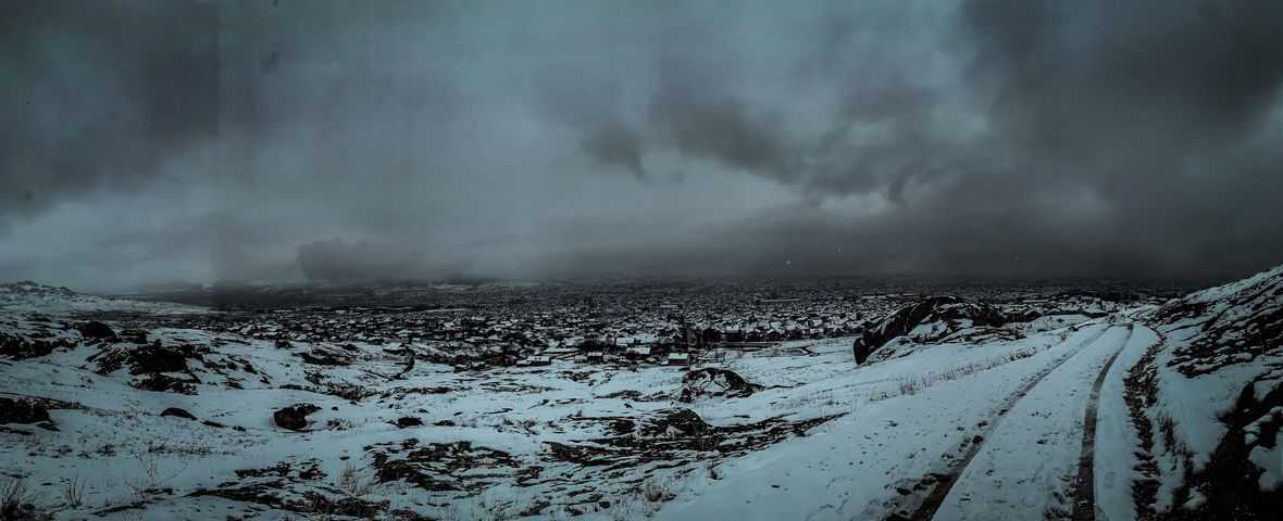
TxGal
Day by day
"Insane depth of cold" to blast Britain [in April], as Sea Ice AT BOTH POLES continues to grow exponentially - Electroverse

“INSANE DEPTH OF COLD” TO BLAST BRITAIN [IN APRIL], AS SEA ICE AT BOTH POLES CONTINUES TO GROW EXPONENTIALLY
MARCH 29, 2021 ADMIN
For something purportedly “global,” AGW sure is illusive…
“INSANE DEPTH OF COLD” TO BLAST BRITAIN
An “insane depth of cold” is set to strike the UK over the Easter weekend, warns the Weather Outlook’s Brian Gaze.
Freezing temperatures and frosts will arrive in Scotland on Thursday, April 1, with “polar spring” conditions engulfing the majority of the country by Good Friday.
Looking further ahead, the mercury is expected to sink even lower during the following week, as a violent kink in the jet stream (associated with the historically low solar activity we continue to experience) delivers Arctic air to the lower-latitudes.
Thermometers could sink to -10C (14F) in northern parts, which would topple all-time daily cold records.
The UK’s lowest-ever recorded temperature for April 5, for example, is the -9C (15.8F) set in 1990, while 1935’s -8.9C (16F) for April 7 could also tumble. In fact, most of the daily benchmarks between early-to-mid April are under threat, including some that have stood for more than a century.
What’s about the hit the UK (as well as western/northern Europe) looks unprecedented, and it’s arriving during a key time of the growing season, too — expect significant crop losses moving forward.
The freezing conditions aren’t fleeting either (unlike the two days of warmth on Mon and Tue); no, the Arctic looks set to park itself anomalously-far south for at least the first-half of April, with latest GFS runs revealing temps will only drop further as the month progresses.
April 13 (shown below) appears particularly cold, with -10C (14F) again possible in northern parts–a reading that would break the UK’s coldest-ever temperature for the date, which stands as the -9.2C (15.4F) set way back in 1890 (note: this particular forecast is a way off, we’ll have to wait and see if it materializes).

GFS 2m Temp Anomalies for April 13 [tropicaltidbits.com].
Record out–of-season snow is expected to accompany the cold, across Europe:

GFS Total Snowfall March 29 to April 14 [tropicaltidbits.com].
This is April, right?
SEA ICE AT BOTH POLES CONTINUES TO GROW EXPONENTIALLY
Antarctic sea ice fell to a “record minimum” in 2017 –after having reached a “record high” in 2015– but has been on something of a surge ever-since — a fact the AGW cabal is having an impossible time explaining.
Modern climate science states that “because the Earth’s polar regions are warming more quickly than the rest of the world, the temperature contrast that drives jet streams has decreased” which makes for a wavy jet stream flow. But in reality, satellite data reveals that sea ice extent around the southern pole has actually GROWN over the past 40+years, and also shows that temperatures across the continent have had no real trend.
According to the AGW cabal’s ‘Polar Amplification’ theory, Antarctica should be mirroring the trends seen in the Arctic: i.e., warming global temperatures should be melting sea ice exposing the darker sea beneath, absorbing the heat and increasing temperatures. But, as hinted at above, this simply isn’t happening; furthermore, polar outbreaks in the southern hemisphere (aka a weak and wavy jet stream flow) are also on the increase, just as they are in its northern counterpart.
Therefore, there must be an alternative explanation.
And our supposition is that it’s the Sun what’s doing it.
By the way, Arctic sea ice volume (or ‘thickness’) is also doing just fine this year:

Embedded below is the latest data from the National Snow and Ice Data Center (NSIDC).
It shows that sea ice at the South Pole has been on overdrive this season, climbing some 500,000 sq km above the mean. The chart also reveals this year’s growth is comfortably outstripping all four multidecadal averages: 1979 to 1990, 1991 to 2000, 2001 to 2010, and 2011 to 2020:

[NSIDC].
Four years ago, during late-March of 2017, Antarctic sea ice measured 3 million sq km, and now today, during late-March of 2021, measurements have reached 5+ million sq km –this fact is an impossibility under the global warming theory, yet here we are– and for those incapable of running the math for themselves, namely the useful idiots of the AGW Party, that’s an increase of 2 million sq km.
To finish, here’s the March 27, 2021 satellite photo of Antarctica.
The gains are clear to see, particularly around the SW.

[NSIDC]
For good measure, I’ve also included the latest satellite image of Arctic sea ice extent:

[NSIDC]
This, after 4+ decades of being told Arctic ice is on the verge of a catastrophic tipping point, is the state of play — that orange line of extent is close enough to the 1981-2010 median to be statistically irrelevant.
Furthermore, the gains witnessed across Antarctica easily offset the “missing” ice in and around the Arctic; but now, let’s not to fall into the trap of applying logic, that’s a censorable offense these days.
The COLD TIMES are returning, the mid-latitudes are REFREEZING in line with the great conjunction, historically low solar activity, cloud-nucleating Cosmic Rays, and a meridional jet stream flow (among other forcings).
Both NOAA and NASA appear to agree, if you read between the lines, with NOAA saying we’re entering a ‘full-blown’ Grand Solar Minimum in the late-2020s, and NASA seeing this upcoming solar cycle (25) as “the weakest of the past 200 years”, with the agency correlating previous solar shutdowns to prolonged periods of global cooling here.
Furthermore, we can’t ignore the slew of new scientific papers stating the immense impact The Beaufort Gyre could have on the Gulf Stream, and therefore the climate overall.
Prepare accordingly— learn the facts, relocate if need be, and grow your own.
TheSearcher
Are you sure about that?
The Freepers were just talking about the info on the previous post, and someone commented:

The "global warming" at the Equator is sucking all the heat from the poles.
TheSearcher
Are you sure about that?
Alright. Folks, please go look at the Iceland Volcano live stream:
View: https://www.youtube.com/watch?v=BA-9QzIcr3c
What in the heck are the blue lights I see? Car headlights, people with flashlights, what?
What in the heck are the blue lights I see? Car headlights, people with flashlights, what?