
You are using an out of date browser. It may not display this or other websites correctly.
You should upgrade or use an alternative browser.
You should upgrade or use an alternative browser.
Solar Grand Solar Minimum part deux
- Thread starter Dennis Olson
- Start date
-
- Tags
- grand solar minimum

northern watch
TB Fanatic
northern watch
TB Fanatic
northern watch
TB Fanatic
Martinhouse
Deceased
Kim99, I found the website and bookmarked it. Thanks again.
Martinhouse
Deceased
Not seeing TxGal here this morning. Going by what I saw on the radar map, her area really got clobbered by the icy part of this latest storm and I suspect she will be out of power for a good while.
opinions are all over the place.is this minimum supposed to last 5 years, 10 years, 50 years, or 100 years.
is there any agreement on the time span?
from one cycle of 25-40 years to 10,000 years with multiple interacting and reinforcing cycles
the russian sci establishment is pretty much set on the lower range. for now.
northern watch
TB Fanatic
New Winter Storm Threatens Fragile Electrical Grids in Texas, Other Parts of U.S. Second storm will prolong icy conditions for many already struggling with snow and extreme temperatures
Wednesday, February 17, 2021, 1:58 PM ET
By Talal Ansari and Katherine Blunt
Wall Street Journal
Millions of Americans remained without power for a third consecutive day, as another winter storm began blanketing parts of the South with more snow and freezing rain.
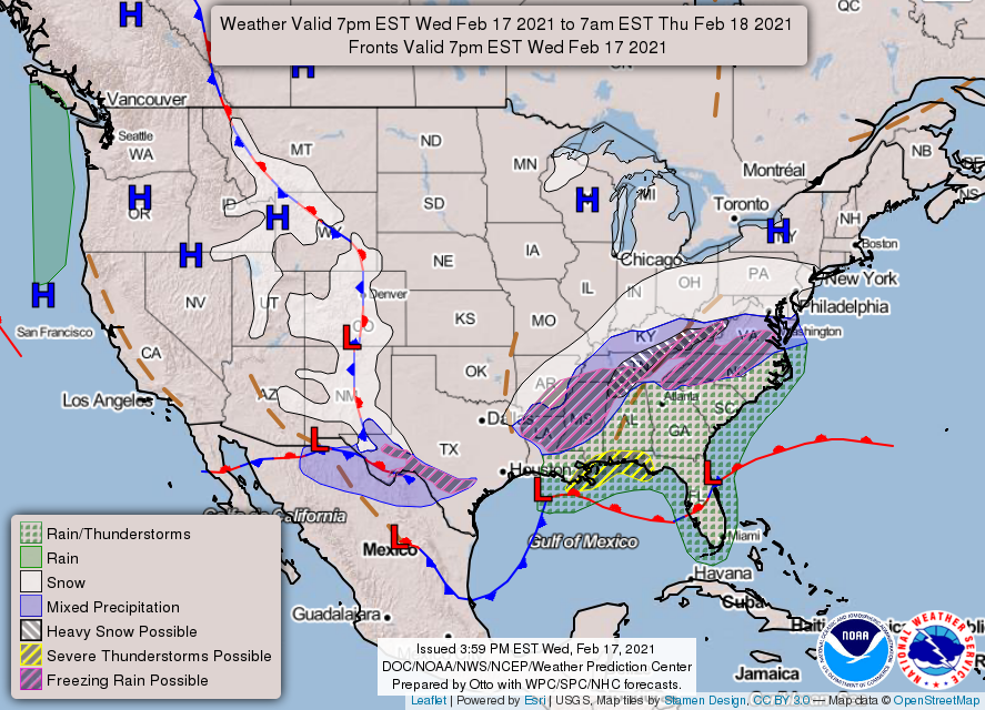
The new storm, which will move toward the East Coast later this week, will prolong icy conditions in some areas hit earlier this week by an Arctic blast of subzero temperatures and snow, according to the National Weather Service's Weather Prediction Center.
Predictions show snowfall of four inches and above from Oklahoma to the mid-Atlantic region, with Pennsylvania potentially seeing eight inches or more later this week. "Significant freezing rain is also likely from Texas to Tennessee and North Carolina to Virginia," the weather service said on Twitter , adding that parts of Texas, Mississippi and the Mid-Atlantic could accumulate swaths of ice a half-inch thick.
Hazardous weather will move into the Florida panhandle and the Carolinas on Thursday, including the possibility of tornadoes, the NWS warned.
The freezing conditions have strained electrical grids across the U.S., and left millions of people without power . At least 20 people have died due to weather-related issues, according to the Associated Press.
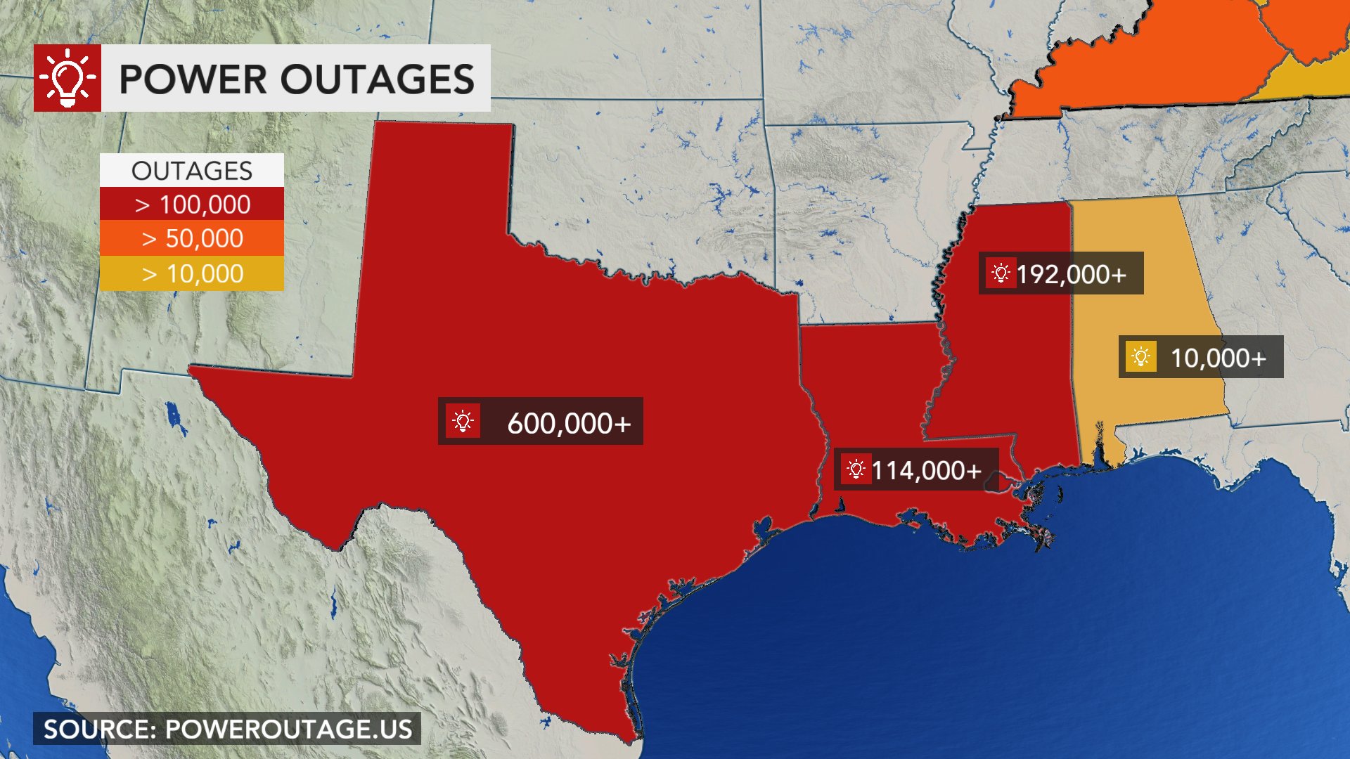
In Texas, where extreme temperatures have broken decadelong records in multiple cities, about 2.8 million households remain without power ahead of the next storm, according to the state's utility.
The Electric Reliability Council of Texas , which operates the state's electricity grid, said it directed electricity providers to restore enough power to supply about 600,000 households on Tuesday evening. The grid operator managed to restore some balance to the system overnight, but lost the ability to import power from the Midwest as demand there surged amid the cold spell.
"We know millions of people are suffering," Ercot Chief Executive Bill Magness said in a statement. "We have no other priority than getting them electricity. No other priority."
About 185 generation units have tripped offline in Texas, the grid operator said.
CenterPoint Energy Inc ., a utility that supplies electricity in the Houston area, said about 1.39 million customers were without power Wednesday morning.
Austin Energy, the city's community-owned electric utility, said the city is facing "two emergency events," namely, that the utility company is continuing outages to help maintain Texas' broader statewide electric grid and that ice storms are causing further outages.
Storm Damage
* Power Outages Drag Into Third Day
* Why Is Texas Experiencing Power Outages?
* Texas Winter Storm Strikes Chip Makers, Compounding Supply Woes
* Insurance Payouts Will Hinge on Policy Details
* Livestock Industry Reels From Storm
* Heard on the Street: Don't Blame Wind for Texas Woes
* Prep Your Tech for Energy Blackouts
"Customers should be prepared to not have power through Wednesday and possibly longer," Austin Energy said in a statement.
Outside of Texas, hundreds of thousands were without electricity for most of Monday and Tuesday.
In Oregon, where Gov. Kate Brown declared a state of emergency over the weekend following heavy snow in parts of the state, more than 150,000 customers remained without electricity, according to poweroutage.us . Other states, including Kentucky, West Virginia, Ohio, Virginia, Louisiana and Mississippi, were also experiencing outages.
In Nebraska, temperatures hit near-record lows in some places. Nebraska Public Power District , which supplies power to most of the state, said early Wednesday it would move to its highest emergency level, which would include planned blackouts. Later, the utility said it would stay at level 2.
"We have been able to avoid service interruptions this morning, but things may change quickly," the company said, adding that the next few hours were critical. On Tuesday, Lincoln recorded its second-coldest temperature on record at -31°F, according to the National Weather Service in Omaha.
The previous and coming storms have also disrupted the country's vaccination program, with Covid-19 testing and vaccination sites in numerous states closed Tuesday and into Wednesday. Shipments of the vaccine have also been delayed, according to the Centers for Disease Control and Prevention .
The CDC is anticipating widespread delays, as bad weather affects deliveries out of vaccine shipping hubs in Memphis, Tenn., and Louisville, Ky., said Jasmine Reed, an agency spokeswoman. "Shipping partners are working to deliver vaccine where possible, contingent on local conditions," Ms. Reed said.
New York City Mayor Bill de Blasio said Wednesday the storm delay in vaccine shipments had led the city to postpone scheduling 30,000 new appointments or more.
The Texas Department of State Health Services said Wednesday that 35,000 doses of the Pfizer vaccine were sent to eight providers in North Texas, but their arrival depends on weather conditions. There were no shipments of the Moderna vaccine, the department said.
"Postponed vaccinations will resume as soon as it is safe," the department said. "No one wants to put vaccine at risk by attempting to deliver it in dangerous conditions."
Write to Talal Ansari at Talal.Ansari@wsj.com and Katherine Blunt at Katherine.Blunt@wsj.com
New Winter Storm Threatens Fragile Electrical Grids in Texas, Other Parts of U.S. - WSJ
Wednesday, February 17, 2021, 1:58 PM ET
By Talal Ansari and Katherine Blunt
Wall Street Journal
Millions of Americans remained without power for a third consecutive day, as another winter storm began blanketing parts of the South with more snow and freezing rain.
The new storm, which will move toward the East Coast later this week, will prolong icy conditions in some areas hit earlier this week by an Arctic blast of subzero temperatures and snow, according to the National Weather Service's Weather Prediction Center.
Predictions show snowfall of four inches and above from Oklahoma to the mid-Atlantic region, with Pennsylvania potentially seeing eight inches or more later this week. "Significant freezing rain is also likely from Texas to Tennessee and North Carolina to Virginia," the weather service said on Twitter , adding that parts of Texas, Mississippi and the Mid-Atlantic could accumulate swaths of ice a half-inch thick.
Hazardous weather will move into the Florida panhandle and the Carolinas on Thursday, including the possibility of tornadoes, the NWS warned.
The freezing conditions have strained electrical grids across the U.S., and left millions of people without power . At least 20 people have died due to weather-related issues, according to the Associated Press.
In Texas, where extreme temperatures have broken decadelong records in multiple cities, about 2.8 million households remain without power ahead of the next storm, according to the state's utility.
The Electric Reliability Council of Texas , which operates the state's electricity grid, said it directed electricity providers to restore enough power to supply about 600,000 households on Tuesday evening. The grid operator managed to restore some balance to the system overnight, but lost the ability to import power from the Midwest as demand there surged amid the cold spell.
"We know millions of people are suffering," Ercot Chief Executive Bill Magness said in a statement. "We have no other priority than getting them electricity. No other priority."
About 185 generation units have tripped offline in Texas, the grid operator said.
CenterPoint Energy Inc ., a utility that supplies electricity in the Houston area, said about 1.39 million customers were without power Wednesday morning.
Austin Energy, the city's community-owned electric utility, said the city is facing "two emergency events," namely, that the utility company is continuing outages to help maintain Texas' broader statewide electric grid and that ice storms are causing further outages.
Storm Damage
* Power Outages Drag Into Third Day
* Why Is Texas Experiencing Power Outages?
* Texas Winter Storm Strikes Chip Makers, Compounding Supply Woes
* Insurance Payouts Will Hinge on Policy Details
* Livestock Industry Reels From Storm
* Heard on the Street: Don't Blame Wind for Texas Woes
* Prep Your Tech for Energy Blackouts
"Customers should be prepared to not have power through Wednesday and possibly longer," Austin Energy said in a statement.
Outside of Texas, hundreds of thousands were without electricity for most of Monday and Tuesday.
In Oregon, where Gov. Kate Brown declared a state of emergency over the weekend following heavy snow in parts of the state, more than 150,000 customers remained without electricity, according to poweroutage.us . Other states, including Kentucky, West Virginia, Ohio, Virginia, Louisiana and Mississippi, were also experiencing outages.
In Nebraska, temperatures hit near-record lows in some places. Nebraska Public Power District , which supplies power to most of the state, said early Wednesday it would move to its highest emergency level, which would include planned blackouts. Later, the utility said it would stay at level 2.
"We have been able to avoid service interruptions this morning, but things may change quickly," the company said, adding that the next few hours were critical. On Tuesday, Lincoln recorded its second-coldest temperature on record at -31°F, according to the National Weather Service in Omaha.
The previous and coming storms have also disrupted the country's vaccination program, with Covid-19 testing and vaccination sites in numerous states closed Tuesday and into Wednesday. Shipments of the vaccine have also been delayed, according to the Centers for Disease Control and Prevention .
The CDC is anticipating widespread delays, as bad weather affects deliveries out of vaccine shipping hubs in Memphis, Tenn., and Louisville, Ky., said Jasmine Reed, an agency spokeswoman. "Shipping partners are working to deliver vaccine where possible, contingent on local conditions," Ms. Reed said.
New York City Mayor Bill de Blasio said Wednesday the storm delay in vaccine shipments had led the city to postpone scheduling 30,000 new appointments or more.
The Texas Department of State Health Services said Wednesday that 35,000 doses of the Pfizer vaccine were sent to eight providers in North Texas, but their arrival depends on weather conditions. There were no shipments of the Moderna vaccine, the department said.
"Postponed vaccinations will resume as soon as it is safe," the department said. "No one wants to put vaccine at risk by attempting to deliver it in dangerous conditions."
Write to Talal Ansari at Talal.Ansari@wsj.com and Katherine Blunt at Katherine.Blunt@wsj.com
New Winter Storm Threatens Fragile Electrical Grids in Texas, Other Parts of U.S. - WSJ
northern watch
TB Fanatic
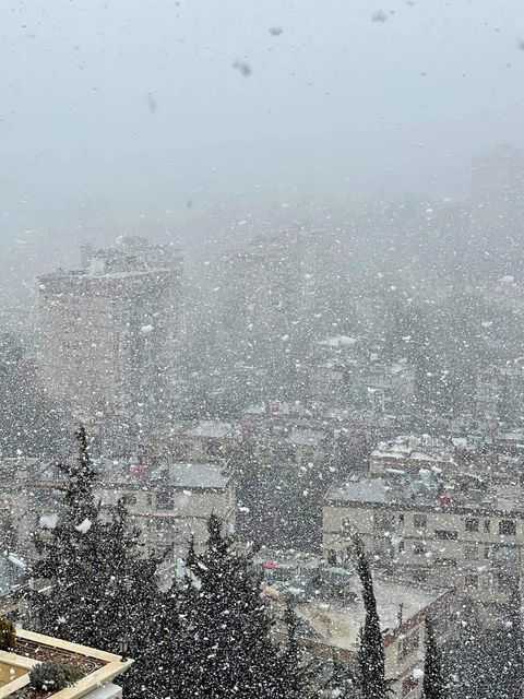
Snowstorms hit East Med, army called out in Greece
Greece has called in the armed forces to help repair widespread damage caused by heavy snowfall in Athens, while blizzards continued to cause havoc in neighboring Turkey and with the snow reaching as far as Libya
By DEREK GATOPOULOS and SUZAN FRASER Associated Press
17 February 2021, 11:11

 The Associated Press
The Panathenian stadium, where the first modern Olympics were held in 1896, is covered with snow after heavy snowfall in Athens, Wednesday, Feb. 17, 2021. Greece has called in the armed forces to help cope with the damage caused heavy snowfall that has left parts of greater Athens without power and water for up to three days. (Antonis Nikolopoulos/Eurokinissi via AP)
Greece called in the armed forces Wednesday to help repair widespread damage caused by heavy snowfall in Athens, while blizzards continued to cause havoc in neighboring Turkey and with the snow reaching as far as Libya.
The Athens snowstorm, described by authorities as the most severe in 40 years, blanketed the city and its ancient monuments Tuesday and left parts of the capital without power and water.
Armed forces service members, including marines, used cranes and chain saws to help fire crews clear hundreds of downed trees that damaged the electricity network and blocked roads.
More than 800 fallen trees in greater Athens struck power lines, and hundreds more were reported in nearby areas including the island of Evia off the coast of the southeast mainland.
“The main challenge now is to restore the power supply to homes. This storm caused problems around the country,” Civil Protection chief Nikos Hardalias said.
“In Evia alone, 500 damaged electricity posts and pylons were replaced. The army and crews from civilian agencies worked through the night and are continuing to work now.”
Later authorities said power had been restored to about 45,000 households on the outskirts of Athens since Wednesday morning, leaving about 25,000 without, and efforts were being redoubled to reconnect them.
Weather conditions improved in Greece Wednesday but continued to cause extensive problems to the east, in Turkey, where blizzards continued to sweep across northern parts of the country as the cold front made its way across the eastern Mediterranean. Snow reached an area in northeastern Libya for the first time in 15 years, and a snowstorm caused road closures in northern Syria.
In Istanbul, Turkey’s largest city, icy roads caused multiple car accidents and authorities said up to 50 centimeters (some 20 inches) of snow has accumulated in the metropolis’ higher-altitude districts.
Elsewhere in Turkey, 22 people were injured after a passenger bus slid off a highway in the central province of Aksaray and overturned, the state-run Anadolu Agency reported.
Heavy snowfall also closed highways and access to dozens of villages in eastern Turkey and closed schools recently reopened due to pandemic restrictions.
———
Fraser reported from Ankara, Turkey
———
Follow Gatopoulos at https://twitter.com/dgatopoulos and Fraser at https://twitter.com/suzanfraser
Snowstorms hit East Med, army called out in Greece - ABC News (go.com)
Greece has called in the armed forces to help repair widespread damage caused by heavy snowfall in Athens, while blizzards continued to cause havoc in neighboring Turkey and with the snow reaching as far as Libya
By DEREK GATOPOULOS and SUZAN FRASER Associated Press
17 February 2021, 11:11
The Panathenian stadium, where the first modern Olympics were held in 1896, is covered with snow after heavy snowfall in Athens, Wednesday, Feb. 17, 2021. Greece has called in the armed forces to help cope with the damage caused heavy snowfall that has left parts of greater Athens without power and water for up to three days. (Antonis Nikolopoulos/Eurokinissi via AP)
Greece called in the armed forces Wednesday to help repair widespread damage caused by heavy snowfall in Athens, while blizzards continued to cause havoc in neighboring Turkey and with the snow reaching as far as Libya.
The Athens snowstorm, described by authorities as the most severe in 40 years, blanketed the city and its ancient monuments Tuesday and left parts of the capital without power and water.
Armed forces service members, including marines, used cranes and chain saws to help fire crews clear hundreds of downed trees that damaged the electricity network and blocked roads.
More than 800 fallen trees in greater Athens struck power lines, and hundreds more were reported in nearby areas including the island of Evia off the coast of the southeast mainland.
“The main challenge now is to restore the power supply to homes. This storm caused problems around the country,” Civil Protection chief Nikos Hardalias said.
“In Evia alone, 500 damaged electricity posts and pylons were replaced. The army and crews from civilian agencies worked through the night and are continuing to work now.”
Later authorities said power had been restored to about 45,000 households on the outskirts of Athens since Wednesday morning, leaving about 25,000 without, and efforts were being redoubled to reconnect them.
Weather conditions improved in Greece Wednesday but continued to cause extensive problems to the east, in Turkey, where blizzards continued to sweep across northern parts of the country as the cold front made its way across the eastern Mediterranean. Snow reached an area in northeastern Libya for the first time in 15 years, and a snowstorm caused road closures in northern Syria.
In Istanbul, Turkey’s largest city, icy roads caused multiple car accidents and authorities said up to 50 centimeters (some 20 inches) of snow has accumulated in the metropolis’ higher-altitude districts.
Elsewhere in Turkey, 22 people were injured after a passenger bus slid off a highway in the central province of Aksaray and overturned, the state-run Anadolu Agency reported.
Heavy snowfall also closed highways and access to dozens of villages in eastern Turkey and closed schools recently reopened due to pandemic restrictions.
———
Fraser reported from Ankara, Turkey
———
Follow Gatopoulos at https://twitter.com/dgatopoulos and Fraser at https://twitter.com/suzanfraser
Snowstorms hit East Med, army called out in Greece - ABC News (go.com)
Last edited:
northern watch
TB Fanatic
Heavy snowfall, gales as winter storm hits Middle East
Snow is blanketing parts of Syria, Lebanon and Israel, blocking roads, disrupting traffic and even delaying exams at some universities
By SARAH EL DEEB Associated Press
17 February 2021, 12:34
")
The Associated Press
An old mobile artillery piece form Mideast wars sits covered with snow in a memorial site near the Quneitra border crossing between Syria and the Israeli-controlled Golan Heights Wednesday, Feb. 17, 2021. (AP Photo/Ariel Schalit)
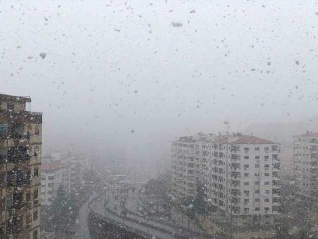
BEIRUT -- Snow blanketed parts of Syria, Lebanon, Jordan and Israel on Wednesday, covering areas it has not reached in years, disrupting traffic and postponing vaccination campaigns against COVID-19 and even exams at some universities.
It snowed for the first time in years in Marjayoun in southern Lebanon, and in Bayda in northeast Libya.
Gale force winds knocked out electricity in vast parts of Lebanon, forcing many Lebanese, already used to power cuts, to rely on generators for longer hours. Rescuers pulled four motorists out of their snow-covered cars, the National News Agency said.
The first snow this winter in the Syrian capital, Damascus, did not prevent the Premier League soccer tournament from going ahead, as Army Sports Club and Al-Karamah faced off despite the snow that covered the pitch, the Syrian Al-Watan daily reported .
In the mountains of Syria's Sweida province, snow was as high as 15 cm (6 inches), according to the official state news agency SANA. Roads in some provinces were blocked. In the central province of Hama, bulldozers shoveled snow to open roads while vehicles skidded on ice, causing traffic disruption.
The University of Damascus called off mid-term exams scheduled for Wednesday and Thursday in all its branches around Syria because of the extreme weather conditions. The country’s ports remained open. Later, local authorities in the provinces of Sweida, Quneitra, Daraa and Tartous suspend school on Thursday due to the storm and heavy snowfall.
In the opposition-held northwestern Syria, civil defense teams have been building dirt mounds since Tuesday around camps for the displaced to prevent rain from flooding the crowded areas. Nearly 3 million displaced people live in northwestern Syria, mostly in tents and temporary shelters. Heavy rainfall last month damaged over 190 displacement sites, destroying and damaging over 10,000 tents.
In neighboring Lebanon, Storm Joyce hit late Tuesday with gale force winds registering between 85 km/h (52 miles/h) and 100 km/h (62 miles/h). The storm is expected to get stronger Thursday.
Breaking a warm spell, the storm brought heavy rainfall, a sharp drop in temperatures and the heaviest snow fall in Lebanon this year. Snow is expected to cover areas of altitudes as low as 400 meters, according to the meteorological department. Nearly a dozen roads in eastern and northern Lebanon were closed to traffic because of the snow. A beachside club and restaurant were submerged in water as waves nearly 4 meters (13 feet) high slammed onto the shore.
The Israeli Meteorological Service forecast heavy thunderstorms and cold temperatures across much of the country, with snowfall at higher altitudes expected later on Wednesday, including in Jerusalem. On Wednesday night, Israeli police closed the main road between Tel Aviv and Jerusalem due to snow.
Heavy snowfall covered the Israeli-annexed Golan Heights near the border with Syria.
In Jordan, the COVID-19 vaccination drive was suspended due to severe weather conditions. Schools and universities also put off classes. Jordan’s Prime Minister Bishr al-Khasawneh announced that Thursday will be an official holiday for both the public and private sector due to the snow storm.
Osama al-Tarifi, director of the operating room of the Arabia Weather site, said snow has reached 20 cm (8 inches) in the mountains of Ajloun in northern Jordan, where snowfall has been non-stop since Tuesday night. Heavy snow is expected in the capital, Amman, on Wednesday.
Wind exceeded 100 km/hour (62 miles/h) in some areas in Jordan.
In Libya, snow blanketed the country's northeast mountains as snowfall continued since Tuesday, covering forests and roads in some areas in the North African country.
Residents of the Jabal al-Akhdar area in the far northeast part of Libya took their children out for fun, some making snowmen and others starting snowball fights.
“I was surprised, actually, by the number of families who came here to take pictures to remember the snow," said Ali al-Shairi, an amateur photographer from the eastern city of Bayda, which is known for recurrent snow in Libya but has not seen any for a couple of years.
In neighboring Egypt, heavy rain and windy weather prevailed on Wednesday and was expected to last into Thursday, the country’s meteorological agency said. Authorities in South Sinai province, which includes touristic hubs, canceled touristic activities, including safaris and cruises to weather the storm.
———
Associated Press writers Omar Akour in Amman, Jordan; Samy Magdy in Cairo; and Isaac Scharf and Ilan Ben Zion in Jerusalem contributed to this report.
Heavy snowfall, gales as winter storm hits Middle East - ABC News (go.com)
Snow is blanketing parts of Syria, Lebanon and Israel, blocking roads, disrupting traffic and even delaying exams at some universities
By SARAH EL DEEB Associated Press
17 February 2021, 12:34
An old mobile artillery piece form Mideast wars sits covered with snow in a memorial site near the Quneitra border crossing between Syria and the Israeli-controlled Golan Heights Wednesday, Feb. 17, 2021. (AP Photo/Ariel Schalit)
BEIRUT -- Snow blanketed parts of Syria, Lebanon, Jordan and Israel on Wednesday, covering areas it has not reached in years, disrupting traffic and postponing vaccination campaigns against COVID-19 and even exams at some universities.
It snowed for the first time in years in Marjayoun in southern Lebanon, and in Bayda in northeast Libya.
Gale force winds knocked out electricity in vast parts of Lebanon, forcing many Lebanese, already used to power cuts, to rely on generators for longer hours. Rescuers pulled four motorists out of their snow-covered cars, the National News Agency said.
The first snow this winter in the Syrian capital, Damascus, did not prevent the Premier League soccer tournament from going ahead, as Army Sports Club and Al-Karamah faced off despite the snow that covered the pitch, the Syrian Al-Watan daily reported .
In the mountains of Syria's Sweida province, snow was as high as 15 cm (6 inches), according to the official state news agency SANA. Roads in some provinces were blocked. In the central province of Hama, bulldozers shoveled snow to open roads while vehicles skidded on ice, causing traffic disruption.
The University of Damascus called off mid-term exams scheduled for Wednesday and Thursday in all its branches around Syria because of the extreme weather conditions. The country’s ports remained open. Later, local authorities in the provinces of Sweida, Quneitra, Daraa and Tartous suspend school on Thursday due to the storm and heavy snowfall.
In the opposition-held northwestern Syria, civil defense teams have been building dirt mounds since Tuesday around camps for the displaced to prevent rain from flooding the crowded areas. Nearly 3 million displaced people live in northwestern Syria, mostly in tents and temporary shelters. Heavy rainfall last month damaged over 190 displacement sites, destroying and damaging over 10,000 tents.
In neighboring Lebanon, Storm Joyce hit late Tuesday with gale force winds registering between 85 km/h (52 miles/h) and 100 km/h (62 miles/h). The storm is expected to get stronger Thursday.
Breaking a warm spell, the storm brought heavy rainfall, a sharp drop in temperatures and the heaviest snow fall in Lebanon this year. Snow is expected to cover areas of altitudes as low as 400 meters, according to the meteorological department. Nearly a dozen roads in eastern and northern Lebanon were closed to traffic because of the snow. A beachside club and restaurant were submerged in water as waves nearly 4 meters (13 feet) high slammed onto the shore.
The Israeli Meteorological Service forecast heavy thunderstorms and cold temperatures across much of the country, with snowfall at higher altitudes expected later on Wednesday, including in Jerusalem. On Wednesday night, Israeli police closed the main road between Tel Aviv and Jerusalem due to snow.
Heavy snowfall covered the Israeli-annexed Golan Heights near the border with Syria.
In Jordan, the COVID-19 vaccination drive was suspended due to severe weather conditions. Schools and universities also put off classes. Jordan’s Prime Minister Bishr al-Khasawneh announced that Thursday will be an official holiday for both the public and private sector due to the snow storm.
Osama al-Tarifi, director of the operating room of the Arabia Weather site, said snow has reached 20 cm (8 inches) in the mountains of Ajloun in northern Jordan, where snowfall has been non-stop since Tuesday night. Heavy snow is expected in the capital, Amman, on Wednesday.
Wind exceeded 100 km/hour (62 miles/h) in some areas in Jordan.
In Libya, snow blanketed the country's northeast mountains as snowfall continued since Tuesday, covering forests and roads in some areas in the North African country.
Residents of the Jabal al-Akhdar area in the far northeast part of Libya took their children out for fun, some making snowmen and others starting snowball fights.
“I was surprised, actually, by the number of families who came here to take pictures to remember the snow," said Ali al-Shairi, an amateur photographer from the eastern city of Bayda, which is known for recurrent snow in Libya but has not seen any for a couple of years.
In neighboring Egypt, heavy rain and windy weather prevailed on Wednesday and was expected to last into Thursday, the country’s meteorological agency said. Authorities in South Sinai province, which includes touristic hubs, canceled touristic activities, including safaris and cruises to weather the storm.
———
Associated Press writers Omar Akour in Amman, Jordan; Samy Magdy in Cairo; and Isaac Scharf and Ilan Ben Zion in Jerusalem contributed to this report.
Heavy snowfall, gales as winter storm hits Middle East - ABC News (go.com)
northern watch
TB Fanatic
northern watch
TB Fanatic


northern watch
TB Fanatic

northern watch
TB Fanatic
Green Folly: Berlin city's e-buses ground to halt due cold weather
P. Gosselin
No Tricks Zone
Wed, 17 Feb 2021 19:44 UTC
Germany's capital Berlin was forced to replace some of its electric buses with diesel buses due to range problems associated with the cold weather.

© Robert Radke, CC BY-SA 4.0
Berlin. Germany’s fleet of e-buses had a hard time coping with the recent cold weather as dozens had to be replaced by diesel powered buses.
The cold weather worldwide is exposing the weakness of green energies and transportation systems based on them. For example Texas has seen millions of people impacted by rolling blackouts due to solar panels being covered by snow and wind turbines being frozen still.
The extremely cold weather has also led to transport disruptions all over Germany. One example is Berlin, Germany's fleet of electric city buses.
23 e-buses had to be taken out of service
The Berliner Morgenpost reported some of the green electric buses operated by the Berliner Verkehrsbetriebe (BVG) had been taken out service due to range problems in the extremely cold weather. Up to 23 electric buses had to be replaced by diesel-powered buses last Monday. Ultimately the German capital plans to convert its entire fleet to electric by 2030.
Hat-tip. Die Welt
According to internal memos provided to the Berliner Morgenpost daily, the very cold temperatures were too much for the electric buses' batteries because so much power was needed for heating. A portion of the electric buses were substituted by diesel buses overnight because they no longer had enough power to complete their planned routes.
BVG spokeswoman Petra Nelken confirmed that the twelve-meter-long Solaris e-bus was not able to cope well with the cold. "According to the procurement contract and the specifications, they are supposed to be able to drive 130 kilometers even at minus 10 degrees Celsius, but not all of them made it," she said.
The inadequate e-buses were replaced by diesel powered buses, which can reliably travel hundreds of kilometers before needing to be refueled.
Altogether 23 buses of the 123 electric bus fleet were taken out of service, thus creating delays and forcing passengers to wait out in the cold at bus stops.
When asked by WELT, Nelken also emphasized that the buses were often not completely out of service, but only had to return to the depot (and to the charging) earlier than usual.
Green Folly: Berlin city's e-buses ground to halt due cold weather -- Earth Changes -- Sott.net
northern watch
TB Fanatic
Snow falls in Libya for the first time in 15 years
Kizzi Asala with AFP
AfricaNews
Wed, 17 Feb 2021 15:22 UTC

The Green Mountain in northeastern Libya was veiled white this week as snow fell in the area for the first time in 15 years.
The rare flurry began on Monday and is expected to continue for at least two more days.
Families from the Sidi Mohamed Al-Hamri area dressed warmly and headed outside for fun-filled snowball fights, to build snowmen, and enjoy the wintry scenery.
Snow and Peace in Libya?
Mohammed Saleh, a Bayda Resident, believes that the snowfall is an omen for peace in the country.
"We hope the snowfall will be a good sign for our homeland by unifying our institutions and unifying our country and for people to return to one another and love each other. As we see now, the children, people and families that came to this area, the area of Sidi Mohamed Al-Hamri."
Ali Al-Shairi, another Bayda Resident, came out to capture the positive energy.
"As an amateur photographer, I came to this place to document the scene, so I was here and actually surprised by the number of families who came here to take pictures in the snow."
According to the Libyan National Meteorological Center, temperatures near and below zero were recorded on Monday in several cities — including Al-Bayda, Yefren, Nalut and Al-Marj, as well as Green Mountain and the Nafusa Mountain.
Snow falls in Libya for the first time in 15 years -- Earth Changes -- Sott.net
Kizzi Asala with AFP
AfricaNews
Wed, 17 Feb 2021 15:22 UTC

The Green Mountain in northeastern Libya was veiled white this week as snow fell in the area for the first time in 15 years.
The rare flurry began on Monday and is expected to continue for at least two more days.
Families from the Sidi Mohamed Al-Hamri area dressed warmly and headed outside for fun-filled snowball fights, to build snowmen, and enjoy the wintry scenery.
Definitely snowing heavily in #Libya .. affecting all segments of daily Life including #Shipping and #Ports operations pic.twitter.com/kI2qc8ABUY
— @MedWave Shipping Libya (@MedWave1) February 16, 2021
Mohammed Saleh, a Bayda Resident, believes that the snowfall is an omen for peace in the country.
"We hope the snowfall will be a good sign for our homeland by unifying our institutions and unifying our country and for people to return to one another and love each other. As we see now, the children, people and families that came to this area, the area of Sidi Mohamed Al-Hamri."
Ali Al-Shairi, another Bayda Resident, came out to capture the positive energy.
"As an amateur photographer, I came to this place to document the scene, so I was here and actually surprised by the number of families who came here to take pictures in the snow."
According to the Libyan National Meteorological Center, temperatures near and below zero were recorded on Monday in several cities — including Al-Bayda, Yefren, Nalut and Al-Marj, as well as Green Mountain and the Nafusa Mountain.
Snow falls in Libya for the first time in 15 years -- Earth Changes -- Sott.net
northern watch
TB Fanatic
northern watch
TB Fanatic

northern watch
TB Fanatic
I think it is something like 25 years. IIRC I figured I would be in my late 60s when it was over. But who knows for sure.
If we get a Maunder Minimum 1645 to 1715 AD, 70 years then we are in for a world of very cold winters and short growing seasons. The Maunder Minimum seems to be the worst of the minimums in terms of length of time 70 years and colder temperatures.


northern watch
TB Fanatic
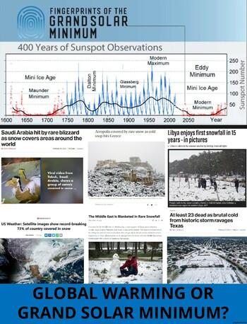
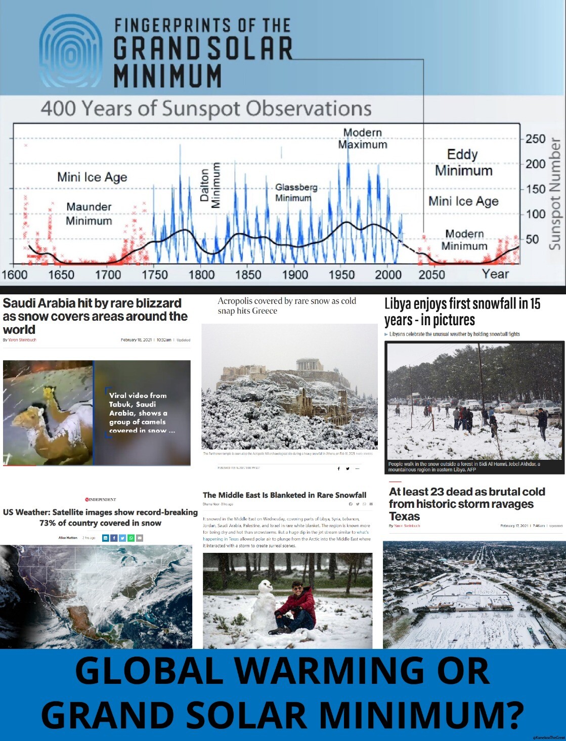
Millions Still Without Power After Deadly Storm - Climate Change or Natural Climate Cycles?
Oppenheimer Ranch Project
Texas: Deaths mount as winter storm leaves millions without power http://bbc.in/3jWHoPW At least 21 dead as brutal cold from historic storm ravages Texas http://bit.ly/2NfR7oH Coleman Says ERCOT Wants the Whole City to Freeze http://bit.ly/3uaImwH Power Outage Live Map https://poweroutage.us/ GFS Model Total Snow Texas http://bit.ly/3s2sZVs GFS Model Temperature Texas http://bit.ly/3pCRcjD Deep freeze sends Texas electricity prices soaring 10,000% http://cnn.it/3k5zhRq How one Texas storm exposed an energy grid unprepared for climate change http://nbcnews.to/3ptSrBt A winter storm caused Texas's power outage. Climate change likely caused the storm http://on.msnbc.com/37ol5h9 Texas knew for years power grid was at risk but did little about it. Unbelievable. http://bit.ly/3auzDxS The Coldest Night in Texas History http://bit.ly/37nretM EXTREME TEXAS WEATHER RECORDS http://bit.ly/3dq8VrQ 400 Years of Sunspot Observations https://bit.ly/3bcbf37
northern watch
TB Fanatic
This is not good, another day without TxGal. I am thinking she is without power!Not seeing TxGal here this morning. Going by what I saw on the radar map, her area really got clobbered by the icy part of this latest storm and I suspect she will be out of power for a good while.
northern watch
TB Fanatic
TxGal
Day by day
Thanks, everyone, so much for your concern!
We were impacted by the rolling outages yesterday, but so far that's it. We have Hughes.net satellite for internet service, and they've been down since the last time I posted. This is the first time they've been back up. From what I can tell, it looked like they have had major outages across the nation. DirecTV has been mostly on, but not all channels - including the Texas-based channels we needed the most for local news. I know many, many people in various areas of the state, and they have had it far worse than we did...for the most part, we had power. The last storm back in January we lost power twice in two days, for 12 hrs plus each time. That was the storm that gave us over 8" of snow.
I have to tell you, I've lived 50 years on the eastern seaboard, mostly in the Northern VA area (Alfaman, I sure hope you're okay), and have been through plenty of Nor'easters (winter hurricanes for those that don't know) that socked us in for a week at a time with feet (plural) of snow. Was there for the blizzards of '66 and '78, etc., and this past week tops them all in terms of impact to our daily lives - and we were very well-prepared. Sleet, freezing rain, and snow...in waves over the span of the week. Every day, sometimes for several days at a stretch with no break between storms.
We have about 5" of snow that is now under 1" plus of ice. No one can go anywhere, we don't get plowed out here in the country. Most of Texas doesn't have much if any road clearing equipment except for the bigger cities. Ditto for road treatment products. Temps dropped to single digits several nights, in the teens for most...20s started to feel warm.
My biggest concern has been livestock (cattle, chickens, and ducks), the septic system, HVAC functioning, and of course our plumbing. We won't know for sure about the pipes until we get a thaw...they seem okay, but we have been through blown pipes before and know what could happen. Septic seems fine. HVAC is now 11 yrs old and I have had concerns, but it performed like a champ...I was out there twice a day with a hair dryer blowing the frost/ice off the condenser.
The cattle concern me the most. We have (had now) a good supply of hay, and have been saving our faucet drip (stream) water to put in tubs for them. We are now a little low on hay but the storm system is almost over. The water refroze in a matter of hours, so it was a constant chore. We relied more on square bales of hay due to ease of putting them out and being able to rotate where we fed. We literally put out squares several times a day - by hand. Biggest concern now is the difficulty the cattle are having walking on the ice covered snow...I just pray we won't have any getting injured...that's often a put down in these conditions. I believe there could be huge loss to livestock from this storm system across the state, and into other livestock states. Chickens/ducks - metal waterers were useless, they froze up and haven't been unfrozen since it all started. Fortunately we also had Fortex bowls on hand (black, kinda like rubber) and they are far easier to work with, both in keeping the water liquid and in getting any frozen water out since they remain flexible but sturdy.
Lots of lessons learned here, and we've been solid preppers all our lives. Still, there's always room for improvement and we already have lists. We'll be working on that right after this event is over and it's warm again.
Thank you all for keeping this thread going!!
Martinhouse
Deceased
TxGal, I'm so glad you guys are okay!
I had only one power outage. I think it was Tuesday morning, and it only lasted five hours. My last space heater is almost shot and I've brought iiiiiin one of the old infrared ones I used three years ago. Nephew has been coming down ecery afternoon and he and his kids have kept my walks shoveled and are doing the feed and water for the chickens and rabbits. H
My back blew out yesterday morning and I can barely move around so nephew said he will help me get the new heater going when he comes down pretty soon.
Back is terribly painful and I sure hope it is something that will heal! Still lots for me to do. I'm not ready to quit!
Be well a;ll of you guys. Tonight is the last extra cold night for my area,\. Great because I am mighty tired of being so cold!
TxGal
Day by day
You're nephew is wonderful!TxGal, I'm so glad you guys are okay!
I had only one power outage. I think it was Tuesday morning, and it only lasted five hours. My last space heater is almost shot and I've brought iiiiiin one of the old infrared ones I used three years ago. Nephew has been coming down ecery afternoon and he and his kids have kept my walks shoveled and are doing the feed and water for the chickens and rabbits. H
My back blew out yesterday morning and I can barely move around so nephew said he will help me get the new heater going when he comes down pretty soon.
Back is terribly painful and I sure hope it is something that will heal! Still lots for me to do. I'm not ready to quit!
Be well a;ll of you guys. Tonight is the last extra cold night for my area,\. Great because I am mighty tired of being so cold!
So sorry about your back, mine is touchy but I can still function.
Tonight is another cold one for us, also, down to 16 I think....then we should be mostly back to normal.
TxGal
Day by day
Major Winter Storm Impacts Southeast Today - Bitter Cold Grips Heartland - Ice Age Now
Major Winter Storm Impacts Southeast Today – Bitter Cold Grips Heartland
February 17, 2021 by Robert
Temperatures still remain 20 to 35 degrees below normal throughout the Plains, Mississippi Valley, and lower Great Lakes.
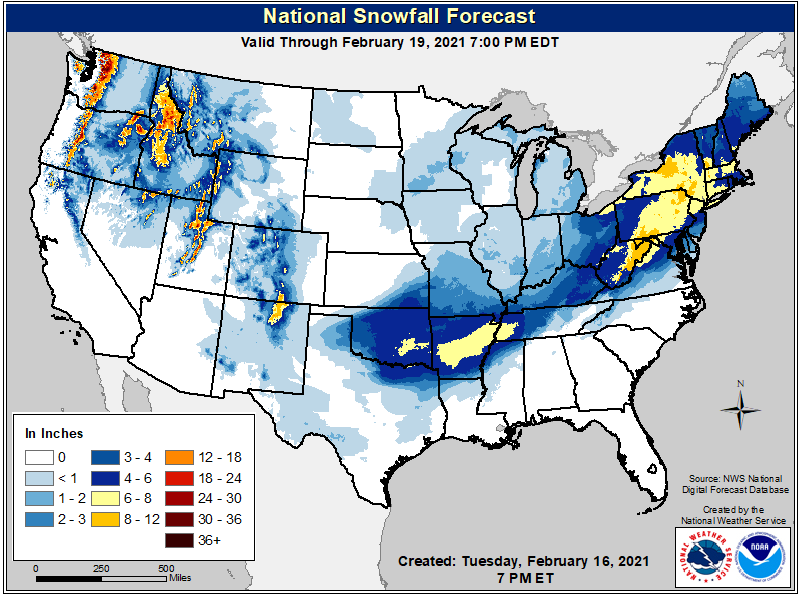
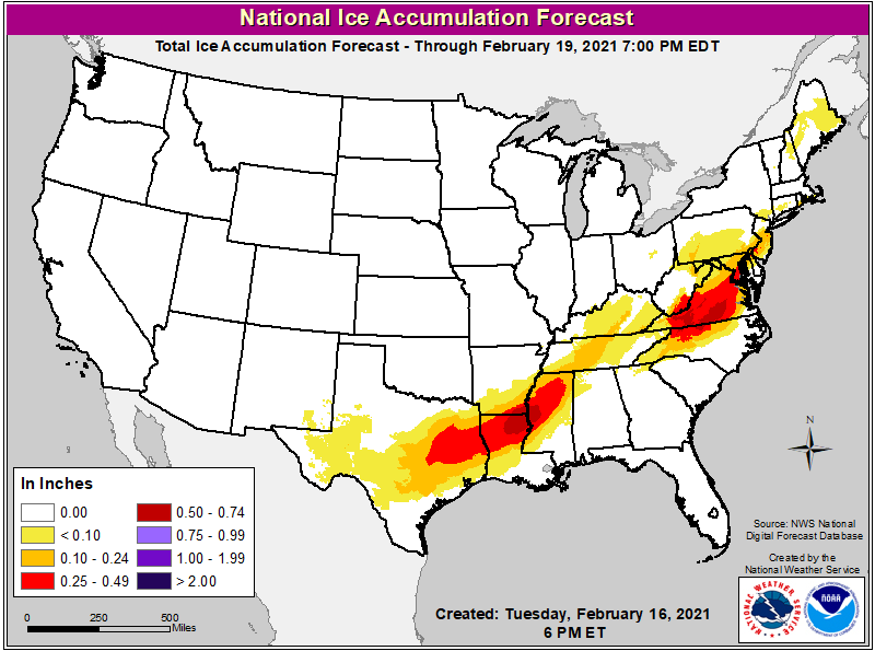
Significant icing and heavy snowfall
A major winter storm will impact the Southeast U.S. today bringing with it significant icing and heavy snowfall. This system will track into the Ohio Valley, Mid-Atlantic, and Northeast U.S. Thursday into Friday, producing similar impacts.
Over 100 million Americans are under Winter Storm Warnings, Winter Storm Watches, or Winter Weather Advisories as another round of impactful winter weather tracks from the Southern Plains to the East Coast…
The developing winter storm to produce heavy snow and treacherous ice accumulations from the South Central U.S. to Mid-Atlantic…
Bitter cold expected to continue. Showers and thunderstorms to track across the Southeast; Pacific storm system ushers in valley/coastal rain and heavy mountain snow to the Northwest.
Areas of snow and freezing rain to envelope much of the South Central U.S. this morning.
The snowfall will extend from Arkansas and the Mid-South to the central Appalachians with accumulations of 3 to 6 inches likely. Heavier amounts over 8 inches are possible in parts of south-central Arkansas.
Just south of the snow zone, significant ice accumulations are expected from east Texas and the Lower Mississippi Valley to the Virginia and North Carolina Piedmont by Wednesday night.
Ice accumulations of a quarter to a half inch are forecast in parts of east Texas, northern Louisiana, southern Arkansas, and western Mississippi with crippling totals over a half inch also possible. The same range of ice accumulations are anticipated in the North Carolina and Virginia Piedmont Wednesday night into Thursday with even some localized amounts as high as three-quarters of an inch.
Dangerous travel, numerous power outages, extensive tree damage
In those areas, residents can expect dangerous travel conditions, numerous power outages, and extensive tree damage. Meanwhile, periods of moderate-to-heavy snow will breakout across the northern Mid-Atlantic Thursday with some locations switching over to sleet and/or freezing rain.
Heavy snow may work its way to southern New England Thursday afternoon into Thursday night. Snowfall totals are subject to how much sleet and freezing rain mixes in, but the sheer amount of wintry precipitation will cause treacherous travel conditions and many travel delays.
As much as a foot (30 cm) of snow in the Appalachians of Virginia and West Virginia
The heaviest snow totals are likely in the Appalachians of Virginia and West Virginia where as much as a foot is possible. In coming days the number of record cold maximum and minimum temperatures will not be as common (the bulk of which are occurring in the South Central U.S.), temperatures will still remain 20 to 35 degrees below normal throughout the Plains, Mississippi Valley, and lower Great Lakes.
Morning lows in the single digits or below zero look to continue both today and Thursday in parts of the Great Plains.
Impending winter storm arrives Thursday morning
Bitter cold has pushed east into the Mid-Atlantic and Northeast ahead of the impending winter storm that arrives Thursday morning. High temperatures will struggle to eclipse the freezing mark both today and Thursday in these regions.
Out West, after a day of tranquil weather on Wednesday, a Pacific storm system ushers in another round of valley/coastal rain and mountain snow on Thursday. Locally heavy rainfall is possible in far northwestern California and far southwestern Oregon on Thursday. Meanwhile, the Cascades are likely to receive another foot of snow with heavy snow working its way into the northern Rockies Thursday night and continuing into Friday morning.
WPC's Short Range Public Discussion
Major Winter Storm Impacts Southeast Today – Bitter Cold Grips Heartland
February 17, 2021 by Robert
Temperatures still remain 20 to 35 degrees below normal throughout the Plains, Mississippi Valley, and lower Great Lakes.
Significant icing and heavy snowfall
A major winter storm will impact the Southeast U.S. today bringing with it significant icing and heavy snowfall. This system will track into the Ohio Valley, Mid-Atlantic, and Northeast U.S. Thursday into Friday, producing similar impacts.
Over 100 million Americans are under Winter Storm Warnings, Winter Storm Watches, or Winter Weather Advisories as another round of impactful winter weather tracks from the Southern Plains to the East Coast…
The developing winter storm to produce heavy snow and treacherous ice accumulations from the South Central U.S. to Mid-Atlantic…
Bitter cold expected to continue. Showers and thunderstorms to track across the Southeast; Pacific storm system ushers in valley/coastal rain and heavy mountain snow to the Northwest.
Areas of snow and freezing rain to envelope much of the South Central U.S. this morning.
The snowfall will extend from Arkansas and the Mid-South to the central Appalachians with accumulations of 3 to 6 inches likely. Heavier amounts over 8 inches are possible in parts of south-central Arkansas.
Just south of the snow zone, significant ice accumulations are expected from east Texas and the Lower Mississippi Valley to the Virginia and North Carolina Piedmont by Wednesday night.
Ice accumulations of a quarter to a half inch are forecast in parts of east Texas, northern Louisiana, southern Arkansas, and western Mississippi with crippling totals over a half inch also possible. The same range of ice accumulations are anticipated in the North Carolina and Virginia Piedmont Wednesday night into Thursday with even some localized amounts as high as three-quarters of an inch.
Dangerous travel, numerous power outages, extensive tree damage
In those areas, residents can expect dangerous travel conditions, numerous power outages, and extensive tree damage. Meanwhile, periods of moderate-to-heavy snow will breakout across the northern Mid-Atlantic Thursday with some locations switching over to sleet and/or freezing rain.
Heavy snow may work its way to southern New England Thursday afternoon into Thursday night. Snowfall totals are subject to how much sleet and freezing rain mixes in, but the sheer amount of wintry precipitation will cause treacherous travel conditions and many travel delays.
As much as a foot (30 cm) of snow in the Appalachians of Virginia and West Virginia
The heaviest snow totals are likely in the Appalachians of Virginia and West Virginia where as much as a foot is possible. In coming days the number of record cold maximum and minimum temperatures will not be as common (the bulk of which are occurring in the South Central U.S.), temperatures will still remain 20 to 35 degrees below normal throughout the Plains, Mississippi Valley, and lower Great Lakes.
Morning lows in the single digits or below zero look to continue both today and Thursday in parts of the Great Plains.
Impending winter storm arrives Thursday morning
Bitter cold has pushed east into the Mid-Atlantic and Northeast ahead of the impending winter storm that arrives Thursday morning. High temperatures will struggle to eclipse the freezing mark both today and Thursday in these regions.
Out West, after a day of tranquil weather on Wednesday, a Pacific storm system ushers in another round of valley/coastal rain and mountain snow on Thursday. Locally heavy rainfall is possible in far northwestern California and far southwestern Oregon on Thursday. Meanwhile, the Cascades are likely to receive another foot of snow with heavy snow working its way into the northern Rockies Thursday night and continuing into Friday morning.
WPC's Short Range Public Discussion
TxGal
Day by day
Libya sees Snow for first time in 15 years, rare flakes also hit Egypt, Syria, Lebanon, Palestine, Israel, Jordan and Saudi Arabia (among others) as the Sun hits milestone of 2 Spotless weeks - Electroverse

LIBYA SEES SNOW FOR FIRST TIME IN 15 YEARS, RARE FLAKES ALSO HIT EGYPT, SYRIA, LEBANON, PALESTINE, ISRAEL, JORDAN AND SAUDI ARABIA (AMONG OTHERS) AS THE SUN HITS MILESTONE OF 2 SPOTLESS WEEKS
FEBRUARY 18, 2021 CAP ALLON
Rare and heavy snow has buried parts of Libya, Egypt, Syria, Lebanon, Palestine, Israel, Jordan and Saudi Arabia (among others) of late, blocking roads and closing schools and businesses.
This week’s disruptive Arctic freeze isn’t just confined to the North America –where on Monday a staggering 79% of the U.S. was below freezing– no, polar cold is engulfing a large portion of the northern hemisphere, including central/eastern Europe, northern/western Asia, north Africa, and the Middle East, and it has succeeded in driving Earth’s temperature below the 1979-2000 average.
As reported by africanews.com, Libya saw its first snowfall in 15 years on Tuesday — the Green Mountain in the northeast if the county was veiled white as snow settled in the area for the first time since 2006:
View: https://twitter.com/MedWave1/status/1361635867819974658
Run time is 1:00
According to the Libyan National Meteorological Center, rare sub-zero temperatures were recorded in several cities — including Al-Bayda, Yefren, Nalut and Al-Marj, as well as Green Mountain and the Nafusa Mountain.
Neighboring Egypt has also been suffering an anomalous freeze of late, with rare snow and ice pellets reported in Alexandria, Beheira, and Port Said. The Egyptian Meteorological Authority (EMA) has urged citizens to exercise caution during this week’s cold wave: “wear extra layers”–superb advice.
Confused camels have been reported in Saudi Arabia:
View: https://twitter.com/Joyce_Karam/status/1362193397856022530
Run time is 0:31
While substantial snow also blanketed parts of Syria, Lebanon and Israel on Wednesday, reports the independent.co.uk.
Syria’s capital Damacus saw impressive totals, while 6+inches (15+cm) was observed in the the mountains of Sweida province, according to the official state news agency SANA.
View: https://twitter.com/ADrockur/status/1362350404089053185
Roads in many Syrian provinces were blocked by drifting snow — in the central province of Hama, bulldozers attempted to reopen stretches while vehicles skidded on ice, causing further traffic disruption.
Some 3 million displaced people live in northwestern Syria, mostly in tents and temporary shelters — the current situation there is akin to hell on Earth.
In nearby Lebanon, Storm Joyce hit late Tuesday bringing with it heavy snowfall to altitudes as low as 1,300 ft (400 m), according to the Meteorological department, which resulted in blocked roads and snarled traffic in eastern and northern parts.
And finally, the Israeli Meteorological Service warned of brutally frigid temperatures across the country on Wednesday, with the first snowfall in two years expected in the old city of Jerusalem by the evening.
That forecast turned out to be accurate –and then some– as rare heavy snow hit the city soon after sundown, resulting in spectacular scenes:
View: https://twitter.com/LedaLidija/status/1362343539028418562
Run time is 0:15
View: https://twitter.com/Ruptly/status/1362333535684546561
Run time is 1:11
View: https://twitter.com/NeriZilber/status/1362335749035741184
Schools across Jerusalem were closed Thursday — an exceptionally rare move.
TWO SPOTLESS WEEKS
At a time when Solar Cycle 25 should be “ramping-up” the Sun has instead been eerily quiet — it has been “blank” (devoid of sunspots) for the past 14 consecutive days (as of Thur, Feb. 18) making for 31 spotless days in 2021, or 63%:

Brace for global cooling and food shortages.
I’m off out to prepare a bed for sorghum.
The COLD TIMES are returning, the mid-latitudes are REFREEZING in line with the great conjunction, historically low solar activity, cloud-nucleating Cosmic Rays, and a meridional jet stream flow (among other forcings).
Both NOAA and NASA appear to agree, if you read between the lines, with NOAA saying we’re entering a ‘full-blown’ Grand Solar Minimum in the late-2020s, and NASA seeing this upcoming solar cycle (25) as “the weakest of the past 200 years”, with the agency correlating previous solar shutdowns to prolonged periods of global cooling here.
Furthermore, we can’t ignore the slew of new scientific papers stating the immense impact The Beaufort Gyre could have on the Gulf Stream, and therefore the climate overall.


Prepare accordingly— learn the facts, relocate if need be, and grow your own.
LIBYA SEES SNOW FOR FIRST TIME IN 15 YEARS, RARE FLAKES ALSO HIT EGYPT, SYRIA, LEBANON, PALESTINE, ISRAEL, JORDAN AND SAUDI ARABIA (AMONG OTHERS) AS THE SUN HITS MILESTONE OF 2 SPOTLESS WEEKS
FEBRUARY 18, 2021 CAP ALLON
Rare and heavy snow has buried parts of Libya, Egypt, Syria, Lebanon, Palestine, Israel, Jordan and Saudi Arabia (among others) of late, blocking roads and closing schools and businesses.
This week’s disruptive Arctic freeze isn’t just confined to the North America –where on Monday a staggering 79% of the U.S. was below freezing– no, polar cold is engulfing a large portion of the northern hemisphere, including central/eastern Europe, northern/western Asia, north Africa, and the Middle East, and it has succeeded in driving Earth’s temperature below the 1979-2000 average.
As reported by africanews.com, Libya saw its first snowfall in 15 years on Tuesday — the Green Mountain in the northeast if the county was veiled white as snow settled in the area for the first time since 2006:
View: https://twitter.com/MedWave1/status/1361635867819974658
Run time is 1:00
According to the Libyan National Meteorological Center, rare sub-zero temperatures were recorded in several cities — including Al-Bayda, Yefren, Nalut and Al-Marj, as well as Green Mountain and the Nafusa Mountain.
Neighboring Egypt has also been suffering an anomalous freeze of late, with rare snow and ice pellets reported in Alexandria, Beheira, and Port Said. The Egyptian Meteorological Authority (EMA) has urged citizens to exercise caution during this week’s cold wave: “wear extra layers”–superb advice.
Confused camels have been reported in Saudi Arabia:
View: https://twitter.com/Joyce_Karam/status/1362193397856022530
Run time is 0:31
While substantial snow also blanketed parts of Syria, Lebanon and Israel on Wednesday, reports the independent.co.uk.
Syria’s capital Damacus saw impressive totals, while 6+inches (15+cm) was observed in the the mountains of Sweida province, according to the official state news agency SANA.
View: https://twitter.com/ADrockur/status/1362350404089053185
Roads in many Syrian provinces were blocked by drifting snow — in the central province of Hama, bulldozers attempted to reopen stretches while vehicles skidded on ice, causing further traffic disruption.
Some 3 million displaced people live in northwestern Syria, mostly in tents and temporary shelters — the current situation there is akin to hell on Earth.
In nearby Lebanon, Storm Joyce hit late Tuesday bringing with it heavy snowfall to altitudes as low as 1,300 ft (400 m), according to the Meteorological department, which resulted in blocked roads and snarled traffic in eastern and northern parts.
And finally, the Israeli Meteorological Service warned of brutally frigid temperatures across the country on Wednesday, with the first snowfall in two years expected in the old city of Jerusalem by the evening.
That forecast turned out to be accurate –and then some– as rare heavy snow hit the city soon after sundown, resulting in spectacular scenes:
View: https://twitter.com/LedaLidija/status/1362343539028418562
Run time is 0:15
View: https://twitter.com/Ruptly/status/1362333535684546561
Run time is 1:11
View: https://twitter.com/NeriZilber/status/1362335749035741184
Schools across Jerusalem were closed Thursday — an exceptionally rare move.
TWO SPOTLESS WEEKS
At a time when Solar Cycle 25 should be “ramping-up” the Sun has instead been eerily quiet — it has been “blank” (devoid of sunspots) for the past 14 consecutive days (as of Thur, Feb. 18) making for 31 spotless days in 2021, or 63%:
Brace for global cooling and food shortages.
I’m off out to prepare a bed for sorghum.
The COLD TIMES are returning, the mid-latitudes are REFREEZING in line with the great conjunction, historically low solar activity, cloud-nucleating Cosmic Rays, and a meridional jet stream flow (among other forcings).
Both NOAA and NASA appear to agree, if you read between the lines, with NOAA saying we’re entering a ‘full-blown’ Grand Solar Minimum in the late-2020s, and NASA seeing this upcoming solar cycle (25) as “the weakest of the past 200 years”, with the agency correlating previous solar shutdowns to prolonged periods of global cooling here.
Furthermore, we can’t ignore the slew of new scientific papers stating the immense impact The Beaufort Gyre could have on the Gulf Stream, and therefore the climate overall.

Prepare accordingly— learn the facts, relocate if need be, and grow your own.
TxGal
Day by day
Kanekoa@KanekoaTheGreat
15m·
Record cold and snowfall across the world in; Greece, Libya, Syria, Saudi Arabia, United States, etc. Are we all going to freeze from "Global Warming" or is this the "Grand Solar Minimum"
15m·
Record cold and snowfall across the world in; Greece, Libya, Syria, Saudi Arabia, United States, etc. Are we all going to freeze from "Global Warming" or is this the "Grand Solar Minimum"
Martinhouse
Deceased
TxGal, this thing with my back goes way beyond touchy. It's been touchy most of my adult life from a ninth grade"oops!" in gym tumbling class. This time it's "can't stand up straight and a sudden move is nausea inducing pain and so far, near vomiting.
Not sure what to do about it. At least this heater nephew brought in and set up is giving out more heat than that failing milk house heater was.
I can't wait until the weekend. I'm so tired of being cold!
Not sure what to do about it. At least this heater nephew brought in and set up is giving out more heat than that failing milk house heater was.
I can't wait until the weekend. I'm so tired of being cold!
TxGal
Day by day
Oh Martinhouse, I'm so sorry! That sounds like an injury that needs a Dr's visit.TxGal, this thing with my back goes way beyond touchy. It's been touchy most of my adult life from a ninth grade"oops!" in gym tumbling class. This time it's "can't stand up straight and a sudden move is nausea inducing pain and so far, near vomiting.
Not sure what to do about it. At least this heater nephew brought in and set up is giving out more heat than that failing milk house heater was.
I can't wait until the weekend. I'm so tired of being cold!
We're going to 12 tonight and similar temps the next night. Then we're supposed to be out of it. I sure hope so! This wearing 3 layers is getting very old. We've been warned that we may go into rolling blackouts again due to temps the next two nights.
You're nephew is wonderful to help you out so much!
Martinhouse
Deceased
Yes, he is wonderful and I appreciate him no end. He is also helping me with legal things because he knows who to call to answer questions and to get help. So things that were in process before all these Covid complications will hopefully soon be finalized.
I know I need a doctor's visit but I don't dare go into a doctor's office now, plus my doctor retired several years ago and his replacement is dumb as a stump.
I know I need a doctor's visit but I don't dare go into a doctor's office now, plus my doctor retired several years ago and his replacement is dumb as a stump.
Last edited:
TxGal
Day by day
Yes, he is wonderful and I appreciate him no end. He is also helping me with legal things because he knows who to call to answer questions and to get help. So things that were in process before all thes Covid complications will hopefully soon be finalized.
I know I need a doctor's visit but I don't dare go into a doctor's office now, plus my doctor retired several years ago and his replacement is dumb as a stump.
Hmmm, thinking outside the box here. Maybe your nephew could help set you up with a Zoom office visit for a doctor, any doctor? That way you wouldn't have to go in, at least initially. I've never done a Zoom meeting before, but I know they're becoming more common because of Covid. I don't know how to do the software, but it's probably easier than I think and he's a darn sharp guy...I bet he could figure out something!
Martinhouse
Deceased
I'm pretty sure my back needs some hands-on examination and most surely some X-rays.
northern watch
TB Fanatic

northern watch
TB Fanatic

TxGal... do you have any loose salt in your preps? Or, something cheap and dark (grun) like charcoal or peat moss?
You can sprinkle the salt around a fairly large area, which will melt the surface ice enough that the cattle will sink in or break through rather than slip. If you don't have salt, almost any dark colored organic matter will work... just spread a thin layer over the ice. The Albedo Effect... the sun's heat is absorbed by the wood ashes, crushed charcoal or peat moss, and it melts snow and ice stunningly fast.
I also once had to solve the problem of the entire barnyard being ice covered, and a herd of 45 very valuable dairy cows having been stuck indoors for 4 days with no end in sight. That gets expensive fast.. if you can't find them in heat, you can't get them pregnant. And if they aren't pregnant, they won't be a dairy cow much longer!
So... day 5, it was still in single digits, but brilliantly sunny. I grabbed half a dozen bales of straw and took them out to the barnyard. I shook them up over about half an acre. I gave it an hour, and then started lettingvsome yearling out. Sure enough, you coukd see the ice fad softened enough to be safe where the straw was. The herd pressed the straw into the surface, so even when it refroze that night (and for days yet to come) the surfacecstayed rough and safe.
Summerthyme
TxGal
Day by day
TxGal... do you have any loose salt in your preps? Or, something cheap and dark (grun) like charcoal or peat moss?
You can sprinkle the salt around a fairly large area, which will melt the surface ice enough that the cattle will sink in or break through rather than slip. If you don't have salt, almost any dark colored organic matter will work... just spread a thin layer over the ice. The Albedo Effect... the sun's heat is absorbed by the wood ashes, crushed charcoal or peat moss, and it melts snow and ice stunningly fast.
I also once had to solve the problem of the entire barnyard being ice covered, and a herd of 45 very valuable dairy cows having been stuck indoors for 4 days with no end in sight. That gets expensive fast.. if you can't find them in heat, you can't get them pregnant. And if they aren't pregnant, they won't be a dairy cow much longer!
So... day 5, it was still in single digits, but brilliantly sunny. I grabbed half a dozen bales of straw and took them out to the barnyard. I shook them up over about half an acre. I gave it an hour, and then started lettingvsome yearling out. Sure enough, you coukd see the ice fad softened enough to be safe where the straw was. The herd pressed the straw into the surface, so even when it refroze that night (and for days yet to come) the surfacecstayed rough and safe.
Summerthyme
Thanks, Summerthyme! Actually we do have a lot of loose salt, but I worried they'd eat the salted snow/ice (despite having mineral/salt blocks out) and have digestive problems. We do have bags of raised bed soil out by the garden, it's under snow and ice so frozen solid right now but I didn't think of using that. That's a good idea!
What we have done since all this started is to break up the square bales and make lines with space in between from several areas where there was a windbreak in the beginning, to their water sources. As it got wet/layed on/pooped on of course they wouldn't eat it, but it did begin to leave a trail of loose hay....thin trail sometimes, a bit thicker in other places depending on who did what on it :-). Since then when we've put out fresh hay, we've put it just outside the existing 'hay trail' so they could eat that easily while standing on the old hay trail. Of course, anything left increases the hay trail.
We woke up to what seems to be 12 degrees or 18, depending on who is reporting it. Sun is out, thank God! We should nudge just a bit above freezing today. Tonight is another hard freeze, then that should be the end of it.
That was great advice, thank you! I'm adding that to our preps for next winter, things we didn't think about. Bags of garden soil we do get we'll keep out in our shed undercover so it will be handy in case this happens again. Excellent!!
TxGal
Day by day
Internet still up (obviously), haven't lost power in the last 24 hours, thank the Good Lord! One more night of temps in the teens and that should be the end of this. Fingers crossed!
I'm hearing unoffically that the Texas citrus crop and likely trees were severely impacted and may be lost. I don't know if they had the time/materials to get out there to spray water on the trees and fruit like the do in Florida. Not sure if they even had crops on the trees at this time of the year, but the trees could be devastated.
Martinhouse, how are you doing this morning?
TxGal
Day by day
Winter Storm still ongoing for South Texas - Ice Age Now
Winter Storm still ongoing for South Texas
February 18, 2021 by Robert
Including the Rio Grande Plains, southern Edwards Plateau, Hill Country, and San Antonio metro area. Up to 8 inches (20 cm) of snow.
__________
18 Feb 2021 – National Weather Service Austin/San Antonio TX
…Final Round of Wintry Precipitation Today…
A final upper level disturbance is producing a wintry mix of freezing rain, sleet, and graupel early this morning. A change over to snow is forecast to take place west to east through the morning. The heaviest snow is forecast across the northern Rio Grande, southern Edwards Plateau, and western Hill Country. Very difficult driving conditions are expected across this region today and travel is highly discouraged.
Including the cities of Del Rio, Rocksprings, Leakey, Kerrville, Bandera, Fredericksburg, Boerne, Blanco, Brackettville, Uvalde, Hondo, San Antonio, New Braunfels, Seguin, Eagle Pass, Crystal City, Pearsall, Pleasanton, Floresville, and Carrizo Springs
…WINTER STORM WARNING REMAINS IN EFFECT UNTIL 6 PM CST THIS
* WHAT…Snow Accumulations of 3 to 6 inches, locally up to 8 inches, will be possible across portions of the Rio Grande Plains, southern Edwards Plateau, and western Hill Country, mainly west of I-10 and along and north of U.S. 90. Elsewhere, 1 to 3 inches of snow are possible across the warning area. Additional ice accumulation of a light glaze to a few hundredths
of an inch are possible.
* WHERE…Portions of South Central Texas, including the Rio Grande Plains, southern Edwards Plateau, Hill Country, and San Antonio metro area.
* WHEN…Until 6 PM CST Thursday.
* IMPACTS…Travel could be very difficult, especially across portions of the Rio Grande Plains, southern Edwards Plateau and western Hill Country.
Austin/San Antonio, TX
TxGal
Day by day
Record cold in eleven states - Ice Age Now
Record cold in eleven states
February 18, 2021 by Robert
Russian website acknowledges the cold. “Record frosts in 11 US states,” reads the title. “Coldest February 16 in the history of meteorological observations.”
Yesterday we wrote about abnormal cold in Louisiana and Texas. But that ended up being just the beginning of the intensification of severe cold.
Coldest February 16 in the history of meteorological observations
Earlier this week, record low temperatures were recorded in more than 20 US cities. It was the coldest February 16 in the history of meteorological observations, according to the country’s National Meteorological Service.
Thus, in Lincoln and Hastings in Nebraska, the cold intensified to -35 and -34 degrees, respectively. The previous absolute lows for these cities were -18°F and -13°F degrees, respectively. In Sioux City, Iowa, a record eighty-five years ago (1936) was broken, the new temperature for February 6 was -33°F.
Abnormally low temperatures were observed in 11 states: Nebraska, Iowa, Kansas, Missouri, Oklahoma, Texas, Tennessee, Arkansas, Alabama, Mississippi and Louisiana.
В 11 штатах США рекордные морозы: Метеоновости о погоде
Thanks to Martin Siebert for this link
Those old record lows, at least in Oklahoma, were not only broken, they were shattered.
According to my friend Dan Hammer in Oklahoma City, their -14°F on February 16 broke the old record by 18 degrees. And the -6°F broke the old record of +7°F by 13 degrees.
That is serious, serious cold.
TxGal
Day by day
Winter Storm Continues Impacting Eastern U.S. - Severe Storms in Southeast - Ice Age Now
Winter Storm Continues Impacting Eastern U.S. – Severe Storms in Southeast
February 18, 2021 by Robert
Dangerous travel conditions, numerous power outages, extensive tree damage in some areas. Well below normal temperatures throughout the central third of the country into the weekend. Record cold likely in South-Central U.S. through Saturday morning.
__________
“A major winter storm will continue to bring significant impacts from the Mid-Atlantic to Northeast U.S. today,” warns the National Weather Service. “Significant ice accumulations and heavy snowfall are expected.” Severe storms will remain possible in the Southeast U.S. into Thursday afternoon. Well below normal temperatures will exist throughout the central third of the country into the weekend.”
Light snow and freezing rain to linger across the Northeast and Mid-Atlantic through Friday.
Flash flooding and severe thunderstorms remain possible this evening and overnight across portions of the Southeast.
Bitter cold temperatures continue to slowly warm throughout the Central/Southern Plains into the weekend.
The headlining weather story today is a winter storm tracking along the Southeast and Mid-Atlantic coast that is currently producing light snow across the Northeast and earlier this morning was responsible significant ice accumulations across the Mid-Atlantic. Much of the heaviest snowfall amounts have already fallen, with an additional 2 to 4 inches of snow possible through Friday evening across the Northeast and Southern New England.
Dangerous travel conditions, numerous power outages, and extensive tree damage
A little farther south, significant and disruptive ice accumulations were observed across southwest Virginia and northwestern North Carolina today. An additional tenth of an inch of freezing rain is possible this evening across similar areas. Some locations could receive a dangerous storm total half inch of ice accumulation. The result will be dangerous travel conditions, numerous power outages, and extensive tree damage. Light freezing rain/drizzle could also stretch as far as north as the I-95 corridor from the Washington D.C. to Philadelphia metro areas this evening, which could prompt slippery travel on Friday morning. Light snow will finally dissipate across the Northeast by late in the day on Friday.
Meanwhile, a slow moving cold front associated with the ongoing winter storm is producing scattered heavy rain across the Southeast from northern Florida to the eastern Carolinas. Instances of flash flooding will be possible into the overnight hours. Much of the region has experienced an abundance of rainfall over the last few weeks, therefore any additional heavy rain could struggle to quickly drain. WPC has issued a Slight Risk of Excessive Rainfall across the region, with Flash Flood Watches also currently in effect. Across northern Florida and southern Georgia, isolated thunderstorms could turn severe. In fact, the Storm Prediction Center has issued a Slight Risk of Severe Thunderstorms for this area through early Friday morning. Thunderstorms will have the capability to produce damaging winds and isolated tornadoes.
Record cold likely in South-Central U.S. through Saturday morning
The prolonged stretch of frigid temperatures courtesy of a strong Arctic high pressure system continues to gradually loosen its icy grip over the Heartland. That said, abnormally cold temperatures will hang around through the weekend. Record cold daily maximum and minimum temperatures are likely in the South-Central U.S. through Saturday morning. The Plains and Mississippi Valley can expect daily temperature anomalies ranging between 20 and 30 degrees below normal.
The Ohio Valley will also remain in a deep freeze through Saturday with high temperatures remaining below the freezing mark.
1 to 2 feet of snow for Cascade Range, 6 to 12 inches in the Sawtooth, Bitterroots, and Tetons
Across the Northwest, a pacific storm system will make landfall this evening and deliver more coastal/valley rain and mountain snow to the region. A steady onshore flow continues to favor additional upsloping winds along the Cascades while Pacific moisture advances deeper into the Intermountain West. Through Friday night, 1 to 2 feet of snow is forecast to pile up along the Cascade Range with 6 to 12 inches of snow possible in the Sawtooth, Bitterroots, and Teton mountain ranges. Those along the coastal range of northern California and western Oregon/Washington may receive 1 to 2 inches of rain through Friday night.
WPC's Short Range Public Discussion