Solar Grand Solar Minimum part deux

alpha

Veteran Member
Electroverse

image-9.png
Articles Extreme Weather Volcanic & Seismic Activity

U.S. Suffers Its Coldest-Ever Wind Chill Reading; Australia’s Summer Snow Extends To New Zealand, Leaving Behind Record Cold; + More Than 650 Dead As M7.8 Earthquake Strikes Syria And Turkey​

February 6, 2023 Cap Allon

U.S. Suffers Its Coldest-Ever Wind Chill Reading

Mt Washington in New Hampshire posted a ‘feels-like’ of -108F (-78C) late last week — the coldest wind chill reading ever recorded in the continental U.S.
The brutal Arctic blast led to a myriad of records falling across the Northeast and Eastern Canada, including at Mt Washington itself: the ‘actual’ -47F posted there has been confirmed a a new record For February for New Hampshire and a reading that also ties the state;s all-time lowest temperature (set more than a century ago) .
Boston logged a bone-chilling -10F — its lowest temperature since 15 January 1957.
More remarkable lows include the -35F (-37C) at Ogdensburg, New York State; the -47.2C at Riviere Aux Feuilles, Quebec; the -32.5C at Ottawa AP (lowest since 1996); the -29.5C at Montreal (lowest since 1994).
Also, as host of sites across Atlantic Canada suffered their lowest temperatures since the 1980s, at least.
Such fierce cold in Canada is usually accompanied by clear skies, calm winds and deep snowpack. However, this recent freeze had none of these factors: this was advection cold.
As explained by theweathernetwork.com, “the cold air wasn’t developed on location”; rather, it was imported from the Arctic “and fed south by a strong low and the trajectory of the polar vortex. The polar vortex was swirling near Hudson Bay and was slingshotted south by favorable atmospheric dynamics.”

advectioncold

“The cold air wrapped around a developing low, lifting across Labrador,” continues the Weather Network. “Not just any cold air, either — the stratospheric polar vortex mixed down in what’s known as a tropopause fold and occurs near the core of a jet stream. It’s why the Mount Washington Observatory recorded wind chills colder than Mars.”

WCNH

All-time wind chill benchmarks were busted across the Maritimes provinces overnight Friday, with the cherry taken by Halifax Stanfield International Airport’s -43C (-45.4F).
Elsewhere, wind chills plunged into the -30s (-22 to -40F) through the Greater Toronto Area, the -40s (-40 to -58F) through the National Capital Region and southern Quebec, and even touched -50C (-58F) in sections of Quebec.
Looking ahead, another full-blown ‘polar plunge’ is forecast for mid-month.
Latest GFS runs currently see this next Outbreak being wider-spread, long-lasting and so potentially far-more destructive.
All eyes on this:


GFS 2m Temperature Anomalies (C) Feb 18 – Feb 22 [tropicaltidbits.com].


Australia’s Summer Snow Extends To New Zealand, Leaving Behind Record Cold

Australia’s rare February snow, which turned the nation’s ski fields into a “winter wonderland in summer”, according to the ABC, has now arrived in New Zealand with on/off unseasonal flurries sweeping the country’s Southern Alps.
A foot settled Sunday at Mt Cook, Aoraki — this after the mountain posted its deepest snowpack on record last winter.


Looking ahead, both South and North islands can expect a stark cooldown during the latter half of this week as a mass of Antarctic air gets ‘tail-whipped’ over the entire country.
Returning to Australia, with the nation’s easing snow and clearing skies came plummeting temperatures.
A host of new monthly cold records were toppled across the east, in New South Wales, Victoria, South Australia and Tasmania: New February lows were set in Pastoral, SA; Agricultural, SA; Lower North, SA; Southwest Plains, NSW; CW Plains, NSW; CW Slopes, NSW; Winmmera, VIC; Gippsland, VIC; N Peninsula, QLD; as well as a host across Tasmania — to name a handful.


Iceland

January 2023 continued the cooling trend observed in Iceland.
Last month, the country’s official weather stations ranged between -0.3C (in Teegarhorn) and -2.5C (in Reykjavík) below the multidecadal norm.


Trausti Jonsson
@hungurdiskar

The official January overview by the Icelandic Met. Office (in Icelandic): Tíðarfar í janúar 2023 | Fréttir | Veðurstofa Íslands https://t.co/1QZ7fMOMWX


Image

11:22 AM · Feb 4, 2023
January’s chill comes off the back of Iceland’s coldest December since 1973 (solar minimum of cycle 20).

The capital Reykjavík was even colder, posting its frostiest final month of the year since the Dec of 1916 (The Centennial Minimum), according to Met Office data. On only three prior occasions has the capital been colder: in 1878, 1886 and 1880.


More Than 650 Dead As M7.8 Strikes Syria And Turkey

At least 650 people, likely many, many more, have been killed in Turkey and Syria after a monstrous M7.8 earthquake struck in the early hours of Monday morning.

There have been more than 40 powerful aftershocks so far, according to Turkey’s Disaster and Emergency Management Authority, with rescue operations hampered by an Arctic Outbreak which is delivering daily highs of just 3C (39F) and heavy snows to most regions of Turkey — with a further intensification in the forecast.

Snow falling on a mosque destroyed by the earthquake in Malatya, Turkey, on Monday.

Hundreds of people are still trapped under the rubble after some 2,000+ buildings collapsed.


KC
@kci2013

The level of destruction caused by the earthquake in Turkey makes it look like a war zone. This is utterly heartbreaking. Pray for Turkey and especially for the people trapped under the rubble. https://t.co/PeqPXoNKlF


Image

1:38 AM · Feb 6, 2023
“The weather is not helping,” said a spokesman for the nongovernmental organization International Blue Crescent Relief and Development Foundation, who are addressing a desperate need for heaters, blankets and thermal clothing.

The cold and snow is compounding the misery for those forced to leave their homes due to the quake, making it “very difficult to survive,” the spokesman added.


Er Kan
@Yedinoktabir

Avşar otel yıkıldı #deprem https://t.co/IJNSqh2YcI


Image

8:27 PM · Feb 5, 2023
“Hundreds of thousands of people are impacted by this,” said meteorologist Karen Maginnis described of the winter storm.


“It is cold,” she continued, “roads could be impacted, that means your food, your livelihood, the care for your children, the care for your family. Anything as far as crops or anything growing across this region will be impacted as well. The ramifications of this are broad and will impact this region for weeks, and months.”

It is believed that this is Turkey’s largest earthquake on record–or at the very least matches the historic quake of over 80 years ago.

Stephen Hicks, a seismologist at University College London, says the previous largest earthquake, also an M7.8, struck north-eastern Turkey in December 1939 and killed some 30,000 people.


Stephen Hicks
@seismo_steve

In fact, without too much doubt, I think today's earthquake might go down as the joint largest - if not the largest - quake ever to be instrumentally recorded in Turkey. The previous largest event was an M7.8 quake in December 1939 in NE Turkey, close to the N. Anatolian Fault
9:28 PM · Feb 5, 2023
Raed Ahmed, head of Syria’s National Earthquake Center, told a state radio station that this is the “largest earthquake ever recorded in the center’s history” (the center was founded in 1995).

More recently, in January 2020, an earthquake of magnitude 6.7 hit the region around Elazığ, a city east of Turkey, killing 41 people and injured over 1,600.

Earthquakes are thought to be a sign of the times.

Seismic/Volcanic activity correlates with changes in our Sun.

The recent global uptick can be attributed to the drop-off in solar activity, the increase in coronal holes, a waning magnetosphere, and the influx of Cosmic Rays penetrating silica-rich magma.

Related

State Of Victoria Suffers Coldest-Ever November Temperature As Polar Outbreak Sweeps Australia; Cold Records Begin Tumbling Across U.S.; + Below-Average Octobers For Caribbean IslandsNovember 18, 2022In "Extreme Weather"
Regions of Russia And Belarus Suffer Earliest Frosts On Record; Cold Benchmarks Fall In New Zealand; September Snow Forecast For NW U.S.; + USDA Crop Estimates Revised LowerSeptember 9, 2022In "Extreme Weather"
This Morning, Australia Set Its Coldest-Ever December (And Summer) Temperature; November In The U.S. Was 2F Below Average, Coldest Across NW In 4-Decades; + “Longest” Severe Weather Warning In UK, As Europe’s Arctic Outbreak IntensifiesDecember 9, 2022In "Extreme Weather"
 

alpha

Veteran Member

The Sun's little heartbeat (Valentina Zharkova)​


Runtime 1:52:06
A month old but it's nice to hear from Ms. Zharkova relative to solar effects on volcanic activity in these times of notable increases. It is heavy in the mathematics of her theories and graph intensive, so beware.

Truth be told... I got lost early on. Perhaps it's her accent that made it difficult to understand.
 

alpha

Veteran Member
Electroverse

image-14-e1675766319712.png
Articles Extreme Weather


North America Could Be Hit AGAIN; + Europe’s Snow Blocks Roads, Traps Trains, And Kills At Least 10 In The Austrian/Swiss Alps Alone​


February 7, 2023 Cap Allon


North America Could Be Hit AGAIN

Regions of North America are emerging from what was a bone-chilling, record-setting first week of February.
Ice-slicked roads across Texas, Oklahoma, and Arkansas were blamed for at least 10 traffic deaths earlier last week, and then by the weekend, the fiercest Arctic front in decades was barreling into the northeast, bringing life-threatening cold to New England and parts of Eastern and Atlantic Canada, which included the continental U.S.’s coldest wind chill reading ever recorded at Mt Washington.
Long-standing record low temperatures were busted across New England over the weekend, including in Boston, which bottomed-out at -23C (-9.4F) to smash its 1886 record -of 18C (0.4F); and Bridgeport, Connecticut which suffered -20C (-4F), comfortably usurping its previous February low of -15C (5F) set in 1996 (solar minimum of cycle 22).
The record cold also engulfed Eastern and Atlantic Canada, with ‘extreme cold alerts’ issued in Ontario, Quebec, and all the Maritime provinces, as well as parts of Nunavut and the Northwest Territories. Environment Canada meteorologist Darin Borgel called the persistent, frigid temperatures and wind chill values “unprecedented” for the region.
“This has been an absolutely record-breaking cold snap for all of Eastern Canada,” continued Borgel.
Arctic Outbreaks may very much be part of a Canadian winter, but this one stood out for its severity and brevity, he added.
This past weekend’s historic freeze comes a mere six weeks after an equally impressive ‘bomb cyclone’ clipped much of North America over the Holiday season, killing at least 100 people –many of those in Buffalo after 7 feet of snow fell– and leaving millions more shivering in the dark as power outages hit.

US Arctic Outbreak Fells Hundreds Of Records, Death Toll Hits 72 (And Rising); Rare Snow Hits Mexico City; Historic Accumulations In Japan Kill At Least 20; + Flurries Coat The Azores


Americans are freezing to death in their cars and in their own beds — not quite what the global warming hypothesis foretold.


Electroverse


Americans were left without electricity this time round, too: 70,000 went without in Arkansas, 25,000 in Nova Scotia, and, as always seems to be the worst hit, some 500,000 lost power across Texas which, for many, meant no heating during the fiercest depths of the big freeze.
Returning to the Northeast, February 4 was one of the coldest days ever recorded in New York State. As per local reports, trees froze solid, the ground cracked with “ice quakes”, and just a few minutes outdoors would see frostbite set in.
The Hudson Valley became a frozen tundra with temperatures dropping down to -17.8C (0F) in Newburgh and even lower in Beacon. With the ‘feels-like’ added, the mercury sank as low as -28.3C (-19F) on Saturday morning.
Upstate copped the worst of it, though, where a new record was set atop Whiteface Mountain .
Wind speeds up to 60 miles per hour aided in the new all-time wind chill record of 68.3C (-91F). The actual temperature also broke records, according to the Atmospheric Sciences Research Center (ASRC) Whiteface Mountain Field Station: the -40F posted on Saturday bested the old benchmark of -38.9F.

ASRC Whiteface Mountain Field Station via Facebook
ASRC Whiteface Mountain Field Station [Facebook].


N.B. Fish Farm Lost 95% Of Its Stock

The freeze had real-world impacts, of course, and on either side of the border.
A northern New Brunswick fish farm lost 95% of its Arctic char during the Outbreak.
Pisciculture Acadienne, an aquaculture farm on the Acadian Peninsula, says the estimated 95,000 to 100,000 fish it lost were worth at least $600,000.
Owner Emmanuel Chiasson said the extreme weather caused a power outage, and the farm’s generator failed. Without power, no water was circulating in the fish’s tanks, so the fish ran out of oxygen.
He said the future of his farm, which has five employees, is uncertain.

A tank with many small silver fish floating on the surface
A fish farm on the Acadian Peninsula lost 100,000 fish during the freeze [Emmanuel Chiasson].

On Friday and Saturday, wind chill values ranged from -40 to -50 (C), according to Environment Canada, and a myriad of regions saw low-temperature records smased. The extreme cold also led to widespread power outages, including 30,000 in New Brunswick, including in Bas-Caraquet where the fish farm is located.
Chiasson said the generator started, but it kept shutting down because the electronics couldn’t handle the cold. He said the generator is used a lot, since the company sees a power outage every few months, but it’s never failed like this.
He said without power, the fish could survive for about an hour, but it took workers more than two hours to start up the system.

Snowfall

Record snowfall has hit many states this wintry season, including California, Nevada and Colorado — and also Utah.
The below satellite images of Utah taken a year apart show the impact of this winter’s record-breaking snow.
The statewide snowpack is currently some 170%.


Utah snowpack. Credit [USDA].

Utah’s snowpack is so strong that even if it weren’t to see another flake between now and April 1 (the seasonal peak), the state would still finish the year with an above-average snowpack, according to the NWS.
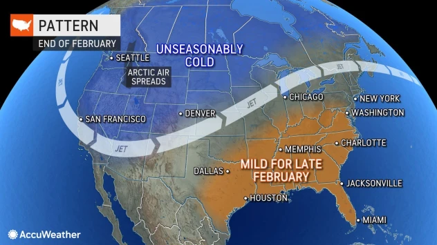
And finally –and as my headline eludes to– the North American continent could be about to be hit AGAIN, later in the month (a lot can change by then (hr 294), but this is certainly worth keeping a real close eye on):


GFS 2m Temperature Anomalies (C) Feb 18 [tropicaltidbits.com].

GFS Total Snowfall (inches) Feb 7 to Feb 23 [tropicaltidbits.com].


Europe’s Snow Blocks Roads, Traps Trains, And Kills At Least 10 In The Austrian/Swiss Alps Alone

Europe is currently in the grips of a plunging Arctic air mass, which, despite MSM pronouncements of a ‘climate emergency-induced snowless winter’ is delivering feet of the stuff to tens-of-millions of Europeans, from Norway to Greece…


Greece

Winter storm ‘Barbara’ –they gave it a name– is pounding Greece. Heavy snow has bee noted far south as Central Evia, with chains on vehicles now a requirement in Attica as well as sections of the Peloponnese.
A ban on large trucks is in place, too, with traffic also restricted in a number of Athens suburbs:


In the Fthiotida region (Central Greece), heavy machinery is dealing with icy conditions on roads from Lamia to Domokos, and from to Amfissa to Karpenissi. “It was an intense night due to icy conditions, but weather phenomena are becoming more intense as of early this morning, ” the Deputy Regional Director said Sunday.
In Magnissia prefecture, 72 plows were running throughout the night in intensifying snowfall — travel here was also banned.
While in nearby Turkey, some 4,000 people are now confirmed to have died in Monday’s historic M7.8 earthquake, with freezing wintry conditions now compounding the misery and hampering ongoing rescue efforts.
Temperature anomalies of -16C below the seasonal average are sweeping Turkey, with no let-up in sight.


GFS 2m Temperature Anomalies (C) for Feb 8 [tropicaltidbits.com].


Austria

At the Tyrol ski resort, Austrian authorities have logged at least 17 avalanches over the past 24 hours alone, with the wider Tyrol regions posting 30 on Saturday alone.
Between the Austria and Swiss Alps, at least 10 people are now confirmed to have died over the weekend following intense, record-challening snowfall. Tourists from New Zealand, China and Germany were among the dead.
Authorities have put in place a level four alert, meaning “very large avalanches are likely” — it advises inexperienced skiers to remain on open ski runs and trails and for experienced skiers to stay away from the slopes.
Elsewhere in Austria, heavy snow cut off 70 people from the outside world late last week. According to reports, 3 feet of fresh snow accumulated within 24 hours on Friday, trapping 70 people in the Wildalpen region due to blocked roads.


Trains Trapped In Poland

Trains have stopped running in parts of Poland, including on the Nowy Targ – Zakopane section.
Pictured below is a passenger train that became trapped in drifting snow in Biały Dunajec.
Passengers were evacuated by firefighters.


As with the continent’s cold, Europe’s snow also shows no signs of abating:


GFS Total Snowfall (inches) Feb 7 to Feb 23 [tropicaltidbits.com].

Related

Cold Wave Grips East Asia, Felling All-Time Snowfall Records Across Japan; Historic Snow In Moscow; + Christmas Freeze: Extreme Cold/Snow To Blast North America Over The HolidaysDecember 19, 2022In "Extreme Weather"
Hijiori, Japan Loses Power After 2.3m (7.6ft) Of Snow Hits; Severe Weather Warnings Encompass All Of Iceland; + N. Hemisphere Snow Extent Continues To Climb Far-Above Average, With Much More ForecastDecember 22, 2022In "Extreme Weather"
“Blockbuster” Cold Strikes North America; UK On For Its 9th Coldest December In 363-Years Of Record-Keeping; + Japan’s Unprecedented Snow Continues, Strands DriversDecember 20, 2022In "Extreme Weather"
 

alpha

Veteran Member
Electroverse

GMS-swing.jpg
Articles


Grand Solar Minimum And The Swings Between Extremes​


February 8, 2023 Cap Allon


[Article orginaly posted July, 2020 on the now censored and ‘vanished’ electroverse.net]

Research shows “blocking” persistence increases when solar activity is low, causing weather patterns to become locked in place at high and intermediate latitudes for prolonged periods of time.
During a Solar Minimum, the jet stream’s usual Zonal Flow (a west–east direction) reverts to more of a Meridional Flow (a north-south direction).
This is exaggerated further during a Grand Solar Minimum (GSM) –such as the one we’re likely entering now– and explains why regions become unseasonably hot or cold and others unusually dry or rainy with the extremes often then flipping a dime.


Zonal flow (left) vs Meridional flow (right) — see link below for more:
Explained: Low Solar Activity And A ‘Meridional’ Jet Stream Flow


Reject the politicized cries of “climate emergency!”, they are not rooted in science.


Electroverse


Mikhaël Schwander, et al, 2017 — “The zonal flow characteristic of westerly types is reduced under low solar activity as the continental flow for easterly and northerly types is enhanced. This is also confirmed by the higher blocking frequency over Scandinavia under low solar activity.”
Schwander’s paper, “Influence of solar variability on the occurrence of central European weather types from 1763 to 2009”, goes further:
“The 247-year-long analysis of the 11-year solar cycle impact on late winter European weather patterns suggests a reduction in the occurrence of westerly flow types linked to a reduced mean zonal flow under low solar activity. Based on this observational evidence, we estimate the probability to have cold conditions in winter over Europe to be higher under low solar activity than under high activity.”
The Sun appears to be slipping into its next Grand Solar Minimum cycle–a multidecadal spell of reduced solar output where the solar disc can be devoid of sunspots for months or even years at a time.
The impact on Earth’s climate will be one of violent swings between extremes: Intense bursts of heat will linger in one area, while a teeth-chattering chill will dominate nearby — and then the regions will “switch”. It’s this unpredictable chopping and changing that will hasten the failure of our modern food production systems; crops will fail, on a large scale, and famine will quickly ensue.
Overall, Earth’s temperature trends colder during a GSM as the Sun’s output sinks lower and lower (increasing cloud nucleation, being one factor); however, not ALL regions experience the chill. As with the previous GSM (the Maunder Minimum 1645-1715), areas such as the Arctic, Alaska, and southern Greenland/the North Atlantic actually warm during bouts of otherwise “global” cooling.
NASA reveals the phenomenon in their Maunder Minimum temperature reconstruction map:


Temp change between 1780 (a year of normal solar activity) and 1680 (a year within the depths of the Maunder Minimum) — NASA.

Earth’s climate is cyclic, never linear — and history repeats.
Once again, the Arctic appears to be warming, but in line with the historically low solar activity we’re experiencing and its effect on the jet stream, not due to human prosperity (i.e. Man’s CO2 excretions).

Global Temperatures Fall Below 30-Year Baseline, Now Down 0.75C From 2016 Peak


…it’s getting harder and harder for the establishment’s anti-human narrative to be maintained.


Electroverse

Related

Prof. Nils-Axel Mörner: “The Approaching Grand Solar Minimum and Little Ice Age Conditions”August 28, 2022In "Articles"
Grand Solar Minimum: The Future Looks ColdDecember 30, 2022In "Articles"
[A few of the] Scientists who warn of a coming Grand Solar Minimum and Little Ice AgeAugust 6, 2022In "Articles"
 

alpha

Veteran Member
Electroverse

snow-slovakia-e1675938580539.jpg
Articles Extreme Weather


Heavy Snow From Slovakia To Greece, Pakistan’s Historically Cold January; + Solar Activity Ultimately Controls The Climate​


February 9, 2023 Cap Allon


Heavy Snow From Slovakia To Greece

Strong winds and powerful snowstorms have caused traffic disruptions in Slovakia this week, as below average temperatures grip much of Europe.
Road, rail and air have been impacted across the country due to feet of accumulating snow, with Slovakia’s main east-to-west highway also closed.

https://twitter.com/ThisIsSlovakia_...ce-pakistans-cold-jan-solar-activity-climate/
This Is Slovakia

@ThisIsSlovakia_
·
Follow
Oh No! #ThisIsSlovakia #snow #snowstorm #snowfall #toomuchsnow Photo: Vladimír Šterbák


Image

3:14 AM · Feb 7, 2023
https://twitter.com/ThisIsSlovakia_...ce-pakistans-cold-jan-solar-activity-climate/
This Is Slovakia

@ThisIsSlovakia_
·
Follow
The village of Ždiar #ThisIsSlovakia #WinterWonderland #Winterwatch #snowfall #snowday #winter #snow Photo: M.Monka


Image

10:22 AM · Feb 6, 2023


Even as far south as Greece, flakes are settling, with a historic meter+ (3.3+ ft) coating parts of Evia island.
Winter storm ‘Barbara’ delivered anomalous lows and heavy snow for a fourth day in a row on Wednesday, with residents of Viotia, Fthiotida, Magnesia and Evia –for example– urged via text message to “drastically limit movements and follow the instructions of the authorities” due to the polar-like conditions.
Parts of the city of Volos are covered in almost a foot of snow, with similar totals also hitting Pilio and Zagora.
Heavier falls have been noted in Hania, Crete, and Evia island where over meter (3.3 ft) has been logged.
Power outages have been a common feature.


An emergency weather bulletin was issued the Greece’s National Meteorological Service warning that heavy snowfall across the majority of Greece and its islands will continue for the remainder of the week.
Many areas can also expect frosts with the iciest temperatures expected across the northwest.


Pakistan’s Cold January

Asia has suffered a historically frigid past few months, from NE Russia to Iran, from Kazakhstan to Japan.
The January numbers for Pakistan are in, and reveal that the South Asian nation suffered an average monthly temperature of 9.98C (50F), which is more that -2C below the 1991-2020 average and, even more impressively, is 1.25C below the 1961-1990 norm (a historically-cold era).
A myriad of all-time low temperature records were felled during the month, according to the Pakistan Meteorological Department, including Chitral’s 0.6C (33.1F)–which broke the previous record from 1977; Drosh’s 1C (33.8F); Saidu Sharif’s -4C (24.8F); and Nokkundi’s -10C (14F)–which busted the locale’s previous benchmark from 1934.
Pakistan, the fifth-most populous country on the planet, is in the midst of an economic collapse — one compounded by the historic and persistent freeze which has brought the nation’s energy infrastructure to its knees, leading to widespread blackouts which, in turn, have brought about the untimely deaths of hundreds-upon-hundreds, potentially thousands, of Pakistanis.
In January 2023, retail inflation soared to a 48-year-high of 27.6%, urban food inflation was at 39%, with rural food inflation soaring to 45.2%. Both urban and rural food inflation have remained in double digits for over 10 months now.
Pakistan’s economy is on the brink of collapse, and the country has been forced to go cap-in-hand to the International Monetary Fund for a bailout. One can only imagine what austere demands the IMF will put on the nation in order to avoid default.


Solar Activity Ultimately Controls The Climate

The global temperature record since 1880 is highly correlated to solar activity, and solar activity is highly correlated to the harmonics of planetary motion.
The below chart is NASA’s Historical Total Solar Irradiance Reconstruction, Time Series:


Historical Total Solar Irradiance Reconstruction, Time Series
(1610-2018) [climate.nasa.gov].
Also note that ‘flat-lining’ between (1645-1700): the Maunder Minimum.

What it reveals is that the AGW Party picked the ‘prefect’ starting point for their global warming hypothesis.
The faint vertical gray line indicates the year 1880, the supposed beginning of the industrial revolution–‘supposed’ because the revolution actually occurred between 1760 and 1840.
The year 1880, it just so happens, received the lowest solar output since the Dalton Minimum (1790-1830); it’s been up and up ever-since: Total Solar Irradiance (TSI) has been on a steady mark upward since exactly 1880.
In fact, the following 120+ years (1880 to approx. 2007) became so active and so sunspot-productive that the period was designated as a Grand Solar MAXIMUM–the strongest maxima of the past 4,000 years, no less–and it should come as no surprise then that global temperatures increased.
In recent years, however –namely since the onset of Solar Cycle 24 (2008)– activity on the Sun has been decreasing, sharply. And while there is a complex and poorly understood lag between changes in solar activity and the global temperature record (ocean thermal inertia likely being one culprit), Earth’s mercury is now falling, down approx. 0.75C since the 2016 peak.
As eminent Russian space scientist Habibullo Abdussamatov has stated: “Nothing will avert the onset of the next deep temperature drop, the 19th in the last 7500 years, which without fail follows after natural warming.”

Arctic Obfuscations

The AGW Party’s cherry-picked starting point of 1880 recalls the similarly-obfuscating ‘Arctic sea ice’ debacle.
Those charged with peddling the global warming narrative (NOAA, NASA, the IPCC–and their MSM lapdogs) chose the year 1979 to begin their referencing, which, akin to the gamesmanship on show above, was a very deliberate and ideally-timed ‘pick’.
Unknown to most, we actually posses reliable polar ice data extending back to the 1920s (much further if you include ice cores, of course). What these historical data reveal is that our planet’s climate is cyclic; but more to the point, they show that northern hemisphere sea ice extent was at an historically high level in 1979, yet just five years prior had been at historically low levels:


The ebbing-and-flowing and melting-and-refreezing of the Arctic is clearer-still in the ‘Vinnikov’ chart below.
Again note the historically high point of ‘sea ice amount’ NOAA begin their modern-day charts with.


This establishment obfuscation smacks you in the face. Hard.
But ‘obfuscation’ is me being generous, for this has all the hallmarks of outright ‘fraud’ — as demonstrated by NOAA attempting to replace these historic charts, which show clear ice gains throughout the 1970s, with their own manipulated charts, which now depict an unexplained decrease in Arctic sea ice during the decade:


This ‘manipulation’ and many more like it are being used to force-through a poverty-inducing reshaping of our world, one driven by the whim of a handful of powerful elites who seek control and power at the detriment of 8-billion innocent souls.
Human prosperity (i.e. cheap and reliable energy) is bad, they tell us; as is the production of healthy, organic food.
Resist this poisonous propaganda, for it will be the end of us; instead, be driven by logic, commonsense and compassion.

Related

North America Could Be Hit AGAIN; + Europe’s Snow Blocks Roads, Traps Trains, And Kills At Least 10 In The Austrian/Swiss Alps AloneFebruary 7, 2023In "Articles"
Chile’s Chilly August; Greece Logs Coldest Sept Temp Ever (Lows Also Fall In Crete); Record Cold To Blast Australia–As ABC Attempts To Dismiss The Continent’s “Bumper Snow Season”September 28, 2022In "Extreme Weather"
Northern Hemisphere Snow Season Off To A Near-Record Start; Cold September Across Scandinavia; October Snow Hits NZ; Antarctic Air Approaches Australia; Record Cold NYC; + 30% Chance Of An X-FlareOctober 5, 2022In "Extreme Weather"
 

alpha

Veteran Member
Electroverse

u10serie_cfsRawCorrGefs-e1676023119306.png

Articles
Extreme Weather


Heavy Snow Strikes Lebanon; The Balkans Freeze; Collapse Of The Polar Vortex Looms (SSW); + Top Russian Space Scientist: “We Should Fear A Deep Temperature Drop, Not Global Warming”​


February 10, 2023 Cap Allon


Heavy Snow Strikes Lebanon

Western Asia continues to get pounded with anomalous lows and disruptive snows.
Today’s Lebanon, particularly the norther districts of Bsharri and Keserwan.
The snow depth in Hadchit is measuring at 1.2m (almost 4 feet), with far larger accumulations posted at higher elevations.


Thierry Goose

@ThierryGooseBC


Heavy #snow in northern #Lebanon , especially in the Bsharri and Keserwan Districts [Cazas] above 1,000 m. Snow depth of up to 120 cm were observed in Hadchit (1,400 m) and much more at higher elevations. The photos are from the Lebanon Weather Forecast Facebook page.


Kfardebian (≈1,600 m)


Kfardebian (≈1,600 m)


Bsharre El Arez (1,550 m)


Arbet Kozhaya (1,000 m)


Extreme Temperatures Around The World and 5 others

9:29 PM · Feb 9, 2023·
4,488
Views


Mount Hermon, the summit of which straddles the Syria/Lebanon border is seeing Arctic-like conditions:


The Balkans Freeze

The cold is infecting regions to the west, too, including the Balkans area of southeastern Europe.
Turkey is suffering freezing lows and blizzard conditions to close the week which is compounding the tragedy resulting from Monday’s historic earthquake. Those impacted are having to choose between staying inside–with the risk of building collapse, or venturing outside–with the risk of hypothermia.
The cold is extending into the likes of Bosnia, Montenegro and Serbia, too, with bone-chilling lows posted there this morning.
A remarkable -31.1C (-24F) was posted in Romanina, in Întorsura Buzăului.
Milos Milic
Feb 9, 2023
@skomimaster
·
Follow
The coldest morning so far on this winter at this part of Balkans -26°C Kosanica (Montenegro) -23°C Sjenica (Serbia) -21°C Karajukića Bunari (Serbia) -20°C Sokolac (Bosnia) -19°C Žabljak (Montenegro)


Image: https://www.wetteronline.de/temperatur?wrm=6&wrx=44.04,20.21


Thierry Goose

@ThierryGooseBC
·
Follow
A remarkable -31.1°C in Întorsura Buzăului (707 m), #Romania.


Image

11:31 PM · Feb 9, 2023
A station at Bükk Mountains, Hungary dropped to a staggering -23.9C (-11F) this morning.


Cold Jans For New Caledonia, Martinique And Reunion

Very briefly:
January 2023 in New Caledonia, Martiniqe and Reunion finished with average temperatures below the multidecadal average.


Collapse Of The Polar Vortex Looms (SSW)

Next week, the Stratosphere is expected to serve up a full-blown Sudden Stratospheric Warming event (SSW).
Multiple forecasts are calling for a reversing of the stratospheric circulation from westerly to easterly, playing out during the second-half of February (note the green line below):


Moreover, this SSW looks strong and threatens to be a record-challenging event.
As well as the GEFS ensembles, as embedded above, the ECMWF is also picking up on it.
The ECMWF shows the zonal wind reversing into negative territory and then holding there for an extended period:

polar-vortex-wind-speed-ecmwf-extended-ensemble-forecast-sudden-stratospheric-warming-2022-2023-event

This event is also visible in the monstrous warming wave currently forecast for the mid-stratosphere (see below).
This wave is predicted to engulf the polar regions, combine with a strong emerging polar “anti-vortex” over the North Pacific/western Arctic, and then ‘spit’ the Polar Vortex out and to the south:

stratospheric-polar-vortex-north-hemisphere-forecast-mid-february-winter-temperature-pressure-pattern-sudden-stratospheric-warming

Next, the pressure anomalies map highlights this powerful high-pressure system, or “anti-vortex”.
Such strong pressure anomalies will often displace the main Polar Vortex and reverse the circulation.

polar-vortex-north-hemisphere-forecast-mid-february-pressure-anomaly-pattern-weather-10mb-pattern-sudden-stratospheric-warming

Tellingly, this warming is also present in the lower Stratosphere (that is, approx. 19km or 12miles).
The lower the warming permeates, the more robust it the event is.
Reaching these levels adds support to this being a very strong event.

polar-vortex-north-hemisphere-forecast-mid-february-temperature-pressure-pattern-weather-50mb-sudden-stratospheric-warming

North America is forecast another Arctic blast next week, but this is not tied to the aforementioned SSW event.
SSWs can take a week or two to impact our lower troposphere/latitude weather as their ‘effects’ have to ‘filter down’ from the Stratosphere. North America’s looming cold shot is merely your standard buckling of the jet stream (a phenomenon predicted to increase during times of low solar activity, such as the historically low output we’re experiencing now).
I will be sure keep track of atmospheric developments over the weekend –i.e. the temperature, pressure, and wind anomalies in the Stratosphere– and will report back Monday. If this to be a true collapse, anomalies should start shifting ‘downwards’, slowly, filtering into the lower atmospheric levels as February progresses.
It’s still early days, but conditions are currently ripe for an SSW event making a run for the lower troposphere (where our weather happens). Both the ECMWF and GEFS extended ensemble solutions show an SSW development. So all eyes on the skies.


Top Russian Space Scientist: “We Should Fear A Deep Temperature Drop, Not Global Warming”

The Sun defines the climate, not carbon dioxide,” so says eminent Russian space scientist, Habibullo Abdussamatov (Dr. Sc. – Head of Space research laboratory of the Pulkovo Observatory).
Observations of the Sun show that carbon dioxide is “not guilty” for the steady increase in temperature observed over the past few decades, and that what lies ahead in the coming years is not catastrophic warming but a global and very prolonged temperature drop.
The slight warming we just experienced had a natural origin, the contribution of CO2 was insignificant — carbon dioxide does not serve as an explanation, the Sun does.
The so-called ‘greenhouse effect’ will not avert the onset of the next deep temperature drop, the 19th in the last 7500 years, which without fail follows after natural warming.
“We should fear a deep temperature drop — not catastrophic global warming,” warns Abdussamatov, who was one of the researchers featured in the 2009 U.S. Senate Report of More Than 700 Dissenting Scientists Over Man-Made Global Warming.
“Humanity must survive the serious economic, social, demographic and political consequences of a global temperature drop, which will directly affect the national interests of almost all countries and more than 80% of the population of the Earth.”
The global average temperature has already dropped 0.75C since the 2016 peak (UAH), and a further 1.25C-or-so drop will see us down to Maunder Minimum levels (a.k.a. the Little Ice Age) and we all know how well that went for humanity…
Earth’s climate is cyclic, never linear — driven mainly by the Sun.
The Sun is once again shutting down, relatively — prepare.

Related

California’s Quiet Wildfire Season; Snowfall Records Fall Across US; Monthly Low Temp Benchmarks Tumble Down Under As Rare Spring Flakes Hit Tasmania; Villages Cut Off As Heavy Snow Hits Kashmir; + Europe’s Food Prices SoarNovember 16, 2022In "Articles"
U.S. Suffers Its Coldest-Ever Wind Chill Reading; Australia’s Summer Snow Extends To New Zealand, Leaving Behind Record Cold; + More Than 650 Dead As M7.8 Earthquake Strikes Syria And TurkeyFebruary 6, 2023In "Articles"
“Blockbuster” Cold Strikes North America; UK On For Its 9th Coldest December In 363-Years Of Record-Keeping; + Japan’s Unprecedented Snow Continues, Strands DriversDecember 20, 2022In "Extreme Weather"
 

jed turtle

a brother in the Lord
Electroverse

u10serie_cfsRawCorrGefs-e1676023119306.png

Articles Extreme Weather


Heavy Snow Strikes Lebanon; The Balkans Freeze; Collapse Of The Polar Vortex Looms (SSW); + Top Russian Space Scientist: “We Should Fear A Deep Temperature Drop, Not Global Warming”​


February 10, 2023 Cap Allon


Heavy Snow Strikes Lebanon

Western Asia continues to get pounded with anomalous lows and disruptive snows.
Today’s Lebanon, particularly the norther districts of Bsharri and Keserwan.
The snow depth in Hadchit is measuring at 1.2m (almost 4 feet), with far larger accumulations posted at higher elevations.


Thierry Goose
@ThierryGooseBC


Heavy #snow in northern #Lebanon , especially in the Bsharri and Keserwan Districts [Cazas] above 1,000 m. Snow depth of up to 120 cm were observed in Hadchit (1,400 m) and much more at higher elevations. The photos are from the Lebanon Weather Forecast Facebook page.

Kfardebian (≈1,600 m)

Kfardebian (≈1,600 m)

Bsharre El Arez (1,550 m)

Arbet Kozhaya (1,000 m)

Extreme Temperatures Around The World and 5 others

9:29 PM · Feb 9, 2023·
4,488
Views


Mount Hermon, the summit of which straddles the Syria/Lebanon border is seeing Arctic-like conditions:

The Balkans Freeze

The cold is infecting regions to the west, too, including the Balkans area of southeastern Europe.
Turkey is suffering freezing lows and blizzard conditions to close the week which is compounding the tragedy resulting from Monday’s historic earthquake. Those impacted are having to choose between staying inside–with the risk of building collapse, or venturing outside–with the risk of hypothermia.
The cold is extending into the likes of Bosnia, Montenegro and Serbia, too, with bone-chilling lows posted there this morning.
A remarkable -31.1C (-24F) was posted in Romanina, in Întorsura Buzăului.
Milos Milic
Feb 9, 2023
@skomimaster
·
Follow
The coldest morning so far on this winter at this part of Balkans -26°C Kosanica (Montenegro) -23°C Sjenica (Serbia) -21°C Karajukića Bunari (Serbia) -20°C Sokolac (Bosnia) -19°C Žabljak (Montenegro)
Image: https://www.wetteronline.de/temperatur?wrm=6&wrx=44.04,20.21


Thierry Goose
@ThierryGooseBC
·
Follow
A remarkable -31.1°C in Întorsura Buzăului (707 m), #Romania.
Image
11:31 PM · Feb 9, 2023
A station at Bükk Mountains, Hungary dropped to a staggering -23.9C (-11F) this morning.

Cold Jans For New Caledonia, Martinique And Reunion

Very briefly:
January 2023 in New Caledonia, Martiniqe and Reunion finished with average temperatures below the multidecadal average.

Collapse Of The Polar Vortex Looms (SSW)

Next week, the Stratosphere is expected to serve up a full-blown Sudden Stratospheric Warming event (SSW).
Multiple forecasts are calling for a reversing of the stratospheric circulation from westerly to easterly, playing out during the second-half of February (note the green line below):


Moreover, this SSW looks strong and threatens to be a record-challenging event.
As well as the GEFS ensembles, as embedded above, the ECMWF is also picking up on it.
The ECMWF shows the zonal wind reversing into negative territory and then holding there for an extended period:

polar-vortex-wind-speed-ecmwf-extended-ensemble-forecast-sudden-stratospheric-warming-2022-2023-event

This event is also visible in the monstrous warming wave currently forecast for the mid-stratosphere (see below).
This wave is predicted to engulf the polar regions, combine with a strong emerging polar “anti-vortex” over the North Pacific/western Arctic, and then ‘spit’ the Polar Vortex out and to the south:

stratospheric-polar-vortex-north-hemisphere-forecast-mid-february-winter-temperature-pressure-pattern-sudden-stratospheric-warming

Next, the pressure anomalies map highlights this powerful high-pressure system, or “anti-vortex”.
Such strong pressure anomalies will often displace the main Polar Vortex and reverse the circulation.

polar-vortex-north-hemisphere-forecast-mid-february-pressure-anomaly-pattern-weather-10mb-pattern-sudden-stratospheric-warming

Tellingly, this warming is also present in the lower Stratosphere (that is, approx. 19km or 12miles).
The lower the warming permeates, the more robust it the event is.
Reaching these levels adds support to this being a very strong event.

polar-vortex-north-hemisphere-forecast-mid-february-temperature-pressure-pattern-weather-50mb-sudden-stratospheric-warming

North America is forecast another Arctic blast next week, but this is not tied to the aforementioned SSW event.
SSWs can take a week or two to impact our lower troposphere/latitude weather as their ‘effects’ have to ‘filter down’ from the Stratosphere. North America’s looming cold shot is merely your standard buckling of the jet stream (a phenomenon predicted to increase during times of low solar activity, such as the historically low output we’re experiencing now).
I will be sure keep track of atmospheric developments over the weekend –i.e. the temperature, pressure, and wind anomalies in the Stratosphere– and will report back Monday. If this to be a true collapse, anomalies should start shifting ‘downwards’, slowly, filtering into the lower atmospheric levels as February progresses.
It’s still early days, but conditions are currently ripe for an SSW event making a run for the lower troposphere (where our weather happens). Both the ECMWF and GEFS extended ensemble solutions show an SSW development. So all eyes on the skies.

Top Russian Space Scientist: “We Should Fear A Deep Temperature Drop, Not Global Warming”

The Sun defines the climate, not carbon dioxide,” so says eminent Russian space scientist, Habibullo Abdussamatov (Dr. Sc. – Head of Space research laboratory of the Pulkovo Observatory).
Observations of the Sun show that carbon dioxide is “not guilty” for the steady increase in temperature observed over the past few decades, and that what lies ahead in the coming years is not catastrophic warming but a global and very prolonged temperature drop.
The slight warming we just experienced had a natural origin, the contribution of CO2 was insignificant — carbon dioxide does not serve as an explanation, the Sun does.
The so-called ‘greenhouse effect’ will not avert the onset of the next deep temperature drop, the 19th in the last 7500 years, which without fail follows after natural warming.
“We should fear a deep temperature drop — not catastrophic global warming,” warns Abdussamatov, who was one of the researchers featured in the 2009 U.S. Senate Report of More Than 700 Dissenting Scientists Over Man-Made Global Warming.
“Humanity must survive the serious economic, social, demographic and political consequences of a global temperature drop, which will directly affect the national interests of almost all countries and more than 80% of the population of the Earth.”
The global average temperature has already dropped 0.75C since the 2016 peak (UAH), and a further 1.25C-or-so drop will see us down to Maunder Minimum levels (a.k.a. the Little Ice Age) and we all know how well that went for humanity…
Earth’s climate is cyclic, never linear — driven mainly by the Sun.
The Sun is once again shutting down, relatively — prepare.

Related

California’s Quiet Wildfire Season; Snowfall Records Fall Across US; Monthly Low Temp Benchmarks Tumble Down Under As Rare Spring Flakes Hit Tasmania; Villages Cut Off As Heavy Snow Hits Kashmir; + Europe’s Food Prices SoarNovember 16, 2022In "Articles"
U.S. Suffers Its Coldest-Ever Wind Chill Reading; Australia’s Summer Snow Extends To New Zealand, Leaving Behind Record Cold; + More Than 650 Dead As M7.8 Earthquake Strikes Syria And TurkeyFebruary 6, 2023In "Articles"
“Blockbuster” Cold Strikes North America; UK On For Its 9th Coldest December In 363-Years Of Record-Keeping; + Japan’s Unprecedented Snow Continues, Strands DriversDecember 20, 2022In "Extreme Weather"
Ok, another deep freeze is on the way in the next week or so I gather. It was -44 F wind chill around here last week. Nothing to get caught out in for very long. And then a strong warming event no doubt with very strong wind along for the ride sometime after that. i am guessing that that map above indicates that the deep cold is being pushed over to the East Europe area that will aide freezing the mud terrain in the Ukraine, so that the next offensive can get underway. Lots of death occurring around the world just now: quake in Turkey/ Syria, Russia/ Ukraine war, up to 80% of the world vaxxed (The walking dead?) for the allegedly the COVID virus / or synthetic snake venom per Dr. Brian Ardis, and anyways the vax appears far worse than the COVID whatever. Let’s not fail to mention the deaths hovering just over the time horizon if NATO AND RUSSIA goes hot. At that point we all get to see what true “global warming“ looks like, followed rather quickly by nuclear winter... Enough of my happy talk. Think I will bring another armload of firewood in...
 

alpha

Veteran Member
Electroverse

sun-earth-e1676283129722.png
Articles Extreme Weather


Cold Spain, Cyprus And Eastern Europe; SSW Update; + Scientists Use Artificial Intelligence To Forecast Sunspot Cycles​


February 13, 2023 Cap Allon


Cold Spain, Cyprus And Eastern Europe

Despite the calls for a ‘no show winter’, swathes of Europe have held anomalously-cold since the turn of the year.
January 2023 in Spain, for example, had an average temperature of 5.9C (42.6F), which is below the multidecadal average.
Temperature anomalies map comes courtesy of Aemet.


The cold has also swept the likes of Cyprus, Greece and Italy, where it is still being felt into February.
Chromio, Cyprus –near Mount Olympus– recently plunged to -12C (10.4F) which is just 0.6C off of breaking the national record, according to the Cyprus Department of Meteorology. A chilly -11C was logged at Troodos Mountain — a new all-time low for the locale.
It has been bitingly cold across Eastern Europe in recent weeks, culminating in the recent -31.9C (-25.4F) posted in Turkey, the -31.1C (-24F) in Romania, -30C (-22F) in Montenegro, -24C (-11.2F) in Serbia.
Looking ahead, much of Europe is forecast a reprieve from the freeze this week, with concerns turning to that developing SSW…


SSW Update

The Sudden Stratospheric Warming (SSW) event first discussed Friday is progressing as forecast.
The event is set to deliver a full-blown reversal of the Zonal winds through the second half of February, with any impacts on our Lower Tropospheric weather due into March.


Below is an updated pressure and temperature forecast for the middle Stratosphere this week.
Clearly visible is that strong stratospheric warming wave advancing across the Polar regions, which is weakening the Polar Vortex via a reversing of the circulation and effectively forcing it out of the North Pole.
In other words, the stratospheric Polar Vortex is breaking down.

polar-vortex-weather-forecast-snowfall-cold-warm-united-states-canada-stratospheric-warming-disruption-event-usa


Such a Stratospheric event will impact lower atmospheric levels — the question is to what extent.
Based on first indications this is setting up to be a full-blown breakdown of the stratospheric circulation meaning we should expect a strong impact on the lower troposhere (where our weather happens), likely by early-March.
Arctic outbreaks and the anomalous cold and increased snowfalls they deliver are typical of such events, with history informing us that the worst hit regions are typically the eastern United States, northern Russia and Europe.
Much is left to be determined, however, so stay tuned for updates.

Heavy Snow Strikes Lebanon; The Balkans Freeze; Collapse Of The Polar Vortex Looms (SSW); + Top Russian Space Scientist: “We Should Fear A Deep Temperature Drop, Not Global Warming”


Earth’s climate is cyclic, never linear — driven mainly by the Sun. The Sun is once again shutting down, relatively — prepare.
Scientists Use Artificial Intelligence To Forecast Sunspot Cycles
[Below is an abridged version of an article originally posted on the now censored/’vanished’ electroverse.net]

Scientists have used artificial intelligence to predict sunspots looking forward AND also correct the incomplete record of the past.
A paper published in Advances in Space Research by Dr Victor Velasco Herrera, a theoretical physicist at the National Autonomous University of Mexico; Dr Willie Soon, an award-winning solar astrophysicist at the Harvard-Smithsonian Center for Astrophysics; and Professor David Legates, a climatologist at the University of Delaware and former director of the U.S. Global Change Research Program, predicts that the new 11-year solar cycle that has recently begun will show near-record low sunspot activity that will last until mid-century.


Sunspots Matter

When there are many sunspots, i.e. when the Sun is active, there is a danger that a strong solar ejection directed towards the Earth could damage or even destroy the thousands of satellites on which the world depends for everything — from radio, telephone, television and internet communications to monitoring the climate and observing the farthest reaches of the universe.
Worse, a very strong solar storm could damage the largely unshielded terrestrial electricity grid. Most power lines and transformers are above ground and thus acutely vulnerable. Solar panels, too, could have their lives shortened by intense solar radiation.
The three scientists taught a machine-learning algorithm how to recognize underlying patterns and cycles in the past 320 years’ sunspot record.
The algorithm then discovered a hitherto-unnoticed interaction between the 5.5-year solar half-cycles (blue) and the 120-year Gleissberg double cycles (red dotted lines–as shown in the figure below) which allowed it to confirm the earlier predictions of a quiet half-century to come — predictions which are now shared by solar physicists.
That interaction between the two periodicities led the algorithm to indicate that from the 1730s to the 1760s, early in the modern sunspot record (the gray band), sunspots appear to have been under-recorded: as the 120-year cycle approached its maximum amplitude, sunspots should have been more numerous than reported at the time.


Periods of minimum and maximum solar activity from 1700 to 2020 analyzed by machine learning.

The algorithm then predicted the sunspots from 2021 to 2100.
It suggests that the current low solar activity is likely to continue until 2050:


The Sun may be quiet for half a century.

Dr Soon said: “The machine-learning algorithm, with its interesting interplay between the very short 5.5-year cycle and the long 120-year cycle, confirms our results of 10-15 years ago suggesting that the next three or four solar cycles will be comparatively inactive. This is the first time that the twin problems of hindcasting incomplete past records and forecasting the future have been combined in a single analysis.”
Dr Legates said: “Given the history of previous periods of comparative solar activity, the weather may get a little cooler between now and 2050. If we are right, our electricity grids and our satellites should be safe until then.”

You can download the new paper HERE.


The Sun painted by a machine-learning algorithm in the style of Van Gogh’s Starry Night

I, personally, feel that what we’re currently seeing with solar cycle (25)–i.e. daily sunspot numbers firing around the 200 mark–is ‘death throes’, with the cycle spitting out a final burst of energy before an earlier-than-forecast peak followed by a steady and uneventful demise — a fizzling out.
It has long-been my contention that cycle 26 is where the real ‘fun’ begins, where a stark drop in activity correlates with a sharp drop in global temperatures… but we may not need to wait that long.
If SC25 ends comparable to SC24–the weakest cycle in more than a century–as is looking likely, then we will already be well on our way to posting an extended Minimum period, one comparable to the Dalton Minimum where global temps plunged -2C in less than 20 years, with a deeper, full-blown GRAND Solar Minimum still potentially in the offing.
Time will tell, of course. But note that global temperatures are already (as of Jan 2023) down 0.75C from their 2016 peak, and another 1.25C decrease isn’t all that hard to imagine, particularly considering the cumulative effects of the historically low solar activity we’ve been experiencing since the early-2000s, which continue to mount.
And lastly, for those thinking that this recent uptick in output means Solar Cycle 25 is unusually-strong and is firing above its predecessor, think again: The latest ‘solar cycles comparison’ chart (Feb 13), courtesy of solen.info, paints a clear picture…


Solar Cycle 25 progression (green line) compared to 24, 23, 22 & 21 [updated Feb 13, 2023 — solen.info]

Related

Asia’s Record-Breaking Arctic Outbreak Reaches Indian Ocean: Alerts Issued In India, China, Taiwan and Others; Big Freeze To Return To Europe (Just In Time For Davos); + U.S. To Be Pummeled Again Later In The MonthJanuary 13, 2023In "Extreme Weather"
Study: India’s ‘Cold Waves’ Have Increased Over The Past Decade; Summer Snow Clips Australia; + Arctic Outbreaks For Asia, Europe And North America–With All-Time Record Cold Forecast Across The NortheastFebruary 3, 2023In "Articles"
*Another* Historic Arctic Outbreak For Canada And The U.S.; Fierce Freeze Forecast For Europe, Including UK; + Two Russian Volcanoes StirNovember 24, 2022In "Extreme Weather"
 

alpha

Veteran Member
Electroverse

image-24.png
Articles Extreme Weather


Big Freeze Grips Much Of North America; Cold Manila; “We Have 500 Days To Avoid Climate Chaos”; + Escape And Farm​


February 14, 2023 Cap Allon


Big Freeze Grips Much Of North America

A pair of polar fronts barreling into the Western U.S. are ushering in record-challenging cold and low-level snowfall.
“A cold front located 250 miles northwest of San Francisco, the first in a series of two cold fronts, will arrive today,” Bay Area forecasters said Monday, with the second more powerful system arriving in quick succession, on Tuesday.
“Tuesday’s cold front will be accompanied by low freezing levels,” continued the forecasters, adding that San Francisco counties should “expect well-below February normal temperatures and near record lows during mid-week with Wednesday and Thursday the coldest.”
As a result, the NWS has issued freeze watches for Tuesday and Wednesday, with more likely Thursday.
The low temperatures could kill crops and other vegetation and damage unprotected outdoor plumbing. Residents are urged to start now to protect plants and outdoor water pipes. Pipes should be wrapped and drained or allowed to drip slowly.
This intensifying freeze isn’t confined to the West Coast — far from it.
Much of North America is on course to receive a true Arctic walloping:


GFS 2m Temperature Anomalies (C) Feb 14 – Feb 18 [].

And looking further ahead, that potential SSW event remains a concern for early-March:

Heavy Snow Strikes Lebanon; The Balkans Freeze; Collapse Of The Polar Vortex Looms (SSW); + Top Russian Space Scientist: “We Should Fear A Deep Temperature Drop, Not Global Warming”


Earth’s climate is cyclic, never linear — driven mainly by the Sun. The Sun is once again shutting down, relatively — prepare.


Electroverse


Cold Spain, Cyprus And Eastern Europe; SSW Update; + Scientists Use Artificial Intelligence To Forecast Sunspot Cycles


AI: “Low Solar Activity Until 2050”.


Electroverse


Cold Manila

Metro Manila’s air temperature dropped to an unusually-frigid 20.3C (68.5F) on Valentine’s Day, in Quezon City.
As per the Philippine Atmospheric, Geophysical and Astronomical Services Administration (PAGASA), Manila’s cold can be attributed to the prevailing northeast monsoon, or “amihan.”
PAGASA expects “cold surges” to persist until at least the end of the month, with surface air temperatures to hold cooler than average across most parts of the country.


“We Have 500 Days To Avoid Climate Chaos”

Fear is a powerful weapon. The threat of an impending “climate catastrophe” has been used to control the global population for decades. It’s time we all woke up.
In the 1960s and 1970s, warnings of Ozone Depletion, Killer Acid Rain, crop-ending droughts, and even an impending Ice Age permeated the newspapers of the day, threats intentionally crafted to keep the sheep scared and compliant.
Then, by the 1980s these warnings had been honed, meticulously and malevolently molded into perhaps the greatest controlling measure ever devised. At the close of the decade the elites were ready to unleash it on the masses.
They realized that blaming the people for any looming catastrophe provided additional exploitable layers to the fear. Layers of guilt, of infighting and division, and of taxation. The name of the controlling measure was Anthropogenic Global Warming (AGW).
NASA’s James Hansen’s Congressional testimony in 1988 set the ball rolling, or at least can be credited with bringing the “measure” to the attention of politicians. Hansen linked human CO2 emissions to rising global temperatures and projected three ‘warming scenarios’ moving into the future (click here for how well he did — spoiler: he did terribly).


Wasting no time in rolling out Project Fear, the UN and its corrupted MSM lapdogs ran with Hansen’s testimony and quickly began peddling-out their own scientifically-baseless doomsday scenarios.
An AP headline from as early as 1989 read: “Rising seas could obliterate nations: U.N. officials” — the article detailed a U.N. environmental official warning that entire nations would be wiped off the map if the world failed to reverse warming by 2000.
Science told us the Arctic would be completely free of summer ice by 2009, by 2013, by 2015, by 2016, by 2018, and now by… 2050…? with mainstream publications never questioning the mounting pile of FAILED prophesies.
Al Gore is king of the bullshitters, but the majority of modern politicians have bought into the ruse, too (they’ve had to in order to placate a small yet noisy –and brainwashed– section of the populous)–though some do push it further than others and as a result blindly subject their future selves to ridicule and forced retraction when their predictions are inevitably proven wrong.
Back in May, 2014, French foreign minister Laurent Fabius, during a joint appearance with then U.S. Secretary of State John Kerry, claimed “we have 500 days to avoid climate chaos.”
Fabius’s ludicrous comments were made during the early drafting of the Paris Climate Deal, a deal which gained 195 signatories and eventually became effective as of November 2016 (around 60 days after France’s foreign minister’s deadline for disaster).
But Fabius certainly isn’t alone.
Recent history is littered with examples of expired doomsday dates. There are long lists compiled on blogs across the web; there are catalogs documenting thousands upon thousands of failed climate predictions from politicians, scientists, and journalists alike. Unfortunately though, this reality is never touched by the bought-out and utterly corrupted MSM — The Science is settled, after-all, and the fact that every dire climate prediction of the past 40 years has been wrong is seemingly completely irrelevant.
We humans are sheep, though.
We are easily herded.
The few anti-authoritarians among us have an increasingly hard job because modern avenues for revolt are being shutdown. So-called “Fact-Checkers” are filtering speech across the internet, and they and they alone decide what’s true, and so, at the behest of their Totalitarian backers, they can shape the narrative and therefore reality itself–and on all topics, too: from AGW to COVID, from the Ukraine to BLM, from vinyl chloride spills to the destruction of our food supply.
It’s long time we stand up.
It’s time we revolt.


Escape And Farm

Personally, ‘escaping the system’ has been my insurrection, with myself and my young family now off-grid and growing our own food in Central Portugal.
The establishment does not have our best interests at heart –to put it mildly– and if you want energy and food security then you need to work for it — at least these are my convictions.
And with that in mind, I’m now going to shut the laptop and head out to continue construction of our new pig enclosure and sty. We have KuneKunes arriving next month, and these stocky escape artists need a robust pen to keep them in–with electric fencing, too.
Also this Spring, I’m planning to grow the ancient wheat variety ‘Emmer’ for its health benefits.
Emmer is closely related to Einkorn, the original or “mother” wheat, and both have far superior health properties compared to modern day wheat which has been hybridized for yield and gluten content over quality.
I will try a small patch of Einkorn, too, but I’ve read that Emmer rose to dominate Einkorn in ancient times because it was easier to grow, tolerated heat better (good for Portugal!), and was less likely to drop its seed before harvest.
If anyone has any experience growing either of these varieties, please feel free to offer me some much needed advice in the comments.
Energy and food security are not something owed, but earned.


Related

Cold Wave Grips East Asia, Felling All-Time Snowfall Records Across Japan; Historic Snow In Moscow; + Christmas Freeze: Extreme Cold/Snow To Blast North America Over The HolidaysDecember 19, 2022In "Extreme Weather"
Record Lows And Deadly Snows Sweep Japan; Iceland’s Coldest December For 50 Years; + Cold Arctic Skies Produce Rare ‘Polar Stratospheric Clouds’January 25, 2023In "Extreme Weather"
China Approaches -50C (-58F); Record Cold In The Dominican Republic; Summer Snow Down Under, Another 12 *Monthly* Low Temp Records Felled; + The Sun Is Crackling With M-FlaresDecember 15, 2022In "Extreme Weather"
 

alpha

Veteran Member
This puts us into 2025, which is when a lot of the talking bobble heads are saying the Sun's micro nova will be at it's apex.
The statement was made in 2014...
Back in May, 2014, French foreign minister Laurent Fabius, during a joint appearance with then U.S. Secretary of State John Kerry, claimed “we have 500 days to avoid climate chaos.”
Fabius’s ludicrous comments were made during the early drafting of the Paris Climate Deal, a deal which gained 195 signatories and eventually became effective as of November 2016 (around 60 days after France’s foreign minister’s deadline for disaster).
 

alpha

Veteran Member
Electroverse

snow-train-2-e1676451240618.jpg
Articles


Northern Hemisphere Snow Mass Tracks Above 1982-2012 Average, As It Has Done For The Past 7 Years​


February 15, 2023 Cap Allon


Data from the Finnish Meteorological Institute (FMI) reveal that Total Snow Mass for the Northern Hemisphere has comfortably held above 1982-2012 average ALL season and is now also punching above the standard deviation.
Feel free to shovel this fact down the throats of those mindless, unquestioning and narrative-trusting fools that still believe the world is burning up and that snowfall is a thing of the past:


[FMI]

I’ve also taken the time to trawl through the historical FMI charts.
What I’ve found is that this trend of growth appears to have commenced back in 2017.
Compiled below are the NH snow mass charts starting in 2016 for comparison (not all the dates match but I have managed to show the ‘peak’ for each year, which occurs usually early-March), which provide a clear picture:


2016:


2017:


2018:


2019:


2020:

fmi_swe_tracker-7.jpg


2021:

fmi_swe_tracker-8.jpg


2022:

fmi_swe_tracker-9.jpg


And I’ll finish where we started the article, with this year’s latest datapoint (Feb 12, 2023):

fmi_swe_tracker-2.jpg


Note that we are at the juncture–the time of year–when Northern Hemisphere snow mass usually ‘takes off’ and launches well-above that multidecadal average–at least this has been the case since 2017 (particularly in 2021).
Looking at this year’s chart, we appear to be on the cusp of another step up.
The latest GFS ‘total snowfall’ runs also give us reason to think this:


GFS Total Snowfall (inches) Feb 15 – March 3 [tropicaltidbits.com]

GFS Total Snowfall (cm) Feb 17 – March 3 [tropicaltidbits.com]

GFS Total Snowfall (cm) Feb 15 – March 3 [tropicaltidbits.com]

Clear for all to see–and for all climate alarmists to ignore–Northern Hemisphere snow mass is on the uptick, consistently running well-above the 1982-2012 average used by the FMI.
What more will it take for the veil of dumb acceptence to be lifted?

Global Temperatures Fall Below 30-Year Baseline, Now Down 0.75C From 2016 Peak


…it’s getting harder and harder for the establishment’s anti-human narrative to be maintained.


Electroverse

Related

Feet Of October Snow Slam The Rockies–Much More On The Way; + Record-Breaking Totals Hit Canada–Including Moose Jaw And Calgary…October 25, 2022In "Extreme Weather"
Highest Northern Hemisphere Snow Extent In Books Dating Back To 1967; Eastern Aussies Warned To Brace For Cold, Wet Summer; + Rime Ice In ChinaNovember 25, 2022In "Extreme Weather"
Record-Breaking Freeze To Slam The United States; Northern Hemisphere Snow Mass Tracking Above 1982-2012 Average (And Climbing); + Greenland Snow/Ice Above 1981-2010 NormsNovember 15, 2022In "Extreme Weather"
 

alpha

Veteran Member
Electroverse

turk-quake-snow-scaled-e1676537179327.jpg
Extreme Weather


100 Million Americans On Alert For Severe Weather–With Records Already Falling Across The West; Omaezaki, Japan Suffers Extremely Rare Snow; + Eastern Europe Freezes​


February 16, 2023 Cap Allon


100 Million Americans On Alert For Severe Weather–With Records Already Falling Across The West

There are some 100 million Americans on alert for severe weather right now as a major winter storm is barreling in, forecast to bring heavy snow, high winds and a threat for tornadoes from Colorado to Alabama through Thursday.
Snowfall warnings stretch from New Mexico to Illinois, with whiteout conditions likely across the Texas and Oklahoma panhandles, Kansas and southern Nebraska–with snowfall rates of 2 inches per hour and high winds predicted.
Heavy snow will sweep Colorado to Michigan through Thursday, with many areas expected to pick up more than a foot.
Schools and stretches of key highways, including Interstate 40, were shut across northern Arizona and New Mexico Wednesday due to accumulating snow, and with these flurries now passing, unseasonably cold and bitter wind chills are settling it.
The cold will extend further west, too, with sub-zero lows forecast around Lake Tahoe;-6F (-21C) for Truckee, California; and -10F (-23C) at Ely, Nevada near the Utah line.


GFS 2m Temperature Anomalies (C) Feb 15 – Feb 24 [tropicaltidbits.com].

GFS Total Snowfall (inches) Feb 16 – March 4 [tropicaltidbits.com].

Records have already been falling.
The disruptive 3.6 inches of snow posted at Grand Junction on Wednesday broke the locale’s previous record of 2 inches, set in 1940. “It was some good snow for the area,” said NWS meteorologist Megan Stackhouse, “and we’re very happy to see that.”
In Colorado, an 81-year-old record was toppled at Colorado Springs: The 4.2 inches that fell on Valentine’s Day usurped the old benchmark for the city of 3.3 inches, set in 1941.
And finally, though by no means exhaustively, Pueblo went and busted a daily snowfall record on February 15: The 6+ inches of new snow as of 6:30 AM Wednesday smashed the city’s previous record for the day of 2.8 inches set back in 1965.

Heavy Snow Strikes Lebanon; The Balkans Freeze; Collapse Of The Polar Vortex Looms (SSW); + Top Russian Space Scientist: “We Should Fear A Deep Temperature Drop, Not Global Warming”


Earth’s climate is cyclic, never linear — driven mainly by the Sun. The Sun is once again shutting down, relatively — prepare.


Electroverse


Omaezaki, Japan Suffers Extremely Rare Snow

Japan has posted some truly historic cold benchmarks this winter, for both cold and snow.
Large swathes of the country have endured similarly frigid conditions this week, particularly Hokkaido prefecture in the north.
Here, temperatures have been bottoming out in low -30sC (-22F to -27F), with the cherry taken by Shumarinai’s -32.5C (-26.5F) — a reading which rivals the locale’s monthly record for February (in books dating back to 1978).


The snow also continues to be a factor.
On Wednesday morning, Sukayu Onsen, Aomori Prefecture posted a snow depth of 394cm (12.9ft)–the highest across all of Japan, according to the Japanese Meteorological Agency, in what has been all-time record-busting winter (see link below).
This week has also brought extremely rare flurries to Omaezaki, located at the tip of Omaezaki Peninsula on Japan’s Pacific coast. Previously, the city had only received snow in 1966 and 1996 (solar minimums of cycles 19 and 22, respectively), and never more than 3cm (1.18 inches).

Record Lows And Deadly Snows Sweep Japan; Iceland’s Coldest December For 50 Years; + Cold Arctic Skies Produce Rare ‘Polar Stratospheric Clouds’


Iceland’s capital, Reykjavík, actually suffered its coldest December since 1916 (The Centennial Minimum).


Electroverse


Cold January’s For Thailand And Guadeloupe

Capping off January’s round-up…
Jan 2023 in Thailand had an average temperature of 25C, which is 0.5C below the multidecadal average.
While in Guadeloupe, and as has been the case for many Caribbean islands, the locale’s official station, sited at Le Raizet airport averaged 24.6C last month, which was 0.4C below the norm.


Eastern Europe Freezes

As has been the case for weeks now, Eastern Europe–particularly southeastern parts–are holding anomalously cold.
Dangerous lows and disruptive snows continue to prove problematic for Turks and Syrians impacted by the recent deadly earthquake–the death toll from which has now surpassed 41,000.


Hard frosts and bone-chilling temperatures in the -30s(C) (-22F to -40F) have ripped through the highlands, with -35.4C registered Wednesday at Bezirhane and -31.4C at Erzurm airport.
Even the far-southern coast of Turkey has been shivering, with unusual lows of sub-5C (sub-41F) posted there.


Planet

@planet
·
Follow
Snow and freezing temperatures are complicating relief efforts in #Turkey and #Syria. We're continuing to closely monitor the situation and provide #satelliteimagery to #disasterresponse teams. #TurkeyEarthquake : SkySat • Elbistan, Turkey • February 9, 2023


SkySat - Elbistan, Turkey - February 9, 2023

3:52 PM · Feb 13, 2023


Related

Cold Wave Grips East Asia, Felling All-Time Snowfall Records Across Japan; Historic Snow In Moscow; + Christmas Freeze: Extreme Cold/Snow To Blast North America Over The HolidaysDecember 19, 2022In "Extreme Weather"
Hijiori, Japan Loses Power After 2.3m (7.6ft) Of Snow Hits; Severe Weather Warnings Encompass All Of Iceland; + N. Hemisphere Snow Extent Continues To Climb Far-Above Average, With Much More ForecastDecember 22, 2022In "Extreme Weather"
U.S. Breaks Hundreds Of Low Temperature Records, Snow Benchmarks Also Toppled; Central Europe Logs Lowest November Temps In Decades; Snow Warnings Issued In Sweden; + Cold IndiaNovember 21, 2022In "Extreme Weather"
 

alpha

Veteran Member
Electroverse

Alta-snow.jpg
Articles Extreme Weather


Avalanches Kill 20 In Tajikistan; Over 3.5 Feet Of Snow Buries Ski Santa Fe, New Mexico; Alta Surpasses 500 Inches; Argentina Cools; + Low Temperature Records Fall Across Western U.S.​


February 17, 2023 Cap Allon


Avalanches Kill 20 In Tajikistan

Heavy snow has been pounding the ‘stans’ in recent months, and Central Asians have been suffering.
This week, avalanches have killed at least 20 people in Tajikistan’s eastern Gorno-Badakhshan and Ishkoshim regions.
13 of the deaths occurred in the city of Khorug, where 39 houses and the Afghan consulate were also buried.
A separate avalanche in Vanj District killed 2 people.
While another was reported in Sangvor district, though rescue attempts there were successful.
The Dushanbe-Chanok road, the only route to northern Tajikistan, has been closed since the event.
And with yet more snow on the way, authorities have banned travel across the highlands.


Over 3.5 Feet Of Snow Buries Ski Santa Fe, New Mexico

Ski Santa Fe received more that 3.5 feet (43 inches/109 cm) of fresh snow during this past storm, over just a 48-hour period.
Officials called conditions “outstanding” with an 81-inch base now at the resort.
“We’ve had one of the most incredible storm cycles,” said Jack Dant, manager of Ski Santa Fe.
“This is gonna help us get through the rest of the season without having to do any additional snow making.”


Zoe Mintz

@wx_zoe
·
Follow
What an awesome sight with fresh powder all across New Mexico...and what's even more incredible is that Ski Santa Fe saw the highest snow total across the US and Canada over the past 5 days! #nmwx

833 views

0:32 / 0:46
2:41 PM · Feb 16, 2023
Copy link to Tweet


Purgatory Resort in Durango posted 25 inches over the past 24 hours alone, and a total of 33 inches in the past 48 hours.


Kristen Currie

@KristenCurrieTV
·
Follow
WOW. Close to 3 feet of snow @skipurg in the last 48 hours. BURIED PHOTO: Purgatory Resort | Durango, CO


Image

8:52 PM · Feb 15, 2023


Sierra Levels

Current snow levels are well-above average across the Sierras–even higher than the historic 2017 and 2019 seasons.
In 2017, PCT hikers were postholing through feet of snow in the Sierra well into July.
It’s likely that hikers can expect similar conditions in 2023.
This season’s statewide average snowpack, according to California Department of Water Resources data, was 196% of the average on Feb 10, 2023. In comparison, the statewide average snowpack for the same date in 2017 was 180%.


Alta Surpasses 500 Inches

Alta Ski Area in Utah has smashed through the 500 inches mark for the season — felling an all-time record.
Back in 1981-1982, Alta set its long-standing record for the most snowfall between October and January when an astounding 442 inches accumulated. Alta usurped that record by 3 inches back on Jan 25, 2023, but since then the snow has persisted, with the resort’s seasonal total now sitting at 502 inches with feet-more in the forecast.
Alta has surpassed 500 inches in 2016/17, 2018/19, 2019/20 and now 2022-23 — it’s like a trend is developing…


Barbara Armstrong

@BArmstroong_TDA
·
Follow
Wondering how much snow we've got in Utah? This was taken at #Alta (just up the canyon from me) last week. YTD Alta has received 470" or close to 40 FEET of snow. How epic is that?? #UtahRocks #snow


Image

8:59 AM · Feb 16, 2023


Also:

Northern Hemisphere Snow Mass Tracks Above 1982-2012 Average, As It Has Done For The Past 7 Years


Clear for all to see–and for all climate alarmists to ignore–Northern Hemisphere snow mass is on the uptick, consistently running well-above the 1982-2012 average used by the FMI.


Electroverse

continued below...
 

alpha

Veteran Member
Electroverse

part two:

Argentina Cools
Unlike Brazil and host other South American nations, Argentina has held unusually warm this SH summer.

That all changed this week, however, when as blast of anomalous polar cold engulfed the nation.
The chill was most notable in Ushuaia, where sleet fell and a record low-max of just 4.7C (40.5F) was posted — the locale’s lowest daily temperature for the month of February.
https://twitter.com/ofimet?ref_src=...-alta-surpasses-500-argentina-cools-cold-u-s/


OFIMET

·
Feb 15, 2023
@ofimet
·
Follow
#bocanada Espectacular entrada de aire frío polar pleno verano ya se siente en TDF / SCZ donde hace un frío importante (pero no tan extremo para la zona) y viene directo al norte. En la PBA si bien llegará algo modificada, será mucho más inusual (viernes). Ampliaremos.


Image


Image


Image


Image


OFIMET

@ofimet
·
Follow
#bocanada de aire fríoparte II Frente frío (de aquellos) ya cruzó los 45°S y avanza. Algunas T Mínimas hoy 15-feb Sur Patagonia: Cerro Krund / Castor -3°8 , R Grande 0°, Ushuaia 1°5, R Gallegos 1°5, S Sebastián 2°2, Calafate 2°5, S Julián 2°8, Deseado 4° y S Cruz 4°5.


Image


Image

11:57 AM · Feb 15, 2023


The cold air is now due to intensify and shift north, fast, invading Uruguay, Paraguay, Bolivia and Brazil over the weekend:

GFS 2m Temperature Anomalies (C) Feb 16 – Feb 18 [tropicaltidbits.com].

Low Temperature Records Fall Across Western U.S.

Simultaneously with the South, North America is contending with its own polar outbreak.
Warnings, alerts and advisories have been issued for some 100 million Americans, and records are beginning to fall with a further eastward expansion expected over the coming days.
Records have been felled across seven Western states over the past 24 hours alone: in California, Arizona, New Mexico, Colorado, Utah, Nevada, and Idaho.
With 39F posted its airport, Fullerton, Southern California tied its all-time record low from 2009 (solar minimum of cycle 23).
While a record low of 31F was reported in San Jacinto, matching the record low minimum set in 1989.
The NWS is warning of more widespread cold/snow shifting east beginning this weekend, into Montana and Idaho, followed by another round of “bitterly cold” temperatures during the middle part of next week as an “Arctic front” develops.
Next week’s blast will grip far-eastern parts, too, giving states such as New York something of a swing between extremes.
Accuweather is calling this “a major outbreak of cold”, pointing out that it will hit close to the one-year mark of 2022’s cold wave.
“During last year’s cold and snowy outbreak, Seattle set a record low of 23F on February 23,” said AccuWeather Meteorologist Joseph Bauer, pointing out that the jet stream is preparing to make an identical-looking “major southward plunge”.
Temperatures could be driven to as much as 25-50F below historical averages during this outbreak, with feet of snow expected to pile up across the higher elevations.
The core of the deep freeze is likely to occur from Thursday, Feb 23, through Saturday, Feb 26, and additional temperature records will almost certainly tumble during this spell, particularly along the Pacific coast.
Looking even further ahead, forecasters see subsequent rounds of cold air will follow into early March.

GFS 2m Temperature Anomalies (C) Feb 16 – Feb 24 [tropicaltidbits.com].

GFS 2m Temperature Anomalies (C) Feb 17 – March 5 [tropicaltidbits.com].

That SSW event also continues to build, though the atmosphere is still yet to decide exactly how it will permeate the lower troposphere (i.e. where our weather ‘happens’).

Related

North America Could Be Hit AGAIN; + Europe’s Snow Blocks Roads, Traps Trains, And Kills At Least 10 In The Austrian/Swiss Alps AloneFebruary 7, 2023In "Articles"
Heavy Snow Sweeps Northern India; Summer “Cold-Snap” Grips Eastern Australia; Record Cold From Canada To Trinidad; + Full-Blown Arctic Outbreak To Engulf Europe Starting SundayFebruary 1, 2023In "Articles"
Study: India’s ‘Cold Waves’ Have Increased Over The Past Decade; Summer Snow Clips Australia; + Arctic Outbreaks For Asia, Europe And North America–With All-Time Record Cold Forecast Across The NortheastFebruary 3, 2023In "Articles"
 

northern watch

TB Fanatic

When did solar cycle 25 start, and when will it end?​

February 16, 2023
The Old Farmer's Almanac

The Sun is now in Solar Cycle 25, which is heating up more than experts predicted! Right now, a Coronal Mass Ejection is hurtling toward Earth, with the potential to cause unusually good Northern Lights activity on February 17-18. Learn more about when Solar Cycle 25 started, when the cycle is predicted to end, and sunspot activity through January 2023—which just hit a 9-year high!

February 17-18, 2023: Solar Activity Brings on the Northern Lights​

In early 2023, aurora watchers have already been delighted to see some beautiful displays of geomagnetic activity in the form of the Northern Lights. The latest burst of plasma from the Sun, called a Coronal Mass Ejection (CME), is making its way toward Earth right now and it could bring the Northern Lights as far south as New York and Idaho. If you’ve got clear skies on February 17 and 18, keep an eye out for this unusually good aurora activity!

northern-lights-5947608_1920.jpeg

Solar Science and the Weather​

Why are we reporting on solar cycles? The Old Farmer’s Almanac pays attention to solar science, as it’s one of the disciplines employed in the making of our long-range weather predictions. See how The Old Farmer’s Almanac predicts the weather.
Our founder, Robert B. Thomas, who started this almanac back in 1792, believed that weather on Earth was influenced by the cooling and warming of the Sun, as evidenced by sunspot counts. Sunspots are fiery storms on the surface of the Sun.

Solar Cycle 25​

We’ve now entered Solar Cycle 25, which is the 25th cycle of the Sun since record-keeping began in 1755.

Over the years of observing the Sun, we’ve learned that the Sun goes through warming and cooling cycles of about 11 years—which affects weather here on Earth.

When one 11-year solar cycle transitions to another, it starts quietly with low solar activity (called a “solar minimum”). Then the Sun’s activity builds up to the cycle’s peak (called a “solar maximum”) when its magnetic field reverses. Finally, the Sun settles back down to a minimum before another cycle begins.

When Did Solar Cycle 25 Start?​

According to NOAA/NASA, the new Solar Cycle 25 began in December of 2019. This was based on detailed records of the number of sunspots and solar cycle activity, as the 13-month smoothed sunspot number fell to 1.8. Leading up to this month, the Sun showed signs that its poles were going to reverse magnetic polarity; in November 2019, two reversed polarity sunspots appeared. Learn more about solar cycles.

solar_cycle_25_prediction_noaa_pillars_0_full_width.jpg

When Will Solar Cycle 25 End?​

Solar Cycle 25 is predicted to continue until 2030, with peak sunspot activity expected in 2025, according to the NASA/NOAA panel of solar science expert.

Solar Cycle 25 Predictions​


The experts predict a weak solar cycle 25—below average, quiet, and cool. This is very similar to its predecessor Solar Cycle 24, which was one of the quietest, weakest cycles in a century. (The prior cycle, 23, also had an extended period of very few sunspots.)
  • According to NOAA/NASA and international experts: “Cycle 25 will be similar in size to Cycle 24. Solar Cycle 25 may have a slow start, but is anticipated to peak with solar maximum occurring between 2023 and 2026, and a sunspot range of 95 to 130. This is well below the average number of sunspots, which typically range from 140 to 220 sunspots per solar cycle.”
  • Specifically, the experts predicted a peak in July, 2025 (+/- 8 months), with a smoothed maximum sunspot number of 115 to 120 for cycle 25. The panel agreed that Cycle 25 will be average in intensity and similar to Cycle 24, and its peak will be similar as well. Additionally, the panel concurred that solar minimum between Cycles 24 and 25 will occur in April 2020 (+/- 6 months).

Solar 25 Predictions Update (January 2023)​

The Sun is in the rising part of its 11-year cycle of activity. Surprisingly, Solar Cycle 25 heated up more quickly than expected! As at Jan 20, 2023, solar cycle 25 is proving to be bigger than solar cycle 24, with +12% daily sunspots for solar 25 versus same point in cycle 24 (Jan 20, 2012).

2020: Late May saw the first C-class solar flares, which picked up in the autumn, with a spike in October, leading many experts to wonder if solar cycle 25 was going to be more active than predicted. Total days without sunspots was 57%.

(Note: C-class flares are smaller flares; M-class flares are moderate; X-class flares are strong.)

2021: Solar activity in spring quieted down and then July bought the first strong X-class solar flare of the cycle, as well as more solar activity across the Sun’s disk. October bright more activity with an M-class and a second X-class flare. November peaked with the strongest geomagnetic storm to hit Earth since September 2017. Total days without sunspots was only 18%.
2022: Against consistently stronger base of solar activity and C-class flares all year, 2022 saw a flurry of M-class and X-class flares in March and April, with some of the strongest flares of the cycle to date. Total days without sunspots dropped to less than 1%.

2023: January started out with a 9-year high. The month had 144 monthly sunspots (0 days without sunspots), very close topping the Solar Cycle 24 which hit a monthly value of 146 in February 2014.

The chart below shows how the monthly sunspot number skyrocketed in January 2023.

Screen%20Shot%202023-02-14%20at%203.47.15%20PM.png


A major X-class solar flare erupted from the Sun over Valentine’s Day week, causing a radio blackout for parts of Earth and setting the stage for more flares to come. Strong X-class flares also lead to coronal mass ejections (CMEs), ejecting solar plasma into space; when spewed toward Earth, CMEs can interfere with communications systems, power stations, and satellites in space.

solar-earth_full_width.jpg

Solar Activity and Weather on Earth​

So, what do solar cycles mean in terms of climate and weather? Overall, history has shown us that quiet-to-average solar cycles with deep solar minimums mean a cooling pattern. In other words, temperatures become colder than they would have been otherwise. Sunspots are similar to a bathtub of lukewarm water; if you trickle in cold or hot water, it may take a while to notice the difference.

If this cooling phase on Earth, however, is offset by any warming caused by increasing greenhouse gases, it also raises the question of whether an eventual warming cycle could lead to more rapid warming on Earth than expected.
Could a deep, long-lasting solar minimum lead to extreme cold such as a mini ice age? In the 17th century, the 70-year Maunder Minimum brought a very cold period to the Earth.
  • According to solar radiation expert Judith Lean, PhD, of the Naval Research Laboratory, if we do have a “Maunder Minimum,” it would not be a return to the “Little Ice Age.”
  • She points to a current global surface temperature that’s about 1.8 degrees Fahrenheit warmer than at the time of the Maunder Minimum and says that a return to a Maunder Minimum phenomenon would lead to a cooling by only one-tenth of a degree C or 0.18 degree F.
Also, Lisa Upton, Ph.D., solar physicist with Space Systems Research Corp., states that “the expectation that Cycle 25 will be comparable in size to Cycle 24 means that the steady decline in solar cycle amplitude, seen from cycles 21 to 24, has come to an end and that there is no indication that we are currently approaching a Maunder-type minimum in solar activity.”

In other words, the occurrence of a new mini ice age is doubtful. Much of this is the normal ebb and flow of the Sun/Earth relationship, which can be stormy. That said, if the Sun goes through a more prolonged solar minimum, then Earth could experience a cooler period.


Aurora photo taken by Andrei Andritcu on January 9, 2022 in Tromsø Norway.

Real Immediate Effects of Solar Activity​

As Solar Cycle 25 builds, strong solar storms are more likely to erupt, boosting the potential for both possible disruptions with satellites, radio communication, and power systems.

This is a very real threat. In early February 2022, a geomagnetic (solar) storm destroyed 40 new SpaceX satellites in orbit. With the thousands of small satellites now in orbit which provide all of us with internet service and other communications, solar activity needs to be taken seriously.

timed_full_width.jpg

Image: The TIMED satellite monitoring the temperature of the upper atmosphere.

On the bright side, more solar activity lends itself to more awesome displays of the bright auroras!
Interested in seeing nature’s light show?

 
Last edited:

Nowski

Let's Go Brandon!
In my AO, The Upstate of South Carolina,
there has been basically no winter.

There have been some days, where the temp was
in the teens, but there has not been any type,
of frozen precipitation.

Now its spring time here, with high temps in
the upper 60's, and on several days, low 70's.

The area has mountains of Northern Georgia
to the west, and to the north mountains of
Western North Carolina. No doubt those mountains
are modifying the weather, that gets here.

Right now, my Davis Vantage VUE weather station,
is reporting 43 degrees, with 61% humidity.
High today was 65 degrees.

No winter here, just like all the previous years.

Please be safe everyone.

Regards to all.

Nowski
 

onetimer

Veteran Member

X2.2 solar flare with earth-directed CME​

Saturday, 18 February 2023 12:55 UTC

X2.2 solar flare with earth-directed CME


A major long duration X2.28 solar flare (R3-strong) took place yesterday and reached its peak at 20:17 UTC. This is the strongest solar flare of Solar Cycle 25 thus far and we can thank sunspot region 3229 for that. This sunspot region is currently close to the north-east limb and the solar flare was highly eruptive. Despite the region's location near the limb, we can not rule out a glancing blow from this plasma cloud.
Impressive coronal dimming and a Type II radio emission with an estimated velocity of 2407 km/s quickly revealed that we should expect a large coronal mass ejection following the eruption. That is indeed what we got. While we at first did not expect it to have an earth-directed component due to the location of the eruption, we do have to say that there is a chance that we will see an impact at Earth. SOHO/LASCO coronagraph imagery reveals a bright and wide full halo asymmetrical coronal mass ejection. While there hasn't been an official forecast out yet we do think a glancing blow is likely based on the available imagery late tomorrow (19 February) or early on 20 February. All times in UTC likes always! Minor G1 geomagnetic storm conditions will be possible.

View: https://twitter.com/_SpaceWeather_/status/1626919582240841728?t=RVax1SRVrkaO2xZKX71bAw&s=19


A second coronal mass ejection that became visible during the night (not visible on the above video) came from the far side and is not directed towards a planet.

Sunspot region 3229 does not look very impressive based on what we can see right now but considering we just had this major X-class solar flare from it, we should monitor it for more flare activity. None of the other sunspot regions on the disk right now are expected to produce M or X-class solar flares.
 

alpha

Veteran Member
Electroverse

image-36-e1676886361912.png

Extreme Weather


Historic Cold Across South America; North America To Be Pounded This Week; Snowy Iran; + SSW Event To Funnel Arctic Air Into Europe​


February 20, 2023 Cap Allon


Historic Cold Across South America

Argentina has flipped on a dime, from record heat to historic cold: Temperatures have plummeted to a jaw-dropping -30C (-22F) across the higher elevations and unprecedented summer snow has accumulated.
Polar air pushing northward through Patagonia saw Buenos Aires plunge from 38.1C (100.6F) to 7.9C (46.2F) in a matter of days–with the latter a new February record low in books dating back to 1951, the National Meteorological Service reported.
For reference, the lowest ever remains the 4.2C (39.6F) from 1910 (The Centennial Minimum).
Meteorologist Christian Garavaglia points to record February lows falling across Argentina, not just the capital, as a mass of cold air from the South Pole entered central Argentina after crossing the Andes from neighboring Chile.
Below are a handful of the monthly records that fell on Feb 18 alone, though many additional February records have been toppled of late, including the -1.6C in Malargue and the 6C in Gualeguaychú–with the latter busting a low from 1938.


https://twitter.com/WxRiskGrains?re...-america-freeze-snowy-iran-ssw-arctic-europe/
WXRISK GRAIN WEATHER

@WxRiskGrains
·
Follow

** ALERT ** there seems to have been a SIGNIFICANT and VERY early FROST for CORDOBA and SAN LUIS in central Argentina on Saturday AM 18 February.. However /1 #agwx #oatt #corn #soybeans #wheat #grain #agriculture #Commodities #farming #agtwitter


Image


Image

11:05 AM · Feb 18, 2023


Read the full conversation on Twitter
While on Friday, the low peaks of the Sierra de la Ventana mountains, located some 560km west of the Buenos Aires, went and registered summer snow for the very first time, with a historic minimum of -4C (24.8F) accompanying the flurries.
The “extreme variability”–from hot to cold–was likely caused by a strong La Nina weather phenomenon, said Garavaglia.


New Study: Climate Models Got It Wrong, Eastern Pacific Ocean Is Cooling, La Niña Winters Could Keep On Coming


…and could last for five to ten years, the next few decades, or perhaps even “a century or longer”…


Electroverse

Grand Solar Minimum And The Swings Between Extremes


Earth’s climate is cyclic, never linear — history repeats.


Similarly in Brazil, temperatures plunged to 2.7C (36.9F) in the southern highlands with ground frost observed in San Francisco da Paula. Curitiba city posted its third coldest February day on record–narrowly pipped by two February days in 1934. While a new summer low of 6.8C (44.2F) swept Bage.
Record summer cold has gripped Uruguay, too, with 7.3C and 8.7C registered in Artigas and Santa Maria, respectively.
And finally in Paraguay, a low of 7.7C (45.9F) was logged, which is just 0.7C from national record low for the month.


North America To Be Pounded This Week

While South America receives an ‘Antarctic buffeting’, North America is bracing for a ‘Arctic pounding’.
Unrelated to the Sudden Stratospheric Warming event building above the North Pole–which still has to finalize which (if any) northern hemisphere continent it’s going to impact–some 90% of North America is about to be engulfed by ‘blues’ and ‘purples’ starting this week.
The far Southeast, however, will remain ‘red’–and there are no prizes for guessing which region our warm-mongering, agenda-driving lapdogs-of-the-establishment (i.e. MSM) will point the fear-led bet-wetters among us to.
The small pocket of warmth in the far Southeast of the United States will be used to forward the prosperity-wrecking agenda that is ‘global warming’, while the monstrous mass of brutal Arctic air on course to engulf the northeast, north, northwest, west, southwest, south and central states/provinces will be largely swept under the rug.


GFS 2m Temperature Anomalies (C) Feb 22 – Feb 24 [tropicaltidbits.com].

The power of propaganda.
The blind compliance of weak, unquestioning sheep.


Snowy Iran

Asia has been enduring its own outbreaks of historic, deadly cold this wintry season–including in Western Asia’s Iran.
Freezing lows and heavy snows continue to grip the northeast of the country, with incredible numbers being posted: 285cm (9.6 feet) of snow has officially been posted over the Koohrang mountains, with unofficial measurements exceeding 5m (16 feet).
Temperatures have also plummeted below -23C (-9.4F) in some exposed spots.
Feet of snow has also clipped the lower elevations (see images below).
While looking ahead, further flurries are on the cards for Koohrang Country, particularly Chaharmahal and Bakhtiari provinces.


SSW Event To Funnel Arctic Air Over Europe

While by no means a dead cert, the weather models are at least beginning to pick up on that the Sudden Stratospheric Warming (SSW) event, hinting that Europe could be the ‘chosen one’.
Looking at the latest GFS runs, a full-blown Arctic Outbreak is currently on the cards during the first week of March:


GFS 2m Temperature Anomalies (C) March 4 – March 6 [tropicaltidbits.com].

The outbreak is on course to deliver freezing, record-breaking temperatures to the majority of the continent, including Central nations, the Italian plains, the Southern Balkans, the Spanish highlands, and also me, in Central Portugal.
The models are up in the air, changing from run to run–with the cold extending further east on some runs, and excluding the far north on others. It’s very much a wait and see. But ‘something’ is coming, I’ll say that.
And before all that, us in the West have this to content with Friday through next week:


GFS 2m Temperature Anomalies Feb 28 [tropicaltidbits.com].

Enjoy your Monday.
I’m off out to prepare a 1/-acre plot for corn, sorghum (for syrup) and Emmer for a spring planting (and maybe some quinoa, too). I was planning a mid-March sowing for the wheat and sorghum, but this hangs on the ferocity that Arctic Outbreak.

Related

Cold Wave Grips East Asia, Felling All-Time Snowfall Records Across Japan; Historic Snow In Moscow; + Christmas Freeze: Extreme Cold/Snow To Blast North America Over The HolidaysDecember 19, 2022In "Extreme Weather"
Avalanches Kill 20 In Tajikistan; Over 3.5 Feet Of Snow Buries Ski Santa Fe, New Mexico; Alta Surpasses 500 Inches; Argentina Cools; + Low Temperature Records Fall Across Western U.S.February 17, 2023In "Articles"
Record-Breaking Chills In Ecuador; Southern Argentina Suffered Very Cold July; + Controlled Demolition In Full SwingAugust 15, 2022In "Crop Loss"


alpha

Veteran Member
Electroverse

cold-future-e1676975259988.jpg
Articles Extreme Weather


More Than A Foot Of Snow Clips Mauna Kea, Hawaii; Canada Nears -50C (-58F); + “We Entered The ‘Modern’ Grand Solar Minimum On June 8, 2020”​


February 21, 2023 Cap Allon


More Than A Foot Of Snow Clips Mauna Kea, Hawaii

A Kona Low storm delivered more than a foot of snow to the higher elevations of Hawaii over the weekend.
Both Mauna Kea and Mauna Loa summits were put under winter storm warnings last Friday, and according to reports, blowing snow and whiteout conditions hit the summits with 13 inches falling atop Mauna Kea over just a 48-hour period.
Mauna Loa looks to have received even more (shown below), though an official total has yet to be posted.


Hawaii Volcanoes NPS
@Volcanoes_NPS
·
Follow
Lots of snow on Mauna Loa summit. Image courtesy of the @USGSVolcanoes web cam
Image
2:30 PM · Feb 19, 2023
Canada Nears -50C (-58F)
Kugaraaruk (aka Pelly Bay) in Nunavut has just logged one of its lowest temperatures ever recorded.

The -49.7C (-57.5F) at Kugaaruk Climate RCS (NBB) and the -49.6C (-57.3F) at Kugaaruk Airport (CYBB) are the coldest temps posted in Canada this year, and are also among of the coldest for the locale ever in books dating back to 1984 (with the all-time record being the -51.9C set during the Feb of 2018).

https://twitter.com/ThierryGooseBC?ref_src=twsrc^tfw|twcamp^tweetembed|twterm^1627734330385793025|twgr^6a0e259e3eaabe2490f00fb73ca649b4964afc5d|twcon^s1_&ref_url=https://electroverse.co/snow-clips-hawaii-canada-nears-50c-58f-we-entered-the-modern-grand-solar-minimum-on-june-8-2020/
Thierry Goose
@ThierryGooseBC
-49.6°C in Kugaaruk [aka Pelly Bay], Nunavut. Ties the coldest Tmin of 2023 in #Canada . One of the coldest temperatures ever recorded at the station (1984-2023). All-time record is -51.9°C in Feb. 2018 [-54.0°C at the old Pelly Bay station in Feb. 1979]. #NUstorm


Image
Image
1:18 PM · Feb 20, 2023


Read the full conversation on Twitter
https://twitter.com/intent/like?ref_src=twsrc^tfw|twcamp^tweetembed|twterm^1627734330385793025|twgr^6a0e259e3eaabe2490f00fb73ca649b4964afc5d|twcon^s1_&ref_url=https://electroverse.co/snow-clips-hawaii-canada-nears-50c-58f-we-entered-the-modern-grand-solar-minimum-on-june-8-2020/&tweet_id=1627734330385793025


Looking ahead, there’s a lot more where that came from (see below).
Canada’s cold is also about to crash through the southern border, and into the Lower 48, reaching central Texas by Friday:


GFS 2m Temperature Anomalies (C) Feb 21 – Feb 24 [tropicaltidbits.com].

Furthermore–and as is the case for Europe–an Arctic Outbreak tied to the SSW event may be building for early-March:


GFS 2m Temperature Anomalies (C) Feb 21 – Feb 24 [tropicaltidbits.com].

Time will tell on that one.


Zonal mean of u-component of wind at 10 hPa 60N

Heavy Snow Strikes Lebanon; The Balkans Freeze; Collapse Of The Polar Vortex Looms (SSW); + Top Russian Space Scientist: “We Should Fear A Deep Temperature Drop, Not Global Warming”


Earth’s climate is cyclic, never linear — driven mainly by the Sun. The Sun is once again shutting down, relatively — prepare.


Electroverse

“We Entered The ‘Modern’ Grand Solar Minimum On June 8, 2020”
Professor Valentina Zharkova’s editorial paper, “Modern Grand Solar Minimum will Lead to Terrestrial Cooling“, indicates that June 8, 2020 was the date on which we entered the Modern (Eddy) Grand Solar Minimum.

The opening paragraph reads:
“In this editorial I will demonstrate with newly discovered solar activity proxy-magnetic field that the Sun has entered into the modern Grand Solar Minimum (2020–2053) that will lead to a significant reduction of solar magnetic field and activity like during Maunder minimum leading to noticeable reduction of terrestrial temperature.”
Another passage states:
“Currently, the Sun has completed solar cycle 24 –the weakest cycle of the past 100+ years– and in 2020, has started cycle 25. During the periods of low solar activity, such as the modern grand solar minimum, the Sun will often be devoid of sunspots. This is what is observed now at the start of this minimum, because in 2020 the Sun has seen, in total, 115 spotless days (or 78%), meaning 2020 is on track to surpass the space-age record of 281 spotless days (or 77%) observed in 2019.
However, the cycle 25 start is still slow in firing active regions and flares, so with every extra day/week/month that passes, the null in solar activity is extended marking a start of grand solar minimum.”

What are the consequences for Earth of this decrease of solar activity?
“From 1645 to 1710, the temperatures across much of the Northern Hemisphere of the Earth plunged when the Sun entered a quiet phase now called the Maunder Minimum. This likely occurred because the total solar irradiance was reduced by 0.22%,” shown below (top graph); “that led to a decrease of the average terrestrial temperature measured mainly in the Northern hemisphere in Europe by 1.0–1.5°C,” also below (bottom graph):
1676976396469.png


“The surface temperature of the Earth was reduced all over the Globe, especially in the countries of the Northern hemisphere,” continues Zharkova’s editorial. “Europe and North America went into a deep freeze: alpine glaciers extended over valley farmland; sea ice crept south from the Arctic; Dunab and Thames rivers froze regularly during these years as well as the famous canals in the Netherlands.”
Zharkova’s latest analysis suggests that a repeat of a Maunder Minimum-style spell of global cooling will run through solar cycles 25–27 (2020–2053).
“Similarly to the Maunder Minimum … the reduction of solar magnetic field will cause a decrease of solar irradiance by about 0.22% for a duration of three solar cycles (25–27).” Zharkova determines that this drop in TSI (in conjunction with the “often overlooked” role solar background magnetic field plays, as well as with cloud nucleating cosmic rays) will lead to “a drop of the terrestrial temperature by up to 1.0°C from the current temperature during the next three cycles (25–27) … to only 0.4°C higher than the temperature measured in 1710,” with the largest temperature drops arriving “during the local minima between cycles 25−26 and cycles 26–27.”
And crucially, Zharkova isn’t afraid to lay out the implications of all this.
She concludes:
“The reduction of a terrestrial temperature during the next 30 years can have important implications for different parts of the planet on growing vegetation, agriculture, food supplies, and heating needs in both Northern and Southern hemispheres. This global cooling during the upcoming grand solar minimum (2020–2053) can offset for three decades any signs of global warming and would require inter-government efforts to tackle problems with heat and food supplies for the whole population of the Earth.”
Oh what a rude, reality-shattering awakening all AGW Party members have in store for them as their orchestrated religion comes crashing down around them, as their ‘UHI-propped-up’ temperature charts are finally exposed for the worthless agenda-driving claptrap that they are, as the swings between extremes tied to low solar activity-induced meridional jet stream flows continue to intensify, and as the planet, overall, cools.
For Professor Valentina Zharkova’s editorial in full, click here.

Grand Solar Minimum And The Swings Between Extremes


Earth’s climate is cyclic, never linear — history repeats.


Electroverse
Explained: Low Solar Activity And A ‘Meridional’ Jet Stream Flow


Reject the politicized cries of “climate emergency!”, they are not rooted in science.


Electroverse
Global Temperatures Fall Below 30-Year Baseline, Now Down 0.75C From 2016 Peak


…it’s getting harder and harder for the establishment’s anti-human narrative to be maintained.


Electroverse
 
Last edited:

alpha

Veteran Member
Electroverse

image-38-e1677060523918.png

Crop Loss
Extreme Weather


Unprecedented 7.2 Feet Of Snow In Morocco Cuts Off 87 Villages; Power Outages In Georgia Due To Heavy Snow; + North America’s “Historic” Arctic Outbreak Arrives: “Blizzards, Brutal cold, and Record Snowfall”​


February 22, 2023 Cap Allon


Unprecedented 7.2 Feet Of Snow In Morocco Cuts Off 87 Villages

It’s been a cold start to the year in North Africa, particularly Morocco.
This week, southeast Morocco has been suffering a string of unprecedented snowstorms that have left 24,000 families in need of assistance and some 87 towns and villages cut off, most notably in the Ouarzazate, Taroudant and Zagora regions.
Food and blankets have been distributed to 9,000 families in Ouarzazate–where snow totals reached a staggering 2.2 meters (7.2 feet)–10,000 homes in Taroudant and 5,000 in Zagora.
Moroccan troops were also called in, and safely evacuated a woman in labor from one isolated village:

Hespress English

@HespressEnglish
·
Follow
A pregnant woman who was about to give birth was transferred by helicopter on Sunday from the Aoudid douar (Tidli town), blocked by snow, to the Sidi Hsain Benaceur provincial hospital in #Ouarzazate, said the Ministry of Health and Social Protection. #Morocco #HespressEng
View: https://twitter.com/i/status/1627604629356781569


4:42 AM · Feb 20, 2023

Volunteer doctors from Rabat and other localities are traveling to the most affected areas, including to Taroudant where some 259 villages have been seriously impacted by the outbreak of cold.
One of the worst affected areas in terms of snow has been Ouarzazate, where accumulations have reached an all-time record-breaking heights, bringing widespread road closures and the shutting of schools and businesses.

image-38.png


Additional ‘orange’ alerts for snow have been issued by Morocco’s General Directorate of Meteorology, with another foot expected across the likes of Haouz, Taroudant, Ouarzazate and Tinghir.

https://twitter.com/Elkebirlamrani?...th-americas-historic-arctic-outbreak-arrives/
El Kébir Lamrani

@Elkebirlamrani
·
Follow
Several inches of snow 50km from the Sahara desert #Ouarzazate #Morocco


View: https://twitter.com/i/status/1627273133018292225

6:45 AM · Feb 19, 2023
Crucially–and tellingly–what happens in Morocco doesn’t stay in Morocco.
As recently reported by Reuters, the UK is facing a shortage of vegetables after supermarket supplies were hit by “disrupted harvests” (i.e. hail and snow) in southern Europe and north Africa, prompting two major grocers to limit customer purchases.
Asda, Britain’s third largest grocer, said it has introduced a three pack limit for purchases of tomatoes, peppers, cucumbers, lettuce, salad bags, broccoli, cauliflower and also raspberries, with rival chain Morrisons imposing a two items per customer limit from Wednesday.
“Like other supermarkets, we are experiencing sourcing challenges on some products that are grown in southern Spain and north Africa,” an Asda spokesperson said.
The British Retail Consortium (BRC) said the supply issues were industry wide, and point to difficult weather in southern Europe and northern Africa which had disrupted harvests across a range of crops.
Grocers said the situation was exacerbated by less winter production in greenhouses in Britain and the Netherlands due to high energy costs.
Compounding the issue, indoor vegetable production across the likes of Britain and the Netherlands has taken a serious hit this winter, with growers unable to afford to heat their greenhouses due to spiraling energy costs.

https://twitter.com/GMB?ref_src=tws...th-americas-historic-arctic-outbreak-arrives/
continued...
 

alpha

Veteran Member
Electroverse
part two

Good Morning Britain

@GMB
·
Some supermarkets are being forced to introduce rationing as a fruit and vegetable shortage has left shelves bare, which experts warn could last for weeks.


View: https://twitter.com/i/status/1628276608120287234


1:12 AM · Feb 22, 2023

Britain imports 95% of its tomatoes and 90% of lettuces from December to March, according to BRC data, with the country particularly reliant on Spain, and increasingly on Morocco.
“The situation is beginning to be worrying, as some companies are starting to have problems in meeting their clients’ schedules,” the Association of Fruit and Vegetable Producers’ Organisations of Almeria, Coexphal, said in a statement.
James Bailey, executive director of UK supermarket Waitrose, said extreme weather was to blame: “It’s been snowing and hailing in Spain [and] North Africa — that is wiping out a large proportion of those crops,” he told LBC radio. “Give it about a fortnight and the other growing seasons in other parts of the world will have caught up and we should be able to get that supply back in.”
Consumer frustration, confusion and concern continue to grow:

Feb 18, 2023
@AndreaCowanSNP
·
Follow
I'm sorry, @tesco this is not good enough in your Dalmarnock store on a Friday afternoon Lots more shelves with empty boxes throughout the store. Rising prices are bad enough but lack of basic foodstuffs is unacceptable.


Image


Frank Granger

@lisbonlion1888
·
Follow
Morrisons, Anniesland, Glasgow, Saturday evening. Other shelves quite bare also:-


Image


Image

1:36 AM · Feb 19, 2023
Power Outages In Georgia Due To Heavy, Blowing Snow

Heavy snow and avalanches have led to traffic restrictions across Georgia’s northwest this week, where a myriad of villages have also been left without power.
The Jvari-Khaishi section of the key Zugdidi-Jvari-Mestia highway, which links the western city to the highlands, is currently closed to all traffic following a spate of avalanches.
Vehicles were also stranded the village of Nakra, with plows struggling to get through.
Georgia’s heavy, blowing snow has also led to widespread power outages, with at least 40 towns and villages currently without electricity in sub-zero lows.

North America’s “Historic” Arctic Outbreak Arrives: “Blizzards, Brutal cold, and Record Snowfall”

A truly monstrous winter storm, described by the National Weather Service as “historic”, is on the cusp of delivering ice, blizzard conditions, and travel disruptions to the U.S., stretching some 2,600 miles from coast to coast.
The majority of America, and just about all of Canada, are seeing temperatures crash well-below seasonal norms from Wednesday with well-over a foot of snow forecast for many: “Blizzards, brutal cold, and record snowfall,” is how Reuters reports it.
Parts of Minnesota, for example, are on for a whopping 25+ inches to close out the week, with Minneapolis on course to bust its February ‘single-storm’ snowfall benchmark which currently stands at 13.8 inches. In fact, totals are forecast to rank among the all-time top storms for any month in the city’s history, according to AccuWeather.
Interstates across Western MN were already beginning to fill with snow as of Tuesday afternoon:
https://twitter.com/NWSTwinCities?r...th-americas-historic-arctic-outbreak-arrives/
NWS Twin Cities

@NWSTwinCities
·
Follow
Here's a look at road conditions in far western Minnesota just before noon today. Snow will continue to spread eastward through this evening. You can monitor road conditions from @MnDOT at http://511mn.org and @WisDOTnorthwest at http://511wi.org #mnwx #wiwx


Image

12:55 PM · Feb 21, 2023


Wyoming has closed 100 miles of Interstate 80 due to blizzard conditions, as the massive Arctic front careened south through Montana where a host of road closures have also been reported, particularly near Lewis and Clark National Forest.
The Northern Plains are currently dealing with a steep temperature drop.
In Rapid City, SD the NWS warned residents Tuesday morning that temperatures would plunge from a high of 50F to near 0F over the next 24 hours. The snow is also coming down hard.
Record-breaking lows and snows are also forecast for the West, according to the NWS’s Weather Prediction Center, with flash freezes predicted in the northern Rockies, feet more snow expected in the western Sierra, as well as South Lake Tahoe, blizzard warnings in effect in northern Montana and southern Wyoming.
Switching to the East, bone-chilling lows and freezing rain will reach the Northeast by Thursday, including across Buffalo where significant impacts are expected, warns AccuWeather.
While north of the border, Canada has been reeling under the effects of this Arctic front for days, culminating in Tuesday’s -50.8C (-59.4F) in Shepherd Bay, Nunavut (with a windchill of -65C/-85F posted).
Conditions are only forecast to worsen as this latest Arctic Outbreak takes hold:

GFS 2m Temperature Anomalies (C) Feb 22 – Feb 24 [tropicaltidbits.com].

GFS Total Snowfall (inches) Feb 22 – March 10 [tropicaltidbits.com].

Related

South America’s Antarctic Blast Pushes North, Sending Temps Crashing Into The Tropics; “Severe Summer Snowfall” Causes Mass Livestock Deaths In N. India And Pakistan; Record August Chills Sweep Morocco; + Rare Summer Freeze Strikes IcelandAugust 19, 2022In "Extreme Weather"
California’s Quiet Wildfire Season; Snowfall Records Fall Across US; Monthly Low Temp Benchmarks Tumble Down Under As Rare Spring Flakes Hit Tasmania; Villages Cut Off As Heavy Snow Hits Kashmir; + Europe’s Food Prices SoarNovember 16, 2022In "Articles"
Dallas-Fort Worth Sees Earliest-Ever Snowfall; + Federal Disaster Declared After Unprecedented Lake-Effect Snow–Which MSM Claims Is Due To A “Warming Climate”November 22, 2022In "Extreme Weather"
 

alpha

Veteran Member
Electroverse

avalanche-sochi-e1677146053604.jpeg

Extreme Weather


Coast-To-Coast Snowstorm Fells Records; First Blizzard Warning Issued In Los Angeles Since 1989; Special Weather Alerts In Canada; 13+ Feet Of Snow Hits Sochi, Russia; + Europe To Freeze​


February 23, 2023 Cap Allon


Coast-To-Coast Snowstorm Fells Records

A nation-spanning wintry storm is already felling records across the United States.
According to NWS data, the 4.5 inches of snow that settled at Bismarck Airport Tuesday busted the city’s Feb 21 record of 3.2 inches, set just last year. Another 4 inches is forecast into Thursday with blowing/drifting snow likely. These are totals that will push the city north of 60 inches for the season — 27 inches above normal.
Conditions are even worse in southeast North Dakota, where a blizzard warning is in effect through midday Thursday. No travel is advised here, with Interstate 94 between Bismark and Fargo and the I-29 between Fargo and South Dakota closed.
Subzero temperatures were posted Wednesday, with a warning of wind chills in the -30s and -40s (F) into early Friday.
The winter storm is stretching coast-to-coast, with watches and/or warnings in place from New York through the Dakotas, Minnesota and Wyoming, from Texas to Montana, and throughout California (see below). That’s some 20 states in total, with a whopping 24 million people under a blizzard/winter storm warning.
“Winter is back with a vengeance,” say AccuWeather.


GFS 2m Temperature Anomalies (C) Feb 22 – Feb 24 [tropicaltidbits.com].

And looking further ahead, March isn’t looking much better:


GFS 2m Temperature Anomalies (C) March 4 [tropicaltidbits.com].


First Blizzard Warning Issued In Los Angeles Since 1989

A exceptionally rare Blizzard Warning, only the second in history, has been issued for Los Angeles and the wider Southern California area.
“Your eyes are not deceiving you,” said FOX Weather meteorologist Britta Merwin. “All the way down in Southern California, that orange box is a Blizzard Warning that’s in effect for Friday morning until 4 p.m. on Saturday afternoon.”

Rare low-elevation snow map.
A rare Blizzard Warning issued for parts of Southern California.

The National Weather Service in Los Angeles had called this their ‘first Blizzard Warning on record’; however, one from 1989 has subsequently been unearthed, issued after reports came in.

https://twitter.com/NWSLosAngeles?r...in-los-angeles-cold-canada-snow-sochi-europe/
NWS Los Angeles

@NWSLosAngeles
·
Follow
Blizzard warning for extremely dangerous mountain conditions coming. Mountain travel will be a mess. Clarification note on previous post: After review more records, This is the first blizzard warning that we are aware of (even dating back before 2007). #cawx #larain #cawx


Blizzard Warning Issued for EXTREMELY DANGEROUS Mountain Conditions

12:45 PM · Feb 22, 2023

https://twitter.com/NWSLosAngeles?r...in-los-angeles-cold-canada-snow-sochi-europe/
NWS Los Angeles

@NWSLosAngeles
·
Follow
Thanks @gdimeweather for unearthing a Blizzard Warning we issued on Feb 4, 1989. Here is the Special Weather Statement. Looks like it was issued after reports came in. Even if this is not our 1st, this is a dangerous storm. Do not travel in the mountains Fri & Sat. #cawx #LARain


Screen capture of 1989 Special Weather Statement

5:18 PM · Feb 22, 2023


The mountains of Los Angeles and Ventura counties are expecting another 5 feet of snow starting Thursday and extending through the weekend — this after the impacts of the coast-to-coast storm that pounded the Golden State earlier in the week.
This impressive outbreak of cold will lead to the shattering of many a temperature record, as well as a significant lowering of the snow levels.
While snow above 3,000 feet is fairly common, snow levels for this event could drop below 1,000 feet, and maybe even below 500 feet in some places, which would lead rare flurries in places such as the North Bay Mountains, Santa Cruz Mountains and the Diablo Range in the San Francisco Area.
A foot of snow will comfortably clip elevations above 3,000 feet, with the Sierra Nevada forecast 4+ feet.


GFS Total Snowfall (cm) Feb 23 – March 11 [tropicaltidbits.com].


Special Weather Alerts In Canada

The cold is fiercest above the northern border, with Canada reeling under a host of ‘special weather alerts’.
Environment and Climate Change Canada (ECCC) has issued two special weather alerts in Prince George alone where wind chills of -40C (-40F) are expected, giving a risk of hypothermia and frostbite.
Another massive serving of snow is also on the cards for PG with a foot potentially accumulating for the second time this week: “This weekend another 20-30 centimeters would break another record — if that does pan out,” said Meteorologist Derek Lee.
ECCC has also issued an extreme cold warning for Airdrie and the surrounding areas: “Extremely cold wind chill values of -40C” are forecast here into Thursday morning, and “the extreme cold will continue through the week,” the warning stated.
If Airdrie dips below -32.2C (26F) on Thursday, as is almost guaranteed with predictions calling for -37C (-34.6F), then a new low temperature record would be set, breaking the previous which has stood for 134 years, since 1889.
Environment and ‘Global Warming’ Canada warns that this ‘fierce freeze’ poses a greater risk for young children, older adults, people with chronic illnesses, people working or exercising outdoors, and those without proper shelter: “Watch for cold-related symptoms: shortness of breath, chest pain, muscle pain and weakness, numbness and colour change in fingers and toes.”

continued...


alpha

Veteran Member
Electroverse
part two ...

13+ Feet Of Snow Hits Sochi, Russia

This week, feet of snow has pounded the mountains of Sochi.
As reported by gismeteo.ru, snow totals climbed to 80 cm (2.6 ft) in Krasnaya Polyana and a well-over 4 m (13 ft) across the highlands.
Avalanche warnings are in place over the mountains of Krasnodar Territory and Adygean above 1000 m (3,280 ft), with 500 m (1,640 ft) proving dangerous across the higher elevations of Sochi.
Passes, roads and highways have already been blocked by avalanches–with an iron bridge taken out in Sochi:
https://twitter.com/DmytroSolenko?r...in-los-angeles-cold-canada-snow-sochi-europe/
Maidan Post

@DmytroSolenko
·
In Sochi, Russia, there was a snow avalanche that was so powerful that it destroyed an iron bridge.


View: https://twitter.com/i/status/1627980898858565632


5:37 AM · Feb 21, 2023
Lucky Teatime Escape as Avalanche in Ski Resort Tears Away Structures The southern city of Sochi saw cascading snow cover a cafe, trapping 3 skiers inside. A rapid rescue operation kept injuries to cuts and bruises.
https://twitter.com/jaccocharite?re...in-los-angeles-cold-canada-snow-sochi-europe/
JacobCharite

@jaccocharite
·
Follow
Lucky Teatime Escape as Avalanche in Ski Resort Tears Away Structures The southern city of Sochi saw cascading snow cover a cafe, trapping 3 skiers inside. A rapid rescue operation kept injuries to cuts and bruises.


Embedded video


Embedded video

1:43 AM · Feb 21, 2023

1:43 AM · Feb 21, 2023

View: https://twitter.com/jaccocharite/status/1627921923240824833?ref_src=twsrc%5Etfw%7Ctwcamp%5Etweetembed%7Ctwterm%5E1627921923240824833%7Ctwgr%5E57e505c2bf50c704fcf54139ff4e4c5482b9421a%7Ctwcon%5Es1_&ref_url=https%3A%2F%2Felectroverse.co%2Fcoast-to-coast-snowstorm-blizzard-warning-in-los-angeles-cold-canada-snow-sochi-europe%2F

https://twitter.com/intent/like?ref...ow-sochi-europe/&tweet_id=1627921923240824833
Moscow has seen daily highs of -13C (8.6F), which are some 10C below the multidecadal norm.
IMG_4507-640x545.jpg


Europe To Freeze

And just a quick word on Europe’s looming Arctic Outbreak…
This week is looking frosty–particularly for the West where heavy snow is on the cards for Spain and Portugal; but come early-March, the atmosphere is threatening to deliver something truly Baltic, tied to the SSW event we’ve been watching, and which could seriously hamper the continent’s spring planting efforts.
All eyes on this descending mass of polar cold:

GFS 2m Temperature Anomalies (C) March 4 – March 11 [tropicaltidbits.com].

GFS Total Snowfall (cm) Feb 23 – March 11 [tropicaltidbits.com].


Related

Cold Wave Grips East Asia, Felling All-Time Snowfall Records Across Japan; Historic Snow In Moscow; + Christmas Freeze: Extreme Cold/Snow To Blast North America Over The HolidaysDecember 19, 2022In "Extreme Weather"
Century-Old Lows Slain In Sask., Warnings For “Dangerous Cold” Issued In Manitoba; Bogus Basin’s Historically-Early Opening; “Monstrous” Snowstorm To Slam Midwest; + Record Northern Hemisphere Snowpack Sends Fact-Checkers Into OverdriveDecember 8, 2022In "Articles"
U.S. Breaks Hundreds Of Low Temperature Records, Snow Benchmarks Also Toppled; Central Europe Logs Lowest November Temps In Decades; Snow Warnings Issued In Sweden; + Cold IndiaNovember 21, 2022In "Extreme Weather"
 

alpha

Veteran Member
Electroverse

snowy-socal-e1677231929645.jpg

Extreme Weather


Snow Falls Across California, Sets Records In The South; LAX Busts Low Temperature Record; Portland’s Snowiest Day Since 1943; + Europe’s Looming Arctic Outbreak​


February 24, 2023 Cap Allon


Snow Falls Across California, Sets Records In The South

A high-impact winter storm continues to impact the vast majority of the North American continent, with close to a million homes without power early Friday morning in Michigan state alone — where is is taking down trees and powerlines.
Winter storm/blizzard warnings stretch from Oregon south to California’s border with Mexico, as Arctic air invades the Lower 48, bringing snow levels down to historically-low elevations, including the coastal areas of Northern California.
The National Weather Service LA posted its first blizzard warning since 1989, with the NWS office in San Diego issuing its first blizzard warning for the San Bernardino Country Mountains for the first time ever.


NWS San Diego

@NWSSanDiego
·
Follow
A Blizzard Warning, the first issued by this office, is now in effect for the San Bernardino County Mountains from 4 AM Friday to 4 PM Saturday. Travel will be VERY DIFFICULT TO IMPOSSIBLE due to the extremely heavy snow and extremely high winds expected. #CAwx


A map showing various warnings and advisories in effect for Southern California. The Blizzard Warning, in red, is in effect for the San Bernardino Mountains with Winter Storm Warnings in effect for the rest of the mountains. Wind Advisories and Flood Watches are in effect for much of the coasts and inland valleys as well.


[IMG alt="...BLIZZARD WARNING IN EFFECT FROM 4 AM FRIDAY TO 4 PM PST
SATURDAY...

* WHAT...FOR THE WINTER STORM WARNING, HEAVY SNOW. ADDITIONAL SNOW ACCUMULATIONS OF 2 TO 4 INCHES BELOW 4000 FEET AND 8 TO 16 INCHES ABOVE 5000 FEET. SUSTAINED WINDS 15 TO 25 MPH WITH GUSTS TO 45 MPH. FOR THE BLIZZARD WARNING, BLIZZARD CONDITIONS EXPECTED. TOTAL SNOW ACCUMULATIONS ABOVE 5000 FEET OF 3 TO 5 FEET. BETWEEN 4000 AND 5000 FEET, 1 TO 3 FEET IS EXPECTED. SUSTAINED WINDS 25 TO 35 MPH WITH GUSTS 50 TO 60 MPH. VISIBILITY
IN FOG AND HEAVY SNOW OF LESS THAN ONE-QUARTER MILE EXPECTED.
* WHERE...SAN BERNARDINO COUNTY MOUNTAINS.

* WHEN...WINTER STORM WARNING UNTIL 4 AM PST FRIDAY THEN A BLIZZARD WARNING FROM 4 AM FRIDAY TO 4 PM PST SATURDAY.

* IMPACTS...TRAVEL WILL BE VERY DIFFICULT TO IMPOSSIBLE. THE
HAZARDOUS CONDITIONS WILL IMPACT THE MORNING AND EVENING COMMUTE. VISIBILITY WILL BE NEAR ZERO."]https://pbs.twimg.com/media/FprHo54aQAAmfdo?format=png&name=360x360[/IMG]

2:09 PM · Feb 23, 2023

1.3K
The unusually-cold outbreak will reach its maximum intensity Friday through Saturday, though Northern California is already experiencing its best snow event since February 1989: Snow is settling at exceptionally-low elevations (<300ft) in the Eureka and Crescent City areas, with the Eureka NWS Office –which sits at less than 40ft asl– registering a freezing 32F (0C).

https://twitter.com/littlebigKTO?re...wiest-day-since-1943-europes-arctic-outbreak/
Kaito-Kaitlin

@littlebigKTO
·
Follow
Snowy on the coast, at 260 ft elevation. This is wild. #CAwx #snow #humboldtcounty


View: https://twitter.com/i/status/1628441225434132480

12:06 PM · Feb 22, 2023 from Arcata, CA


Continued ...
 
Top