For those following the Arkansas earthquakes, here's one to take note of....
There was a 3.0 magnitude eq yesterday in a whole new area, completely removed from the area where the recent swarm activity has been taking place. I'm not aware of there ever being eq activity in this area before now.
I'm sure it's just a coincidence that the fricking fracking operations have just opened up in that area. <sarcasm off>
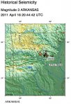
MAP 3.0 2011/04/16 20:44:42 35.349 -92.667 2.8 ARKANSAS
* 21 km (13 miles) N (354°) from Plumerville, AR
* 22 km (14 miles) NNE (18°) from Morrilton, AR
* 22 km (14 miles) W (279°) from Twin Groves, AR
* 75 km (46 miles) NNW (336°) from Little Rock, AR
* 423 km (263 miles) SSW (211°) from St. Louis, MO
I'm posting this mainly to record the info as I watch what develops over the coming weeks.
Please, people, let's don't try to connect this to the New Madrid. It is NOT part of the New Madrid fault system. If you want to talk about the New Madrid, please start another thread.
There was a 3.0 magnitude eq yesterday in a whole new area, completely removed from the area where the recent swarm activity has been taking place. I'm not aware of there ever being eq activity in this area before now.
I'm sure it's just a coincidence that the fricking fracking operations have just opened up in that area. <sarcasm off>
MAP 3.0 2011/04/16 20:44:42 35.349 -92.667 2.8 ARKANSAS
* 21 km (13 miles) N (354°) from Plumerville, AR
* 22 km (14 miles) NNE (18°) from Morrilton, AR
* 22 km (14 miles) W (279°) from Twin Groves, AR
* 75 km (46 miles) NNW (336°) from Little Rock, AR
* 423 km (263 miles) SSW (211°) from St. Louis, MO
I'm posting this mainly to record the info as I watch what develops over the coming weeks.
Please, people, let's don't try to connect this to the New Madrid. It is NOT part of the New Madrid fault system. If you want to talk about the New Madrid, please start another thread.