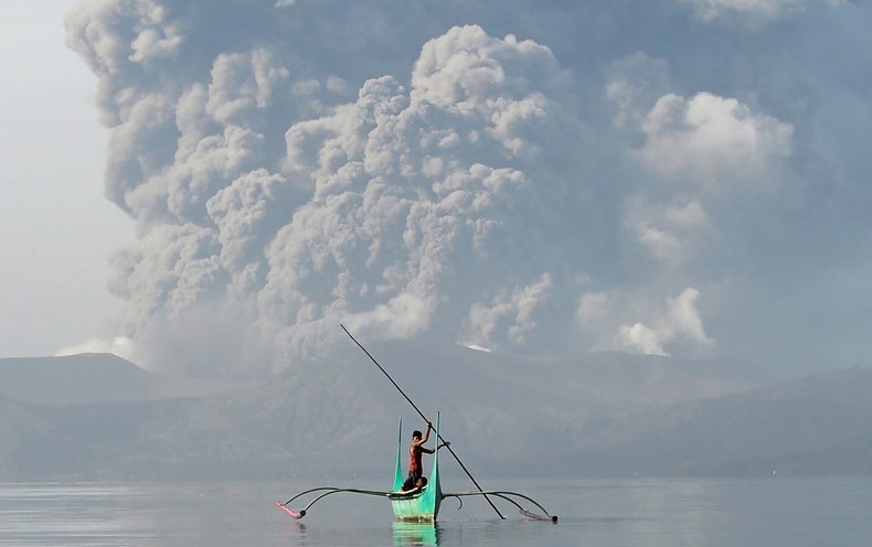
Misc Alert level raised in the Philippines as Taal Volcano erupts UPDATE: now level 4

Heliobas Disciple

TB Fanatic
(fair use applies)

Alert level raised in the Philippines as Taal Volcano erupts, prompts evacuations
By Renee Duff, AccuWeather meteorologist
Updated jan. 12, 2020 3:18 AM

The Taal Volcano in the central Philippines rumbled to life on Sunday, spewing ash and prompting evacuations in nearby communities. The volcano is located on the island of Luzon and is the country's second most active volcano.

The Philippine Institute of Volcanology and Seismology (PHIVOLCS) raised the status of the Taal Volcano from Alert Level 1 to Alert Level 2 at 2:30 p.m. Sunday, local time, indicating a moderate level of volcanic unrest. This was upgraded less than two hours later to an Alert Level 3, indicating a high level of volcanic unrest. The alert system has five levels with Alert Level 5 meaning a hazardous eruption is in progress.

"Taal Volcano Main Crater has escalated its eruptive activity, generating an eruption plume 1 km [3,280 feet] high accompanied by volcanic tremor and felt earthquakes in Volcano Island and barangays of Agoncillo, Batanga. Ashfall is currently being showered on the southwest sector of Taal," PHIVOLCS said in a statement.

"The public is reminded that the Main Crater should be strictly off-limits because sudden steam explosions can occur and high concentrations of lethal volcanic gases can be released," they added. "In addition, communities around the Taal Lake shore are advised to take precautionary measures and be vigilant of possible lakewater disturbances related to the ongoing unrest."
Ongoing phreatic explosion at the Main Crater of Taal Volcano. Photos taken from installed IP camera monitoring the activity of Taal Volcano. pic.twitter.com/9Qyd7aLvsJ
— PHIVOLCS-DOST (@phivolcs_dost) January 12, 2020
Cameras monitoring the volcano caught ash spewing from the crater around the midday hours of Sunday.

Evacuations are underway for an unknown number of people in the municipalities of San Nicolas, Balete and Talisay, according to The Philippine Star.
JUST IN: Taal Volcano erupts on Sunday afternoon. | Video courtesy of Veronica Mercado pic.twitter.com/uWEYlVJ94j
— The Philippine Star (@PhilippineStar) January 12, 2020
A moderate to high level of seismic activity has been observed in the vicinity since March 28, 2019, according to PHIVOLCS. The agency reported three earthquake events as of early Sunday afternoon.

"A seismic swarm has started at around 11:00 a.m. and ongoing as of 2:10 p.m.," PHIVOLCS said.

The last major eruption of the Taal Volcano occurred in 1977.
 
Last edited:

Heliobas Disciple

TB Fanatic
CNN Philippines @cnnphilippines
40m
BREAKING: A ‘hazardous eruption’ of Taal Volcano is imminent, PHIVOLCS says as it raises Alert Level 4


Thanks, I updated the thread title to reflect the raised level. Here's an updated article as well:

Small but dangerous: volcano spews ash over Philippine capital
By Enrico Dela Cruz and Karen Lema
Sunday, 12 January 2020 17:39 GMT

Thousands evacuated amid warnings of a possible explosive eruption and volcanic tsunami
* About 8,000 residents ordered to evacuate
* Authorities warn of "volcanic tsunami" in lake
* Ash fall also prompts class, flight suspensions
* Roads, cars in capital covered in ash


MANILA, Jan 12 (Reuters) - A volcano near Manila spewed a massive cloud of ash that drifted across the Philippine capital on Sunday, forcing the cancellation of flights and closure of schools and government offices as authorities warned of a possible "explosive eruption".

Thousands of people were evacuated from the area near Taal volcano after it suddenly shot a column of ash and steam as high as 15 km (nine miles) into the sky. Lightning crackled inside the smoke and tremors shook the ground.

Taal, one of the world's smallest active volcanoes, sits in the middle of a lake about 70 km (45 miles) south of the centre of the capital, Manila. Authorities said there was a risk that an eruption could cause a tsunami in the lake.

"Taal is a very small volcano, but a dangerous volcano," Renato Solidum, head of The Philippine Institute of Volcanology and Seismology (Phivolcs), told Reuters. "It is unique because it is a volcano within a volcano."

The institute raised the danger level posed by the volcano to 4 out of a possible 5 - meaning "hazardous explosive eruption is possible within hours to days."

The Philippines lies on the "Ring of Fire," a belt of volcanoes circling the Pacific Ocean that is also prone to earthquakes.
One of the most active volcanoes in the Philippines, Taal has erupted more than 30 times in the past five centuries, most recently in 1977. An eruption in 1911 killed 1,500 people and one in 1754 lasted for a few months.

"That is the worst case scenario," Solidum said.

THOUSANDS EVACUATED

About 8,000 residents of the volcano island and other high-risk towns were being evacuated, with about 6,000 already out of the danger zone by Sunday evening, the National Disaster Risk Reduction and Management Council told reporters.
The volcano and its surroundings are a popular weekend getaway from Manila.

The drifting ash forced the cancellation of 172 flights in and out of the international airport on Sunday. General Manager Ed Monreal said flights would also be suspended on Monday because there was ash on the runway.

President Rodrigo Duterte's office ordered the suspension of government work in the capital and of all school classes in Manila and other areas affected by the ash. A statement advised private companies to follow suit.

In Manila, long queues formed in shops selling face masks as health officials warned of possible breathing problems for people with respiratory ailments and urged the public to stay indoors and use dust masks when going out.

"When I went to my car to bring my groceries, I saw it was covered in ash. So I hurriedly went back inside to
buy a mask from a drugstore but they had run out," said Angel Bautista, 41, a resident of Paranaque city, south of the capital.

Taal's ash plume was clearly visible from the city of Tagaytay, a well-frequented viewing spot for the volcano.
"We were having lunch when we heard rumbling. We saw the volcano erupting. It rained and some small pebbles fell to the ground," Jon Patrick Yen, a restaurant customer in Tagaytay, told Reuters.

"I did not expect to see such spectacle. We just went by to eat."
 

Heliobas Disciple

TB Fanatic
I have a thread on this topic as well, if the mods could merge the threads! Thanks.
I'm not sure why the threads weren't merged, here's a link to your thread on MAIN which had other articles and comments for anyone interested.


Latest update:

(fair use applies)

Deadly calm: Main crater lake drained of water
posted January 16, 2020 at 01:25 am by Rio N. Araja

A destructive and deadly eruption could still be in the works even though Taal Volcano appeared calm on Wednesday, the Philippine Institute of Volcanology and Seismology said.

“The explosive eruption scenario and this is the scenario we have been preparing for together with the Batangas Provincial Risk Reduction and Management Office, is still possible simply because… we still have a lot of earthquakes and ground deformation within the area,” PHIVOLCS director Renato Solidum said in an interview on ANC Headstart.

The agency also said the volcano’s continued activity has drained its main crater lake of water, as seen in new satellite images and drone video footage.p

Mariton Bornas, chief of PHIVOLCS’ Monitoring and Eruption Prediction Division, said the dried lake was related to the movement of magma up the volcano but said it was not a sign for an explosive volcanic eruption.

The lake’s waters had receded and dried up portions of Pagsipit River, the lake’s only drainage outlet, owing to the continuous volcanic earthquakes, Bornas said at a press briefing on Wednesday. This indicated a rise or “uplifting” of the Taal region.

“It’s possible that the cracks seen in Lemery [in Batangas province] go straight to Talisay [the town near the lake]. There could be underwater fissures on the floor of the lake and water has seeped into them,” she added.

In general, this is all related to the ground deformation caused by magma pushing up the volcano, Bornas said.

Meanwhile, the local governments of Lemery, Agoncillo, and Laurel in Batangas province shut off their towns on Wednesday amid continued ashfall from Taal’s Sunday eruption.

Agoncillo Mayor Daniel Reyes told ABS-CBN he ordered a lockdown at 1 p.m., while Laurel Mayor Joan Amo closed the area at 5 p.m.

Lemery Mayor Eulalio Alilio said the town was placed under lockdown at 6 p.m. except Barangays Gulod, Arumahan, Talaga, Payapa Ilaya, Mayasang, Niugan, and some portions of Brgy. Payapa Ibaba.

Paolo Reniva, PHIVOLCS resident volcanologist and Taal Observatory officer in charge, also warned of threats of pyroclastic density currents that could kill people and destroy property along shoreline communities near the volcano island.

In an interview over GMA-7’s Unang Balita, Reniva also told residents of Laurel and Agoncillo municipalities that a volcanic tsunami could ensue.

“A strong eruption could cause some parts of the volcano to collapse and displace the water in it, then the water would plunge into the shorelines,” he said.

Just like the 1965 Taal Volcano eruption, a base surge and volcanic tsunami would affect Laurel and Agoncillo, he added.

PHIVOLCS said a hazardous volcanic eruption is when Taal Volcano would exhibit horizontally moving clouds over 60 kilometers per hour.

According to Solidum, the occurrence of volcanic earthquakes is the primary parameter in raising the alert level for active volcanoes, such as Taal.

A high level of sulfur dioxide cannot be a good gauge if an explosive eruption could happen soon, he added.

The quakes and ground fissures in several barangays in Batangas indicated the continuous magmatic intrusion beneath the volcano, he said,

While Taal volcano is having a “generally weaker eruption” at the main crater, the cracks within its areas would only mean the volcano is very much active underneath with magma rising, he said.

In its 8 a.m. bulletin, PHIVOLCS said there were 466 volcanic earthquakes recorded since Jan. 12.

New ground fissures or cracks were observed in Lemery’s barangays Sinisian, Mahabang Dahilig, Dayapan, Palanas, Sangalang, Poblacion and Mataas na Bayan; Agoncillo’s barangays Pansipit and Bilibinwang; Talisay’s barangays Poblacion 1, Poblacion 2, Poblacion 3 and Poblacion 5, and San Nicolas’ Barangay Poblacion.

Meanwhile, more military personnel were sent to various areas in Batangas and Cavite provinces to hasten the movement of thousands of displaced residents and support their daily routine following Sunday’s eruption of Taal Volcano.

The additional military forces were deployed to provide humanitarian assistance to thousands of residents who had to be moved to a safer place.

Even Army reservists from the 401st and 402nd Ready Reserve Infantry Battalions of the 4th Regional Community Defense Group of the Army Reserve Command have also been mobilized to assist in crowd control in evacuation centers and help local government units and agencies to distribute relief goods.

“Even before the eruption of Taal Volcano on Sunday afternoon, we already have reservists on the ground monitoring the situation. So, as soon the evacuation efforts started, our reservists were able to immediately provide their assistance,” said Lt. Col. Ruperto B. Chua (Res), Commander of 401st Ready Reserve Infantry Battalion.

Communication equipment were also installed in strategic areas in volcano-affected municipalities to boost the ongoing military humanitarian assistance.
 

packyderms_wife

Neither here nor there.
I read an article earlier on Faceborg, and forgot to post it here, about the risk of a volcanic tsunami because of this particular lake.
 

Heliobas Disciple

TB Fanatic
Here's one article that discusses the possibility of tsunami, there were a few on google.


Will Taal Volcano Explosively Erupt? Here’s What Scientists Are Watching
The seismic rumblings of the Philippines’ second most active volcano hold clues to what it might do

By Andrea Thompson on January 14, 2020

For the more than 500,000 residents of the exclusion zone around the Philippines’ Taal volcano, which began erupting on Sunday, the coming days will be a tense wait to see if the eruption will intensify—threatening lives and property—or sputter out. If activity ramps up, Taal is capable of producing all three of the deadliest volcanic hazards: tsunamis, mudflows, and superheated flows of gas and debris. Volcanoes are notoriously unpredictable, but there are seismic signs and others that geologists will be watching for indications of what this one will do.

Taal is the second most active volcano in the Philippines Islands, which are situated at the confluence of several tectonic plates. Taal’s peak sits at the southern end of the main island of Luzon, about 40 miles south of the nation’s capital, Manila. The entire volcanic complex presents something of a geologic Droste effect (a term used to describe recursive pictures within pictures): a lake fills the main crater, which itself is an island in a larger lake that fills the old caldera that formed after catastrophic eruptions about 500,000 and 100,000 years ago. The volcano has erupted 33 times since 1572—most recently in 1977. Since then, it has seen numerous periods of what volcanologists call unrest—seismic rumblings and up-and-down ground movements indicating that magma and other fluids are shifting below the surface. The quandary for those trying to predict Taal’s next moves is that “sometimes that unrest leads to eruption, and sometimes it doesn’t,” says Michael Manga, a volcanologist at the University of California, Berkeley.

1579157450867.jpeg
Taal Volcano features a lake within a central crater, itself surrounded by a lake that fills the lake’s old caldera. Credit: Taro Hama Getty Images

There are, however, particular signs among the symptoms of unrest that volcanologists can look for in order to shed light on what outcomes are more likely. GPS instruments around the volcano can detect whether the ground is expanding—an indicator that magma, gases or fluids are pushing their way toward the surface, which would suggest the eruption will continue and potentially intensify.

Scientists will also be looking for two types of seismic signals, says Tracy Gregg, a volcanologist at the University of Buffalo. If magma is indeed pushing its way toward the surface—and is doing so through a new pathway—“it does that by breaking the rock, and that makes a particular kind of earthquake,” she explains. If those earthquakes are getting closer to the surface, magma is doing so as well.

The second signal is called harmonic tremor, because “as magma moves through the rock at a certain speed, and if the rock pathway is a certain shape, it makes a note,” just like air being pushed through your throat when you sing, Gregg says. Detecting harmonic tremor “tells us that magma has an established pathway, and it’s moving through that established pathway,” she adds. For many volcanoes, this situation means an eruption is imminent.

During a period of unrest at Taal from 2010 to 2011, Malcolm Johnston, a research geophysicist emeritus at the U.S. Geological Survey, and several of his colleagues serendipitously had instruments in place that could glean more detail about the goings-on under the volcano. They detected fluids or magma moving into a chamber about 1.5 miles below the surface, though that material subsequently retreated, and the volcano settled down. In a 2017 study in the Journal of Volcanology and Geothermal Research that summarized their findings, Johnston and his colleagues suggested the most likely place for the volcano to next erupt was above that chamber—and that seems to be where the current eruption is happening. “It’s right where we expected it would be,” Johnston says. Because of the lava now fountaining from the crater, he suspects that magma pushed its way into that chamber and then toward the surface.

One of the main concerns with Taal is the abundant water in its two lakes and the extensive underground hydrothermal system the magma and lava could potentially interact with. “When water comes into contact with something hot, it flashes into steam. Water turning into steam is an incredibly energetic change” that causes it to expand by a factor of eight, Gregg says. If that change happens in an underground hydrothermal system, the steam can build up until it explodes. “That’s the scary part,” Johnston says. The initial stages of Taal’s current eruption were, in fact, such steam-driven, or phreatic, ones, and they sent ash high into the sky.

The current eruption also carries a tsunami risk because of the lake surrounding it. If part of the volcano’s flank collapses into the lake, it could trigger such a wave. (A similar event happened in late 2018 at Anak Krakatau in Indonesia, killing more than 400 people, though it was bigger than what Taal could likely generate.) Tsunamis can also be triggered by large, superheated currents of volcanic gas, ash and other debris—called pyroclastic flows—or by mudflows caused as volcanic ash mixes with abundant water. Both of these occurrences can be devastating in their own right, because they can hurtle down slopes much more quickly than the lava people tend to associate with volcanoes.

Authorities in the Philippines have warned that an explosive eruption could happen within hours or days, and they are working to evacuate nearby residents. But volcanologists cannot say for sure if such an event is imminent or “if this is just boiling off a little steam, like a pot boiling over on a stove,” Gregg says. “We’ve just got to keep watching.”
 
Last edited:

Heliobas Disciple

TB Fanatic
(fair use applies)

Philippine officials warn of another eruption
6 hours ago

Officials in the Philippines are warning people to remain on alert for another eruption at a volcano near Manila as activity appears to be continuous.

An eruption occurred on Sunday at the Taal volcano on Luzon Island, about 60 kilometers south of Manila.

Authorities say about 43,000 people were forced to evacuate to shelters, and a wide range of agricultural products were damaged due to large amounts of ash that accumulated near the foot of the mountain.

The Philippine Institute of Volcanology and Seismology said on Wednesday that numerous cracks in the ground were observed in areas near the volcano.

Nagoya University Graduate School Professor Hiroyuki Kumagai has suggested that the cracks could be due to magma rising underground.


Officials at the Philippine Institute are maintaining their alert at the second highest level of four as more than 500 volcanic earthquakes have been observed and another large eruption could occur.
 
Top