WEATHER Severe Weather the Week of May 6th, 2024

Donna_in_OK

Veteran Member
In my area, the morning had been very overcast and cool. Suddenly, the winds have shifted, the skies have cleared (somewhat), and the sun is shining. Since the sun is now quickly raising the temperatures, the storms will have more fuel.

Either a PDS has been issued for the tornadoes or it will be soon. Just waiting on NWC Norman to throw it out and the local weather guys/gals make it official. PDS = "particularly dangerous situation."

Big thing of homemade mac-n-cheese made, pulled pork is in the crock pot. Cookies about to go in. I'll have pork chops tonight for dinner. Possibly make some chicken salad. Quick and easy for the next couple of days for sure.

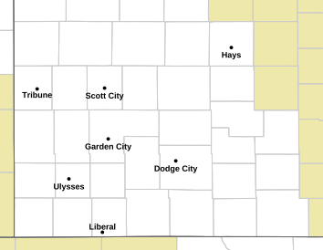
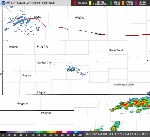
Right now, from current radar view -- a line is starting in Kansas and Nebraska. It'll just get stronger as the line forms further south.

I have a feeling it is going to be a wild ride tonight.
 

somdwatcher

Veteran Member
The storms are definitely expected to form now and over the next few hours over Kansas, Nebraska and other spots north of Oklahoma. Maybe a renegade storm or two by late afternoon over Oklahoma. Instability is going to increase over Oklahoma, even with limited sunshine. But it is expected that 2500-4000 j/kg MLCAPE is going to be common across Oklahoma by sunset. I truly wish ALL of our Oklahoma and southern Kansas members to have an uneventful evening. Any storm that gets going in the environment, this evening has the potential to be catastrophic. Wind shear is expected to rapidly increase with the low level jet and mid level jet streak spreading over Oklahoma this evening.
 

packyderms_wife

Neither here nor there.
South Dakota


Severe Weather Statement
National Weather Service Rapid City SD
1256 PM MDT Mon May 6 2024

SDC019-063-061915-
/O.CON.KUNR.TO.W.0001.000000T0000Z-240506T1915Z/
Harding SD-Butte SD-
1256 PM MDT Mon May 6 2024

...A TORNADO WARNING REMAINS IN EFFECT UNTIL 115 PM MDT FOR
SOUTHEASTERN HARDING AND NORTHEASTERN BUTTE COUNTIES...

At 1256 PM MDT, a confirmed tornado was located 5 miles east of Dears
Ears Butte, or 44 miles northeast of Belle Fourche, moving north at
30 mph.

HAZARD...Damaging tornado.

SOURCE...Weather spotters confirmed tornado.

IMPACT...Flying debris will be dangerous to those caught without
shelter. Mobile homes will be damaged or destroyed. Damage
to roofs, windows, and vehicles will occur. Tree damage is
likely.

This tornado will be near...
Hoover around 100 PM MDT.
Sheep Buttes around 105 PM MDT.

PRECAUTIONARY/PREPAREDNESS ACTIONS...

To repeat, a tornado is on the ground. TAKE COVER NOW! Move to a
basement or an interior room on the lowest floor of a sturdy
building. Avoid windows. If you are outdoors, in a mobile home, or in
a vehicle, move to the closest substantial shelter and protect
yourself from flying debris.

&&

LAT...LON 4485 10299 4484 10311 4524 10340 4532 10297
TIME...MOT...LOC 1856Z 164DEG 49KT 4502 10308

TORNADO...OBSERVED
MAX HAIL SIZE...<.75 IN

$$

Dye
 

packyderms_wife

Neither here nor there.
South Dakota

Tornado Warning
SDC019-063-061915-
/O.NEW.KUNR.TO.W.0001.240506T1848Z-240506T1915Z/

BULLETIN - EAS ACTIVATION REQUESTED
Tornado Warning
National Weather Service Rapid City SD
1248 PM MDT Mon May 6 2024

The National Weather Service in Rapid City has issued a

* Tornado Warning for...
Southeastern Harding County in northwestern South Dakota...
Northeastern Butte County in northwestern South Dakota...

* Until 115 PM MDT.

* At 1248 PM MDT, a severe thunderstorm capable of producing a
tornado was located 10 miles southeast of Dears Ears Butte, or 41
miles northeast of Sturgis, moving north at 55 mph.

HAZARD...Tornado.

SOURCE...Radar indicated rotation.

IMPACT...Flying debris will be dangerous to those caught without
shelter. Mobile homes will be damaged or destroyed.
Damage to roofs, windows, and vehicles will occur. Tree
damage is likely.

* This dangerous storm will be near...
Hoover and Dears Ears Butte around 1255 PM MDT.

PRECAUTIONARY/PREPAREDNESS ACTIONS...

TAKE COVER NOW! Move to a basement or an interior room on the lowest
floor of a sturdy building. Avoid windows. If you are outdoors, in a
mobile home, or in a vehicle, move to the closest substantial shelter
and protect yourself from flying debris.

&&

LAT...LON 4482 10296 4481 10310 4524 10340 4532 10297
TIME...MOT...LOC 1848Z 164DEG 49KT 4491 10304

TORNADO...RADAR INDICATED
MAX HAIL SIZE...<.75 IN

$$

Dye
 

Donna_in_OK

Veteran Member
They just said on Channel 5 in OKC that the tornado threat today is the worse that they have seen for at least 5 years.


Edited to add: They expect the first line around OKC to fire up around 5pm, but that line will NOT be as severe as the one that will be kicking off just west of Alva about that same time.


May try to get outside and film some of the skies. :D
 

somdwatcher

Veteran Member
PDS Tornado watch issued now.

URGENT - IMMEDIATE BROADCAST REQUESTED
Tornado Watch Number 189
NWS Storm Prediction Center Norman OK
200 PM CDT Mon May 6 2024

The NWS Storm Prediction Center has issued a

* Tornado Watch for portions of
Southern Kansas
Western and Central Oklahoma
Western North Texas

* Effective this Monday afternoon and evening from 200 PM until
1100 PM CDT.

...THIS IS A PARTICULARLY DANGEROUS SITUATION...

* Primary threats include...
Numerous tornadoes expected with a few intense tornadoes likely
Widespread large hail and scattered very large hail events to 4
inches in diameter likely
Scattered damaging winds and isolated significant gusts to 75
mph likely

SUMMARY...Explosive thunderstorm development is forecast this
afternoon along and east of a north to south oriented dryline.
Given a very favorable environment for severe thunderstorms, intense
supercells are expected to evolve. These storms are forecast to
move east across the Watch area this afternoon through the late
evening. The possibility exists for regenerative supercell
development over central Oklahoma this evening. Initially large to
giant hail is forecast with the initial supercell activity before
the tornado risk increases. Intense tornadoes are probable
especially as the atmosphere becomes very favorable for tornadoes
late this afternoon and continuing through the evening.

The tornado watch area is approximately along and 105 statute miles
east and west of a line from 25 miles north northwest of Hutchinson
KS to 50 miles south southeast of Fort Sill OK. For a complete
depiction of the watch see the associated watch outline update
(WOUS64 KWNS WOU9).

PRECAUTIONARY/PREPAREDNESS ACTIONS...

REMEMBER...A Tornado Watch means conditions are favorable for
tornadoes and severe thunderstorms in and close to the watch
area. Persons in these areas should be on the lookout for
threatening weather conditions and listen for later statements
and possible warnings.

&&

OTHER WATCH INFORMATION...CONTINUE...WW 187...WW 188...

AVIATION...Tornadoes and a few severe thunderstorms with hail
surface and aloft to 4 inches. Extreme turbulence and surface wind
gusts to 65 knots. A few cumulonimbi with maximum tops to 500. Mean
storm motion vector 24035.

...Smith


Red Baron

Paleo-Conservative
_______________
PDS Tornado watch issued now.

URGENT - IMMEDIATE BROADCAST REQUESTED
Tornado Watch Number 189
NWS Storm Prediction Center Norman OK
200 PM CDT Mon May 6 2024

The NWS Storm Prediction Center has issued a

* Tornado Watch for portions of
Southern Kansas
Western and Central Oklahoma
Western North Texas

* Effective this Monday afternoon and evening from 200 PM until
1100 PM CDT.

...THIS IS A PARTICULARLY DANGEROUS SITUATION...

* Primary threats include...
Numerous tornadoes expected with a few intense tornadoes likely
Widespread large hail and scattered very large hail events to 4
inches in diameter likely
Scattered damaging winds and isolated significant gusts to 75
mph likely

SUMMARY...Explosive thunderstorm development is forecast this
afternoon along and east of a north to south oriented dryline.
Given a very favorable environment for severe thunderstorms, intense
supercells are expected to evolve. These storms are forecast to
move east across the Watch area this afternoon through the late
evening. The possibility exists for regenerative supercell
development over central Oklahoma this evening. Initially large to
giant hail is forecast with the initial supercell activity before
the tornado risk increases. Intense tornadoes are probable
especially as the atmosphere becomes very favorable for tornadoes
late this afternoon and continuing through the evening.

The tornado watch area is approximately along and 105 statute miles
east and west of a line from 25 miles north northwest of Hutchinson
KS to 50 miles south southeast of Fort Sill OK. For a complete
depiction of the watch see the associated watch outline update
(WOUS64 KWNS WOU9).

PRECAUTIONARY/PREPAREDNESS ACTIONS...

REMEMBER...A Tornado Watch means conditions are favorable for
tornadoes and severe thunderstorms in and close to the watch
area. Persons in these areas should be on the lookout for
threatening weather conditions and listen for later statements
and possible warnings.

&&

OTHER WATCH INFORMATION...CONTINUE...WW 187...WW 188...

AVIATION...Tornadoes and a few severe thunderstorms with hail
surface and aloft to 4 inches. Extreme turbulence and surface wind
gusts to 65 knots. A few cumulonimbi with maximum tops to 500. Mean
storm motion vector 24035.

...Smith

That sounds Pretty Darn Serious . . . ;)
 

packyderms_wife

Neither here nor there.
South Dakota

Severe Weather Statement
National Weather Service Rapid City SD
121 PM MDT Mon May 6 2024

SDC019-061945-
/O.CON.KUNR.TO.W.0002.000000T0000Z-240506T1945Z/
Butte SD-
121 PM MDT Mon May 6 2024

...A TORNADO WARNING REMAINS IN EFFECT UNTIL 145 PM MDT FOR
NORTHEASTERN BUTTE COUNTY...

At 121 PM MDT, a severe thunderstorm capable of producing a tornado
was located 4 miles northeast of Dears Ears Butte, or 40 miles
southeast of Buffalo, moving northwest at 25 mph.

HAZARD...Tornado.

SOURCE...Radar indicated rotation.

IMPACT...Flying debris will be dangerous to those caught without
shelter. Mobile homes will be damaged or destroyed. Damage
to roofs, windows, and vehicles will occur. Tree damage is
likely.

This tornadic thunderstorm will remain over mainly rural areas of
northeastern Butte County.

PRECAUTIONARY/PREPAREDNESS ACTIONS...

TAKE COVER NOW! Move to a basement or an interior room on the lowest
floor of a sturdy building. Avoid windows. If you are outdoors, in a
mobile home, or in a vehicle, move to the closest substantial shelter
and protect yourself from flying debris.

&&

LAT...LON 4503 10309 4502 10317 4521 10336 4521 10307
TIME...MOT...LOC 1921Z 152DEG 30KT 4506 10315

TORNADO...RADAR INDICATED
MAX HAIL SIZE...<.75 IN

$$

Dye
 

anna43

Veteran Member
The only reason to stay in your tornado shelter for long enough to play board games is if your house is destroyed and you have nowhere else to go. You get a warning, you take shelter and pray it's not going to happen. Tornados generally move quickly so its duck and cover and then come out to see what's left. Make sure everyone has on sturdy shoes because if it does hit, you'll need them.
 

Safetydude

Senior Member
May 3rd 1999 was a big outbreak in same area. Highest F-5 tornado winds ever recorded hit between Bridgecreek and Moore Oklahoma. Spent 5 weeks there with FEMA as a DSO. Incredible destruction, sod pulled off ground, asphalt roads lifted and torn away, bottom plates of walls ripped off slabs, full water tower ripped from its piers and toppled. Ironically, we're just over the 25 year aniversary of that Moore tornado with a similar situation developing today. Be safe and hit the storm shelter or get out of harms way if F-4/F-5 twisters spin up.
 

Donna_in_OK

Veteran Member
May 3rd 1999 was a big outbreak in same area. Highest F-5 tornado winds ever recorded hit between Bridgecreek and Moore Oklahoma. Spent 5 weeks there with FEMA as a DSO. Incredible destruction, sod pulled off ground, asphalt roads lifted and torn away, bottom plates of walls ripped off slabs, full water tower ripped from its piers and toppled. Ironically, we're just over the 25 year aniversary of that Moore tornado with a similar situation developing today. Be safe and hit the storm shelter or get out of harms way if F-4/F-5 twisters spin up.
Now THAT was a wild ride....
 

Millwright

Knuckle Dragger
_______________
Fairly healthy storm line in central Ne. And building on the south end into Kansas.

Dunno if that's "it" or will we see more more formation behind it.
 

packyderms_wife

Neither here nor there.
Kansas

Tornado Warning
KSC145-185-062130-
/O.NEW.KDDC.TO.W.0006.240506T2045Z-240506T2130Z/

BULLETIN - EAS ACTIVATION REQUESTED
Tornado Warning
National Weather Service Dodge City KS
345 PM CDT Mon May 6 2024

The National Weather Service in Dodge City has issued a

* Tornado Warning for...
Eastern Pawnee County in south central Kansas...
Northwestern Stafford County in south central Kansas...

* Until 430 PM CDT.

* At 345 PM CDT, a severe thunderstorm capable of producing a tornado
was located near Zook, moving northeast at 35 mph.

HAZARD...Tornado and hail up to two inches in diameter.

SOURCE...Radar indicated rotation.

IMPACT...Flying debris will be dangerous to those caught without
shelter. Mobile homes will be damaged or destroyed.
Damage to roofs, windows, and vehicles will occur. Tree
damage is likely.

* This dangerous storm will be near...
Larned around 350 PM CDT.

PRECAUTIONARY/PREPAREDNESS ACTIONS...

TAKE COVER NOW! Move to a basement or an interior room on the lowest
floor of a sturdy building. Avoid windows. If you are outdoors, in a
mobile home, or in a vehicle, move to the closest substantial shelter
and protect yourself from flying debris.

&&

LAT...LON 3819 9869 3800 9908 3800 9917 3807 9925
3835 9904 3826 9903 3826 9882
TIME...MOT...LOC 2045Z 217DEG 31KT 3807 9913

TORNADO...RADAR INDICATED
MAX HAIL SIZE...2.00 IN

$$

SPRINGER
 

packyderms_wife

Neither here nor there.
ddc.png


Kansas

KDDC_loop.gif
 

packyderms_wife

Neither here nor there.
Oklahoma

Tornado Warning
OKC003-093-151-153-062215-
/O.NEW.KOUN.TO.W.0094.240506T2133Z-240506T2215Z/

BULLETIN - EAS ACTIVATION REQUESTED
Tornado Warning
National Weather Service Norman OK
433 PM CDT Mon May 6 2024

The National Weather Service in Norman has issued a

* Tornado Warning for...
Southeastern Woods County in northwestern Oklahoma...
Southwestern Alfalfa County in northwestern Oklahoma...
Northwestern Major County in northwestern Oklahoma...
East central Woodward County in northwestern Oklahoma...

* Until 515 PM CDT.

* At 433 PM CDT, a severe thunderstorm capable of producing a tornado
was located 4 miles northwest of Quinlan, moving east at 40 mph.

HAZARD...Tornado and golf ball size hail.

SOURCE...Radar indicated rotation.

IMPACT...Flying debris will be dangerous to those caught without
shelter. Mobile homes will be damaged or destroyed.
Damage to roofs, windows, and vehicles will occur. Tree
damage is likely.

* Locations impacted include...
Alva, Waynoka, Dacoma, Quinlan, Avard, and Hopeton.

PRECAUTIONARY/PREPAREDNESS ACTIONS...

TAKE COVER NOW! Move to a storm shelter, safe room or an interior
room on the lowest floor of a sturdy building. Avoid windows. If you
are outdoors, in a mobile home, or in a vehicle, move to the closest
substantial shelter and protect yourself from flying debris.

&&

LAT...LON 3643 9917 3655 9923 3683 9864 3666 9854
3644 9850
TIME...MOT...LOC 2133Z 248DEG 37KT 3649 9912

TORNADO...RADAR INDICATED
MAX HAIL SIZE...1.75 IN

$$

Bunker
 

packyderms_wife

Neither here nor there.
Tennessee

Severe Weather Statement
National Weather Service Nashville TN
430 PM CDT Mon May 6 2024

TNC041-185-062200-
/O.CON.KOHX.TO.W.0002.000000T0000Z-240506T2200Z/
De Kalb TN-White TN-
430 PM CDT Mon May 6 2024

...A TORNADO WARNING REMAINS IN EFFECT UNTIL 500 PM CDT FOR EAST
CENTRAL DE KALB AND NORTHWESTERN WHITE COUNTIES...

At 430 PM CDT, a confirmed tornado was located over Smithville,
moving east at 25 mph.

HAZARD...Damaging tornado.

SOURCE...Radar confirmed tornado.

IMPACT...Flying debris will be dangerous to those caught without
shelter. Mobile homes will be damaged or destroyed. Damage
to roofs, windows, and vehicles will occur. Tree damage is
likely.

This tornado will be near...
Smithville around 435 PM CDT.

Other locations impacted by this tornadic thunderstorm include Bakers
Crossroads.

PRECAUTIONARY/PREPAREDNESS ACTIONS...

To repeat, a tornado is on the ground. TAKE COVER NOW! Move to a
basement or an interior room on the lowest floor of a sturdy
building. Avoid windows. If you are outdoors, in a mobile home, or in
a vehicle, move to the closest substantial shelter and protect
yourself from flying debris.

&&

LAT...LON 3605 8550 3589 8550 3593 8585 3601 8586
3603 8567 3601 8565 3602 8565 3602 8564
3604 8562
TIME...MOT...LOC 2130Z 270DEG 20KT 3597 8581

TORNADO...OBSERVED
MAX HAIL SIZE...<.75 IN

$$

Clements
 

packyderms_wife

Neither here nor there.
Nebraska

Severe Weather Statement
National Weather Service Hastings NE
438 PM CDT Mon May 6 2024

NEC129-181-062147-
/O.EXP.KGID.TO.W.0020.000000T0000Z-240506T2145Z/
Nuckolls NE-Webster NE-
438 PM CDT Mon May 6 2024

...THE TORNADO WARNING FOR NORTHWESTERN NUCKOLLS AND NORTHEASTERN
WEBSTER COUNTIES WILL EXPIRE AT 445 PM CDT...

The tornado threat has diminished and the Tornado Warning has been
cancelled. However, large hail and damaging winds and embedded
tornadoes in the squall line remain possible and a Severe
Thunderstorm Warning remains in effect for the area.

A Tornado Watch remains in effect until 700 PM CDT for south central
Nebraska.


&&

LAT...LON 4022 9825 4031 9838 4035 9836 4035 9834
4027 9815
TIME...MOT...LOC 2137Z 212DEG 28KT 4030 9827

$$

Billings Wright
 

packyderms_wife

Neither here nor there.
Tennessee

Tornado Warning
TNC185-062230-
/O.NEW.KOHX.TO.W.0003.240506T2157Z-240506T2230Z/

BULLETIN - EAS ACTIVATION REQUESTED
Tornado Warning
National Weather Service Nashville TN
457 PM CDT Mon May 6 2024

The National Weather Service in Nashville has issued a

* Tornado Warning for...
Central White County in Middle Tennessee...

* Until 530 PM CDT.

* At 457 PM CDT, a severe thunderstorm capable of producing a tornado
was located 7 miles west of Sparta, moving east at 20 mph.

HAZARD...Tornado and quarter size hail.

SOURCE...Radar indicated rotation.

IMPACT...Flying debris will be dangerous to those caught without
shelter. Mobile homes will be damaged or destroyed.
Damage to roofs, windows, and vehicles will occur. Tree
damage is likely.

* This dangerous storm will be near...
Sparta around 505 PM CDT.

Other locations impacted by this tornadic thunderstorm include Doyle.

PRECAUTIONARY/PREPAREDNESS ACTIONS...

TAKE COVER NOW! Move to a basement or an interior room on the lowest
floor of a sturdy building. Avoid windows. If you are outdoors, in a
mobile home, or in a vehicle, move to the closest substantial shelter
and protect yourself from flying debris.

&&

LAT...LON 3580 8539 3582 8543 3582 8546 3581 8547
3582 8547 3582 8548 3589 8564 3598 8563
3597 8532
TIME...MOT...LOC 2157Z 283DEG 19KT 3593 8560

TORNADO...RADAR INDICATED
MAX HAIL SIZE...1.00 IN

$$

Clements
 

packyderms_wife

Neither here nor there.
Oklahoma

Tornado Warning
OKC003-093-151-153-062245-
/O.NEW.KOUN.TO.W.0095.240506T2154Z-240506T2245Z/

BULLETIN - EAS ACTIVATION REQUESTED
Tornado Warning
National Weather Service Norman OK
454 PM CDT Mon May 6 2024

The National Weather Service in Norman has issued a

* Tornado Warning for...
Southeastern Woods County in northwestern Oklahoma...
Southwestern Alfalfa County in northwestern Oklahoma...
Western Major County in northwestern Oklahoma...
Southeastern Woodward County in northwestern Oklahoma...

* Until 545 PM CDT.

* At 454 PM CDT, a severe thunderstorm capable of producing a tornado
was located 4 miles east of Mutual, moving east at 45 mph.

HAZARD...Tornado and golf ball size hail.

SOURCE...Radar indicated rotation.

IMPACT...Flying debris will be dangerous to those caught without
shelter. Mobile homes will be damaged or destroyed.
Damage to roofs, windows, and vehicles will occur. Tree
damage is likely.

* Locations impacted include...
Fairview, Mutual, Chester, Orion, and Bouse Junction.

PRECAUTIONARY/PREPAREDNESS ACTIONS...

TAKE COVER NOW! Move to a storm shelter, safe room or an interior
room on the lowest floor of a sturdy building. Avoid windows. If you
are outdoors, in a mobile home, or in a vehicle, move to the closest
substantial shelter and protect yourself from flying debris.

&&

LAT...LON 3618 9847 3616 9913 3616 9916 3632 9922
3655 9849
TIME...MOT...LOC 2154Z 250DEG 37KT 3624 9909

TORNADO...RADAR INDICATED
MAX HAIL SIZE...1.75 IN

$$

Bunker
 
Top