
You are using an out of date browser. It may not display this or other websites correctly.
You should upgrade or use an alternative browser.
You should upgrade or use an alternative browser.
WEATHER Severe Weather the Week of May 6th, 2024
- Thread starter packyderms_wife
- Start date
straightstreet
Life is better in flip flops
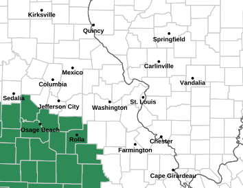
We live in the red zone on the map above. Schools in the area are letting out early. I got a test message both on my phone and by email from our county director of emergency management saying TEST TEST TEST. We had a severe thunderstorm around 8 am this morning. It knocked down trees in our area and our power was out for 2 hours. DS is a paramedic on shift in a neighboring county. I did text him earlier to ask if they had been briefed on the impending weather and he said not so far. I've done alot of praying this morning. We don't have anywhere to go except an interior closet. So if you find it in your heart to pray for us and our family, I'd be so grateful. DD just text that our grandsons school is also sending the kids home. She's in the hospital after giving birth on Monday. Dad is going to meet the bus. Boys have been staying with us this week so we'll need to go the hospital and we will have our grandsons with us.
straightstreet
Life is better in flip flops
packyderms_wife
Neither here nor there.
We live in the red zone on the map above. Schools in the area are letting out early. I got a test message both on my phone and by email from our county director of emergency management saying TEST TEST TEST. We had a severe thunderstorm around 8 am this morning. It knocked down trees in our area and our power was out for 2 hours. DS is a paramedic on shift in a neighboring county. I did text him earlier to ask if they had been briefed on the impending weather and he said not so far. I've done alot of praying this morning. We don't have anywhere to go except an interior closet. So if you find it in your heart to pray for us and our family, I'd be so grateful. DD just text that our grandsons school is also sending the kids home. She's in the hospital after giving birth on Monday. Dad is going to meet the bus. Boys have been staying with us this week so we'll need to go the hospital and we will have our grandsons with us.
Do the kids have bicycle helmet's or any helmet? If do have dad bring them when he brings the kids. A closet is doable, wearing a helmet is highly recommended during a tornado or derecho.
Prayers for you and your family to stay safe. Prayers for everyone in the path of these storms.We live in the red zone on the map above. Schools in the area are letting out early. I got a test message both on my phone and by email from our county director of emergency management saying TEST TEST TEST. We had a severe thunderstorm around 8 am this morning. It knocked down trees in our area and our power was out for 2 hours. DS is a paramedic on shift in a neighboring county. I did text him earlier to ask if they had been briefed on the impending weather and he said not so far. I've done alot of praying this morning. We don't have anywhere to go except an interior closet. So if you find it in your heart to pray for us and our family, I'd be so grateful. DD just text that our grandsons school is also sending the kids home. She's in the hospital after giving birth on Monday. Dad is going to meet the bus. Boys have been staying with us this week so we'll need to go the hospital and we will have our grandsons with us.
straightstreet
Life is better in flip flops
The youngest GS does have a helmet and it's actually here at our home. The rest of us do not. We're going to the hospital so dad doesn't have to leave our DD. He's just making the bus stop pick up instead of us. They're a 30 minute drive from us.Do the kids have bicycle helmet's or any helmet? If do have dad bring them when he brings the kids. A closet is doable, wearing a helmet is highly recommended during a tornado or derecho.
WanderLore
Veteran Member
We are in SW Hillsdale county, MI. We had a confirmed large tornado heading right at us.
I went out had a look, put the chickens back. Horses went in barn. I was cooking dinner.
The cells split just before they got to us, like a mile north and a mile south.
Son at station 5 miles away, they reported a funnel over them. He called to warn us.
We got a pretty good storm. No twister. Had a nice dinner.
packyderms_wife
Neither here nor there.
Might want to order some helmets for the future, weather is going to be crazy this summer.The youngest GS does have a helmet and it's actually here at our home. The rest of us do not. We're going to the hospital so dad doesn't have to leave our DD. He's just making the bus stop pick up instead of us. They're a 30 minute drive from us.
WanderLore
Veteran Member
We could go in basement, but boy that would have been difficult with Scot on walker. Hand of God, no injures or damage here.
packyderms_wife
Neither here nor there.
Most risk areas are over performing! Yep that was yesterday, the parts of Michigan that got hit weren’t even in the moderate risk area.
packyderms_wife
Neither here nor there.
Missouri
Severe Weather Statement
National Weather Service St Louis MO
1111 AM CDT Wed May 8 2024
MOC055-071-081645-
/O.CON.KLSX.TO.W.0050.000000T0000Z-240508T1645Z/
Crawford MO-Franklin MO-
1111 AM CDT Wed May 8 2024
...A TORNADO WARNING REMAINS IN EFFECT UNTIL 1145 AM CDT FOR NORTHERN
CRAWFORD AND SOUTHWESTERN FRANKLIN COUNTIES...
At 1111 AM CDT, a severe thunderstorm capable of producing a tornado
was located near Cuba, moving east at 40 mph.
HAZARD...Tornado and tennis ball size hail.
SOURCE...Radar indicated rotation.
IMPACT...Flying debris will be dangerous to those caught without
shelter. Mobile homes will be damaged or destroyed. Damage
to roofs, windows, and vehicles will occur. Tree damage is
likely.
Locations impacted include...
Sullivan, Cuba, Bourbon, Leasburg, St. Cloud, and Oak Hill.
This also includes Onondaga Cave State Park and Meramec State Park.
This includes Interstate 44 in Missouri between exits 210 and 228.
PRECAUTIONARY/PREPAREDNESS ACTIONS...
TAKE COVER NOW! Move to a basement or an interior room on the lowest
floor of a sturdy building. Avoid windows. If you are outdoors, in a
mobile home, or in a vehicle, move to the closest substantial shelter
and protect yourself from flying debris.
&&
LAT...LON 3808 9146 3815 9149 3821 9148 3821 9137
3823 9137 3825 9110 3804 9110
TIME...MOT...LOC 1611Z 267DEG 36KT 3815 9139
TORNADO...RADAR INDICATED
MAX HAIL SIZE...2.50 IN
$$
Glass
packyderms_wife
Neither here nor there.
packyderms_wife
Neither here nor there.
RT 10:49 - Max Velocity
In this weather forecast, we are breaking down a VERY CONCERNING storm that will bring MORE significant severe weather today and tomorrow to the United States. This will bring more severe weather like damaging winds, large hail, and tornadoes. Find the latest details of the weather across the United States in our latest weather forecast.
I beatcha toit. Previous pageView: https://www.youtube.com/watch?v=xCbaaOh-Pd4
RT 10:49 - Max Velocity
In this weather forecast, we are breaking down a VERY CONCERNING storm that will bring MORE significant severe weather today and tomorrow to the United States. This will bring more severe weather like damaging winds, large hail, and tornadoes. Find the latest details of the weather across the United States in our latest weather forecast.

packyderms_wife
Neither here nor there.
packyderms_wife
Neither here nor there.
Missouri
Tornado Warning
MOC055-071-221-081715-
/O.NEW.KLSX.TO.W.0051.240508T1635Z-240508T1715Z/
BULLETIN - EAS ACTIVATION REQUESTED
Tornado Warning
National Weather Service St Louis MO
1135 AM CDT Wed May 8 2024
The National Weather Service in St Louis has issued a
* Tornado Warning for...
Northeastern Crawford County in east central Missouri...
Northern Washington County in east central Missouri...
Southeastern Franklin County in east central Missouri...
* Until 1215 PM CDT.
* At 1135 AM CDT, a severe thunderstorm capable of producing a
tornado was located near Sullivan, moving east at 30 mph.
HAZARD...Tornado and quarter size hail.
SOURCE...Radar indicated rotation.
IMPACT...Flying debris will be dangerous to those caught without
shelter. Mobile homes will be damaged or destroyed.
Damage to roofs, windows, and vehicles will occur. Tree
damage is likely.
* Locations impacted include...
Richwoods.
This also includes Washington State Park and Meramec State Park.
PRECAUTIONARY/PREPAREDNESS ACTIONS...
TAKE COVER NOW! Move to a basement or an interior room on the lowest
floor of a sturdy building. Avoid windows. If you are outdoors, in a
mobile home, or in a vehicle, move to the closest substantial shelter
and protect yourself from flying debris.
&&
LAT...LON 3809 9114 3817 9116 3820 9116 3825 9113
3828 9077 3820 9078 3810 9068 3809 9068
3809 9065 3808 9066 3808 9065 3807 9064
TIME...MOT...LOC 1635Z 266DEG 28KT 3815 9114
TORNADO...RADAR INDICATED
MAX HAIL SIZE...1.00 IN
$$
Glass
Tornado Warning
MOC055-071-221-081715-
/O.NEW.KLSX.TO.W.0051.240508T1635Z-240508T1715Z/
BULLETIN - EAS ACTIVATION REQUESTED
Tornado Warning
National Weather Service St Louis MO
1135 AM CDT Wed May 8 2024
The National Weather Service in St Louis has issued a
* Tornado Warning for...
Northeastern Crawford County in east central Missouri...
Northern Washington County in east central Missouri...
Southeastern Franklin County in east central Missouri...
* Until 1215 PM CDT.
* At 1135 AM CDT, a severe thunderstorm capable of producing a
tornado was located near Sullivan, moving east at 30 mph.
HAZARD...Tornado and quarter size hail.
SOURCE...Radar indicated rotation.
IMPACT...Flying debris will be dangerous to those caught without
shelter. Mobile homes will be damaged or destroyed.
Damage to roofs, windows, and vehicles will occur. Tree
damage is likely.
* Locations impacted include...
Richwoods.
This also includes Washington State Park and Meramec State Park.
PRECAUTIONARY/PREPAREDNESS ACTIONS...
TAKE COVER NOW! Move to a basement or an interior room on the lowest
floor of a sturdy building. Avoid windows. If you are outdoors, in a
mobile home, or in a vehicle, move to the closest substantial shelter
and protect yourself from flying debris.
&&
LAT...LON 3809 9114 3817 9116 3820 9116 3825 9113
3828 9077 3820 9078 3810 9068 3809 9068
3809 9065 3808 9066 3808 9065 3807 9064
TIME...MOT...LOC 1635Z 266DEG 28KT 3815 9114
TORNADO...RADAR INDICATED
MAX HAIL SIZE...1.00 IN
$$
Glass
packyderms_wife
Neither here nor there.
I beatcha toit. Previous page
by golly you did, thanks for posting that video! It's gonna be a spicy one today.
packyderms_wife
Neither here nor there.

Missouri/Illinois
packyderms_wife
Neither here nor there.
Missouri
Severe Weather Statement
National Weather Service St Louis MO
1224 PM CDT Wed May 8 2024
MOC071-099-221-081800-
/O.CON.KLSX.TO.W.0052.000000T0000Z-240508T1800Z/
Jefferson MO-Washington MO-Franklin MO-
1224 PM CDT Wed May 8 2024
...A TORNADO WARNING REMAINS IN EFFECT UNTIL 100 PM CDT FOR
JEFFERSON...NORTHEASTERN WASHINGTON AND SOUTHEASTERN FRANKLIN
COUNTIES...
At 1224 PM CDT, a severe thunderstorm capable of producing a tornado
was located near Richwoods, moving east at 25 mph.
HAZARD...Tornado and baseball size hail.
SOURCE...Radar indicated rotation.
IMPACT...Flying debris will be dangerous to those caught without
shelter. Mobile homes will be damaged or destroyed. Damage
to roofs, windows, and vehicles will occur. Tree damage is
likely.
Locations impacted include...
De Soto, Hillsboro, Festus, Olympian Village and Herculaneum.
This also includes Mastodon Historic Site, Sandy Creek Covered Bridge
Historic Site, and Gov. Dunklin`s Grave Historic Site.
This includes Interstate 55 in Missouri between exits 170 and 187.
PRECAUTIONARY/PREPAREDNESS ACTIONS...
TAKE COVER NOW! Move to a basement or an interior room on the lowest
floor of a sturdy building. Avoid windows. If you are outdoors, in a
mobile home, or in a vehicle, move to the closest substantial shelter
and protect yourself from flying debris.
&&
LAT...LON 3809 9085 3834 9094 3839 9036 3837 9035
3834 9037 3830 9037 3824 9036 3819 9034
3816 9028 3811 9026 3811 9028 3809 9029
3809 9033 3807 9037
TIME...MOT...LOC 1724Z 268DEG 21KT 3818 9078
TORNADO...RADAR INDICATED
MAX HAIL SIZE...2.75 IN
$$
Glass
packyderms_wife
Neither here nor there.
Missouri/Illinois
Tornado Warning
ILC133-157-MOC099-186-081845-
/O.NEW.KLSX.TO.W.0053.240508T1756Z-240508T1845Z/
BULLETIN - EAS ACTIVATION REQUESTED
Tornado Warning
National Weather Service St Louis MO
1256 PM CDT Wed May 8 2024
The National Weather Service in St Louis has issued a
* Tornado Warning for...
Monroe County in southwestern Illinois...
Northwestern Randolph County in southwestern Illinois...
Southeastern Jefferson County in east central Missouri...
North central Ste. Genevieve County in southeastern Missouri...
* Until 145 PM CDT.
* At 1256 PM CDT, a severe thunderstorm capable of producing a
tornado was located over Olympian Village, moving east at 35 mph.
HAZARD...Tornado and tennis ball size hail.
SOURCE...Radar indicated rotation.
IMPACT...Flying debris will be dangerous to those caught without
shelter. Mobile homes will be damaged or destroyed.
Damage to roofs, windows, and vehicles will occur. Tree
damage is likely.
* This dangerous storm will be near...
Crystal City and Olympian Village around 100 PM CDT.
This also includes Sandy Creek Covered Bridge Historic Site and Gov.
Dunklin`s Grave Historic Site.
This includes Interstate 55 in Missouri between exits 170 and 180.
PRECAUTIONARY/PREPAREDNESS ACTIONS...
TAKE COVER NOW! Move to a basement or an interior room on the lowest
floor of a sturdy building. Avoid windows. If you are outdoors, in a
mobile home, or in a vehicle, move to the closest substantial shelter
and protect yourself from flying debris.
&&
LAT...LON 3808 9051 3832 9055 3836 9009 3832 9004
3831 9004 3831 9003 3806 9004
TIME...MOT...LOC 1756Z 265DEG 30KT 3813 9046
TORNADO...RADAR INDICATED
MAX HAIL SIZE...2.50 IN
$$
Glass
Tornado Warning
ILC133-157-MOC099-186-081845-
/O.NEW.KLSX.TO.W.0053.240508T1756Z-240508T1845Z/
BULLETIN - EAS ACTIVATION REQUESTED
Tornado Warning
National Weather Service St Louis MO
1256 PM CDT Wed May 8 2024
The National Weather Service in St Louis has issued a
* Tornado Warning for...
Monroe County in southwestern Illinois...
Northwestern Randolph County in southwestern Illinois...
Southeastern Jefferson County in east central Missouri...
North central Ste. Genevieve County in southeastern Missouri...
* Until 145 PM CDT.
* At 1256 PM CDT, a severe thunderstorm capable of producing a
tornado was located over Olympian Village, moving east at 35 mph.
HAZARD...Tornado and tennis ball size hail.
SOURCE...Radar indicated rotation.
IMPACT...Flying debris will be dangerous to those caught without
shelter. Mobile homes will be damaged or destroyed.
Damage to roofs, windows, and vehicles will occur. Tree
damage is likely.
* This dangerous storm will be near...
Crystal City and Olympian Village around 100 PM CDT.
This also includes Sandy Creek Covered Bridge Historic Site and Gov.
Dunklin`s Grave Historic Site.
This includes Interstate 55 in Missouri between exits 170 and 180.
PRECAUTIONARY/PREPAREDNESS ACTIONS...
TAKE COVER NOW! Move to a basement or an interior room on the lowest
floor of a sturdy building. Avoid windows. If you are outdoors, in a
mobile home, or in a vehicle, move to the closest substantial shelter
and protect yourself from flying debris.
&&
LAT...LON 3808 9051 3832 9055 3836 9009 3832 9004
3831 9004 3831 9003 3806 9004
TIME...MOT...LOC 1756Z 265DEG 30KT 3813 9046
TORNADO...RADAR INDICATED
MAX HAIL SIZE...2.50 IN
$$
Glass
packyderms_wife
Neither here nor there.
Tornado Warning
KYC083-139-145-157-081845-
/O.NEW.KPAH.TO.W.0035.240508T1818Z-240508T1845Z/
BULLETIN - EAS ACTIVATION REQUESTED
Tornado Warning
National Weather Service Paducah KY
118 PM CDT Wed May 8 2024
The National Weather Service in Paducah has issued a
* Tornado Warning for...
South central Livingston County in western Kentucky...
Northwestern Marshall County in western Kentucky...
Southeastern McCracken County in western Kentucky...
Northeastern Graves County in western Kentucky...
* Until 145 PM CDT.
* At 118 PM CDT, a severe thunderstorm capable of producing a tornado
was located near Reidland, moving northeast at 25 mph.
HAZARD...Tornado.
SOURCE...Radar indicated rotation.
IMPACT...Flying debris will be dangerous to those caught without
shelter. Mobile homes will be damaged or destroyed.
Damage to roofs, windows, and vehicles will occur. Tree
damage is likely.
* This dangerous storm will be near...
Reidland and Ledbetter around 125 PM CDT.
Other locations impacted by this tornadic thunderstorm include
Symsonia.
This includes the following highways...
Interstate 24 in Kentucky between Mile Markers 14 and 29.
Interstate 69 in Kentucky between Mile Markers 49 and 51.
PRECAUTIONARY/PREPAREDNESS ACTIONS...
TAKE COVER NOW! Move to a basement or an interior room on the lowest
floor of a sturdy building. Avoid windows. If you are outdoors, in a
mobile home, or in a vehicle, move to the closest substantial shelter
and protect yourself from flying debris.
&&
LAT...LON 3688 8848 3690 8856 3697 8859 3712 8838
3700 8826
TIME...MOT...LOC 1818Z 237DEG 20KT 3693 8853
TORNADO...RADAR INDICATED
MAX HAIL SIZE...<.75 IN
$$
JGG
packyderms_wife
Neither here nor there.
Missouri
Tornado Warning
MOC186-187-221-081915-
/O.NEW.KLSX.TO.W.0054.240508T1836Z-240508T1915Z/
BULLETIN - EAS ACTIVATION REQUESTED
Tornado Warning
National Weather Service St Louis MO
136 PM CDT Wed May 8 2024
The National Weather Service in St Louis has issued a
* Tornado Warning for...
Southwestern Ste. Genevieve County in southeastern Missouri...
Southeastern Washington County in east central Missouri...
Western St. Francois County in southeastern Missouri...
* Until 215 PM CDT.
* At 135 PM CDT, a severe thunderstorm capable of producing a tornado
was located near Irondale, moving east at 40 mph.
HAZARD...Tornado and ping pong ball size hail.
SOURCE...Radar indicated rotation.
IMPACT...Flying debris will be dangerous to those caught without
shelter. Mobile homes will be damaged or destroyed.
Damage to roofs, windows, and vehicles will occur. Tree
damage is likely.
* This dangerous storm will be near...
Bismarck, Leadwood, Park Hills, and Irondale around 140 PM CDT.
Desloge around 145 PM CDT.
Farmington around 150 PM CDT.
This also includes St. Joe State Park and Missouri Mines Historic
Site.
PRECAUTIONARY/PREPAREDNESS ACTIONS...
TAKE COVER NOW! Move to a basement or an interior room on the lowest
floor of a sturdy building. Avoid windows. If you are outdoors, in a
mobile home, or in a vehicle, move to the closest substantial shelter
and protect yourself from flying debris.
&&
LAT...LON 3774 9065 3774 9078 3782 9079 3798 9032
3773 9027
TIME...MOT...LOC 1835Z 258DEG 35KT 3779 9069
TORNADO...RADAR INDICATED
MAX HAIL SIZE...1.50 IN
$$
BSH
Tornado Warning
MOC186-187-221-081915-
/O.NEW.KLSX.TO.W.0054.240508T1836Z-240508T1915Z/
BULLETIN - EAS ACTIVATION REQUESTED
Tornado Warning
National Weather Service St Louis MO
136 PM CDT Wed May 8 2024
The National Weather Service in St Louis has issued a
* Tornado Warning for...
Southwestern Ste. Genevieve County in southeastern Missouri...
Southeastern Washington County in east central Missouri...
Western St. Francois County in southeastern Missouri...
* Until 215 PM CDT.
* At 135 PM CDT, a severe thunderstorm capable of producing a tornado
was located near Irondale, moving east at 40 mph.
HAZARD...Tornado and ping pong ball size hail.
SOURCE...Radar indicated rotation.
IMPACT...Flying debris will be dangerous to those caught without
shelter. Mobile homes will be damaged or destroyed.
Damage to roofs, windows, and vehicles will occur. Tree
damage is likely.
* This dangerous storm will be near...
Bismarck, Leadwood, Park Hills, and Irondale around 140 PM CDT.
Desloge around 145 PM CDT.
Farmington around 150 PM CDT.
This also includes St. Joe State Park and Missouri Mines Historic
Site.
PRECAUTIONARY/PREPAREDNESS ACTIONS...
TAKE COVER NOW! Move to a basement or an interior room on the lowest
floor of a sturdy building. Avoid windows. If you are outdoors, in a
mobile home, or in a vehicle, move to the closest substantial shelter
and protect yourself from flying debris.
&&
LAT...LON 3774 9065 3774 9078 3782 9079 3798 9032
3773 9027
TIME...MOT...LOC 1835Z 258DEG 35KT 3779 9069
TORNADO...RADAR INDICATED
MAX HAIL SIZE...1.50 IN
$$
BSH
packyderms_wife
Neither here nor there.
Just ordered a new bicycle helmet for myself off of Amazon since mine has fallen apart, it'll be here on Saturday. Had a good laugh when I noticed that one of the colors was UN Blue!
packyderms_wife
Neither here nor there.
Severe Weather Statement
National Weather Service St Louis MO
220 PM CDT Wed May 8 2024
ILC157-081945-
/O.CON.KLSX.TO.W.0055.000000T0000Z-240508T1945Z/
Randolph IL-
220 PM CDT Wed May 8 2024
...A TORNADO WARNING REMAINS IN EFFECT UNTIL 245 PM CDT FOR EAST
CENTRAL RANDOLPH COUNTY...
At 220 PM CDT, a severe thunderstorm capable of producing a tornado
was located near Chester, moving east at 30 mph.
HAZARD...Tornado and two inch hail.
SOURCE...Radar indicated rotation.
IMPACT...Flying debris will be dangerous to those caught without
shelter. Mobile homes will be damaged or destroyed. Damage
to roofs, windows, and vehicles will occur. Tree damage is
likely.
Locations impacted include...
Chester, Bremen, Steeleville, Percy, Blair, Ellis Grove, Welge,
Roots, and New Palestine.
PRECAUTIONARY/PREPAREDNESS ACTIONS...
TAKE COVER NOW! Move to a basement or an interior room on the lowest
floor of a sturdy building. Avoid windows. If you are outdoors, in a
mobile home, or in a vehicle, move to the closest substantial shelter
and protect yourself from flying debris.
&&
LAT...LON 3793 8963 3793 8986 3797 8994 3801 8999
3807 8995 3811 8962
TIME...MOT...LOC 1920Z 260DEG 24KT 3797 8983
TORNADO...RADAR INDICATED
MAX HAIL SIZE...2.00 IN
$$
Glass
packyderms_wife
Neither here nor there.
Tennessee
Tornado Warning
TNC021-125-081930-
/O.NEW.KOHX.TO.W.0005.240508T1906Z-240508T1930Z/
BULLETIN - EAS ACTIVATION REQUESTED
Tornado Warning
National Weather Service Nashville TN
206 PM CDT Wed May 8 2024
The National Weather Service in Nashville has issued a
* Tornado Warning for...
Central Montgomery County in Middle Tennessee...
Northwestern Cheatham County in Middle Tennessee...
* Until 230 PM CDT.
* At 206 PM CDT, a severe thunderstorm capable of producing a tornado
was located 10 miles south of Clarksville, moving northeast at 15
mph.
HAZARD...Tornado and quarter size hail.
SOURCE...Radar indicated rotation.
IMPACT...Flying debris will be dangerous to those caught without
shelter. Mobile homes will be damaged or destroyed.
Damage to roofs, windows, and vehicles will occur. Tree
damage is likely.
* This dangerous storm will be near...
Clarksville around 210 PM CDT.
Other locations impacted by this tornadic thunderstorm include
Cunningham and Palmyra.
This includes Interstate 24 between mile markers 4 and 17.
PRECAUTIONARY/PREPAREDNESS ACTIONS...
TAKE COVER NOW! Move to a basement or an interior room on the lowest
floor of a sturdy building. Avoid windows. If you are outdoors, in a
mobile home, or in a vehicle, move to the closest substantial shelter
and protect yourself from flying debris.
&&
LAT...LON 3647 8713 3646 8713 3646 8712 3644 8710
3645 8709 3643 8709 3642 8706 3635 8743
3644 8749 3662 8728
TIME...MOT...LOC 1906Z 239DEG 15KT 3642 8739
TORNADO...RADAR INDICATED
MAX HAIL SIZE...1.00 IN
$$
Baggett
Tornado Warning
TNC021-125-081930-
/O.NEW.KOHX.TO.W.0005.240508T1906Z-240508T1930Z/
BULLETIN - EAS ACTIVATION REQUESTED
Tornado Warning
National Weather Service Nashville TN
206 PM CDT Wed May 8 2024
The National Weather Service in Nashville has issued a
* Tornado Warning for...
Central Montgomery County in Middle Tennessee...
Northwestern Cheatham County in Middle Tennessee...
* Until 230 PM CDT.
* At 206 PM CDT, a severe thunderstorm capable of producing a tornado
was located 10 miles south of Clarksville, moving northeast at 15
mph.
HAZARD...Tornado and quarter size hail.
SOURCE...Radar indicated rotation.
IMPACT...Flying debris will be dangerous to those caught without
shelter. Mobile homes will be damaged or destroyed.
Damage to roofs, windows, and vehicles will occur. Tree
damage is likely.
* This dangerous storm will be near...
Clarksville around 210 PM CDT.
Other locations impacted by this tornadic thunderstorm include
Cunningham and Palmyra.
This includes Interstate 24 between mile markers 4 and 17.
PRECAUTIONARY/PREPAREDNESS ACTIONS...
TAKE COVER NOW! Move to a basement or an interior room on the lowest
floor of a sturdy building. Avoid windows. If you are outdoors, in a
mobile home, or in a vehicle, move to the closest substantial shelter
and protect yourself from flying debris.
&&
LAT...LON 3647 8713 3646 8713 3646 8712 3644 8710
3645 8709 3643 8709 3642 8706 3635 8743
3644 8749 3662 8728
TIME...MOT...LOC 1906Z 239DEG 15KT 3642 8739
TORNADO...RADAR INDICATED
MAX HAIL SIZE...1.00 IN
$$
Baggett
packyderms_wife
Neither here nor there.
South Carolina
Severe Weather Statement
National Weather Service Greenville-Spartanburg SC
317 PM EDT Wed May 8 2024
NCC045-071-109-081945-
/O.CON.KGSP.TO.W.0004.000000T0000Z-240508T1945Z/
Lincoln NC-Cleveland NC-Gaston NC-
317 PM EDT Wed May 8 2024
...A TORNADO WARNING REMAINS IN EFFECT UNTIL 345 PM EDT FOR
SOUTHWESTERN LINCOLN...CENTRAL CLEVELAND AND NORTHWESTERN GASTON
COUNTIES...
At 317 PM EDT, a severe thunderstorm capable of producing a tornado
was located 8 miles north of Shelby, or near Fallston, moving east at
30 mph.
HAZARD...Tornado and quarter size hail.
SOURCE...Radar indicated rotation.
IMPACT...Flying debris will be dangerous to those caught without
shelter. Mobile homes will be damaged or destroyed. Damage
to roofs, windows, and vehicles will occur. Tree damage is
likely.
This dangerous storm will be near...
Fallston around 320 PM EDT.
Cherryville and Waco around 330 PM EDT.
Other locations impacted by this tornadic thunderstorm include
Crouse.
PRECAUTIONARY/PREPAREDNESS ACTIONS...
TAKE COVER NOW! Move to a basement or an interior room on the lowest
floor of a sturdy building. Avoid windows. If you are outdoors, in a
mobile home, or in a vehicle, move to the closest substantial shelter
and protect yourself from flying debris.
Please report damaging winds, hail, or flooding to the National
Weather Service by calling toll free, 1, 800, 2 6 7, 8 1 0 1, or by
posting on our Facebook page, or Tweet it using hashtag nwsgsp. Your
message should describe the event and the specific location where it
occurred.
&&
LAT...LON 3533 8161 3551 8154 3541 8120 3536 8121
3524 8139
TIME...MOT...LOC 1917Z 291DEG 24KT 3541 8152
TORNADO...RADAR INDICATED
MAX HAIL SIZE...1.00 IN
$$
TW

Mesoscale Discussion 0703
NWS Storm Prediction Center Norman OK
0150 PM CDT Wed May 08 2024
Areas affected...parts of the Mid-MS...Lower OH...and TN Valleys
Concerning...Tornado Watch 204...206...
Valid 081850Z - 081945Z
The severe weather threat for Tornado Watch 204, 206 continues.
SUMMARY...Very large hail, isolated severe wind gusts, and tornadoes
will remain probable with mature supercells across parts of the
Mid-Mississippi to Lower Ohio and Tennessee Valleys through the rest
of the afternoon.
DISCUSSION...Several supercells are ongoing with two distinct
regimes. An intense, long-track supercell in cluster regime persists
across a part of the Mid-MS Valley, between STL and CGI. Numerous
large hail up to baseball size have been reported during the past
hour. This supercell cluster should continue to evolve east along
the tight instability gradient across southern IL, with potential
for further upscale growth along its southwest flank. Damaging winds
of 70-80 mph, along with attempts at occasional tornadogenesis will
remain possible.
Farther southeast, more discrete supercells continue to
increase/mature. Low-level SRH is relatively greater across
south-central KY into northern Middle TN near/northeast of the
residual outflow from the morning MCS. Low-level flow has become
veered to the southwest per time-series of PAH VWP data, tempering
warm-sector hodograph enlargement. Overall, a mix of all severe
hazards, some of which may be significant, is anticipated in/near
both tornado watches through 22Z.
..Grams.. 05/08/2024
...Please see www.spc.noaa.gov for graphic product...

packyderms_wife
Neither here nor there.
Missouri
Tornado Warning
MOC145-082100-
/O.NEW.KSGF.TO.W.0043.240508T2010Z-240508T2100Z/
BULLETIN - EAS ACTIVATION REQUESTED
Tornado Warning
National Weather Service Springfield MO
310 PM CDT Wed May 8 2024
The National Weather Service in Springfield has issued a
* Tornado Warning for...
Central Newton County in southwestern Missouri...
* Until 400 PM CDT.
* At 310 PM CDT, a severe thunderstorm capable of producing a tornado
was located near Seneca, or 8 miles northwest of Neosho, moving
east at 20 mph.
HAZARD...Tornado and golf ball size hail.
SOURCE...Radar indicated rotation.
IMPACT...Flying debris will be dangerous to those caught without
shelter. Mobile homes will be damaged or destroyed.
Damage to roofs, windows, and vehicles will occur. Tree
damage is likely.
* Locations impacted include...
Neosho, Granby, Diamond, Newtonia, Wentworth, Ritchey, and Racine.
This includes Interstate 49 between mile markers 23 and 29.
PRECAUTIONARY/PREPAREDNESS ACTIONS...
TAKE COVER NOW! Move to a basement or an interior room on the lowest
floor of a sturdy building. Avoid windows. If you are outdoors, in a
mobile home, or in a vehicle, move to the closest substantial shelter
and protect yourself from flying debris.
&&
LAT...LON 3686 9456 3694 9457 3705 9406 3687 9407
TIME...MOT...LOC 2010Z 264DEG 19KT 3690 9452
TORNADO...RADAR INDICATED
MAX HAIL SIZE...1.75 IN
$$
Melto
Tornado Warning
MOC145-082100-
/O.NEW.KSGF.TO.W.0043.240508T2010Z-240508T2100Z/
BULLETIN - EAS ACTIVATION REQUESTED
Tornado Warning
National Weather Service Springfield MO
310 PM CDT Wed May 8 2024
The National Weather Service in Springfield has issued a
* Tornado Warning for...
Central Newton County in southwestern Missouri...
* Until 400 PM CDT.
* At 310 PM CDT, a severe thunderstorm capable of producing a tornado
was located near Seneca, or 8 miles northwest of Neosho, moving
east at 20 mph.
HAZARD...Tornado and golf ball size hail.
SOURCE...Radar indicated rotation.
IMPACT...Flying debris will be dangerous to those caught without
shelter. Mobile homes will be damaged or destroyed.
Damage to roofs, windows, and vehicles will occur. Tree
damage is likely.
* Locations impacted include...
Neosho, Granby, Diamond, Newtonia, Wentworth, Ritchey, and Racine.
This includes Interstate 49 between mile markers 23 and 29.
PRECAUTIONARY/PREPAREDNESS ACTIONS...
TAKE COVER NOW! Move to a basement or an interior room on the lowest
floor of a sturdy building. Avoid windows. If you are outdoors, in a
mobile home, or in a vehicle, move to the closest substantial shelter
and protect yourself from flying debris.
&&
LAT...LON 3686 9456 3694 9457 3705 9406 3687 9407
TIME...MOT...LOC 2010Z 264DEG 19KT 3690 9452
TORNADO...RADAR INDICATED
MAX HAIL SIZE...1.75 IN
$$
Melto
packyderms_wife
Neither here nor there.
Illinois!
Tornado Warning
ILC199-082100-
/O.NEW.KPAH.TO.W.0038.240508T2019Z-240508T2100Z/
BULLETIN - EAS ACTIVATION REQUESTED
Tornado Warning
National Weather Service Paducah KY
319 PM CDT Wed May 8 2024
The National Weather Service in Paducah has issued a
* Tornado Warning for...
Central Williamson County in southern Illinois...
* Until 400 PM CDT.
* At 319 PM CDT, a confirmed large and extremely dangerous tornado
was located near Carterville, moving east at 30 mph.
This is a PARTICULARLY DANGEROUS SITUATION. TAKE COVER NOW!
HAZARD...Damaging tornado.
SOURCE...Weather spotters confirmed tornado.
IMPACT...You are in a life-threatening situation. Flying debris
may be deadly to those caught without shelter. Mobile
homes will be destroyed. Considerable damage to homes,
businesses, and vehicles is likely and complete
destruction is possible.
* The tornado will be near...
Marion around 325 PM CDT.
Pittsburg around 335 PM CDT.
Other locations impacted by this tornadic thunderstorm include
Spillertown.
This includes Interstate 57 in Illinois between Mile Markers 48 and
56.
PRECAUTIONARY/PREPAREDNESS ACTIONS...
To repeat, a large, extremely dangerous and potentially deadly
tornado is on the ground. To protect your life, TAKE COVER NOW! Move
to a basement or an interior room on the lowest floor of a sturdy
building. Avoid windows. If you are outdoors, in a mobile home, or in
a vehicle, move to the closest substantial shelter and protect
yourself from flying debris.
&&
LAT...LON 3768 8881 3762 8915 3770 8915 3781 8886
TIME...MOT...LOC 2019Z 250DEG 25KT 3768 8912
TORNADO...OBSERVED
TORNADO DAMAGE THREAT...CONSIDERABLE
MAX HAIL SIZE...1.75 IN
$$
CN
Tornado Warning
ILC199-082100-
/O.NEW.KPAH.TO.W.0038.240508T2019Z-240508T2100Z/
BULLETIN - EAS ACTIVATION REQUESTED
Tornado Warning
National Weather Service Paducah KY
319 PM CDT Wed May 8 2024
The National Weather Service in Paducah has issued a
* Tornado Warning for...
Central Williamson County in southern Illinois...
* Until 400 PM CDT.
* At 319 PM CDT, a confirmed large and extremely dangerous tornado
was located near Carterville, moving east at 30 mph.
This is a PARTICULARLY DANGEROUS SITUATION. TAKE COVER NOW!
HAZARD...Damaging tornado.
SOURCE...Weather spotters confirmed tornado.
IMPACT...You are in a life-threatening situation. Flying debris
may be deadly to those caught without shelter. Mobile
homes will be destroyed. Considerable damage to homes,
businesses, and vehicles is likely and complete
destruction is possible.
* The tornado will be near...
Marion around 325 PM CDT.
Pittsburg around 335 PM CDT.
Other locations impacted by this tornadic thunderstorm include
Spillertown.
This includes Interstate 57 in Illinois between Mile Markers 48 and
56.
PRECAUTIONARY/PREPAREDNESS ACTIONS...
To repeat, a large, extremely dangerous and potentially deadly
tornado is on the ground. To protect your life, TAKE COVER NOW! Move
to a basement or an interior room on the lowest floor of a sturdy
building. Avoid windows. If you are outdoors, in a mobile home, or in
a vehicle, move to the closest substantial shelter and protect
yourself from flying debris.
&&
LAT...LON 3768 8881 3762 8915 3770 8915 3781 8886
TIME...MOT...LOC 2019Z 250DEG 25KT 3768 8912
TORNADO...OBSERVED
TORNADO DAMAGE THREAT...CONSIDERABLE
MAX HAIL SIZE...1.75 IN
$$
CN
packyderms_wife
Neither here nor there.
Tennessee
Tornado Warning
TNC161-082100-
/O.NEW.KOHX.TO.W.0008.240508T2013Z-240508T2100Z/
BULLETIN - EAS ACTIVATION REQUESTED
Tornado Warning
National Weather Service Nashville TN
313 PM CDT Wed May 8 2024
The National Weather Service in Nashville has issued a
* Tornado Warning for...
Northern Stewart County in Middle Tennessee...
* Until 400 PM CDT.
* At 312 PM CDT, a severe thunderstorm capable of producing a
tornado was located 7 miles northwest of Dover, or over the
Land Between The Lakes, moving east at 30 mph.
HAZARD...Tornado and golf ball size hail.
SOURCE...Radar indicated rotation.
IMPACT...Flying debris will be dangerous to those caught without
shelter. Mobile homes will be damaged or destroyed.
Damage to roofs, windows, and vehicles will occur. Tree
damage is likely.
* This dangerous storm will be near...
Big Rock around 330 PM CDT.
Other locations impacted by this tornadic thunderstorm include Land
Between The Lakes and Indian Mound.
PRECAUTIONARY/PREPAREDNESS ACTIONS...
TAKE COVER NOW! Move to a basement or an interior room on the lowest
floor of a sturdy building. Avoid windows. If you are outdoors, in a
mobile home, or in a vehicle, move to the closest substantial shelter
and protect yourself from flying debris.
&&
LAT...LON 3667 8789 3666 8785 3663 8785 3664 8769
3664 8767 3648 8762 3647 8801 3662 8804
3667 8790
TIME...MOT...LOC 2012Z 255DEG 26KT 3653 8796
TORNADO...RADAR INDICATED
MAX HAIL SIZE...1.75 IN
$$
Shamburger
Tornado Warning
TNC161-082100-
/O.NEW.KOHX.TO.W.0008.240508T2013Z-240508T2100Z/
BULLETIN - EAS ACTIVATION REQUESTED
Tornado Warning
National Weather Service Nashville TN
313 PM CDT Wed May 8 2024
The National Weather Service in Nashville has issued a
* Tornado Warning for...
Northern Stewart County in Middle Tennessee...
* Until 400 PM CDT.
* At 312 PM CDT, a severe thunderstorm capable of producing a
tornado was located 7 miles northwest of Dover, or over the
Land Between The Lakes, moving east at 30 mph.
HAZARD...Tornado and golf ball size hail.
SOURCE...Radar indicated rotation.
IMPACT...Flying debris will be dangerous to those caught without
shelter. Mobile homes will be damaged or destroyed.
Damage to roofs, windows, and vehicles will occur. Tree
damage is likely.
* This dangerous storm will be near...
Big Rock around 330 PM CDT.
Other locations impacted by this tornadic thunderstorm include Land
Between The Lakes and Indian Mound.
PRECAUTIONARY/PREPAREDNESS ACTIONS...
TAKE COVER NOW! Move to a basement or an interior room on the lowest
floor of a sturdy building. Avoid windows. If you are outdoors, in a
mobile home, or in a vehicle, move to the closest substantial shelter
and protect yourself from flying debris.
&&
LAT...LON 3667 8789 3666 8785 3663 8785 3664 8769
3664 8767 3648 8762 3647 8801 3662 8804
3667 8790
TIME...MOT...LOC 2012Z 255DEG 26KT 3653 8796
TORNADO...RADAR INDICATED
MAX HAIL SIZE...1.75 IN
$$
Shamburger
packyderms_wife
Neither here nor there.
Tennessee
Tornado Warning
TNC147-082045-
/O.NEW.KOHX.TO.W.0007.240508T2009Z-240508T2045Z/
BULLETIN - EAS ACTIVATION REQUESTED
Tornado Warning
National Weather Service Nashville TN
309 PM CDT Wed May 8 2024
The National Weather Service in Nashville has issued a
* Tornado Warning for...
Northeastern Robertson County in Middle Tennessee...
* Until 345 PM CDT.
* At 309 PM CDT, a severe thunderstorm capable of producing a tornado
was located over Springfield, moving east at 35 mph.
HAZARD...Tornado and golf ball size hail.
SOURCE...Radar indicated rotation.
IMPACT...Flying debris will be dangerous to those caught without
shelter. Mobile homes will be damaged or destroyed.
Damage to roofs, windows, and vehicles will occur. Tree
damage is likely.
* This dangerous storm will be near...
Springfield and Cross Plains around 315 PM CDT.
Other locations impacted by this tornadic thunderstorm include Cedar
Hill and Orlinda.
This includes Interstate 65 between mile markers 108 and 115.
PRECAUTIONARY/PREPAREDNESS ACTIONS...
TAKE COVER NOW! Move to a basement or an interior room on the lowest
floor of a sturdy building. Avoid windows. If you are outdoors, in a
mobile home, or in a vehicle, move to the closest substantial shelter
and protect yourself from flying debris.
&&
LAT...LON 3654 8663 3653 8664 3648 8664 3646 8666
3647 8696 3657 8701 3665 8677 3665 8660
TIME...MOT...LOC 2009Z 253DEG 29KT 3651 8688
TORNADO...RADAR INDICATED
MAX HAIL SIZE...1.75 IN
$$
Baggett
Tornado Warning
TNC147-082045-
/O.NEW.KOHX.TO.W.0007.240508T2009Z-240508T2045Z/
BULLETIN - EAS ACTIVATION REQUESTED
Tornado Warning
National Weather Service Nashville TN
309 PM CDT Wed May 8 2024
The National Weather Service in Nashville has issued a
* Tornado Warning for...
Northeastern Robertson County in Middle Tennessee...
* Until 345 PM CDT.
* At 309 PM CDT, a severe thunderstorm capable of producing a tornado
was located over Springfield, moving east at 35 mph.
HAZARD...Tornado and golf ball size hail.
SOURCE...Radar indicated rotation.
IMPACT...Flying debris will be dangerous to those caught without
shelter. Mobile homes will be damaged or destroyed.
Damage to roofs, windows, and vehicles will occur. Tree
damage is likely.
* This dangerous storm will be near...
Springfield and Cross Plains around 315 PM CDT.
Other locations impacted by this tornadic thunderstorm include Cedar
Hill and Orlinda.
This includes Interstate 65 between mile markers 108 and 115.
PRECAUTIONARY/PREPAREDNESS ACTIONS...
TAKE COVER NOW! Move to a basement or an interior room on the lowest
floor of a sturdy building. Avoid windows. If you are outdoors, in a
mobile home, or in a vehicle, move to the closest substantial shelter
and protect yourself from flying debris.
&&
LAT...LON 3654 8663 3653 8664 3648 8664 3646 8666
3647 8696 3657 8701 3665 8677 3665 8660
TIME...MOT...LOC 2009Z 253DEG 29KT 3651 8688
TORNADO...RADAR INDICATED
MAX HAIL SIZE...1.75 IN
$$
Baggett
packyderms_wife
Neither here nor there.
Tennessee
Tornado Warning
TNC005-079-082115-
/O.NEW.KMEG.TO.W.0006.240508T2034Z-240508T2115Z/
BULLETIN - EAS ACTIVATION REQUESTED
Tornado Warning
National Weather Service Memphis TN
334 PM CDT Wed May 8 2024
The National Weather Service in Memphis has issued a
* Tornado Warning for...
Northeastern Benton County in west Tennessee...
Central Henry County in west Tennessee...
* Until 415 PM CDT.
* At 334 PM CDT, a severe thunderstorm capable of producing a tornado
was located over Paris, moving east at 35 mph.
HAZARD...Tornado and ping pong ball size hail.
SOURCE...Radar indicated rotation.
IMPACT...Flying debris will be dangerous to those caught without
shelter. Mobile homes will be damaged or destroyed.
Damage to roofs, windows, and vehicles will occur. Tree
damage is likely.
* Locations impacted include...
Paris, Paris Landing State Park, Springville, Routon, Big Sandy,
Henry, Haigler Ridge, Manleyville, Old Springville, Buchanan,
India, Sunnyside, Van Dyke, Spring Creek, Porter Court, and Big
Sandy Unit Tennessee National Wildlife Refuge.
PRECAUTIONARY/PREPAREDNESS ACTIONS...
TAKE COVER NOW! Move to a storm shelter or an interior room on the
lowest floor of a sturdy building. Avoid windows. If you are
outdoors, in a mobile home, or in a vehicle, move to the closest
substantial shelter and protect yourself from flying debris.
&&
LAT...LON 3623 8795 3617 8838 3633 8845 3649 8806
3647 8805 3645 8806 3644 8806 3643 8804
3637 8800 3635 8798 3627 8794
TIME...MOT...LOC 2034Z 253DEG 29KT 3626 8829
TORNADO...RADAR INDICATED
MAX HAIL SIZE...1.50 IN
$$
CAD
Tornado Warning
TNC005-079-082115-
/O.NEW.KMEG.TO.W.0006.240508T2034Z-240508T2115Z/
BULLETIN - EAS ACTIVATION REQUESTED
Tornado Warning
National Weather Service Memphis TN
334 PM CDT Wed May 8 2024
The National Weather Service in Memphis has issued a
* Tornado Warning for...
Northeastern Benton County in west Tennessee...
Central Henry County in west Tennessee...
* Until 415 PM CDT.
* At 334 PM CDT, a severe thunderstorm capable of producing a tornado
was located over Paris, moving east at 35 mph.
HAZARD...Tornado and ping pong ball size hail.
SOURCE...Radar indicated rotation.
IMPACT...Flying debris will be dangerous to those caught without
shelter. Mobile homes will be damaged or destroyed.
Damage to roofs, windows, and vehicles will occur. Tree
damage is likely.
* Locations impacted include...
Paris, Paris Landing State Park, Springville, Routon, Big Sandy,
Henry, Haigler Ridge, Manleyville, Old Springville, Buchanan,
India, Sunnyside, Van Dyke, Spring Creek, Porter Court, and Big
Sandy Unit Tennessee National Wildlife Refuge.
PRECAUTIONARY/PREPAREDNESS ACTIONS...
TAKE COVER NOW! Move to a storm shelter or an interior room on the
lowest floor of a sturdy building. Avoid windows. If you are
outdoors, in a mobile home, or in a vehicle, move to the closest
substantial shelter and protect yourself from flying debris.
&&
LAT...LON 3623 8795 3617 8838 3633 8845 3649 8806
3647 8805 3645 8806 3644 8806 3643 8804
3637 8800 3635 8798 3627 8794
TIME...MOT...LOC 2034Z 253DEG 29KT 3626 8829
TORNADO...RADAR INDICATED
MAX HAIL SIZE...1.50 IN
$$
CAD
packyderms_wife
Neither here nor there.
Kentucky
Tornado Warning
KYC047-221-082115-
/O.NEW.KPAH.TO.W.0039.240508T2035Z-240508T2115Z/
BULLETIN - EAS ACTIVATION REQUESTED
Tornado Warning
National Weather Service Paducah KY
335 PM CDT Wed May 8 2024
The National Weather Service in Paducah has issued a
* Tornado Warning for...
Southern Christian County in south central Kentucky...
Southeastern Trigg County in western Kentucky...
* Until 415 PM CDT.
* At 335 PM CDT, a severe thunderstorm capable of producing a tornado
was located over Big Rock, or 8 miles northeast of Dover, moving
east at 30 mph.
HAZARD...Tornado.
SOURCE...Radar indicated rotation.
IMPACT...Flying debris will be dangerous to those caught without
shelter. Mobile homes will be damaged or destroyed.
Damage to roofs, windows, and vehicles will occur. Tree
damage is likely.
* This dangerous storm will be near...
Fort Campbell around 350 PM CDT.
Oak Grove around 355 PM CDT.
Other locations impacted by this tornadic thunderstorm include
Lafayette and Herndon.
This includes the following highways...
Interstate 24 in Kentucky between Mile Markers 80 and 92.
Pennyrile Parkway between Mile Markers 1 and 2.
PRECAUTIONARY/PREPAREDNESS ACTIONS...
TAKE COVER NOW! Move to a basement or an interior room on the lowest
floor of a sturdy building. Avoid windows. If you are outdoors, in a
mobile home, or in a vehicle, move to the closest substantial shelter
and protect yourself from flying debris.
&&
LAT...LON 3683 8734 3677 8731 3665 8733 3664 8734
3663 8785
TIME...MOT...LOC 2035Z 252DEG 28KT 3659 8778
TORNADO...RADAR INDICATED
MAX HAIL SIZE...<.75 IN
$$
JGG
Tornado Warning
KYC047-221-082115-
/O.NEW.KPAH.TO.W.0039.240508T2035Z-240508T2115Z/
BULLETIN - EAS ACTIVATION REQUESTED
Tornado Warning
National Weather Service Paducah KY
335 PM CDT Wed May 8 2024
The National Weather Service in Paducah has issued a
* Tornado Warning for...
Southern Christian County in south central Kentucky...
Southeastern Trigg County in western Kentucky...
* Until 415 PM CDT.
* At 335 PM CDT, a severe thunderstorm capable of producing a tornado
was located over Big Rock, or 8 miles northeast of Dover, moving
east at 30 mph.
HAZARD...Tornado.
SOURCE...Radar indicated rotation.
IMPACT...Flying debris will be dangerous to those caught without
shelter. Mobile homes will be damaged or destroyed.
Damage to roofs, windows, and vehicles will occur. Tree
damage is likely.
* This dangerous storm will be near...
Fort Campbell around 350 PM CDT.
Oak Grove around 355 PM CDT.
Other locations impacted by this tornadic thunderstorm include
Lafayette and Herndon.
This includes the following highways...
Interstate 24 in Kentucky between Mile Markers 80 and 92.
Pennyrile Parkway between Mile Markers 1 and 2.
PRECAUTIONARY/PREPAREDNESS ACTIONS...
TAKE COVER NOW! Move to a basement or an interior room on the lowest
floor of a sturdy building. Avoid windows. If you are outdoors, in a
mobile home, or in a vehicle, move to the closest substantial shelter
and protect yourself from flying debris.
&&
LAT...LON 3683 8734 3677 8731 3665 8733 3664 8734
3663 8785
TIME...MOT...LOC 2035Z 252DEG 28KT 3659 8778
TORNADO...RADAR INDICATED
MAX HAIL SIZE...<.75 IN
$$
JGG
packyderms_wife
Neither here nor there.
Tennessee
Tornado Warning
TNC005-079-082115-
/O.NEW.KMEG.TO.W.0006.240508T2034Z-240508T2115Z/
BULLETIN - EAS ACTIVATION REQUESTED
Tornado Warning
National Weather Service Memphis TN
334 PM CDT Wed May 8 2024
The National Weather Service in Memphis has issued a
* Tornado Warning for...
Northeastern Benton County in west Tennessee...
Central Henry County in west Tennessee...
* Until 415 PM CDT.
* At 334 PM CDT, a severe thunderstorm capable of producing a tornado
was located over Paris, moving east at 35 mph.
HAZARD...Tornado and ping pong ball size hail.
SOURCE...Radar indicated rotation.
IMPACT...Flying debris will be dangerous to those caught without
shelter. Mobile homes will be damaged or destroyed.
Damage to roofs, windows, and vehicles will occur. Tree
damage is likely.
* Locations impacted include...
Paris, Paris Landing State Park, Springville, Routon, Big Sandy,
Henry, Haigler Ridge, Manleyville, Old Springville, Buchanan,
India, Sunnyside, Van Dyke, Spring Creek, Porter Court, and Big
Sandy Unit Tennessee National Wildlife Refuge.
PRECAUTIONARY/PREPAREDNESS ACTIONS...
TAKE COVER NOW! Move to a storm shelter or an interior room on the
lowest floor of a sturdy building. Avoid windows. If you are
outdoors, in a mobile home, or in a vehicle, move to the closest
substantial shelter and protect yourself from flying debris.
&&
LAT...LON 3623 8795 3617 8838 3633 8845 3649 8806
3647 8805 3645 8806 3644 8806 3643 8804
3637 8800 3635 8798 3627 8794
TIME...MOT...LOC 2034Z 253DEG 29KT 3626 8829
TORNADO...RADAR INDICATED
MAX HAIL SIZE...1.50 IN
$$
CAD
Tornado Warning
TNC005-079-082115-
/O.NEW.KMEG.TO.W.0006.240508T2034Z-240508T2115Z/
BULLETIN - EAS ACTIVATION REQUESTED
Tornado Warning
National Weather Service Memphis TN
334 PM CDT Wed May 8 2024
The National Weather Service in Memphis has issued a
* Tornado Warning for...
Northeastern Benton County in west Tennessee...
Central Henry County in west Tennessee...
* Until 415 PM CDT.
* At 334 PM CDT, a severe thunderstorm capable of producing a tornado
was located over Paris, moving east at 35 mph.
HAZARD...Tornado and ping pong ball size hail.
SOURCE...Radar indicated rotation.
IMPACT...Flying debris will be dangerous to those caught without
shelter. Mobile homes will be damaged or destroyed.
Damage to roofs, windows, and vehicles will occur. Tree
damage is likely.
* Locations impacted include...
Paris, Paris Landing State Park, Springville, Routon, Big Sandy,
Henry, Haigler Ridge, Manleyville, Old Springville, Buchanan,
India, Sunnyside, Van Dyke, Spring Creek, Porter Court, and Big
Sandy Unit Tennessee National Wildlife Refuge.
PRECAUTIONARY/PREPAREDNESS ACTIONS...
TAKE COVER NOW! Move to a storm shelter or an interior room on the
lowest floor of a sturdy building. Avoid windows. If you are
outdoors, in a mobile home, or in a vehicle, move to the closest
substantial shelter and protect yourself from flying debris.
&&
LAT...LON 3623 8795 3617 8838 3633 8845 3649 8806
3647 8805 3645 8806 3644 8806 3643 8804
3637 8800 3635 8798 3627 8794
TIME...MOT...LOC 2034Z 253DEG 29KT 3626 8829
TORNADO...RADAR INDICATED
MAX HAIL SIZE...1.50 IN
$$
CAD
packyderms_wife
Neither here nor there.
tennessee
Tornado Warning
TNC147-165-082100-
/O.NEW.KOHX.TO.W.0009.240508T2037Z-240508T2100Z/
BULLETIN - EAS ACTIVATION REQUESTED
Tornado Warning
National Weather Service Nashville TN
337 PM CDT Wed May 8 2024
The National Weather Service in Nashville has issued a
* Tornado Warning for...
Northwestern Sumner County in Middle Tennessee...
Northeastern Robertson County in Middle Tennessee...
* Until 400 PM CDT.
* At 336 PM CDT, a severe thunderstorm capable of producing a tornado
was located over Cross Plains, or 11 miles east of Springfield,
moving northeast at 30 mph.
HAZARD...Tornado and quarter size hail.
SOURCE...Radar indicated rotation.
IMPACT...Flying debris will be dangerous to those caught without
shelter. Mobile homes will be damaged or destroyed.
Damage to roofs, windows, and vehicles will occur. Tree
damage is likely.
* This dangerous storm will be near...
Cross Plains around 340 PM CDT.
Portland around 345 PM CDT.
Other locations impacted by this tornadic thunderstorm include
Orlinda and Mitchellville.
This includes Interstate 65 between mile markers 108 and 120.
PRECAUTIONARY/PREPAREDNESS ACTIONS...
TAKE COVER NOW! Move to a basement or an interior room on the lowest
floor of a sturdy building. Avoid windows. If you are outdoors, in a
mobile home, or in a vehicle, move to the closest substantial shelter
and protect yourself from flying debris.
&&
LAT...LON 3649 8637 3646 8672 3658 8679 3665 8645
3665 8641
TIME...MOT...LOC 2036Z 244DEG 28KT 3653 8667
TORNADO...RADAR INDICATED
MAX HAIL SIZE...1.00 IN
$$
Baggett
Tornado Warning
TNC147-165-082100-
/O.NEW.KOHX.TO.W.0009.240508T2037Z-240508T2100Z/
BULLETIN - EAS ACTIVATION REQUESTED
Tornado Warning
National Weather Service Nashville TN
337 PM CDT Wed May 8 2024
The National Weather Service in Nashville has issued a
* Tornado Warning for...
Northwestern Sumner County in Middle Tennessee...
Northeastern Robertson County in Middle Tennessee...
* Until 400 PM CDT.
* At 336 PM CDT, a severe thunderstorm capable of producing a tornado
was located over Cross Plains, or 11 miles east of Springfield,
moving northeast at 30 mph.
HAZARD...Tornado and quarter size hail.
SOURCE...Radar indicated rotation.
IMPACT...Flying debris will be dangerous to those caught without
shelter. Mobile homes will be damaged or destroyed.
Damage to roofs, windows, and vehicles will occur. Tree
damage is likely.
* This dangerous storm will be near...
Cross Plains around 340 PM CDT.
Portland around 345 PM CDT.
Other locations impacted by this tornadic thunderstorm include
Orlinda and Mitchellville.
This includes Interstate 65 between mile markers 108 and 120.
PRECAUTIONARY/PREPAREDNESS ACTIONS...
TAKE COVER NOW! Move to a basement or an interior room on the lowest
floor of a sturdy building. Avoid windows. If you are outdoors, in a
mobile home, or in a vehicle, move to the closest substantial shelter
and protect yourself from flying debris.
&&
LAT...LON 3649 8637 3646 8672 3658 8679 3665 8645
3665 8641
TIME...MOT...LOC 2036Z 244DEG 28KT 3653 8667
TORNADO...RADAR INDICATED
MAX HAIL SIZE...1.00 IN
$$
Baggett