WEATHER Severe Weather the Week of April 22md, 2024 - MODERATE RISK! Saturday 4/27/24

Status
Not open for further replies.

packyderms_wife

Neither here nor there.
Tornado Warning
Tornado Warning
IAC085-133-262245-
/O.NEW.KOAX.TO.W.0039.240426T2205Z-240426T2245Z/

BULLETIN - EAS ACTIVATION REQUESTED
Tornado Warning
National Weather Service Omaha/Valley Nebraska
505 PM CDT Fri Apr 26 2024

The National Weather Service in Omaha has issued a

* Tornado Warning for...
Southeastern Monona County in west central Iowa...
Western Harrison County in southwestern Iowa...

* Until 545 PM CDT.

* At 505 PM CDT, a severe thunderstorm capable of producing a tornado
was located near Modale, or 10 miles northeast of Blair, moving
northeast at 50 mph.

HAZARD...Tornado and golf ball size hail.

SOURCE...Radar indicated rotation.

IMPACT...Flying debris will be dangerous to those caught without
shelter. Mobile homes will be damaged or destroyed.
Damage to roofs, windows, and vehicles will occur. Tree
damage is likely.

* This dangerous storm will be near...
Mondamin and Magnolia around 510 PM CDT.
Pisgah around 515 PM CDT.
Moorhead around 525 PM CDT.

Other locations in the path of this tornadic thunderstorm include
Soldier and Ute.

PRECAUTIONARY/PREPAREDNESS ACTIONS...

TAKE COVER NOW! Move to a basement or an interior room on the lowest
floor of a sturdy building. Avoid windows. If you are outdoors, in a
mobile home, or in a vehicle, move to the closest substantial shelter
and protect yourself from flying debris.

&&

LAT...LON 4155 9599 4164 9610 4211 9581 4210 9567
4187 9567 4186 9566
TIME...MOT...LOC 2205Z 203DEG 41KT 4164 9598

TORNADO...RADAR INDICATED
MAX HAIL SIZE...1.75 IN

$$

BLB
 

packyderms_wife

Neither here nor there.
Tornado Warning
NEC147-262245-
/O.NEW.KOAX.TO.W.0040.240426T2215Z-240426T2245Z/

BULLETIN - EAS ACTIVATION REQUESTED
Tornado Warning
National Weather Service Omaha/Valley Nebraska
515 PM CDT Fri Apr 26 2024

The National Weather Service in Omaha has issued a

* Tornado Warning for...
Central Richardson County in southeastern Nebraska...

* Until 545 PM CDT.

* At 515 PM CDT, a severe thunderstorm capable of producing a tornado
was located 3 miles southwest of Falls City, moving northeast at 55
mph.

HAZARD...Tornado and ping pong ball size hail.

SOURCE...Radar indicated rotation.

IMPACT...Flying debris will be dangerous to those caught without
shelter. Mobile homes will be damaged or destroyed.
Damage to roofs, windows, and vehicles will occur. Tree
damage is likely.

* This dangerous storm will be near...
Falls City around 520 PM CDT.

PRECAUTIONARY/PREPAREDNESS ACTIONS...

TAKE COVER NOW! Move to a basement or an interior room on the lowest
floor of a sturdy building. Avoid windows. If you are outdoors, in a
mobile home, or in a vehicle, move to the closest substantial shelter
and protect yourself from flying debris.

&&

LAT...LON 4001 9575 4025 9552 4025 9549 4023 9547
4018 9548 4016 9544 4014 9543 4013 9541
4000 9555 4000 9574
TIME...MOT...LOC 2215Z 207DEG 50KT 4003 9564

TORNADO...RADAR INDICATED
MAX HAIL SIZE...1.50 IN

$$

BD
 

packyderms_wife

Neither here nor there.
PDS tornado warning for Pigeon, IA. THIS IS AN EXTREMELY DANGEROUS TORNADO!!! Get under ground now!

Pottawattamie County, IA
 

packyderms_wife

Neither here nor there.
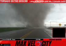
Large dangerous tornado is on the ground near McClelland and Quick, Iowa... this is NOT the same tornado that's got Pigeon, IA in it's path.
 

packyderms_wife

Neither here nor there.
Tornado Warning
NEC119-139-167-179-262300-
/O.NEW.KOAX.TO.W.0041.240426T2217Z-240426T2300Z/

BULLETIN - EAS ACTIVATION REQUESTED
Tornado Warning
National Weather Service Omaha/Valley Nebraska
517 PM CDT Fri Apr 26 2024

The National Weather Service in Omaha has issued a

* Tornado Warning for...
Northeastern Madison County in northeastern Nebraska...
Southwestern Wayne County in northeastern Nebraska...
Southeastern Pierce County in northeastern Nebraska...
Northwestern Stanton County in northeastern Nebraska...

* Until 600 PM CDT.

* At 517 PM CDT, a severe thunderstorm capable of producing a tornado
was located 3 miles southeast of Norfolk, moving north at 25 mph.

HAZARD...Tornado and half dollar size hail.

SOURCE...Radar indicated rotation.

IMPACT...Flying debris will be dangerous to those caught without
shelter. Mobile homes will be damaged or destroyed.
Damage to roofs, windows, and vehicles will occur. Tree
damage is likely.

* This dangerous storm will be near...
Norfolk around 525 PM CDT.
Hoskins around 530 PM CDT.

PRECAUTIONARY/PREPAREDNESS ACTIONS...

TAKE COVER NOW! Move to a basement or an interior room on the lowest
floor of a sturdy building. Avoid windows. If you are outdoors, in a
mobile home, or in a vehicle, move to the closest substantial shelter
and protect yourself from flying debris.

&&

LAT...LON 4193 9732 4196 9748 4230 9739 4224 9709
TIME...MOT...LOC 2217Z 201DEG 22KT 4199 9739

TORNADO...RADAR INDICATED
MAX HAIL SIZE...1.25 IN

$$

Petersen
 

packyderms_wife

Neither here nor there.
Kansas
Tornado Warning
KSC011-262300-
/O.NEW.KSGF.TO.W.0012.240426T2210Z-240426T2300Z/

BULLETIN - EAS ACTIVATION REQUESTED
Tornado Warning
National Weather Service Springfield MO
510 PM CDT Fri Apr 26 2024

The National Weather Service in Springfield has issued a

* Tornado Warning for...
Bourbon County in southeastern Kansas...

* Until 600 PM CDT.

* At 509 PM CDT, a severe thunderstorm capable of producing a tornado
was located near Moran, or 10 miles southeast of La Harpe, moving
east at 45 mph. This storm has had a history of producing
tornadoes and large hail.

HAZARD...Tornado and ping pong ball size hail.

SOURCE...Radar indicated rotation.

IMPACT...Flying debris will be dangerous to those caught without
shelter. Mobile homes will be damaged or destroyed.
Damage to roofs, windows, and vehicles will occur. Tree
damage is likely.

* Locations impacted include...
Fort Scott, Marmaton, Bronson, Uniontown, Fulton, Redfield,
Mapleton, Harding, Pawnee Station, Hiattville, Petersburg, Hammond,
Devon, Garland, Porterville, and Xenia.

PRECAUTIONARY/PREPAREDNESS ACTIONS...

TAKE COVER NOW! Move to a basement or an interior room on the lowest
floor of a sturdy building. Avoid windows. If you are outdoors, in a
mobile home, or in a vehicle, move to the closest substantial shelter
and protect yourself from flying debris.

&&

LAT...LON 3800 9508 3804 9461 3767 9462 3767 9500
3768 9500 3768 9509
TIME...MOT...LOC 2209Z 260DEG 40KT 3782 9515

TORNADO...RADAR INDICATED
MAX HAIL SIZE...1.50 IN

$$

Camden
 

packyderms_wife

Neither here nor there.
Iowa
Severe Weather Statement
National Weather Service Omaha/Valley Nebraska
522 PM CDT Fri Apr 26 2024

IAC085-155-262245-
/O.CON.KOAX.TO.W.0034.000000T0000Z-240426T2245Z/
Pottawattamie IA-Harrison IA-
522 PM CDT Fri Apr 26 2024

...A TORNADO WARNING REMAINS IN EFFECT UNTIL 545 PM CDT FOR
NORTHWESTERN POTTAWATTAMIE AND SOUTH CENTRAL HARRISON COUNTIES...

At 522 PM CDT, a confirmed tornado was located 7 miles northwest of
Neola, or 18 miles north of Council Bluffs, moving northeast at 35
mph.

HAZARD...Damaging tornado and golf ball size hail.

SOURCE...Radar confirmed tornado.

IMPACT...Flying debris will be dangerous to those caught without
shelter. Mobile homes will be damaged or destroyed. Damage
to roofs, windows, and vehicles will occur. Tree damage is
likely.

This tornadic thunderstorm will remain over mainly rural areas of
northwestern Pottawattamie and south central Harrison Counties.

PRECAUTIONARY/PREPAREDNESS ACTIONS...

To repeat, a tornado is on the ground. TAKE COVER NOW! Move to a
basement or an interior room on the lowest floor of a sturdy
building. Avoid windows. If you are outdoors, in a mobile home, or in
a vehicle, move to the closest substantial shelter and protect
yourself from flying debris.

&&

LAT...LON 4142 9578 4145 9586 4160 9579 4153 9561
4153 9562
TIME...MOT...LOC 2222Z 208DEG 31KT 4150 9575

TORNADO...OBSERVED
MAX HAIL SIZE...1.75 IN

$$

McCoy
 

packyderms_wife

Neither here nor there.
Iowa

Tornado Warning
IAC085-155-165-262315-
/O.NEW.KOAX.TO.W.0042.240426T2225Z-240426T2315Z/

BULLETIN - EAS ACTIVATION REQUESTED
Tornado Warning
National Weather Service Omaha/Valley Nebraska
525 PM CDT Fri Apr 26 2024

The National Weather Service in Omaha has issued a

* Tornado Warning for...
North central Pottawattamie County in southwestern Iowa...
Eastern Harrison County in southwestern Iowa...
Northwestern Shelby County in southwestern Iowa...

* Until 615 PM CDT.

* At 525 PM CDT, a tornado producing storm was located 7 miles
northwest of Neola, or 20 miles north of Council Bluffs, moving
northeast at 35 mph.

HAZARD...Damaging tornado and golf ball size hail.

SOURCE...Radar confirmed tornado.

IMPACT...Flying debris will be dangerous to those caught without
shelter. Mobile homes will be damaged or destroyed.
Damage to roofs, windows, and vehicles will occur. Tree
damage is likely.

* This tornadic thunderstorm will remain over mainly rural areas of
north central Pottawattamie, eastern Harrison and northwestern
Shelby Counties, including the following locations... Portsmouth.

PRECAUTIONARY/PREPAREDNESS ACTIONS...

To repeat, a tornado is on the ground. TAKE COVER NOW! Move to a
basement or an interior room on the lowest floor of a sturdy
building. Avoid windows. If you are outdoors, in a mobile home, or in
a vehicle, move to the closest substantial shelter and protect
yourself from flying debris.

&&

LAT...LON 4145 9574 4149 9584 4186 9563 4186 9562
4176 9536
TIME...MOT...LOC 2225Z 207DEG 31KT 4152 9574

TORNADO...OBSERVED
MAX HAIL SIZE...1.75 IN

$$

McCoy
 

packyderms_wife

Neither here nor there.
Kansas

Tornado Warning
KSC013-262245-
/O.NEW.KTOP.TO.W.0012.240426T2227Z-240426T2245Z/

BULLETIN - EAS ACTIVATION REQUESTED
Tornado Warning
National Weather Service Topeka KS
527 PM CDT Fri Apr 26 2024

The National Weather Service in Topeka has issued a

* Tornado Warning for...
Northeastern Brown County in northeastern Kansas...

* Until 545 PM CDT.

* At 527 PM CDT, a severe thunderstorm capable of producing a tornado
was located near Hiawatha, moving northeast at 55 mph.

HAZARD...Tornado and half dollar size hail.

SOURCE...Radar indicated rotation.

IMPACT...Flying debris will be dangerous to those caught without
shelter. Mobile homes will be damaged or destroyed.
Damage to roofs, windows, and vehicles will occur. Tree
damage is likely.

* Locations impacted include...
Hiawatha, Reserve, and Hamlin.

PRECAUTIONARY/PREPAREDNESS ACTIONS...

TAKE COVER NOW! Move to a basement or an interior room on the lowest
floor of a sturdy building. Avoid windows. If you are outdoors, in a
mobile home, or in a vehicle, move to the closest substantial shelter
and protect yourself from flying debris.

&&

LAT...LON 3989 9534 3980 9554 3986 9565 4000 9559
4000 9534
TIME...MOT...LOC 2227Z 219DEG 46KT 3989 9556

TORNADO...RADAR INDICATED
MAX HAIL SIZE...1.25 IN

$$

Jones
 

packyderms_wife

Neither here nor there.
Nebraska


Tornado Warning
NEC147-262300-
/O.NEW.KOAX.TO.W.0043.240426T2229Z-240426T2300Z/

BULLETIN - EAS ACTIVATION REQUESTED
Tornado Warning
National Weather Service Omaha/Valley Nebraska
529 PM CDT Fri Apr 26 2024

The National Weather Service in Omaha has issued a

* Tornado Warning for...
Southeastern Richardson County in southeastern Nebraska...

* Until 600 PM CDT.

* At 529 PM CDT, a severe thunderstorm capable of producing a tornado
was located near Hiawatha, moving northeast at 45 mph.

HAZARD...Tornado and hail up to two inches in diameter.

SOURCE...Radar indicated rotation.

IMPACT...Flying debris will be dangerous to those caught without
shelter. Mobile homes will be damaged or destroyed.
Damage to roofs, windows, and vehicles will occur. Tree
damage is likely.

* This dangerous storm will be near...
Rulo around 540 PM CDT.

PRECAUTIONARY/PREPAREDNESS ACTIONS...

TAKE COVER NOW! Move to a basement or an interior room on the lowest
floor of a sturdy building. Avoid windows. If you are outdoors, in a
mobile home, or in a vehicle, move to the closest substantial shelter
and protect yourself from flying debris.

&&

LAT...LON 4014 9544 4012 9540 4007 9540 4006 9542
4003 9540 4003 9536 4001 9531 4000 9531
4000 9559
TIME...MOT...LOC 2229Z 221DEG 40KT 3989 9554

TORNADO...RADAR INDICATED
MAX HAIL SIZE...2.00 IN

$$

BD
 

packyderms_wife

Neither here nor there.
Kansas

Tornado Warning
NEC147-262300-
/O.NEW.KOAX.TO.W.0043.240426T2229Z-240426T2300Z/

BULLETIN - EAS ACTIVATION REQUESTED
Tornado Warning
National Weather Service Omaha/Valley Nebraska
529 PM CDT Fri Apr 26 2024

The National Weather Service in Omaha has issued a

* Tornado Warning for...
Southeastern Richardson County in southeastern Nebraska...

* Until 600 PM CDT.

* At 529 PM CDT, a severe thunderstorm capable of producing a tornado
was located near Hiawatha, moving northeast at 45 mph.

HAZARD...Tornado and hail up to two inches in diameter.

SOURCE...Radar indicated rotation.

IMPACT...Flying debris will be dangerous to those caught without
shelter. Mobile homes will be damaged or destroyed.
Damage to roofs, windows, and vehicles will occur. Tree
damage is likely.

* This dangerous storm will be near...
Rulo around 540 PM CDT.

PRECAUTIONARY/PREPAREDNESS ACTIONS...

TAKE COVER NOW! Move to a basement or an interior room on the lowest
floor of a sturdy building. Avoid windows. If you are outdoors, in a
mobile home, or in a vehicle, move to the closest substantial shelter
and protect yourself from flying debris.

&&

LAT...LON 4014 9544 4012 9540 4007 9540 4006 9542
4003 9540 4003 9536 4001 9531 4000 9531
4000 9559
TIME...MOT...LOC 2229Z 221DEG 40KT 3989 9554

TORNADO...RADAR INDICATED
MAX HAIL SIZE...2.00 IN

$$

BD
 

packyderms_wife

Neither here nor there.

homecanner1

Veteran Member
Yup its a super cell, 10 spawned so far per Ryan and Andy.

Look at the definition of this monster's footprint

Screenshot of it outside Soldier and Ute Iowa

F6CF15CD-7C5A-46D8-9833-9ADBFE05BB5B.jpeg
 

packyderms_wife

Neither here nor there.
Severe Weather Statement
National Weather Service Omaha/Valley Nebraska
540 PM CDT Fri Apr 26 2024

NEC179-262300-
/O.CON.KOAX.TO.W.0041.000000T0000Z-240426T2300Z/
Wayne NE-
540 PM CDT Fri Apr 26 2024

...A TORNADO WARNING REMAINS IN EFFECT UNTIL 600 PM CDT FOR
SOUTHWESTERN WAYNE COUNTY...

At 539 PM CDT, a severe thunderstorm capable of producing a tornado
was located over Hoskins, or 8 miles northeast of Norfolk, moving
north at 25 mph.

HAZARD...Tornado and half dollar size hail.

SOURCE...Radar indicated rotation.

IMPACT...Flying debris will be dangerous to those caught without
shelter. Mobile homes will be damaged or destroyed. Damage
to roofs, windows, and vehicles will occur. Tree damage is
likely.

Locations impacted include...
Winside and Hoskins.

PRECAUTIONARY/PREPAREDNESS ACTIONS...

TAKE COVER NOW! Move to a basement or an interior room on the lowest
floor of a sturdy building. Avoid windows. If you are outdoors, in a
mobile home, or in a vehicle, move to the closest substantial shelter
and protect yourself from flying debris.

&&

LAT...LON 4224 9709 4209 9724 4209 9737 4229 9737
TIME...MOT...LOC 2239Z 201DEG 22KT 4213 9731

TORNADO...RADAR INDICATED
MAX HAIL SIZE...1.25 IN

$$

Petersen
 

packyderms_wife

Neither here nor there.
IOWA

Severe Weather Statement
National Weather Service Omaha/Valley Nebraska
543 PM CDT Fri Apr 26 2024

IAC155-262300-
/O.COR.KOAX.TO.W.0038.000000T0000Z-240426T2300Z/
Pottawattamie IA-
543 PM CDT Fri Apr 26 2024

...TORNADO EMERGENCY FOR MINDEN...

...A TORNADO WARNING REMAINS IN EFFECT UNTIL 600 PM CDT FOR NORTH
CENTRAL POTTAWATTAMIE COUNTY...


At 543 PM CDT, a confirmed large and destructive tornado was located
over Minden, or 17 miles southwest of Harlan, moving northeast at 35
mph.

TORNADO EMERGENCY for Minden. This is a PARTICULARLY DANGEROUS
SITUATION. TAKE COVER NOW!


HAZARD...Deadly tornado.

SOURCE...Weather spotters confirmed tornado.

IMPACT...You are in a life-threatening situation. Flying debris may
be deadly to those caught without shelter. Mobile homes
will be destroyed. Considerable damage to homes,
businesses, and vehicles is likely and complete destruction
is possible.

Locations impacted include...
Neola, Shelby, Minden, and Arrowhead Park.

PRECAUTIONARY/PREPAREDNESS ACTIONS...

To repeat, a large, extremely dangerous, and potentially deadly
tornado is on the ground. To protect your life, TAKE COVER NOW! Move
to an interior room on the lowest floor of a sturdy building. Avoid
windows. If in a mobile home, a vehicle or outdoors, move to the
closest substantial shelter and protect yourself from flying debris.

&&

LAT...LON 4135 9555 4136 9565 4151 9560 4150 9542
TIME...MOT...LOC 2236Z 208DEG 32KT 4141 9558

TORNADO...OBSERVED
TORNADO DAMAGE THREAT...CATASTROPHIC
MAX HAIL SIZE...1.75 IN

$$

BLB
 

packyderms_wife

Neither here nor there.
Iowa

Tornado Warning
IAC137-145-262330-
/O.NEW.KOAX.TO.W.0046.240426T2249Z-240426T2330Z/

BULLETIN - EAS ACTIVATION REQUESTED
Tornado Warning
National Weather Service Omaha/Valley Nebraska
549 PM CDT Fri Apr 26 2024

The National Weather Service in Omaha has issued a

* Tornado Warning for...
Southeastern Montgomery County in southwestern Iowa...
Central Page County in southwestern Iowa...

* Until 630 PM CDT.

* At 549 PM CDT, a severe thunderstorm capable of producing a tornado
was located over Blanchard, or 13 miles southwest of Clarinda,
moving northeast at 45 mph.

HAZARD...Tornado and golf ball size hail.

SOURCE...Radar indicated rotation.

IMPACT...Flying debris will be dangerous to those caught without
shelter. Mobile homes will be damaged or destroyed.
Damage to roofs, windows, and vehicles will occur. Tree
damage is likely.

* This dangerous storm will be near...
College Springs and Coin around 555 PM CDT.
Clarinda around 600 PM CDT.

Other locations in the path of this tornadic thunderstorm include
Villisca.

PRECAUTIONARY/PREPAREDNESS ACTIONS...

TAKE COVER NOW! Move to a basement or an interior room on the lowest
floor of a sturdy building. Avoid windows. If you are outdoors, in a
mobile home, or in a vehicle, move to the closest substantial shelter
and protect yourself from flying debris.

&&

LAT...LON 4057 9511 4058 9534 4110 9493 4073 9493
TIME...MOT...LOC 2249Z 212DEG 37KT 4060 9520

TORNADO...RADAR INDICATED
MAX HAIL SIZE...1.75 IN

$$

Nicolaisen
 

packyderms_wife

Neither here nor there.
Iowa

Severe Weather Statement
National Weather Service Omaha/Valley Nebraska
549 PM CDT Fri Apr 26 2024

IAC085-165-262345-
/O.CON.KOAX.TO.W.0044.000000T0000Z-240426T2345Z/
Harrison IA-Shelby IA-
549 PM CDT Fri Apr 26 2024

...TORNADO EMERGENCY FOR western Shelby, Interstate 80 near
Shelby, and Tennant...

...A TORNADO WARNING REMAINS IN EFFECT UNTIL 645 PM CDT FOR
SOUTHEASTERN HARRISON AND CENTRAL SHELBY COUNTIES...


At 548 PM CDT, a confirmed large and destructive tornado was located
near Shelby, or 12 miles southwest of Harlan, moving northeast at 40
mph.

TORNADO EMERGENCY for western Shelby, Interstate 80 near Shelby, and
Tennant. This is a PARTICULARLY DANGEROUS SITUATION. TAKE COVER NOW!

HAZARD...Deadly tornado.

SOURCE...Weather spotters confirmed tornado.

IMPACT...You are in a life-threatening situation. Flying debris may
be deadly to those caught without shelter. Mobile homes
will be destroyed. Considerable damage to homes,
businesses, and vehicles is likely and complete destruction
is possible.

The tornado will be near...
Harlan around 605 PM CDT.
Tennant around 600 PM CDT.

Other locations in the path of this tornadic thunderstorm include
Irwin and Defiance.

PRECAUTIONARY/PREPAREDNESS ACTIONS...

To repeat, a large, extremely dangerous, and potentially deadly
tornado is on the ground. To protect your life, TAKE COVER NOW! Move
to an interior room on the lowest floor of a sturdy building. Avoid
windows. If in a mobile home, a vehicle or outdoors, move to the
closest substantial shelter and protect yourself from flying debris.

&&

LAT...LON 4151 9560 4186 9543 4186 9510 4180 9509
4150 9542
TIME...MOT...LOC 2248Z 209DEG 35KT 4152 9550

TORNADO...OBSERVED
TORNADO DAMAGE THREAT...CATASTROPHIC
MAX HAIL SIZE...1.75 IN

$$

BLB
 

packyderms_wife

Neither here nor there.
Texas

Tornado Warning
TXC037-067-343-262315-
/O.NEW.KSHV.TO.W.0004.240426T2249Z-240426T2315Z/

BULLETIN - EAS ACTIVATION REQUESTED
Tornado Warning
National Weather Service Shreveport LA
549 PM CDT Fri Apr 26 2024

The National Weather Service in Shreveport has issued a

* Tornado Warning for...
Northern Cass County in northeastern Texas...
Southwestern Bowie County in northeastern Texas...
Northeastern Morris County in northeastern Texas...

* Until 615 PM CDT.

* At 549 PM CDT, a severe thunderstorm capable of producing a tornado
was located near Naples, or 20 miles southwest of New Boston,
moving northeast at 50 mph.

HAZARD...Tornado and quarter size hail.

SOURCE...Radar indicated rotation.

IMPACT...Flying debris will be dangerous to those caught without
shelter. Mobile homes will be damaged or destroyed.
Damage to roofs, windows, and vehicles will occur. Tree
damage is likely.

* This dangerous storm will be near...
Maud around 605 PM CDT.

Other locations impacted by this tornadic thunderstorm include Bryans
Mill, Marietta, Douglassville, and Spring Hill.

PRECAUTIONARY/PREPAREDNESS ACTIONS...

TAKE COVER NOW! Move to a basement or an interior room on the lowest
floor of a sturdy building. Avoid windows. If you are outdoors, in a
mobile home, or in a vehicle, move to the closest substantial shelter
and protect yourself from flying debris.

&&

LAT...LON 3328 9472 3357 9442 3357 9440 3358 9438
3357 9438 3356 9440 3354 9438 3354 9435
3320 9413 3305 9467
TIME...MOT...LOC 2249Z 233DEG 42KT 3321 9461

TORNADO...RADAR INDICATED
MAX HAIL SIZE...1.00 IN

$$

09
 

packyderms_wife

Neither here nor there.
KS/MO


Tornado Warning
KSC011-MOC217-262330-
/O.NEW.KSGF.TO.W.0013.240426T2252Z-240426T2330Z/

BULLETIN - EAS ACTIVATION REQUESTED
Tornado Warning
National Weather Service Springfield MO
552 PM CDT Fri Apr 26 2024

The National Weather Service in Springfield has issued a

* Tornado Warning for...
Northeastern Bourbon County in southeastern Kansas...
Northern Vernon County in west central Missouri...

* Until 630 PM CDT.

* At 551 PM CDT, a severe thunderstorm capable of producing a tornado
was located near Fulton, or 7 miles north of Fort Scott, moving
east at 30 mph. This storm has a history of producing tornadoes
and ping pong ball sized hail. This replaces the previously issued
tornado warning for Bourbon county.

HAZARD...Tornado and ping pong ball size hail.

SOURCE...Radar indicated rotation.

IMPACT...Flying debris will be dangerous to those caught without
shelter. Mobile homes will be damaged or destroyed.
Damage to roofs, windows, and vehicles will occur. Tree
damage is likely.

* Locations impacted include...
Walker, Schell City, Fulton, Richards, Metz, Harwood, Stotesbury,
Hammond, Horton, and Harding.

This includes Interstate 49 between mile markers 94 and 107.

PRECAUTIONARY/PREPAREDNESS ACTIONS...

TAKE COVER NOW! Move to a basement or an interior room on the lowest
floor of a sturdy building. Avoid windows. If you are outdoors, in a
mobile home, or in a vehicle, move to the closest substantial shelter
and protect yourself from flying debris.

&&

LAT...LON 3800 9484 3806 9449 3805 9424 3803 9423
3805 9421 3804 9419 3806 9413 3804 9411
3805 9410 3803 9406 3790 9407 3785 9479
TIME...MOT...LOC 2251Z 252DEG 25KT 3794 9470

TORNADO...RADAR INDICATED
MAX HAIL SIZE...1.50 IN

$$

Camden
 

packyderms_wife

Neither here nor there.
Iowa

Severe Weather Statement
National Weather Service Omaha/Valley Nebraska
558 PM CDT Fri Apr 26 2024

IAC085-165-262345-
/O.CON.KOAX.TO.W.0044.000000T0000Z-240426T2345Z/
Harrison IA-Shelby IA-
558 PM CDT Fri Apr 26 2024

...TORNADO EMERGENCY FOR TENNANT...

...A TORNADO WARNING REMAINS IN EFFECT UNTIL 645 PM CDT FOR EASTERN
HARRISON AND CENTRAL SHELBY COUNTIES...


At 557 PM CDT, a confirmed large and destructive tornado was located
5 miles north of Shelby, 2 miles south of Tennant, or 7 miles
southwest of Harlan, moving northeast at 35 mph.

TORNADO EMERGENCY for Tennant. This is a PARTICULARLY DANGEROUS
SITUATION. TAKE COVER NOW!

HAZARD...Deadly tornado.

SOURCE...Radar and spotter confirmed tornado.

IMPACT...You are in a life-threatening situation. Flying debris may
be deadly to those caught without shelter. Mobile homes
will be destroyed. Considerable damage to homes,
businesses, and vehicles is likely and complete destruction
is possible.

The tornado will be near...
Tennant at 600 PM CDT
Harlan around 605 PM CDT.

Other locations in the path of this tornadic thunderstorm include
Irwin.

PRECAUTIONARY/PREPAREDNESS ACTIONS...

To repeat, a large, extremely dangerous, and potentially deadly
tornado is on the ground. To protect your life, TAKE COVER NOW! Move
to an interior room on the lowest floor of a sturdy building. Avoid
windows. If in a mobile home, a vehicle or outdoors, move to the
closest substantial shelter and protect yourself from flying debris.

&&

LAT...LON 4169 9551 4186 9541 4186 9510 4180 9509
4152 9540 4152 9549 4160 9555
TIME...MOT...LOC 2257Z 213DEG 29KT 4158 9544

TORNADO...OBSERVED
TORNADO DAMAGE THREAT...CATASTROPHIC
MAX HAIL SIZE...1.75 IN

$$

BLB
 

packyderms_wife

Neither here nor there.
Severe Weather Statement
National Weather Service Omaha/Valley Nebraska
604 PM CDT Fri Apr 26 2024

IAC165-262345-
/O.CON.KOAX.TO.W.0044.000000T0000Z-240426T2345Z/
Shelby IA-
604 PM CDT Fri Apr 26 2024

...TORNADO EMERGENCY FOR Harlan...

...A TORNADO WARNING REMAINS IN EFFECT UNTIL 645 PM CDT FOR CENTRAL
SHELBY COUNTY...

At 604 PM CDT, a confirmed large and destructive tornado was located
3 miles west of Harlan, moving northeast at 40 mph.

TORNADO EMERGENCY for Harlan. This is a PARTICULARLY DANGEROUS
SITUATION. TAKE COVER NOW!

HAZARD...Deadly tornado.

SOURCE...Weather spotters confirmed a very large tornado moving
toward Harlan.

IMPACT...You are in a life-threatening situation. Flying debris may
be deadly to those caught without shelter. Mobile homes
will be destroyed. Considerable damage to homes,
businesses, and vehicles is likely and complete destruction
is possible.

The tornado will be near...
Harlan around 610 PM CDT.

Other locations in the path of this tornadic thunderstorm include
Irwin.

PRECAUTIONARY/PREPAREDNESS ACTIONS...

To repeat, a large, extremely dangerous, and potentially deadly
tornado is on the ground. To protect your life, TAKE COVER NOW! Move
to an interior room on the lowest floor of a sturdy building. Avoid
windows. If in a mobile home, a vehicle or outdoors, move to the
closest substantial shelter and protect yourself from flying debris.

&&

LAT...LON 4173 9546 4186 9538 4186 9510 4180 9509
4156 9536 4156 9544 4164 9550
TIME...MOT...LOC 2304Z 216DEG 33KT 4163 9539

TORNADO...OBSERVED
TORNADO DAMAGE THREAT...CATASTROPHIC
MAX HAIL SIZE...1.75 IN

$$

BLB
 

packyderms_wife

Neither here nor there.
Oklahoma
Severe Weather Statement
National Weather Service Tulsa OK
601 PM CDT Fri Apr 26 2024

OKC035-262315-
/O.CON.KTSA.TO.W.0016.000000T0000Z-240426T2315Z/
Craig OK-
601 PM CDT Fri Apr 26 2024

...A TORNADO WARNING REMAINS IN EFFECT UNTIL 615 PM CDT FOR SOUTHERN
CRAIG COUNTY...

At 601 PM CDT, a severe thunderstorm capable of producing a tornado
was located over White Oak, moving northeast at 40 mph.

HAZARD...Tornado and ping pong ball size hail.

SOURCE...Radar indicated rotation.

IMPACT...Flying debris will be dangerous to those caught without
shelter. Mobile homes will be damaged or destroyed. Damage
to roofs, windows, and vehicles will occur. Tree damage is
likely.

Locations in or near the path include...
Vinita... White Oak...

This includes Interstate 44 between mile markers 278 and 288.

PRECAUTIONARY/PREPAREDNESS ACTIONS...

TAKE COVER NOW! Move to a basement or an interior room on the lowest
floor of a sturdy building. Avoid windows. If you are outdoors, in a
mobile home, or in a vehicle, move to the closest substantial shelter
and protect yourself from flying debris.

&&

LAT...LON 3660 9500 3657 9501 3656 9531 3657 9533
3660 9533 3660 9540 3682 9522
TIME...MOT...LOC 2301Z 233DEG 33KT 3662 9529

TORNADO...RADAR INDICATED
MAX HAIL SIZE...1.50 IN

$$
 

packyderms_wife

Neither here nor there.
Texas


Severe Weather Statement
National Weather Service Shreveport LA
600 PM CDT Fri Apr 26 2024

TXC037-067-262315-
/O.CON.KSHV.TO.W.0004.000000T0000Z-240426T2315Z/
Cass TX-Bowie TX-
600 PM CDT Fri Apr 26 2024

...A TORNADO WARNING REMAINS IN EFFECT UNTIL 615 PM CDT FOR NORTHERN
CASS AND SOUTHWESTERN BOWIE COUNTIES...

At 559 PM CDT, a severe thunderstorm capable of producing a tornado
was located 9 miles west of Maud, or 13 miles south of New Boston,
moving northeast at 50 mph.

HAZARD...Tornado and quarter size hail.

SOURCE...Radar indicated rotation.

IMPACT...Flying debris will be dangerous to those caught without
shelter. Mobile homes will be damaged or destroyed. Damage
to roofs, windows, and vehicles will occur. Tree damage is
likely.

This dangerous storm will be near...
Maud around 605 PM CDT.
Hooks and Redwater around 615 PM CDT.

Other locations impacted by this tornadic thunderstorm include Bryans
Mill, Douglassville, and Spring Hill.

PRECAUTIONARY/PREPAREDNESS ACTIONS...

TAKE COVER NOW! Move to a basement or an interior room on the lowest
floor of a sturdy building. Avoid windows. If you are outdoors, in a
mobile home, or in a vehicle, move to the closest substantial shelter
and protect yourself from flying debris.

&&

LAT...LON 3357 9442 3357 9440 3358 9438 3357 9438
3356 9440 3354 9438 3354 9435 3320 9413
3319 9417 3318 9458 3333 9467
TIME...MOT...LOC 2259Z 233DEG 42KT 3328 9450

TORNADO...RADAR INDICATED
MAX HAIL SIZE...1.00 IN

$$

09
 

packyderms_wife

Neither here nor there.
Missouri

Tornado Warning
MOC005-087-147-262330-
/O.NEW.KEAX.TO.W.0003.240426T2304Z-240426T2330Z/

BULLETIN - EAS ACTIVATION REQUESTED
Tornado Warning
National Weather Service Kansas City/Pleasant Hill MO
604 PM CDT Fri Apr 26 2024

The National Weather Service in Pleasant Hill has issued a

* Tornado Warning for...
Southeastern Atchison County in northwestern Missouri...
Northeastern Holt County in northwestern Missouri...
Western Nodaway County in northwestern Missouri...

* Until 630 PM CDT.

* At 604 PM CDT, a severe thunderstorm capable of producing a tornado
was located near Mound City, moving northeast at 55 mph.

HAZARD...Tornado and ping pong ball size hail.

SOURCE...Radar indicated rotation.

IMPACT...Flying debris will be dangerous to those caught without
shelter. Mobile homes will be damaged or destroyed.
Damage to roofs, windows, and vehicles will occur. Tree
damage is likely.

* Locations impacted include...
Maryville, Burlington Junction, Maitland, Skidmore, and Quitman.

PRECAUTIONARY/PREPAREDNESS ACTIONS...

TAKE COVER NOW! Move to a basement or an interior room on the lowest
floor of a sturdy building. Avoid windows. If you are outdoors, in a
mobile home, or in a vehicle, move to the closest substantial shelter
and protect yourself from flying debris.

&&

LAT...LON 4012 9519 4022 9531 4052 9498 4034 9482
TIME...MOT...LOC 2304Z 226DEG 47KT 4019 9520

TORNADO...RADAR INDICATED
MAX HAIL SIZE...1.50 IN

$$

Blair
 
Status
Not open for further replies.
Top